Introduction
Uttar Pradesh is the most populous state in India and one of the largest by area, which is why its administrative map carries an unusual weight in Prelims questions, state-PCS quizzes, and everyday general knowledge. Aspirants routinely stumble on one question: how many districts are in UP today, and how are they grouped into divisions? The headline number is 75 districts arranged into 18 administrative divisions, but the deeper story involves repeated reorganisations since 1947, the carving out of Uttarakhand in 2000, and persistent demands for further bifurcation of giant districts such as Lucknow, Prayagraj, and Gorakhpur.
This reference guide consolidates the full list of 75 districts, maps each one to its parent division, and explains why Uttar Pradesh’s administrative geography matters for UPSC aspirants. You will find division-wise tables, population and area benchmarks from Census 2011 (the latest published Census), historical context on district creation, and a set of Prelims-ready pointers that capture the frequently tested facts.
Quick Facts at a Glance
| Parameter | Value |
|---|---|
| Total districts | 75 |
| Total divisions | 18 |
| Largest district by area | Lakhimpur Kheri (7,680 sq km) |
| Smallest district by area | Hapur (~660 sq km) |
| Most populous district | Prayagraj (5.95 million, Census 2011) |
| Least populous district | Mahoba (~876,000) |
| Newest district | Shamli, Hapur, Sambhal (created 2011) |
| Capital | Lucknow |
| Total area | 2,40,928 sq km |
| Population (Census 2011) | 19.98 crore |
Background and Historical Context
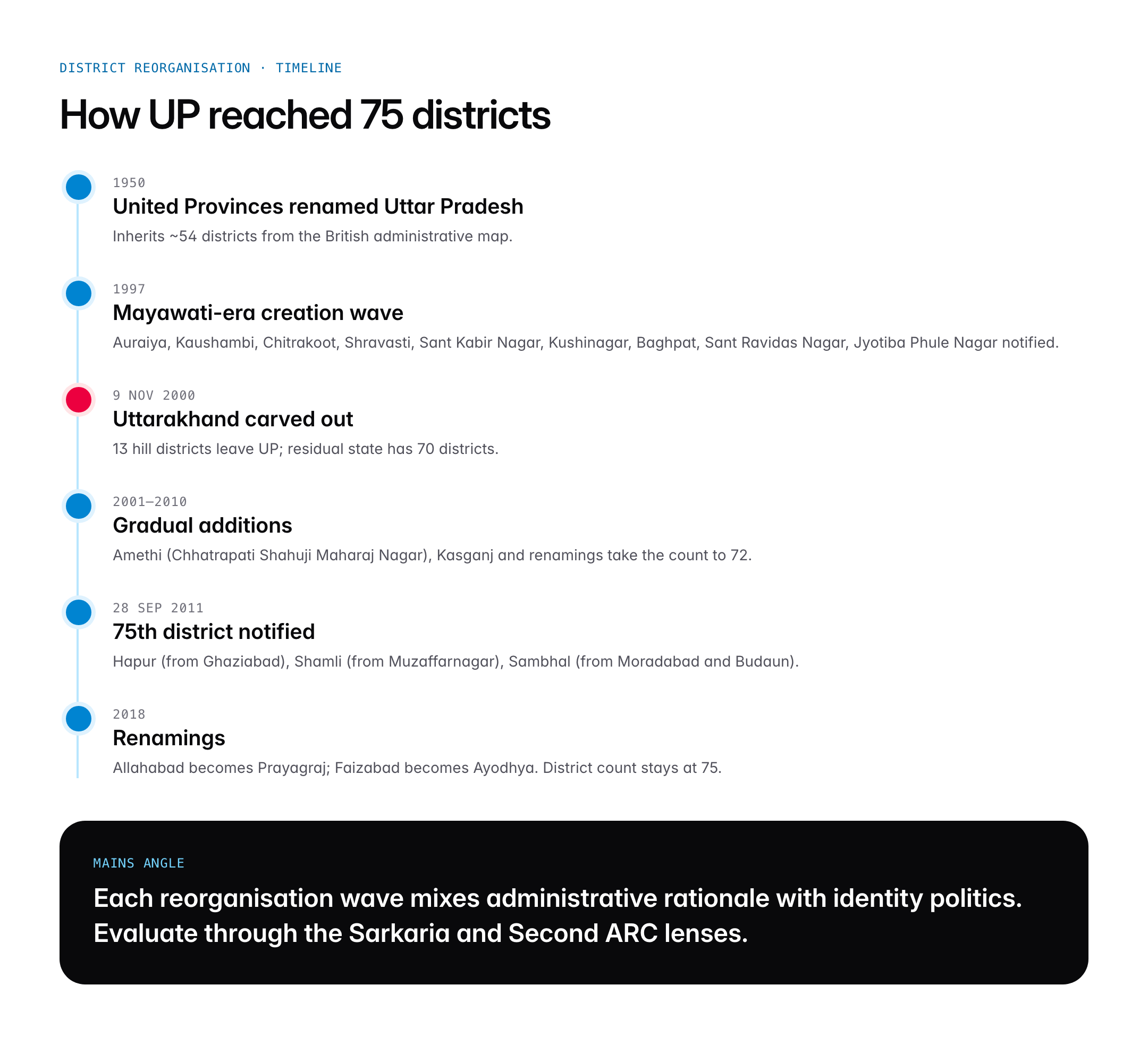
When India became independent in 1947, the United Provinces, renamed Uttar Pradesh in 1950, inherited an administrative framework originally built by the British. The state then had far fewer districts, and successive state governments have repeatedly split larger units to bring administration closer to citizens. The process accelerated from the 1990s onwards.
A pivotal moment arrived on 9 November 2000, when the hill districts were carved out to form the new state of Uttarakhand. Thirteen districts moved out of UP, leaving 70 districts behind. Within a decade, the state had added five more. Auraiya, Kaushambi, Chitrakoot, Shravasti, Sant Kabir Nagar, Kushinagar, Baghpat, Sant Ravidas Nagar, Jyotiba Phule Nagar (later Amroha), Balrampur, Mahamaya Nagar (later Hathras), Gautam Buddh Nagar, Mahoba, Bijnor and others were created or re-notified between 1997 and 2005 during Mayawati’s and Kalyan Singh’s tenures.
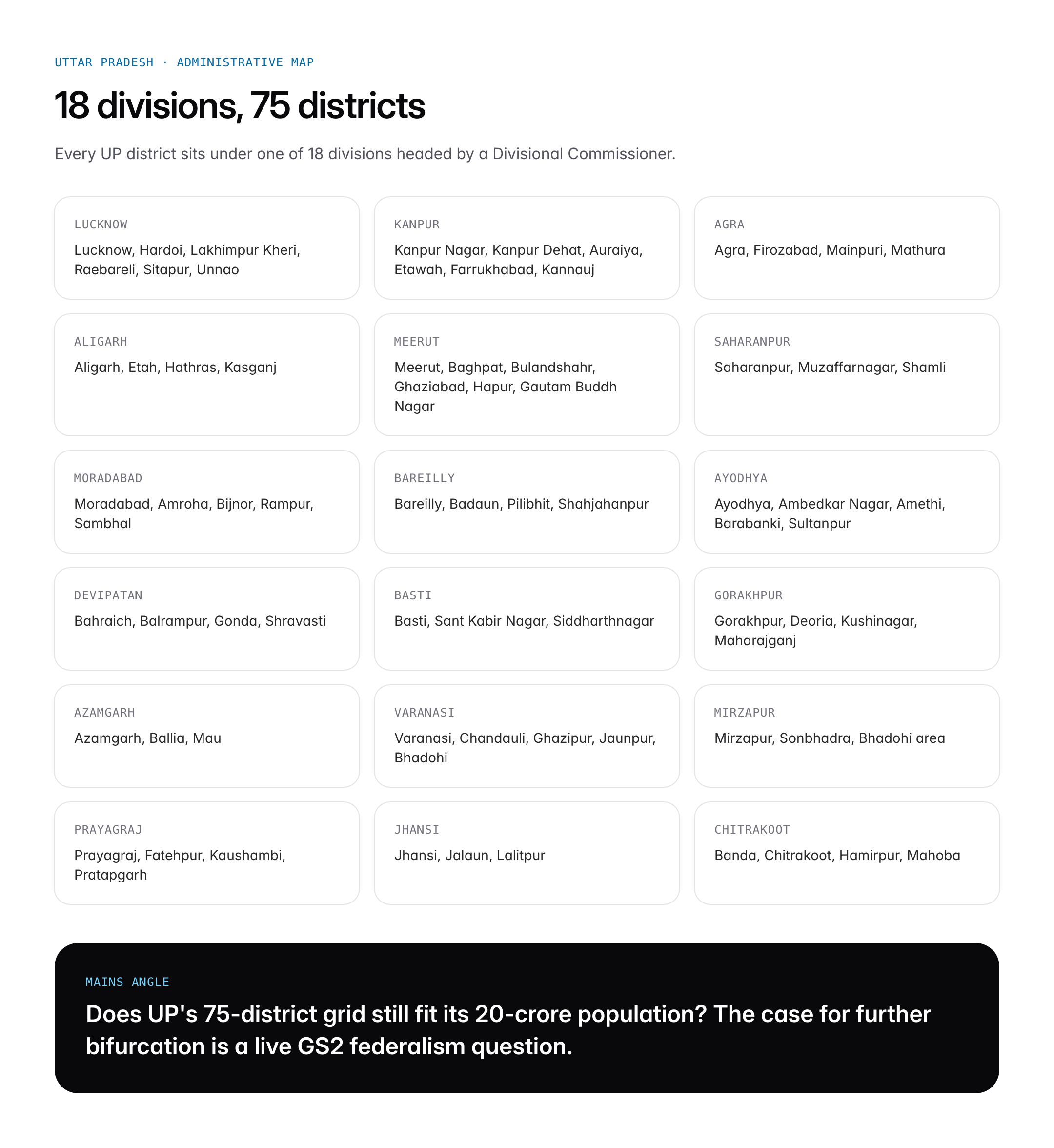
The most recent burst of reorganisation came on 28 September 2011, when three new districts were announced: Hapur (carved from Ghaziabad), Shamli (from Muzaffarnagar) and Sambhal (from Moradabad and Budaun). That round brought the state’s tally to the current 75 districts. Since then, no new district has been notified, although proposals to split Lucknow, Prayagraj, Gorakhpur and Sitapur periodically surface in the Vidhan Sabha. The 18 administrative divisions, each headed by a Divisional Commissioner, have remained stable through this period, with Aligarh and Basti among the more recent additions to the list of divisions.
Key Features of the Administrative Structure
Division-wise District List
The 75 districts of Uttar Pradesh are organised into 18 divisions, each led by a Commissioner of the rank of Principal Secretary or Additional Chief Secretary. Below is the complete division-wise list, the single table every aspirant should internalise.
| Division | Districts |
|---|---|
| Lucknow | Lucknow, Hardoi, Lakhimpur Kheri, Raebareli, Sitapur, Unnao |
| Kanpur | Kanpur Nagar, Kanpur Dehat, Auraiya, Etawah, Farrukhabad, Kannauj |
| Agra | Agra, Firozabad, Mainpuri, Mathura |
| Aligarh | Aligarh, Etah, Hathras, Kasganj |
| Meerut | Meerut, Baghpat, Bulandshahr, Ghaziabad, Hapur, Gautam Buddh Nagar |
| Saharanpur | Saharanpur, Muzaffarnagar, Shamli |
| Moradabad | Moradabad, Amroha, Bijnor, Rampur, Sambhal |
| Bareilly | Bareilly, Badaun, Pilibhit, Shahjahanpur |
| Ayodhya | Ayodhya, Ambedkar Nagar, Amethi, Barabanki, Sultanpur |
| Devipatan | Bahraich, Balrampur, Gonda, Shravasti |
| Basti | Basti, Sant Kabir Nagar, Siddharthnagar |
| Gorakhpur | Gorakhpur, Deoria, Kushinagar, Maharajganj |
| Azamgarh | Azamgarh, Ballia, Mau |
| Varanasi | Varanasi, Chandauli, Ghazipur, Jaunpur, Sant Ravidas Nagar (Bhadohi) |
| Mirzapur | Mirzapur, Sonbhadra, Prayagraj (historically Vindhyachal) |
| Prayagraj | Prayagraj, Fatehpur, Kaushambi, Pratapgarh |
| Jhansi | Jhansi, Jalaun, Lalitpur |
| Chitrakoot | Banda, Chitrakoot, Hamirpur, Mahoba |
Largest and Smallest Districts
Lakhimpur Kheri is the largest district by area at 7,680 sq km, pressed against the Nepal border and home to the Dudhwa Tiger Reserve. At the other extreme, Hapur, created only in 2011, is among the smallest at roughly 660 sq km. By population, Prayagraj (formerly Allahabad) is the most populous with nearly 6 million people per Census 2011, while Mahoba in Bundelkhand ranks among the least populated.
Urban and Industrial Giants
Gautam Buddh Nagar, home to Noida and Greater Noida, is the state’s economic showcase. Kanpur Nagar remains the old industrial capital. Ghaziabad, part of the National Capital Region, ranks among the fastest-growing urban districts in India.
Significance for UPSC and General Knowledge
- Prelims often tests division–district mapping; knowing Ayodhya and Prayagraj moved from being cities to divisions is frequent gap.
- Census 2011 data on UP districts underpins questions on demography, sex ratio, and literacy.
- Uttarakhand bifurcation in 2000 is a standard Modern India / Polity fact.
- District-level Planning (DDP) and Aspirational Districts Programme cover eight UP districts, relevant for GS2 governance.
- Boundary districts such as Lakhimpur Kheri, Bahraich, Maharajganj and Siddharthnagar touch Nepal and matter for internal security.
- Economic Survey data and NITI Aayog rankings use UP districts as analytical units.
Detailed Analysis: Reorganisation and Regional Identity
Uttar Pradesh’s 75-district architecture is less a neutral administrative grid and more a political palimpsest. Each wave of district creation corresponded to a shift in the state’s social coalition. The 1997 creation of Sant Ravidas Nagar, named after the Bhakti-era saint, and the 2008 renaming and creation of Mahamaya Nagar and Jyotiba Phule Nagar happened under Bahujan Samaj Party governments and embodied an assertion of Dalit identity on the map. The Samajwadi Party, during its tenures, reversed several of these renamings, so Jyotiba Phule Nagar became Amroha and Panchsheel Nagar became Hapur in the 2011–12 window. Prayagraj was formally renamed from Allahabad in 2018 under the current Bharatiya Janata Party government, and Faizabad became Ayodhya the same year.
Geographically, the state divides into four broad regions that map onto divisions. The western UP belt, comprising Meerut, Saharanpur, Moradabad and Agra divisions, is part of the sugarcane-wheat heartland, wealthier and more urbanised, closely linked to Delhi’s NCR. Central UP, anchored by Lucknow and Kanpur divisions, is the administrative and industrial core. Eastern UP, or Purvanchal, covering Ayodhya, Basti, Gorakhpur, Azamgarh, Varanasi and Devipatan divisions, is demographically dense but economically lagging and supplies the bulk of the state’s out-migrants. Bundelkhand, encompassing Jhansi and Chitrakoot divisions, is a drought-prone plateau with persistent agrarian distress. This regional disparity explains why there are recurring demands to trifurcate or quadrify UP into smaller states, a proposal formally mooted by the Mayawati government in 2011.
Comparative Perspective
Uttar Pradesh’s 75 districts make it the state with the third-largest number of districts in India, behind Madhya Pradesh and Maharashtra.
| State | Districts | Divisions | Population (2011) |
|---|---|---|---|
| Uttar Pradesh | 75 | 18 | 19.98 crore |
| Madhya Pradesh | 55 | 10 | 7.26 crore |
| Maharashtra | 36 | 6 | 11.23 crore |
| Bihar | 38 | 9 | 10.40 crore |
| Rajasthan | 50 | 10 | 6.85 crore |
| Tamil Nadu | 38 | 3 (regional) | 7.21 crore |
The ratio of population to districts reveals that UP has roughly 2.66 million people per district, far above the Indian average of around 1.3 million. This is one reason why civil society groups and retired bureaucrats have argued for creating more districts, on the logic that administration is stretched too thin over too large populations.
Challenges and Debates
The first debate concerns administrative load. Districts like Lucknow, Prayagraj, Gorakhpur and Sitapur each host over three million residents, making it difficult for a single District Magistrate to oversee land records, law and order, and scheme implementation. The second debate concerns political motives. Critics argue that new districts often get announced close to elections and reflect identity politics more than administrative efficiency. The third is fiscal. Every new district requires a collectorate, police lines, a district hospital, and new government offices, stretching the state budget. Finally, there is the perennial question of whether UP itself is too large to govern as a single unit, with the 2011 quadrification proposal (Paschim Pradesh, Awadh Pradesh, Purvanchal, Bundelkhand) lapsing in the Centre without follow-through.
Prelims Pointers
- Uttar Pradesh has 75 districts and 18 divisions.
- Lakhimpur Kheri is the largest district by area at 7,680 sq km.
- Prayagraj is the most populous district (Census 2011, 5.95 million).
- Hapur, Shamli and Sambhal, created 28 September 2011, are the newest districts.
- Uttarakhand was carved out on 9 November 2000, removing 13 districts.
- Allahabad was renamed Prayagraj in 2018; Faizabad was renamed Ayodhya in 2018.
- Gautam Buddh Nagar hosts Noida, part of NCR, created in 1997.
- Dudhwa Tiger Reserve is in Lakhimpur Kheri.
- Bundelkhand region covers Jhansi and Chitrakoot divisions, including Jalaun, Lalitpur, Banda, Chitrakoot, Hamirpur, Mahoba.
- Purvanchal covers eastern UP divisions including Gorakhpur, Azamgarh, Varanasi, Basti, Devipatan.
- Eight UP districts, including Chitrakoot, Chandauli, Fatehpur and Siddharthnagar, are under the Aspirational Districts Programme of NITI Aayog.
- Sant Ravidas Nagar is also known as Bhadohi, famous for its carpet industry.
Mains Practice Questions
Q1. Critically examine the case for reorganising Uttar Pradesh into smaller states. Would such reorganisation improve administrative efficiency? (250 words)
- Outline the 2011 quadrification proposal (Paschim, Awadh, Purvanchal, Bundelkhand) and recall Article 3 of the Constitution which allows Parliament to alter state boundaries.
- Weigh arguments for: closer administration, targeted development for Bundelkhand and Purvanchal, historical precedent (Uttarakhand 2000, Telangana 2014).
- Weigh arguments against: loss of political weight at the Centre, fiscal cost, risk of recurring sub-regional demands; conclude with a balanced Sarkaria-style view.
Q2. “The creation of new districts in Uttar Pradesh since 1997 reflects both administrative necessity and identity politics.” Discuss. (250 words)
- Chart the creation waves 1997–2011 and identify which governments notified them.
- Discuss administrative rationale (span of control, scheme delivery, police bandwidth).
- Discuss identity dimension: renaming after Bhakti saints and social reformers, reversal under different regimes; conclude with a framework for neutral, criteria-based district creation.
Conclusion
Uttar Pradesh’s 75 districts and 18 divisions form one of the most closely watched administrative grids in India, because every governance question, from Aspirational Districts to election turnouts, ultimately plays out at the district level. The numbers have been stable since 2011, but the debates, on further bifurcation of megadistricts and on the viability of UP as a single state, will almost certainly return to the political agenda in this decade.
For an aspirant, the practical takeaway is to memorise the division-to-district mapping, remember the three 2011 additions, keep the Uttarakhand bifurcation date handy, and track which UP districts fall under flagship schemes like Aspirational Districts. These data points, in combination with an appreciation of the state’s regional disparities, cover the bulk of questions Uttar Pradesh’s administrative geography generates in both Prelims and Mains.
Frequently Asked Questions
How many districts are in Uttar Pradesh in 2026?
Uttar Pradesh has 75 districts as of 2026, grouped into 18 administrative divisions. No new district has been notified since September 2011, when Hapur, Shamli and Sambhal were created. The state capital is Lucknow, and the state spans 2,40,928 sq km with a Census 2011 population of 19.98 crore.
What are the 18 divisions of Uttar Pradesh?
The 18 divisions are Lucknow, Kanpur, Agra, Aligarh, Meerut, Saharanpur, Moradabad, Bareilly, Ayodhya, Devipatan, Basti, Gorakhpur, Azamgarh, Varanasi, Mirzapur, Prayagraj, Jhansi and Chitrakoot. Each division is headed by a Commissioner and groups three to six districts for revenue and administrative supervision under the state government.
Why is Uttar Pradesh’s district structure important for UPSC?
UP’s 75 districts frequently feature in Prelims through division-mapping, Census 2011 data, Aspirational Districts Programme coverage, and boundary-district questions. For Mains GS1 and GS2, the structure is a reference point for federalism, urbanisation, demographic dividend and regional disparity discussions. Its bifurcation history (Uttarakhand 2000) is standard Modern India fact.
How is the administrative structure of UP related to the Constitution?
Article 3 empowers Parliament to alter state boundaries, as was done when Uttarakhand was carved out of UP in 2000. The state itself can create or abolish districts through executive notification under the UP Land Revenue Act, without constitutional amendment. District-level planning draws strength from the 73rd and 74th Amendments on local self-government.
Which is the largest district in Uttar Pradesh?
Lakhimpur Kheri is the largest district in Uttar Pradesh by area, spanning 7,680 sq km on the Nepal border. It hosts the Dudhwa Tiger Reserve and Kishanpur Wildlife Sanctuary. By population, Prayagraj (formerly Allahabad) is the most populous district with 5.95 million residents per Census 2011, followed closely by Moradabad and Ghaziabad.
Which are the newest districts of Uttar Pradesh?
Hapur, Shamli and Sambhal, all notified on 28 September 2011, are the newest districts of Uttar Pradesh. Hapur was carved from Ghaziabad, Shamli from Muzaffarnagar, and Sambhal from Moradabad and Budaun. Since 2011, no further districts have been officially created, though several proposals exist for splitting Lucknow, Prayagraj and Sitapur.
How many districts did UP lose when Uttarakhand was formed?
Uttar Pradesh lost 13 hill and foothill districts when Uttarakhand was formed on 9 November 2000 under the Uttar Pradesh Reorganisation Act, 2000. These included Dehradun, Haridwar, Nainital, Almora, Pithoragarh, Chamoli, Rudraprayag, Tehri Garhwal, Uttarkashi, Pauri Garhwal, Bageshwar, Champawat and Udham Singh Nagar.
Which UP districts are under the Aspirational Districts Programme?
Eight UP districts are part of NITI Aayog’s Aspirational Districts Programme launched in 2018: Bahraich, Balrampur, Chandauli, Chitrakoot, Fatehpur, Shravasti, Siddharthnagar and Sonbhadra. The scheme targets health, nutrition, education, agriculture, financial inclusion and basic infrastructure through competitive, data-driven ranking updated quarterly.