India’s International Borders: Neighbouring Countries, States & Map Facts
India has a 15,106.7 km land boundary with seven countries. Learn the neighbouring countries, border states, major boundary lines, and revised coastline.
India’s international borders include a 15,106.7 km land boundary shared with seven countries: Bangladesh, China, Pakistan, Nepal, Myanmar, Bhutan and Afghanistan. Seventeen Indian states and Union Territories touch these land frontiers.
Bangladesh shares the longest boundary with India, followed by China and Pakistan. For map questions, learn the neighbouring country, the Indian states or UTs along it, and the difference between the international boundary, Line of Control, Line of Actual Control, Radcliffe Line and McMahon Line.
The Ministry of Home Affairs border-management page confirms the land-boundary total. India’s coastline was recalculated to 11,098.81 km in 2025, replacing the older 7,516.6 km figure still found in many notes.
The Seven Land Neighbours and the Lengths
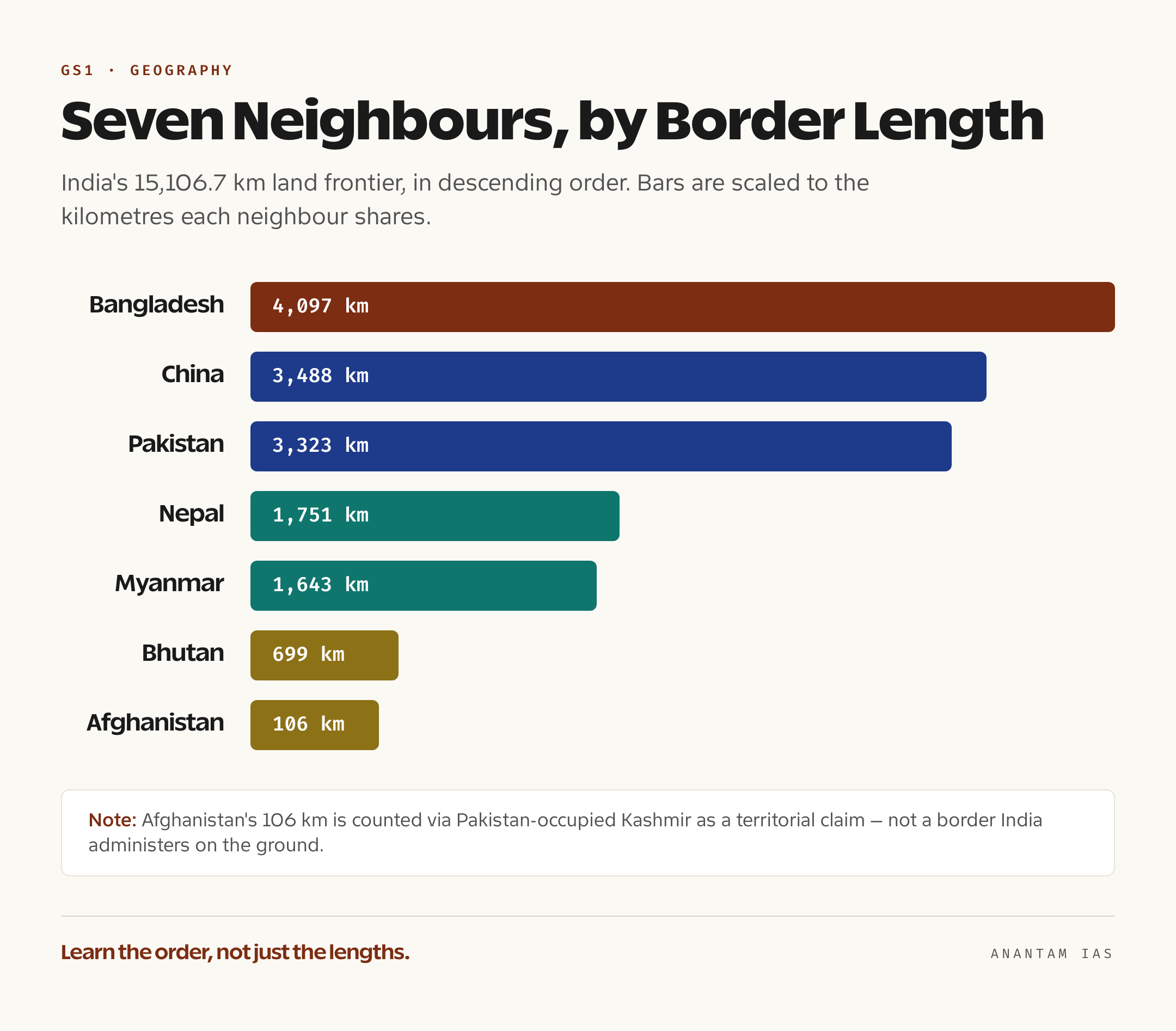
India shares its land frontier with seven sovereign neighbours, and the Ministry of Home Affairs publishes the boundary length with each. Learn these in descending order, because the ranking itself is the test point:

India and World Political Maps, laminated 70 × 100 cm (pair)
- Two maps in one set: India political and world political, 70 × 100 cm each
- Laminated on both sides, wipe-clean, with adhesive strips already applied
- Certified maps with states, countries, capitals and major physical features labelled
- Bangladesh — about 4,097 km (4,096.7 km), India’s longest land border with any single country.
- China — about 3,488 km, much of it not a settled boundary but a disputed Line of Actual Control.
- Pakistan — about 3,323 km, a mix of the international boundary and the Line of Control.
- Nepal — about 1,751 km, an open border crossed freely under the 1950 Treaty of Peace and Friendship.
- Myanmar — about 1,643 km, along the Northeast and historically a free-movement zone.
- Bhutan — about 699 km, India’s shortest fully friendly land border.
- Afghanistan — about 106 km, which India counts via Pakistan-occupied Kashmir as part of its territorial claim, and which is therefore not a border India administers on the ground.
Add those and you get the official total of 15,106.7 kilometres. The Ministry of Home Affairs notes the same boundary runs through 92 districts in 17 states, which is why border guarding involves a different paramilitary force for almost every neighbour — the Border Security Force on Pakistan and Bangladesh, the Indo-Tibetan Border Police facing China, the Sashastra Seema Bal on Nepal and Bhutan, and the Assam Rifles along Myanmar. You can see how all of this is administered in our explainer on border management.
One refinement worth carrying: the longest international border any single Indian state shares with one foreign country is the Rajasthan-Pakistan stretch across the Thar Desert, roughly 1,070 kilometres. It’s a favourite multiple-statement trap, usually paired with the claim that Rajasthan has the longest border overall — which it doesn’t, because that title belongs to the country pairing with Bangladesh, not any one state.
States That Sit on the Border
Seventeen states touch an international land boundary, and the cleanest way to fix them is by neighbour rather than as one long alphabetical blur. So group them the way the border itself runs, west to east:
- Pakistan: Gujarat, Rajasthan, Punjab, Jammu & Kashmir (UT) and Ladakh (UT).
- China: Ladakh, Himachal Pradesh, Uttarakhand, Sikkim and Arunachal Pradesh.
- Nepal: Uttarakhand, Uttar Pradesh, Bihar, West Bengal and Sikkim.
- Bhutan: Sikkim, West Bengal, Assam and Arunachal Pradesh.
- Bangladesh: West Bengal, Assam, Meghalaya, Tripura and Mizoram.
- Myanmar: Arunachal Pradesh, Nagaland, Manipur and Mizoram.
A few adjacency facts fall straight out of that grouping and recur in exams. Sikkim is the only state that touches three different countries — China, Nepal and Bhutan — at once. West Bengal is unusual in the other direction, brushing three neighbours — Nepal, Bhutan and Bangladesh. Arunachal Pradesh sits against both China and Myanmar. And the Northeast as a whole is almost an island: it connects to the rest of India only through the narrow Siliguri Corridor, the “Chicken’s Neck” in West Bengal, which is why that sliver of land carries such strategic weight.
It helps to picture this as a table rather than a map, because the disputed alignments on an actual map can mislead you. Think of two columns — neighbour on the left, the states that touch it on the right — and the relationships stay clean.
Boundary, Frontier and the Named Lines
Because the syllabus blurs them, start with a distinction examiners love: a boundary is not the same thing as a frontier. A boundary is a precise line — surveyed, demarcated and legally recognised — that marks where one state’s sovereignty ends and another’s begins. A frontier is a zone, a band of territory at the edge of settled control that is often sparsely populated and not firmly held by either side. The shift from frontiers to boundaries is the story of modern statehood: the Himalayas were once a frontier between India and Tibet, a wide buffer nobody precisely owned, and only in the colonial and modern eras did states try to convert that zone into a hard line. Where they failed to agree on the line, the dispute survives.
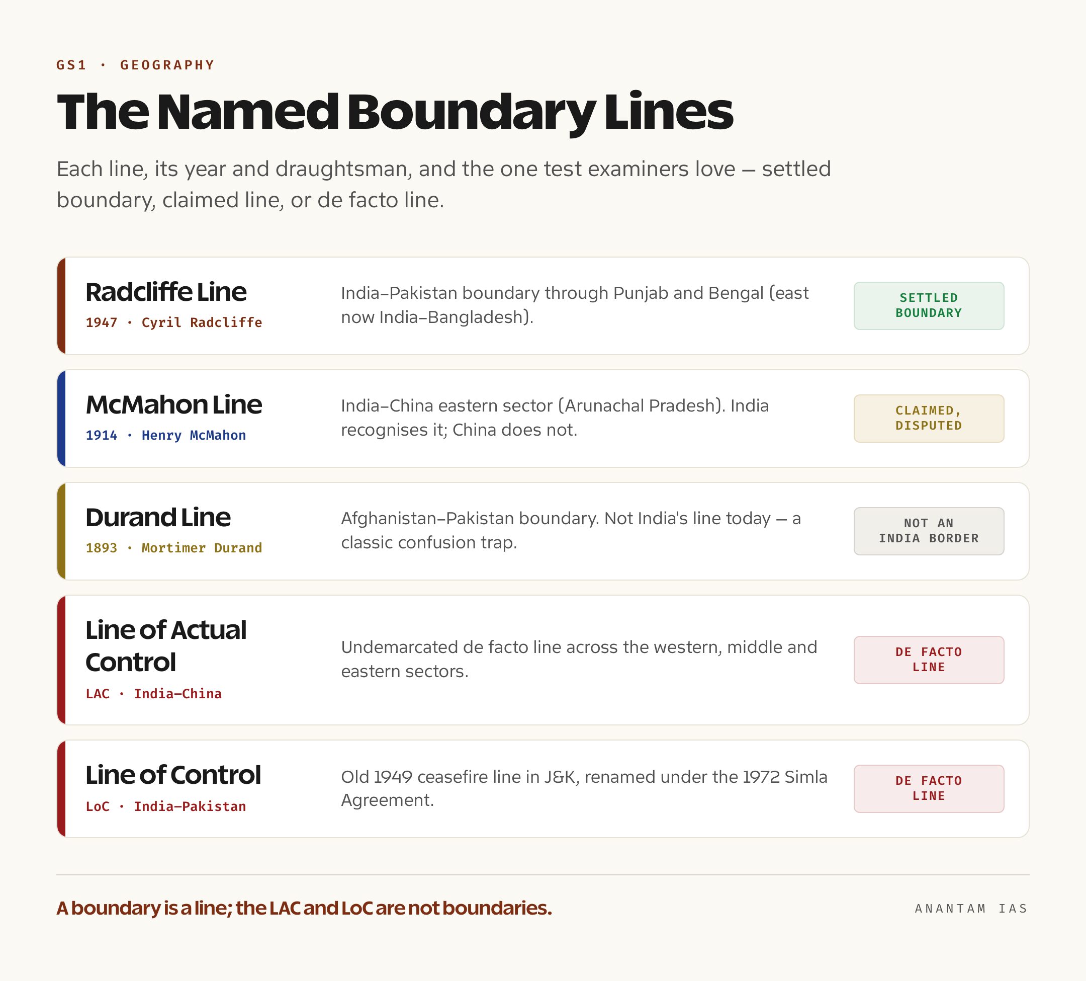
That failure is exactly why India’s borders carry named lines, and you should be able to attach each to its year, its draughtsman and the parties it divides:
- Radcliffe Line (1947) — the India-Pakistan boundary through Punjab and Bengal, drawn by the British lawyer Cyril Radcliffe and published just after Partition. It remains the legally settled international boundary on the western and eastern fronts (the latter now India-Bangladesh).
- McMahon Line (1914) — proposed by Henry McMahon at the Simla Convention as the India-China boundary in the eastern sector, along the crest of the Himalayas in present-day Arunachal Pradesh. India treats it as the boundary; China does not accept it.
- Durand Line (1893) — the Afghanistan-Pakistan boundary drawn by Mortimer Durand, a colonial-era line that today is not India’s at all, but is tested because it once marked the limit of British India.
- Line of Actual Control (LAC) — the de facto, undemarcated India-China boundary across the western, middle and eastern sectors. It is not a legal boundary; it’s where the two armies actually stand, which is why it moves and why it sparks standoffs.
- Line of Control (LoC) — the de facto India-Pakistan line in Jammu and Kashmir, the old 1949 ceasefire line renamed under the 1972 Simla Agreement. Again a military line, not a recognised international boundary.
The cleanest way to hold these is the boundary-versus-line test: Radcliffe is a settled boundary, McMahon is a boundary India recognises but its neighbour disputes, and the LAC and LoC are not boundaries at all but the living edges of unsettled disputes. That single sentence answers a surprising number of questions.
The Coastline and the Coastal States
Turn from land to sea and a second list takes over. India’s coastline was quoted for decades at 7,516.6 kilometres — about 6,100 km of mainland plus the coasts of the Andaman & Nicobar and Lakshadweep islands. But in a genuinely current development, the Ministry of Ports, Shipping and Waterways promulgated a revised figure in April 2025: 11,098.81 kilometres, an increase of nearly half. Nothing physically grew; the National Hydrographic Office and Survey of India simply re-measured at a far finer scale (1:250,000 against the older small-scale calculation) using high-resolution charts, capturing every creek and inlet the old method smoothed over. If a question quotes 7,516.6 km it’s using the classic figure; if it quotes around 11,099 km it’s using the 2025 revision. Know both.
The coast touches nine states and four union territories — fix it as 9 + 4. The nine states, running clockwise from the east, are West Bengal, Odisha, Andhra Pradesh, Tamil Nadu, Kerala, Karnataka, Goa, Maharashtra and Gujarat. The four union territories are Puducherry, the Andaman & Nicobar Islands, Lakshadweep, and the merged UT of Dadra & Nagar Haveli and Daman & Diu. Gujarat has the longest mainland coastline of any state — itself revised in 2025 to about 2,340 km — while Goa has the shortest. Put the land and sea lists together and the Home Ministry’s point becomes clear: every state except a landlocked core (Madhya Pradesh, Chhattisgarh, Jharkhand, Haryana, Telangana and the like) either guards a border or a coast.
The States That Touch the Most Neighbours
A final cluster of map questions has nothing to do with foreign countries and everything to do with internal adjacency. The headline fact: Uttar Pradesh touches more states than any other — eight, namely Uttarakhand, Himachal Pradesh, Haryana, Rajasthan, Madhya Pradesh, Chhattisgarh, Jharkhand and Bihar, plus the union territory of Delhi and an international border with Nepal. Assam comes second, ringed by seven domestic neighbours — all the other six northeastern states plus West Bengal.
At the other extreme are the states with very few domestic neighbours, and here a classic trap waits. Sikkim shares its only Indian border with West Bengal, so it has just one domestic neighbour — but it is not the only such state. Meghalaya, too, is bordered within India only by Assam. A statement claiming “Sikkim is the only Indian state with a single domestic neighbour” is therefore false, and the question is built to catch you. Internal boundaries also fuel live disputes — Assam-Mizoram, Assam-Meghalaya, Karnataka-Maharashtra over Belagavi, Andhra-Odisha over the Kotia panchayat — almost all of them inheritances from the linguistic state reorganisation of the 1950s, and most resolvable only by Parliament or the Supreme Court. On the international side, the most consequential recent movement was the October 2024 agreement under which India and China restored patrolling at Depsang and Demchok in eastern Ladakh, easing the standoff that had frozen the LAC since the 2020 Galwan clash.
For Your Mains Answer
This topic is mostly a prelims asset, but it feeds GS Paper 1 geography (frontiers, boundaries, the physiographic edges of India) and GS Paper 3 internal security, where “management of borders” and “linkages of organised crime with terrorism” are named in the syllabus. The boundary-versus-frontier distinction is also a staple of the Geography optional. Treat the map facts as the evidence base, and the analytical layer — why open, disputed and undemarcated borders are harder to secure — as the argument.
How to Build the Answer
If the question is about border management, don’t recite lengths. Open with the structural problem: India’s borders are diverse — settled (Radcliffe), disputed-but-claimed (McMahon), and undemarcated de facto lines (LAC, LoC) — and each demands a different security posture. Then layer the challenges (terrain, riverine and shifting borders, demographic pressure, smuggling), the institutional response (one-border-one-force, the Border Area Development Programme, smart-fencing), and a forward-looking close on technology and neighbourhood diplomacy.
Common Mistakes to Avoid
Don’t call the LAC or LoC a “boundary” — they’re de facto lines, and the wording matters. Don’t claim Sikkim is the only single-neighbour state. Don’t confuse the Durand Line (Afghanistan-Pakistan) with an India border. And don’t quote a single coastline figure as if it were eternal — flag that it was revised in 2025.
A Compact Answer Spine
15,106.7 km land border, 7 neighbours, 17 states → boundary vs frontier → the four line types (settled / claimed / two de facto) → coastline 7,516.6 km, revised to 11,098.81 km in 2025, 9 states + 4 UTs → management challenges → one-border-one-force and tech-led way forward.
Diagram or Flowchart Idea
Draw a two-column table, not a map: neighbours on the left in descending length order, the states touching each on the right. Beside it, a small legend classing each frontier as boundary, claimed line or de facto line. A clean schematic earns marks and dodges the disputed-map problem entirely.
A Balanced-Conclusion Line
A border is only as secure as the line is settled and the people along it are invested — so India’s task is twofold: harden the undemarcated frontiers through diplomacy and technology, and develop the borderlands so the population becomes the first line of defence.
How to Use Data Without Cramming
Anchor on three numbers — 15,106.7 km, seven neighbours, 17 states — and one date, 2025, for the coastline revision. That’s enough to signal command of the topic. Everything else (per-country lengths, the named lines) is recall you deploy only if the question asks for it.
FAQ
How long is India’s land border and how many neighbours does it touch? India’s land boundary is 15,106.7 kilometres, shared with seven countries — Bangladesh, China, Pakistan, Nepal, Myanmar, Bhutan and Afghanistan — and it runs through 17 states.
Which neighbour shares the longest border with India? Bangladesh, at about 4,097 kilometres, the longest land border India shares with any single country. China (about 3,488 km) and Pakistan (about 3,323 km) follow.
How many states and union territories lie on India’s coast? Nine states (West Bengal, Odisha, Andhra Pradesh, Tamil Nadu, Kerala, Karnataka, Goa, Maharashtra, Gujarat) and four union territories (Puducherry, Andaman & Nicobar, Lakshadweep, Dadra & Nagar Haveli and Daman & Diu) — a 9 + 4 split.
What is the difference between a boundary and a frontier? A boundary is a precise, legally recognised line dividing two states’ sovereignty; a frontier is a wider zone at the edge of settled control, often sparsely held by neither side. The LAC and LoC are de facto lines, not settled boundaries.
Practice Questions
Prelims MCQs
- With reference to India’s land borders, consider the descending order of boundary length shared with neighbours. Which sequence is correct?
(a) Bangladesh > China > Pakistan > Nepal
(b) China > Bangladesh > Pakistan > Nepal
(c) Pakistan > China > Bangladesh > Myanmar
(d) Bangladesh > Pakistan > China > Nepal.
Answer: (a) India’s longest land border is with Bangladesh (~4,097 km), then China (~3,488 km), Pakistan (~3,323 km) and Nepal (~1,751 km). - Which Indian state shares a land border with three different countries?
(a) West Bengal
(b) Arunachal Pradesh
(c) Sikkim
(d) Assam.
Answer: (c) Sikkim alone touches China, Nepal and Bhutan. - The McMahon Line is associated with the boundary between which two?
(a) India and Pakistan
(b) India and China in the eastern sector
(c) Afghanistan and Pakistan
(d) India and Myanmar.
Answer: (b) Drawn at the 1914 Simla Convention, it marks the India-China boundary in Arunachal Pradesh; China does not accept it. - Consider the following:
1. The Line of Actual Control is a legally demarcated international boundary.
2. The Line of Control was renamed under the 1972 Simla Agreement. Which is/are correct?
(a) 1 only
(b) 2 only
(c) Both
(d) Neither.
Answer: (b) The LAC is an undemarcated de facto line, not a legal boundary; the LoC was renamed from the 1949 ceasefire line under the Simla Agreement. - How many states and union territories lie along India’s coastline?
(a) 7 states and 5 UTs
(b) 9 states and 4 UTs
(c) 11 states and 2 UTs
(d) 8 states and 4 UTs.
Answer: (b) Nine coastal states and four coastal union territories.
Mains Practice Questions
- “Boundaries and frontiers carry distinct meanings in geographical literature.” Explain the distinction with reference to India’s northern and northeastern limits. (10 marks, 150 words)
- India’s land borders fall into settled, claimed and de facto categories. Discuss how this diversity shapes the country’s border-management strategy. (15 marks, 250 words)
- Examine the strategic significance of the Siliguri Corridor for the security and connectivity of India’s Northeast. (10 marks, 150 words)
- Many of India’s inter-state boundary disputes are inheritances of the linguistic reorganisation of the 1950s. Critically analyse, with examples, the mechanisms available for their resolution. (15 marks, 250 words)
- The 2025 revision of India’s coastline length reflects more than a measurement change. Discuss its implications for coastal governance, security and resource management. (10 marks, 150 words)