Introduction
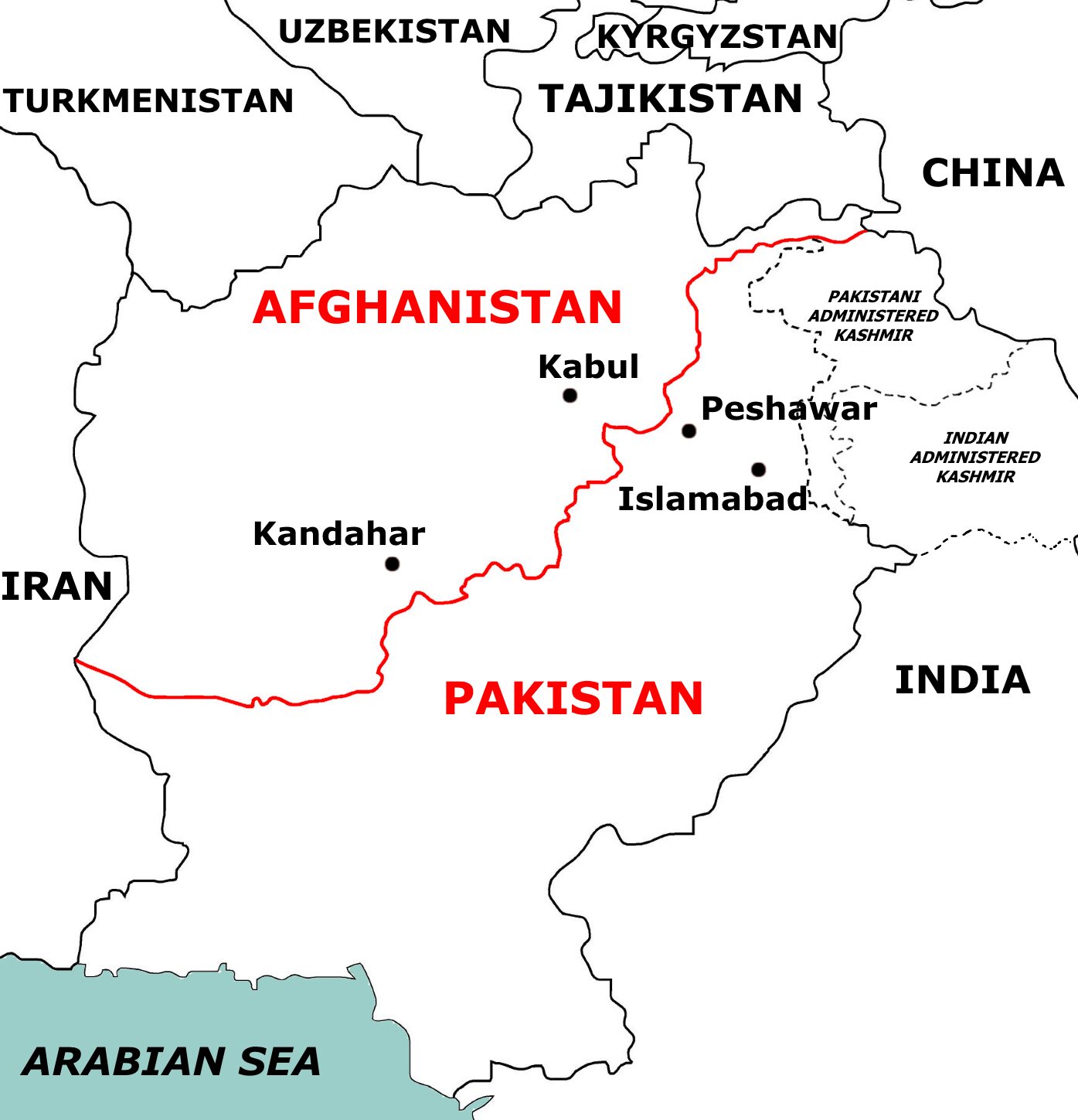
The Durand Line is one of the most contested borders in Asia, a 2,640 kilometre frontier that winds through the Hindu Kush, the Khyber Pass and the deserts of Baluchistan, separating modern Afghanistan from Pakistan. Drawn in 1893 by a British Indian civil servant and an Afghan Amir over a few sheets of paper in Kabul, it sliced the Pashtun homeland in two and set the stage for more than a century of insurgency, covert war, refugee flows and great power rivalry. No Afghan government, from King Amanullah to the current Taliban regime, has ever formally accepted it as an international boundary.
For Indian diplomacy the Durand Line is not a bilateral spat between two neighbours. It shapes Pakistan’s western security calculus, influences Islamabad’s behaviour in Kashmir, hosts the Taliban and the Tehrik-i-Taliban Pakistan, and determines connectivity routes to Central Asia through Chabahar and the International North South Transport Corridor. For UPSC aspirants preparing GS2 international relations and GS3 internal security, the Durand Line is a compact case study in colonial cartography, ethnic geography, failed state building and current affairs from the 2021 Taliban takeover to the 2024 fencing dispute.
Quick Facts at a Glance
| Attribute | Detail |
|---|---|
| Length | Approximately 2,640 km |
| Year signed | 12 November 1893 |
| Signatories | Sir Henry Mortimer Durand and Amir Abdur Rahman Khan |
| Location of signing | Kabul |
| Ethnic group split | Pashtuns (and Baloch) |
| Pakistani provinces on border | Khyber Pakhtunkhwa and Balochistan |
| Afghan provinces on border | Nangarhar, Kunar, Paktia, Paktika, Khost, Helmand, Kandahar |
| Afghan position | Does not recognise the line |
| Pakistani position | Settled international boundary |
| Key passes | Khyber, Tochi, Gomal, Bolan |
Background and Historical Context
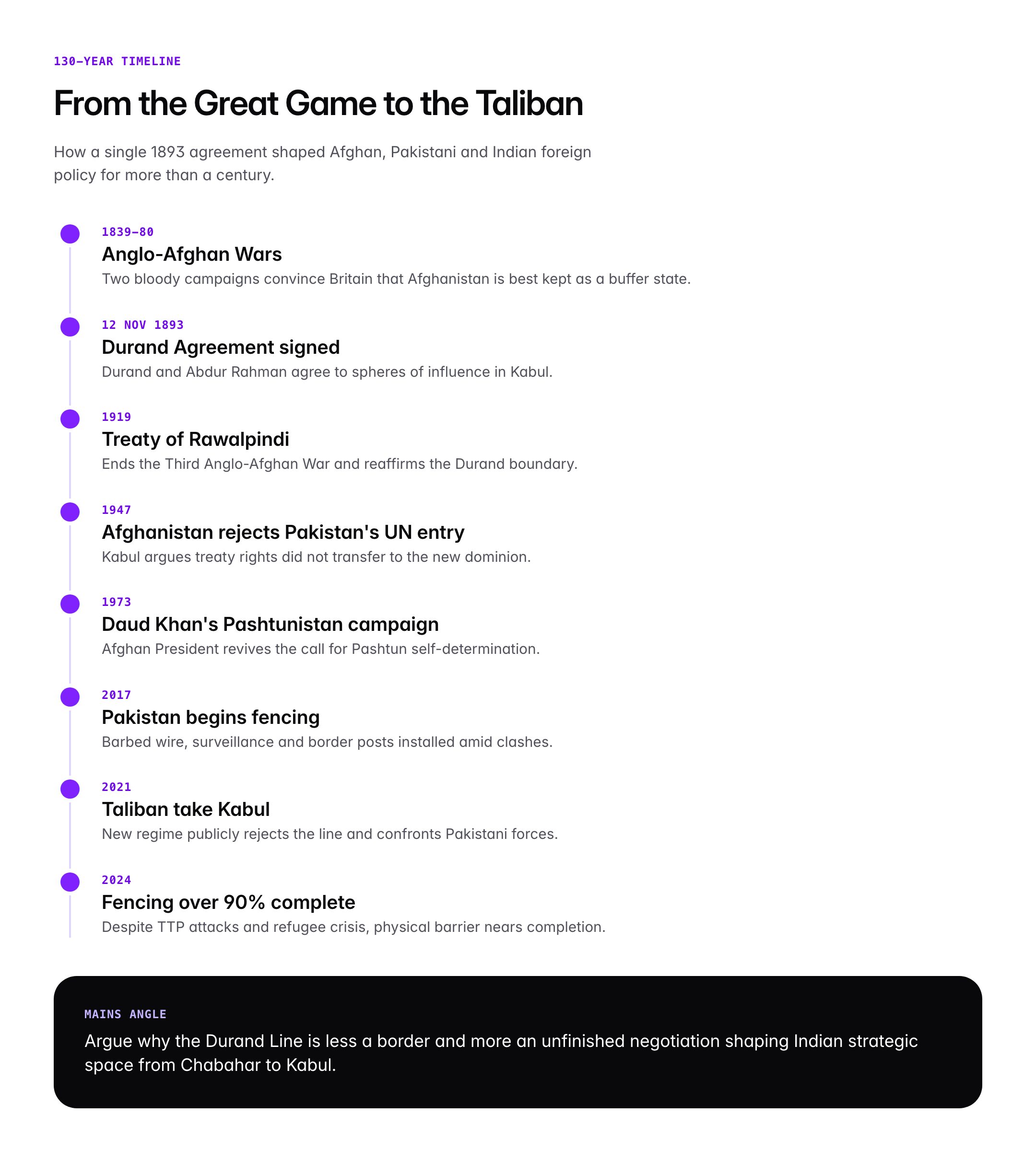
By the late 19th century, British India and Tsarist Russia were locked in the Great Game, a contest of influence over Central Asia and Afghanistan. Two Anglo-Afghan wars (1839-42 and 1878-80) had bloodied British expeditions and convinced London to treat Afghanistan as a buffer state rather than a territory to be annexed. After the Treaty of Gandamak (1879) and subsequent negotiations, Amir Abdur Rahman Khan, known as the Iron Amir, was accepted by the British as the consolidator of Afghan statehood in exchange for an annual subsidy and surrender of foreign policy.
Border questions remained unsettled. Tribal areas in what is today Khyber Pakhtunkhwa, the Federally Administered Tribal Areas and Balochistan were raided from both sides. In 1893, Sir Henry Mortimer Durand, Foreign Secretary of the Government of India, travelled to Kabul to negotiate a demarcation. On 12 November 1893, he and Amir Abdur Rahman signed a seven-article agreement establishing spheres of influence. A British-Afghan joint commission then demarcated the line on the ground between 1894 and 1896.
Abdur Rahman agreed because of his weakened military position and the promise of an increased annual British subsidy from 1.2 million rupees to 1.8 million rupees. In his own memoirs he later recorded reservations that the line separated tribes that had always been under Kabul’s cultural orbit. After his death in 1901, successive Afghan rulers contested the agreement’s durability.
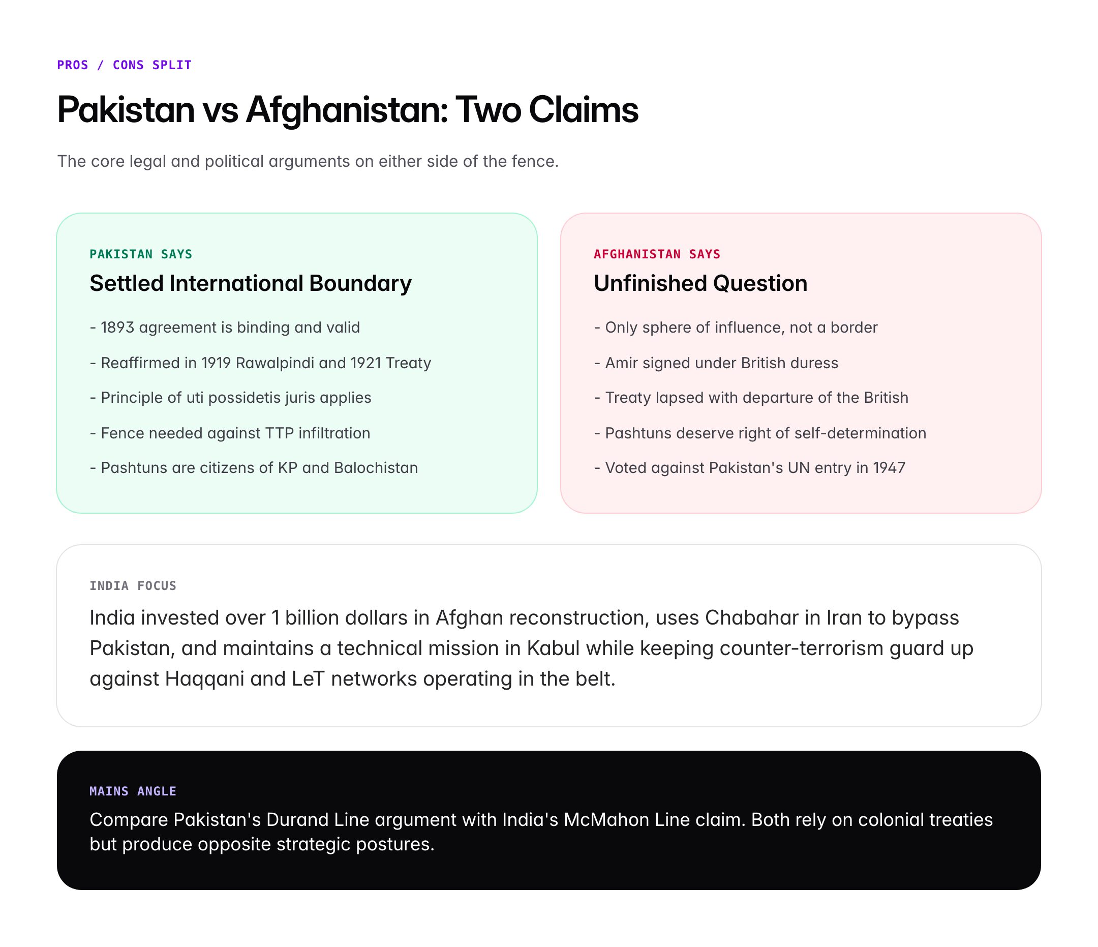
In 1919, after the Third Anglo-Afghan War and the Treaty of Rawalpindi, Afghanistan regained full control of its foreign policy. The 1921 Anglo-Afghan Treaty reaffirmed the 1893 boundary. When Pakistan was born in August 1947, Afghanistan was the only member state to vote against its admission to the United Nations, arguing that the Durand Line treaty had lapsed with the departure of the British and that Pashtun areas should be allowed to choose between joining Afghanistan, independence as Pashtunistan, or Pakistan. Islamabad rejected the argument and the dispute has smouldered ever since.
Key Features and Geography
Physical Geography
The Durand Line runs through some of the most rugged terrain on earth. Starting from the trijunction with China near the Wakhan Corridor in the north, it descends through the Hindu Kush mountains, crosses the Khyber Pass, traverses the Safed Koh and Sulaiman ranges, and ends at the Koh-i-Malik Siah where Iran, Afghanistan and Pakistan meet. Altitudes range from over 4,800 metres at alpine passes to the arid plains of Chaghai in Balochistan.
Four historic passes puncture the line, each carrying strategic weight. The Khyber Pass (1,070 metres) is the busiest, linking Peshawar with Jalalabad and Kabul. The Tochi Pass connects North Waziristan with Ghazni. The Gomal Pass in South Waziristan was historically used by Powindah nomadic traders. The Bolan Pass in Balochistan, though slightly south of the line, is the gateway to Quetta and Kandahar.
Human Geography
The line splits the Pashtun ethnic homeland. An estimated 50 to 60 million Pashtuns live on both sides, with roughly 35 million in Pakistan and 15 to 18 million in Afghanistan. Pashtuns share language (Pashto), tribal structures (Khyber, Yusufzai, Afridi, Waziri, Mahsud, Mohmand, Shinwari, Ghilzai, Durrani), customary law (Pashtunwali) and, largely, Sunni Hanafi Islam. The line also cuts through Baloch populations in the south, though Baloch nationalism is a separate issue focused on Balochistan and Iranian Sistan.
Legal Character
Pakistan considers the Durand Line a fully settled international boundary inherited under the principle of uti possidetis juris from its British Indian predecessor. It points to the 1893 agreement, 1905 reaffirmation under Amir Habibullah, 1919 Treaty of Rawalpindi, 1921 treaty and 1930 exchange of notes. Afghanistan and many Afghan legal scholars argue that the 1893 agreement created only a sphere of influence, that the Amir signed under duress, and that British treaty rights could not automatically transfer to a successor state created by partition.
Contemporary Fencing
Since 2017, Pakistan has been constructing a barbed wire fence along most of the Durand Line, supported by border posts and surveillance. As of 2024 over 90 per cent of the fence was reported complete despite repeated Afghan protests and periodic armed clashes, especially in Kunar, Nangarhar and Paktika provinces.
Significance for UPSC and General Knowledge
- Classic case for GS2 on colonial legacies shaping post-colonial disputes.
- Connects to GS1 world geography through passes, ranges and ethno-linguistic distribution.
- Offers a lens on Pakistan’s internal security given the link between the Afghan border and the TTP.
- Illustrates the doctrine of uti possidetis juris relevant to India’s own border questions with China.
- Prelims factual territory: 1893 date, Durand and Abdur Rahman, length, countries, passes.
- Ties to India’s strategic interests via Chabahar, INSTC, and outreach to the Taliban regime post-2021.
Detailed Analysis: Strategic Importance for India
The Durand Line matters to India for three interlocking reasons. First, it defines Pakistan’s two-front anxiety. So long as Islamabad views its western border as contested and its eastern border with India as hostile, it maintains a military doctrine demanding parity with India while diverting resources to tribal areas. This has pushed successive Pakistani governments towards support for proxy groups, starting with the mujahideen of the 1980s and continuing with the Taliban of the 1990s and 2000s.
Second, the Durand Line is the geographic address of terror infrastructure affecting India. Groups like Lashkar-e-Taiba and Jaish-e-Mohammed, though directed against India, have historically drawn sanctuary, training and ideological reinforcement from the Afghanistan-Pakistan belt. The Haqqani Network, which carried out the 2008 attack on the Indian embassy in Kabul killing 58 people including Brigadier Ravi Datt Mehta and Counsellor V Venkateswara Rao, operates from Pakistan-side tribal areas.
Third, the Durand Line is central to India’s connectivity ambitions. New Delhi has invested roughly one billion dollars in Afghan reconstruction since 2001, built the Zaranj-Delaram highway, the Salma Dam in Herat, and the Afghan parliament building. To sustain this outreach without going through Pakistan, India developed the Chabahar Port in Iran under a long-term contract signed in May 2024, bypassing Pakistani territory to reach Central Asia through Afghanistan’s Milak crossing.
The Taliban takeover in August 2021 altered the calculus. The new Afghan regime has publicly rejected the Durand Line, staged military clashes with Pakistani forces in Chaman, Torkham and Kurram, and expelled Afghan refugees. For India, this opens limited engagement space with Kabul through humanitarian assistance and residual development projects, while keeping counter-terrorism guard up given the 2023 resurgence of TTP and ISKP attacks inside Pakistan and spillover risks across the region. India reopened a technical mission in Kabul in 2022 and has maintained a calibrated dialogue without formal recognition of the Taliban government.
Comparative Perspective
Colonial boundary-making left similar contested lines across Asia and Africa. Comparing them helps appreciate the Durand Line’s distinctive features.
| Line | Year | Drawn By | Status Today |
|---|---|---|---|
| Durand Line | 1893 | Durand and Abdur Rahman | Contested by Afghanistan |
| McMahon Line | 1914 | Simla Convention | Contested by China |
| Radcliffe Line | 1947 | Cyril Radcliffe | Accepted in parts, contested in Kashmir |
| Sykes-Picot | 1916 | Britain and France | Modified over decades |
| Mortimer Durand style | Late 19th c | British cartographers | Common in colonial Asia |
Unlike the McMahon Line, where India claims treaty validity while China contests, in the Durand Line Pakistan plays the role India does on the McMahon Line, arguing inherited treaty rights against a neighbour that disputes colonial-era instruments. This parallel offers useful Mains material on comparative colonial cartography.
Challenges and Debates
The primary challenge is the lack of Afghan recognition, which makes the Durand Line a latent rather than settled border. Every Afghan political formation from the 1923 Loya Jirga to Mohammed Daud Khan’s 1970s Pashtunistan campaign to the present Taliban foreign ministry has refused to accept the line as final. This rejection fuels Pakistan’s insecurity and explains its long reliance on religious militancy as a strategic instrument.
The humanitarian dimension is significant. The line separates families, tribes and markets. Traditional trans-frontier trade, pastoralism and marriage ties face daily friction from fencing, visa regimes and customs. Over 3 million Afghan refugees in Pakistan, many Pashtun, became pawns in the 2023 mass deportation drive. The Pashtun Tahafuz Movement in Pakistan has sought civil rights for Pashtun citizens while rejecting both secession and the status quo.
Environmental and livelihood challenges include cross-border water sharing on the Kabul river, smuggling of narcotics and goods, and the impact of fencing on wildlife corridors for the Markhor and Snow Leopard. A further debate concerns the role of external powers. China’s expansion of the China-Pakistan Economic Corridor into Gwadar and potentially into Afghanistan through the Wakhan, and the United States’ post-withdrawal leverage, both intersect with the Durand Line question.
Prelims Pointers
- The Durand Line was signed on 12 November 1893 in Kabul.
- Signatories were Sir Henry Mortimer Durand and Amir Abdur Rahman Khan.
- Approximate length of the boundary is 2,640 kilometres.
- The line was demarcated on ground by a joint commission between 1894 and 1896.
- The Treaty of Rawalpindi (1919) ended the Third Anglo-Afghan War and reaffirmed the boundary.
- Afghanistan voted against Pakistan’s UN admission in 1947 citing the Durand Line.
- The Khyber, Tochi, Gomal and Bolan passes traverse or lie close to the line.
- Pakistan has fenced over 90 per cent of the Durand Line since 2017.
- The line splits the Pashtun ethnic homeland across two states.
- Pashtunwali is the customary code of conduct of Pashtuns on both sides.
- India’s Chabahar port in Iran is its primary connectivity bypass of Pakistan.
- The 2008 Indian embassy attack in Kabul was conducted by the Haqqani Network.
Mains Practice Questions
- “The Durand Line is less a border than an unfinished negotiation.” Critically examine the statement with reference to Afghan-Pakistan relations and its implications for Indian strategic interests. (15 marks, 250 words)
- Outline 1893 agreement, Amir’s reservations and successive Afghan rejections.
- Analyse the security consequences: safe havens, TTP, Haqqani Network, 2021 Taliban return.
- Connect to India’s policy of engagement with Kabul, Chabahar and INSTC investments.
- “Colonial boundaries in Asia continue to shape contemporary security dilemmas.” Illustrate with the Durand Line and the McMahon Line. (10 marks, 150 words)
- Contrast origin, signatories and status under international law.
- Compare Pakistan’s uti possidetis argument on Durand with India’s on McMahon.
- Conclude on lessons for negotiated settlement of historical boundaries.
Conclusion
The Durand Line is a line on a map, but it is also a line through a people. For 130 years it has divided Pashtun tribes, complicated South Asian security and shaped the foreign policy of Kabul, Islamabad and Delhi. What began as a 1893 compromise between an imperial foreign secretary and an Iron Amir has become the fulcrum on which questions of sovereignty, identity, and statecraft turn.
For India, the Durand Line is a reminder that its own security is never purely a bilateral matter with Pakistan; it is conditioned by Kabul, Tehran and Beijing as well. For the aspirant, the line offers an unusually rich case on colonial cartography, ethnic geography and contemporary strategy, linking GS1 geography, GS2 international relations and GS3 internal security in a single, consequential frontier.
Frequently Asked Questions
What is the Durand Line?
The Durand Line is the 2,640 kilometre international border between Afghanistan and Pakistan. It was drawn on 12 November 1893 through an agreement between Sir Henry Mortimer Durand, Foreign Secretary of British India, and Amir Abdur Rahman Khan of Afghanistan. The line runs through the Hindu Kush, crosses the Khyber Pass and ends near the Iran border, splitting the Pashtun ethnic homeland between two modern states.
Why is the Durand Line important for UPSC?
The Durand Line is a staple GS2 topic linking colonial legacies, international boundaries and South Asian security. It connects to GS1 geography through passes and ethnography, GS3 internal security through cross-border terrorism, and current affairs via the 2021 Taliban takeover. Prelims often asks about the year, signatories and length, while Mains uses it to assess colonial cartography and India’s Afghan policy.
How is the Durand Line related to the Pashtun issue?
The Durand Line cuts through the heart of the Pashtun homeland, separating an estimated 35 million Pashtuns in Pakistan from 15 to 18 million in Afghanistan. Pashtuns on both sides share Pashto language, tribal structures and the Pashtunwali code. Afghan governments have historically championed Pashtunistan, while Pakistan treats Pashtuns as citizens of Khyber Pakhtunkhwa and Balochistan. The division fuels separatist sympathies and complicates border management.
Who signed the Durand Line Agreement?
The Durand Line Agreement was signed on 12 November 1893 in Kabul by Sir Henry Mortimer Durand, the Foreign Secretary of the Government of British India, and Amir Abdur Rahman Khan, the ruler of Afghanistan known as the Iron Amir. The agreement was seven articles long and created spheres of influence that were subsequently demarcated on the ground by a joint commission between 1894 and 1896.
Does Afghanistan recognise the Durand Line?
No. No Afghan government since 1947 has formally recognised the Durand Line as an international border. Afghanistan was the only country to vote against Pakistan’s admission to the United Nations in 1947 on this issue. The current Taliban regime has publicly rejected the line and clashed with Pakistani forces at Chaman, Torkham and Kurram, while opposing Pakistan’s ongoing fencing of the border.
What is the strategic importance of the Durand Line for India?
The Durand Line shapes Pakistan’s two-front military posture, hosts terror infrastructure that has targeted Indian missions in Kabul, and influences connectivity routes to Central Asia. India has responded by investing over one billion dollars in Afghan reconstruction, developing Chabahar port in Iran to bypass Pakistan, and joining the International North South Transport Corridor. The Taliban’s rejection of the line gives Delhi limited space for calibrated engagement.
What are the key passes on the Durand Line?
Four historic passes carry traffic across or near the Durand Line. The Khyber Pass links Peshawar with Jalalabad and Kabul. The Tochi Pass connects North Waziristan with Ghazni. The Gomal Pass in South Waziristan was used by Powindah nomads. The Bolan Pass, slightly south of the line in Balochistan, is the gateway to Quetta and Kandahar. These passes have defined invasions, trade and tribal movements for centuries.
Why did Abdur Rahman Khan agree to the Durand Line?
Amir Abdur Rahman Khan signed the 1893 agreement due to military and financial constraints. He had just consolidated internal rule after suppressing revolts and lacked the capacity to confront British India. In return he secured an increase in the annual British subsidy from 1.2 million to 1.8 million rupees and recognition as the sovereign of Afghanistan. His memoirs record reservations that the line separated tribes loyal to Kabul.