Indian Climate: Koppen Classification & Climatic Regions
Complete guide to Koppen climate classification applied to India covering Amw, Aw, BShw, BWhw, Cwg, Dfc, ET, and H types with Trewartha modification and IMD classification for UPSC.
Wladimir Koppen introduced his climate classification in 1918, revised in 1936, based on monthly and annual averages of temperature and precipitation. India, stretching from 8°4'N to 37°6'N latitude and from sea level to 8,586 m (K2), hosts nearly every major Koppen climate type. UPSC has repeatedly tested this in Prelims and GS-I Mains, most recently asking candidates to match climatic types with their Indian regions.
The system uses capital letters (A, B, C, D, E) for major groups and lowercase letters for sub-types based on precipitation seasonality and temperature thresholds. Understanding this framework is non-negotiable for Geography optional and GS-I.
Koppen Classification: The Framework
Koppen divided world climates into 5 major groups:
- A — Tropical (coldest month >18°C)
- B — Dry (evaporation exceeds precipitation)
- C — Warm Temperate (coldest month between -3°C and 18°C)
- D — Cold (coldest month below -3°C, warmest month >10°C)
- E — Polar (warmest month below 10°C)
The second letter indicates precipitation pattern: f (no dry season), m (monsoon), w (dry winter), s (dry summer). The third letter indicates temperature: h (hot), k (cold), a/b/c (summer temperature gradients).
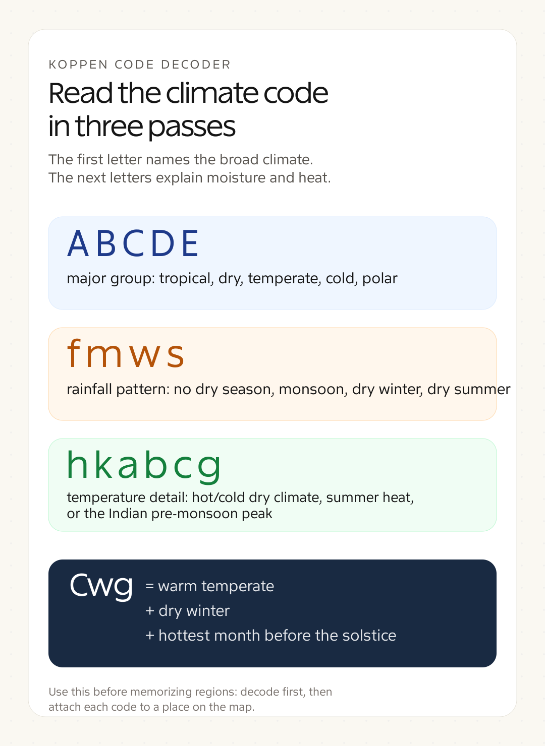
Common student mistake: Confusing Koppen's "B" group logic. Unlike other groups classified by temperature first, the B (dry) group is determined by a precipitation-temperature formula, not temperature alone. A place can be hot or cold and still fall under B if aridity dominates.
India's Koppen Climatic Regions
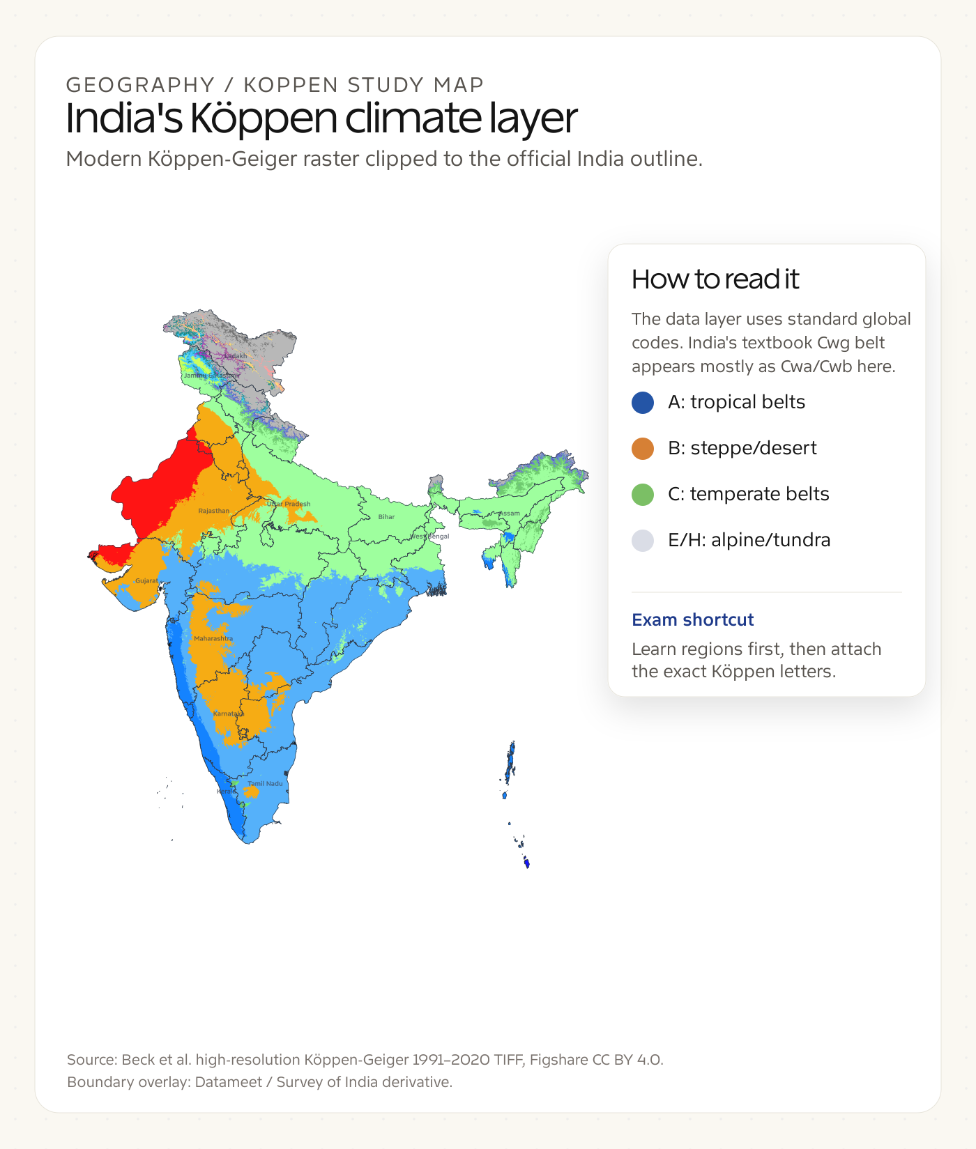
Use this map as a study layer, not a district-level atlas. The color raster follows modern global Koppen-Geiger notation, so North India's humid subtropical belt appears mostly as Cwa/Cwb in the data even though Indian textbooks often teach the Cwg modifier for the pre-monsoon heat peak.
Amw — Tropical Monsoon (Malabar Coast)
The Malabar Coast (Kerala, coastal Karnataka) receives 200-300+ cm rainfall annually, overwhelmingly during the southwest monsoon. The short dry season (December-February) distinguishes it from true equatorial (Af) climate. Mean temperature stays above 18°C year-round. Dense tropical evergreen forests thrive here with species like rosewood, mahogany, and ebony.
This region gets the earliest monsoon onset in mainland India, typically by June 1. The Western Ghats force orographic lifting of moisture-laden southwest monsoon winds, producing some of India's heaviest rainfall.
Aw — Tropical Savanna (Peninsular India)
Most of Peninsular India falls under this type. Distinct wet (June-September) and dry (November-April) seasons define the climate. Rainfall ranges from 100-200 cm, and temperatures remain above 18°C even in the coldest month.
This covers the Deccan Plateau, Tamil Nadu interior, eastern Maharashtra, Chhattisgarh, and Odisha. Tropical deciduous forests dominate, with teak and sal as flagship species. The long dry season promotes leaf-shedding, giving the landscape its characteristic seasonal transformation.
BShw — Semi-Arid Steppe
The rain shadow regions of India: parts of Rajasthan, Gujarat, western Maharashtra, interior Karnataka, and Telangana. Annual rainfall ranges from 40-75 cm. The "S" indicates steppe, "h" means hot (mean annual temperature >18°C), and "w" signals dry winter.
Thorn forests and scrubland characterize this zone. Babool (Acacia nilotica), khair, and drought-resistant grasses form the natural vegetation. This zone acts as a transition between the desert (BWhw) and the wetter savanna (Aw) regions.
BWhw — Hot Desert (Thar Desert)
The Thar Desert in western Rajasthan receives less than 25 cm annual rainfall. “W” signifies true desert (as opposed to steppe), with extreme diurnal temperature variation — summer days exceeding 50°C while winter nights can drop below 5°C.
Jaisalmer averages just 17 cm annual rainfall. The Aravalli Range, running NE-SW, fails to intercept the Arabian Sea branch of the monsoon effectively, leaving western Rajasthan parched. Sparse xerophytic vegetation includes cacti, thorny bushes, and Calligonum polygonoides (phog).
Cwg — Humid Subtropical with Dry Winter (North India)
The Gangetic Plain, Punjab, Haryana, eastern Rajasthan, and most of the Indo-Gangetic belt fall here. "C" indicates warm temperate, "w" means dry winter, and "g" signifies that the hottest month comes before the summer solstice (May, not June/July, because monsoon cooling arrives).
This is a distinctly Indian phenomenon — the "g" modifier was created specifically for the Indian subcontinent. Rainfall: 100-200 cm, concentrated in June-September. Winter temperatures in Delhi drop to 2-4°C (January mean ~14°C), while May peaks at 40-45°C.
Dfc — Cold Humid with Short Summer (High Altitude)
Found in Ladakh (lower valleys), parts of Sikkim, and Arunachal Pradesh at elevations above 3,000 m. Coldest month below -3°C, warmest month between 0-10°C. Precipitation is low, often as snow.
Leh records January mean of -7.8°C and July mean of 17.6°C. The short growing season (under 4 months) limits agriculture to hardy crops like barley and buckwheat. Coniferous forests of blue pine and birch grow at lower elevations within this zone.
ET — Tundra (Above Snowline)
Above the permanent snowline in the Greater Himalayas (typically above 4,500 m), the warmest month stays below 10°C. Vegetation is limited to mosses, lichens, and sparse alpine grasses. The Siachen Glacier region, upper Ladakh, and northern Sikkim fall here.
No month is warm enough for tree growth. Permafrost conditions prevail in many areas. This is India's most extreme climatic zone, where human habitation is virtually impossible without modern support systems.
H — Highland Climate
Koppen added this for mountainous regions where altitude creates compressed climate zones. The Himalayas exhibit tropical conditions at their base, temperate at mid-elevations, and polar at summits — all within a horizontal distance of 150-200 km.
The same mountain can host subtropical sal forests at 500 m, temperate oak-rhododendron forests at 2,000 m, coniferous forests at 3,000 m, alpine meadows (bugyals) at 3,500 m, and permanent snow above 5,000 m. Darjeeling at 2,042 m has a mean annual temperature of 15°C despite being at 27°N latitude.
Trewartha's Modification
Glenn Trewartha modified Koppen's system in 1968, arguing it was more applicable to tropical monsoon regions like India. Key changes:
- Raised the tropical (A) boundary to coldest month >18°C and annual rainfall >65 cm
- Distinguished between Am (monsoon with short dry) and Aw (savanna with long dry) more precisely
- Added a subtropical group (Cf) between tropical and temperate, better capturing regions like the middle Gangetic plain
- Used 6 major groups instead of 5, providing finer resolution for India's diverse climates
Trewartha's system places most of North India in the subtropical group rather than warm temperate, which geographers consider more climatically accurate.
IMD Classification: India's Official System
The India Meteorological Department (IMD) uses a simpler 4-season framework:
| Season | Months | Key Features |
|---|---|---|
| Winter (Cold Weather) | December – February | Western Disturbances bring rain to NW India; NE monsoon active in Tamil Nadu; lowest temperatures |
| Pre-Monsoon (Hot Weather/Summer) | March – May | Rising temperatures, loo winds in N India; thunderstorms (Nor'westers/Kal Baisakhi in Bengal, Mango showers in Kerala/Karnataka) |
| Southwest Monsoon | June – September | 75% of India's annual rainfall; onset Kerala (June 1), withdrawal from NW India (September) |
| Post-Monsoon (Retreating Monsoon) | October – November | Cyclonic activity in Bay of Bengal; NE monsoon gives rain to Tamil Nadu and SE coast |
IMD also classifies India into 4 broad climatic regions: Tropical Rainy, Tropical Semi-Arid, Tropical Arid, and Subtropical Humid. This is operationally useful but lacks the precision of Koppen for academic study.
Factors Affecting India's Climate
Seven factors determine why India hosts such climatic diversity:
- Latitude — Tropic of Cancer (23°30'N) divides India into tropical south and subtropical north
- Himalayan Barrier — Blocks cold Central Asian winds in winter, traps monsoon moisture in summer
- Monsoon Winds — Seasonal reversal of wind direction drives India's precipitation cycle
- Distance from Sea — Coastal regions (Mumbai: 12°C annual range) vs. interior (Delhi: 28°C annual range)
- Altitude — Every 165 m rise decreases temperature by ~1°C (normal lapse rate 6.5°C/km)
- Western Disturbances — Temperate cyclones from the Mediterranean bring winter rainfall to NW India (critical for rabi crops)
- Jet Streams — Subtropical westerly jet's position north or south of the Himalayas influences monsoon onset and withdrawal
Rainfall Distribution Across India
India's rainfall varies from 11,873 mm at Mawsynram (Meghalaya) to less than 100 mm in western Thar:
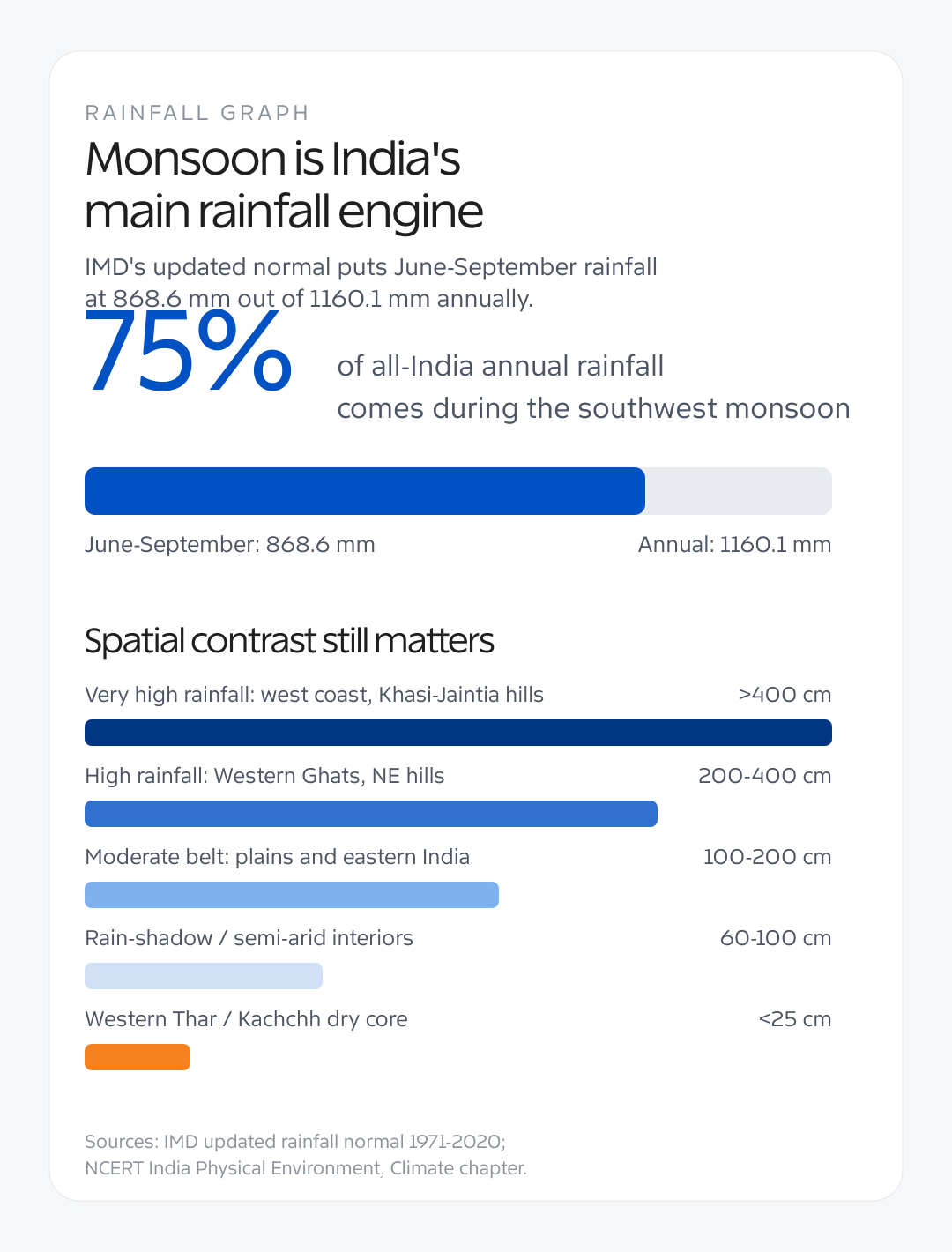
- >400 cm — Meghalaya hills, parts of Assam, western coast near Agumbe
- 200-400 cm — Western Ghats windward side, sub-Himalayan West Bengal, NE hills
- 100-200 cm — Eastern India, upper Gangetic plain, eastern Deccan
- 60-100 cm — Rain shadow areas, western Deccan, parts of Punjab
- <25 cm — Western Rajasthan (Thar Desert), Kachchh
Common student mistake: Assuming Tamil Nadu is a low-rainfall region. Chennai receives ~140 cm annually, but from the northeast monsoon (October-December), not the southwest monsoon. This is why it rains in Chennai when the rest of India is dry.
Koppen Climate Types in India: Summary Table
| Koppen Type | Climate Name | Indian Region | Annual Rainfall | Temperature Range | Vegetation |
|---|---|---|---|---|---|
| Amw | Tropical Monsoon | Malabar Coast (Kerala, coastal Karnataka) | 200-300+ cm | 24-32°C (low range) | Tropical Evergreen |
| Aw | Tropical Savanna | Most of Peninsular India | 100-200 cm | 20-40°C (seasonal) | Tropical Deciduous |
| BShw | Semi-Arid Steppe | Parts of Rajasthan, Gujarat, Karnataka | 40-75 cm | 22-42°C | Thorn Scrub |
| BWhw | Hot Desert | Western Rajasthan (Thar) | <25 cm | 5-50°C (extreme diurnal) | Xerophytic |
| Cwg | Humid Subtropical | Gangetic Plain, N India | 100-200 cm | 2-45°C (extreme annual) | Mixed Deciduous |
| Dfc | Cold Humid | Ladakh valleys, high Sikkim | 30-65 cm | -20 to 17°C | Coniferous |
| ET | Tundra | Above snowline, Greater Himalayas | Variable (snow) | -40 to 10°C | Mosses, Lichens |
| H | Highland | Entire Himalayan belt | Varies by altitude | Varies by altitude | Compressed zonation |
UPSC Relevance
UPSC Prelims 2015 asked about Koppen's classification criteria. Mains GS-I frequently tests "factors affecting Indian climate" and "why does western Rajasthan receive scanty rainfall." Geography Optional Paper-I (Climatology) demands detailed knowledge of Koppen, Trewartha, and Thornthwaite classifications.
The safest approach: memorize the 8 Indian Koppen types with their exact regions and at least 2 characteristics each. For Mains, connect climate to natural vegetation, agriculture, and human settlement patterns.