Introduction
The Panama Canal is the 82 kilometre artificial waterway that cuts the Isthmus of Panama and connects the Atlantic Ocean to the Pacific. Since its opening on 15 August 1914 it has reshaped global maritime trade by cutting the New York to San Francisco sea voyage from around 22,500 kilometres around Cape Horn to about 9,500 kilometres. For the UPSC aspirant it is a staple of world geography, international relations and trade questions: the canal features in GS1 physical geography, GS2 diplomacy and GS3 shipping and supply-chain chapters.
In 2026 the canal carries roughly 5 per cent of global seaborne trade and over 12,000 ocean-going transits a year, but it is also under stress. The 2023-24 drought in Gatun Lake forced the Panama Canal Authority to cut daily transits, and a new US administration in 2025 revived diplomatic pressure over tolls and Chinese port concessions. This article gives you a complete picture: the route, the engineering, the history from the French failure of the 1880s to the 2016 expansion, the economic footprint and why India and the Indo-Pacific care about this narrow stretch of water.
Quick Facts at a Glance
| Indicator | Value |
|---|---|
| Length | 82 km (51 miles) |
| Opened | 15 August 1914 |
| Location | Isthmus of Panama, Central America |
| Connects | Atlantic (Caribbean Sea) to Pacific Ocean |
| Lock system | Three sets of twin locks (Gatun, Pedro Miguel, Miraflores) plus post-2016 Neopanamax locks |
| Major lake | Gatun Lake (artificial, 425 sq km) |
| Transit time | 8 to 10 hours |
| Annual transits | Around 12,000 to 14,000 ocean vessels |
| Share of world trade | Approximately 5 per cent |
| Operator | Panama Canal Authority (ACP), autonomous since 1999 |
| Expansion opened | 26 June 2016 |
Background and Historical Context
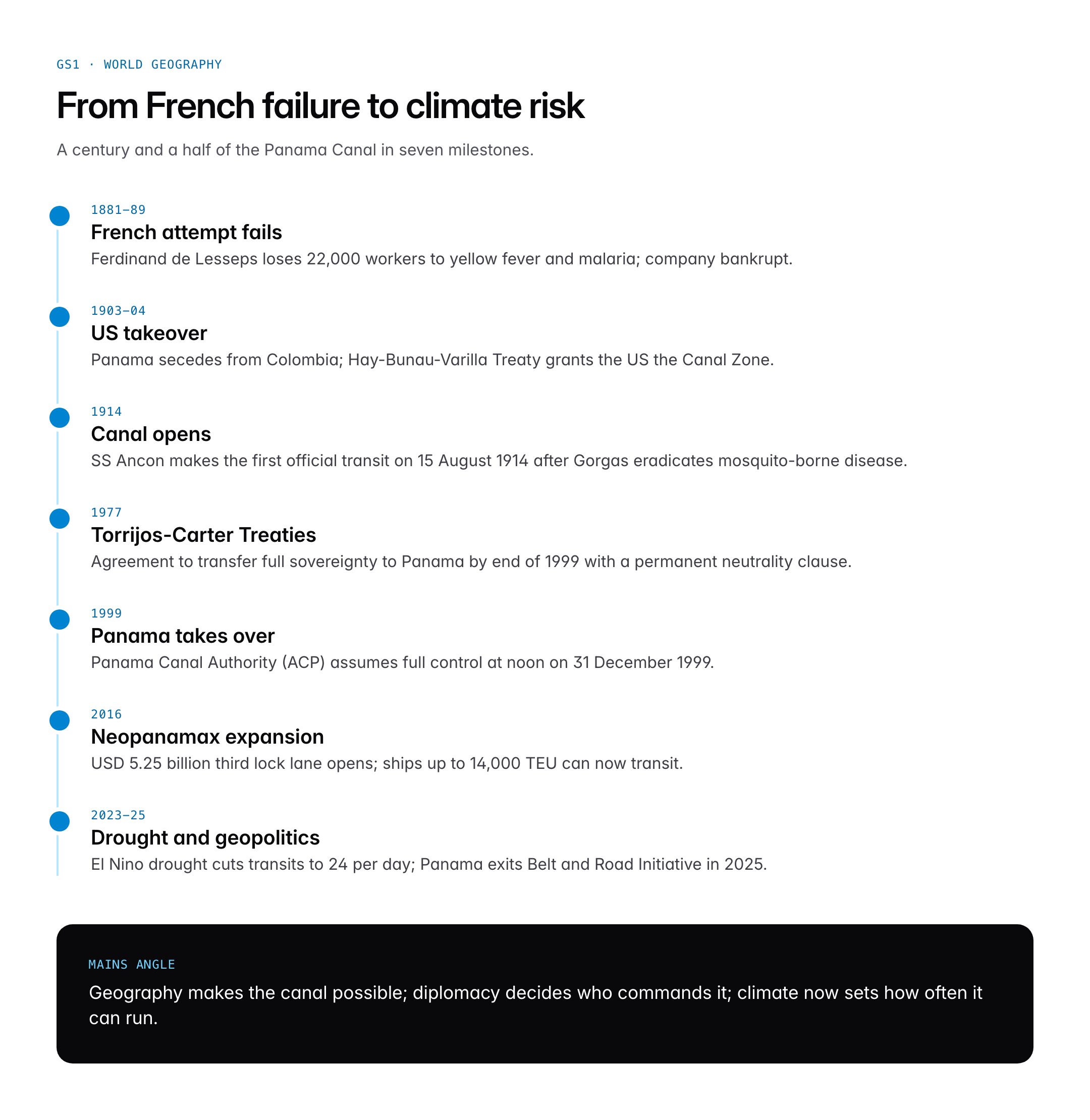
The idea of cutting a canal across the Isthmus of Panama dates to 1534 when Charles V of Spain ordered a survey. The first serious attempt came in 1881 when a French company led by Ferdinand de Lesseps, the builder of the Suez Canal, began a sea-level cut. Tropical disease, landslides and cost overruns bankrupted the company by 1889; an estimated 22,000 workers died, largely from yellow fever and malaria. A second French attempt under Philippe Bunau-Varilla also failed, and the assets were sold to the United States in 1904 for USD 40 million.
In 1903, following a US-backed secession of Panama from Colombia, the new Republic of Panama signed the Hay-Bunau-Varilla Treaty, granting the United States the Canal Zone in perpetuity. Chief engineer John Frank Stevens chose a lock-and-lake design over sea level. His successor George Washington Goethals completed construction in 1914. Disease control by chief sanitary officer William C. Gorgas, who eradicated mosquitoes carrying yellow fever and malaria, was the true enabling breakthrough.
US administration lasted until the Torrijos-Carter Treaties of 7 September 1977, which set a transition schedule. Full sovereignty passed to Panama at noon on 31 December 1999, and the Panama Canal Authority (Autoridad del Canal de Panama, ACP) has operated the waterway since. The Panama Canal Expansion Programme, approved by referendum in 2006 and completed at a cost of USD 5.25 billion, opened a third lane of Neopanamax locks on 26 June 2016, tripling the cargo capacity per transit.
Key Features of the Canal
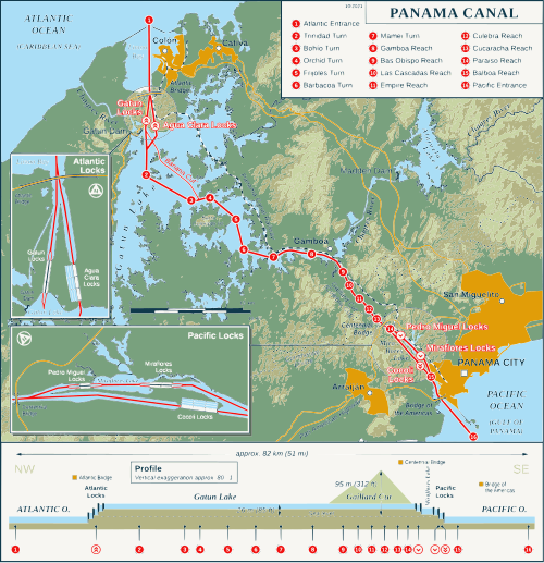
Route and Engineering
A vessel entering from the Atlantic side rises 26 metres through the Gatun Locks into Gatun Lake, the world’s largest artificial lake at the time of its creation. It then crosses the lake, enters the nine-mile Culebra Cut (also called Gaillard Cut) through the continental divide, descends one step at Pedro Miguel Lock and two more at Miraflores Locks into the Pacific. The original locks have two parallel chambers 33.5 metres wide and 305 metres long, taking ships up to Panamax size. The 2016 expansion added a third set of locks 55 metres wide and 427 metres long, big enough for Neopanamax vessels up to 14,000 TEU.
Water System and Gatun Lake
Unlike the sea-level Suez, the Panama Canal is gravity-fed from fresh water. Each transit of an original lock releases around 101 million litres of water into the ocean; Neopanamax locks use water-saving basins that recycle about 60 per cent but still consume hundreds of millions of litres per passage. Gatun Lake and Alajuela Lake together supply this water and also drinking water for Panama City. A severe El Nino linked drought in 2023-24 dropped Gatun Lake to historic lows, forcing the ACP to cut transits from 36 to 24 per day and to auction slots at premium tolls exceeding USD 2 million.
Traffic and Toll Structure
The canal handles bulk carriers (grain from the US Gulf to Asia), container ships (Asia to US East Coast), liquefied natural gas tankers (a post-2016 boom) and cruise vessels. Tolls are calculated on tonnage, cargo type and vessel category and were revised upward in 2023. Total toll revenue in fiscal year 2024 crossed USD 5 billion, contributing nearly 4 per cent of Panama’s GDP directly and much more through logistics and free-zone services at Colon.
Strategic Alternatives
Competing routes include the longer Suez Canal (193 km, sea-level, no locks), the Cape of Good Hope route around Africa, the Northwest Passage emerging in the Arctic due to ice retreat, and the proposed but dormant Nicaragua Canal. The 2023 Houthi attacks in the Red Sea diverted Asia-Europe traffic to the Cape, increasing relative importance of Panama for Asia-US East Coast flows.
Significance for UPSC and General Knowledge
- GS1 world geography: the canal is a classic example of modifying physiography through lock-and-lake engineering across a continental divide.
- GS2 international relations: US-Panama relations, the Torrijos-Carter Treaties, and the 2025 controversy over Chinese port concessions are testable.
- GS3 trade and logistics: the canal ranks alongside Suez, the Strait of Hormuz, Bab el-Mandeb and the Malacca Strait as a world choke-point.
- Current affairs: the 2023-24 drought, climate adaptation and ACP water-sharing with Panama City are recurring themes.
- Prelims map: aspirants should mark Panama, Colombia, Costa Rica and Gatun Lake on an outline map of Central America.
- Essay and interview: the canal is a case study in engineering, public health (yellow fever eradication) and decolonisation.
Detailed Analysis: Economic and Geopolitical Footprint
The Panama Canal shrinks voyage distances on several major trade lanes. A vessel from New York to San Francisco saves around 13,000 kilometres compared with the Cape Horn route. An LNG tanker from the US Gulf to Tokyo saves around 8,000 kilometres against the Cape of Good Hope alternative. Around 40 per cent of US container traffic and the majority of US-Gulf LNG exports to East Asia transit Panama, while on the other side 20 per cent of Chilean and Peruvian agricultural exports to Europe and Asia use the canal. Any disruption cascades into freight rates, food prices and factory schedules on both sides of the Pacific.
Geopolitically, Panama’s 1999 takeover turned the canal into a neutral global utility under the 1977 treaty’s neutrality clause. US concern since 2020 has centred on Chinese state-owned enterprises operating the Balboa and Cristobal container ports at either end of the canal and on Hong Kong-based CK Hutchison’s port concession. In early 2025 the US-Panama dialogue resulted in Panama withdrawing from the Belt and Road Initiative and reviewing the port concession, while BlackRock led a consortium that agreed to purchase the Hutchison ports. India follows the debate because a significant share of its pharmaceuticals and textile exports to the US East Coast, and its LNG imports from the US, pass through the canal.
Climate change is now the canal’s biggest systemic risk. Rainfall in the Gatun catchment has decreased in four of the past seven years. The ACP is studying a Rio Indio reservoir scheme, desalination and sea-water locks to de-risk the water supply. Any fundamental redesign will require new legislation in Panama because the canal is constitutionally protected as a patrimony of the Panamanian state.
Comparative Perspective
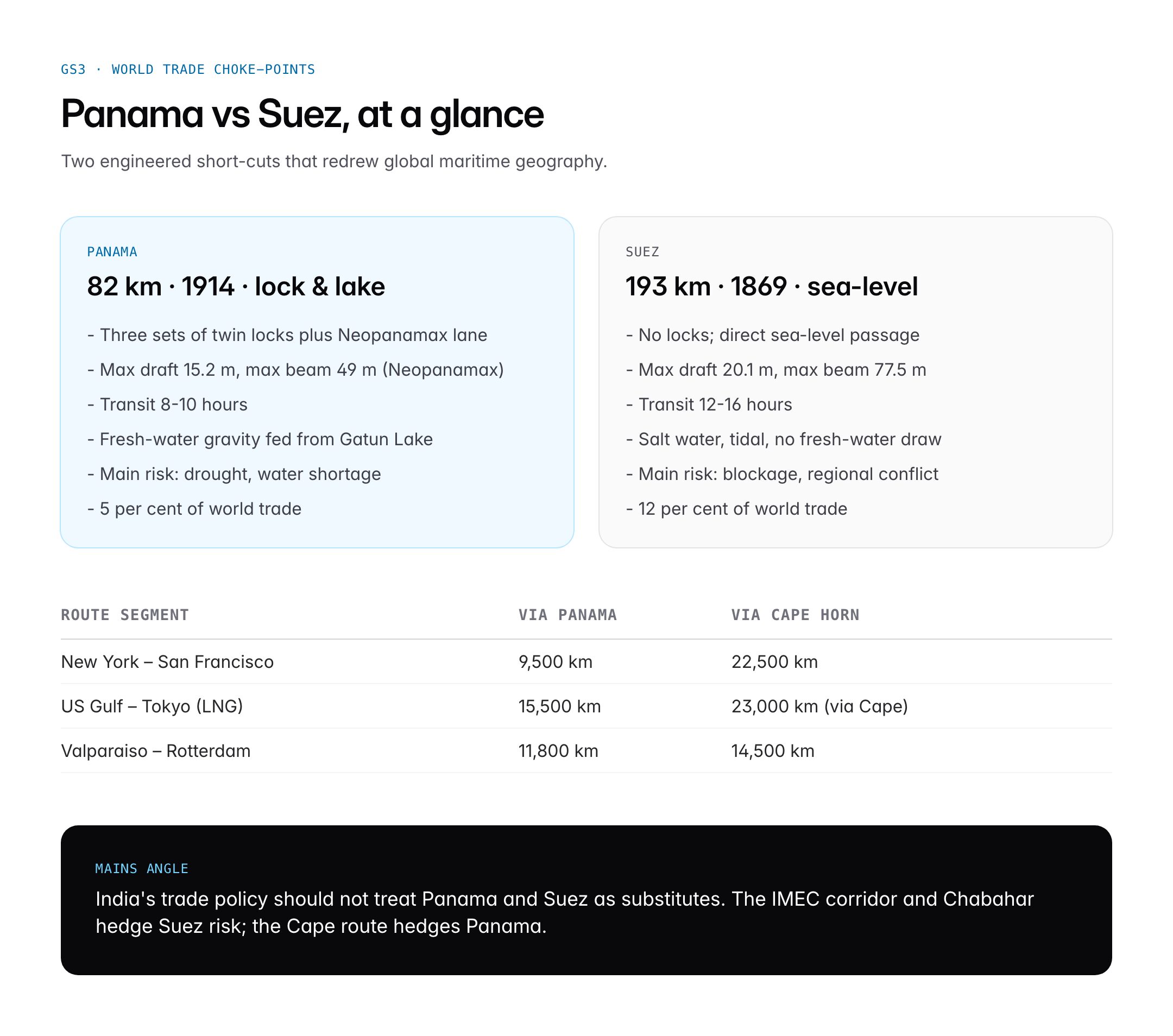
The two canals most often compared are Suez and Panama. The table below lays them side by side.
| Feature | Panama Canal | Suez Canal |
|---|---|---|
| Length | 82 km | 193 km |
| Design | Lock and lake (fresh water) | Sea-level (salt water) |
| Opened | 1914 | 1869 |
| Max vessel | Neopanamax (14,000 TEU) | Suezmax / VLCC |
| Transit time | 8 to 10 hours | 12 to 16 hours |
| Annual transits | 12,000-14,000 | ~19,000 |
| Share of world trade | ~5 per cent | ~12 per cent |
| Main risk | Drought, water shortage | Security, blockage (2021 Ever Given) |
| Operator | Panama Canal Authority | Suez Canal Authority, Egypt |
The two routes are complements more than substitutes: Panama dominates Pacific-Atlantic flows in the Americas, while Suez dominates Europe-Asia trade through the Indian Ocean.
Challenges and Criticisms
The Panama Canal faces three structural challenges. First, water scarcity under climate change threatens the gravity-fed lock system itself. Studies by the Smithsonian Tropical Research Institute indicate a high probability of more frequent drought years by mid-century. Second, competing routes — the Arctic Northwest Passage for shoulder seasons, the long-dormant Nicaragua Canal, and Belt-and-Road rail corridors from Chinese ports to European markets — could erode canal throughput in specific market segments. Third, geopolitical leverage over canal operations is contested between the United States, China and European shipping lines, with Panama striving to preserve its 1977 treaty neutrality.
Criticisms also persist over environmental costs. The creation of Gatun Lake submerged villages and rainforest, while lock discharges alter salinity in the Gulf of Panama. Labour questions about the 1904-14 construction era and the differential mortality of Caribbean workers remain part of Panama’s historical memory. Activists have pushed for reparations and commemorative recognition, and the canal authority now funds biodiversity and watershed conservation in the Chagres region.
Prelims Pointers
- The Panama Canal is 82 km long and was opened on 15 August 1914.
- It connects the Atlantic Ocean (Caribbean Sea) to the Pacific Ocean across the Isthmus of Panama.
- It uses a lock-and-lake system with Gatun Lake as the central reservoir.
- The Panama Canal Authority (ACP) has operated it since 31 December 1999 under the Torrijos-Carter Treaties 1977.
- William C. Gorgas eradicated yellow fever and malaria, enabling construction completion.
- Neopanamax locks opened on 26 June 2016 after a USD 5.25 billion expansion.
- Maximum Neopanamax beam is 49 metres; length is 366 metres; TEU capacity is about 14,000.
- The Panama Canal handles about 5 per cent of global seaborne trade.
- The 2023-24 drought reduced daily transits to around 24, forcing toll spikes.
- Panama’s neighbours are Colombia (east) and Costa Rica (west).
- The Culebra Cut slices through the continental divide of the Americas.
- Panama withdrew from the Belt and Road Initiative in 2025.
Mains Practice Questions
- “The Panama Canal is as much a climate vulnerability as it is a geopolitical asset.” Discuss in the light of the 2023-24 drought and renewed US interest. (250 words)
- Explain the lock-and-lake water dependence and 2023-24 transit cuts.
- Cover US-Panama dialogue since 2025 and port concession dynamics.
- Conclude with adaptation options and implications for world trade.
- Compare the Panama and Suez Canals as maritime choke-points and assess their implications for India’s trade policy. (250 words)
- Contrast engineering, geography and cargo mix.
- Map India’s LNG imports, pharma exports and container flows through each.
- Recommend diversification: Cape route, Chabahar, IMEC corridor.
Conclusion
The Panama Canal is a textbook example of how infrastructure, geography and diplomacy intersect. Built in 1914 by the United States on Colombia-turned-Panama soil, it was handed over to Panama in 1999, expanded in 2016 to fit modern mega-ships, and is now a climate-stressed asset at the centre of US-China rivalry in Latin America. Its 82 kilometres quietly move trillions of dollars worth of goods every year.
For the UPSC aspirant the canal is more than a map symbol. It is a case study in engineering ambition, public-health breakthrough, post-colonial sovereignty and climate vulnerability. Master its route, its lock system, its treaty history and its modern economics, and you can fluently handle questions across GS1, GS2 and GS3 and also use it as an example in essay writing.
Frequently Asked Questions
What is the Panama Canal?
The Panama Canal is an 82 kilometre artificial waterway across the Isthmus of Panama that connects the Atlantic Ocean with the Pacific. Opened on 15 August 1914, it uses a lock-and-lake system centred on Gatun Lake to lift and lower ships across the continental divide. It has been operated by the Panama Canal Authority since 31 December 1999.
Why is the Panama Canal important for UPSC?
The canal appears across GS1 world geography, GS2 international relations and GS3 trade. It anchors questions on maritime choke-points, colonial-era infrastructure, the Torrijos-Carter Treaties of 1977, climate-change impact on global trade, and US-China rivalry in Latin America.
How is the Panama Canal related to the Suez Canal?
Both are strategic man-made waterways, but Suez is a 193 km sea-level cut opened in 1869, while Panama is an 82 km lock-and-lake system opened in 1914. Suez dominates Europe-Asia trade; Panama dominates Atlantic-Pacific flows in the Americas. They are complements, not substitutes, and disruption in one raises freight volumes on the other.
How long does it take to transit the Panama Canal?
A typical transit takes 8 to 10 hours through three sets of locks and Gatun Lake. Ships queue in advance; slots can be auctioned during drought-restricted periods. The 2023-24 drought forced the Panama Canal Authority to cut daily transits from 36 to 24, raising average waiting time and tolls.
Who built the Panama Canal and when?
The first attempt was led by French engineer Ferdinand de Lesseps in 1881 but failed by 1889 due to disease and cost. The United States took over in 1904, with John Frank Stevens and George Washington Goethals as chief engineers and William C. Gorgas leading disease control. The canal opened on 15 August 1914.
What was the Panama Canal expansion of 2016?
Approved by a 2006 national referendum and completed in June 2016 at a cost of USD 5.25 billion, the expansion added a third set of Neopanamax locks measuring 55 by 427 metres. These accommodate container ships up to 14,000 TEU and large LNG tankers, roughly tripling the cargo capacity per transit.
How does the drought affect the Panama Canal?
The canal uses fresh water from Gatun and Alajuela Lakes to operate its locks, consuming hundreds of millions of litres per transit. Low rainfall in 2023-24 pushed Gatun Lake to historic lows, forcing transit caps, priority slot auctions and tolls that briefly exceeded USD 2 million per passage.
Why does India care about the Panama Canal?
A significant share of Indian pharmaceutical and textile exports to the US East Coast and LNG imports from the US Gulf transit the Panama Canal. Any congestion or toll spike feeds into Indian supply-chain costs, shipping insurance and energy prices, which is why the canal features in GS3 questions on global trade and energy security.