Silent Valley National Park: Save Silent Valley Movement, Lion-Tailed Macaque, Kerala
Silent Valley National Park in Kerala's Palakkad district, the rainforest core of the Nilgiri Biosphere Reserve, home to lion-tailed macaques and the Save Silent Valley movement legacy.
There are very few protected areas in India whose names double as a chapter heading in the country’s environmental history. Silent Valley is one of them. The forests in the upper Kunthipuzha basin in Kerala’s Palakkad district were the subject of a fifteen-year public campaign through the 1970s and 1980s that turned a hydro-electric project proposal into a national debate on biodiversity, indigenous rights, and the very idea of intrinsic ecological value. The campaign won. The dam was shelved. The forest was notified as a national park in 1984. And the Save Silent Valley movement entered the curriculum as the founding case study of organised environmental activism in independent India.
Silent Valley sits at the southern end of the Nilgiri Hills, in Palakkad district, draped along the boundary of Kerala and Tamil Nadu. It forms the core of the Nilgiri Biosphere Reserve, the first such reserve declared in India. In 2012, the entire Western Ghats including Silent Valley was inscribed as a UNESCO World Heritage Site. The park is home to the lion-tailed macaque, one of the world’s most endangered primates, along with a long roster of endemic Western Ghats species that exist almost nowhere else.
For UPSC, Silent Valley is more than a name on a national park list. It is a case study in environmental decision-making, in the politics of public interest litigation, and in the ecology of tropical rainforest at its global edge.
Quick Facts
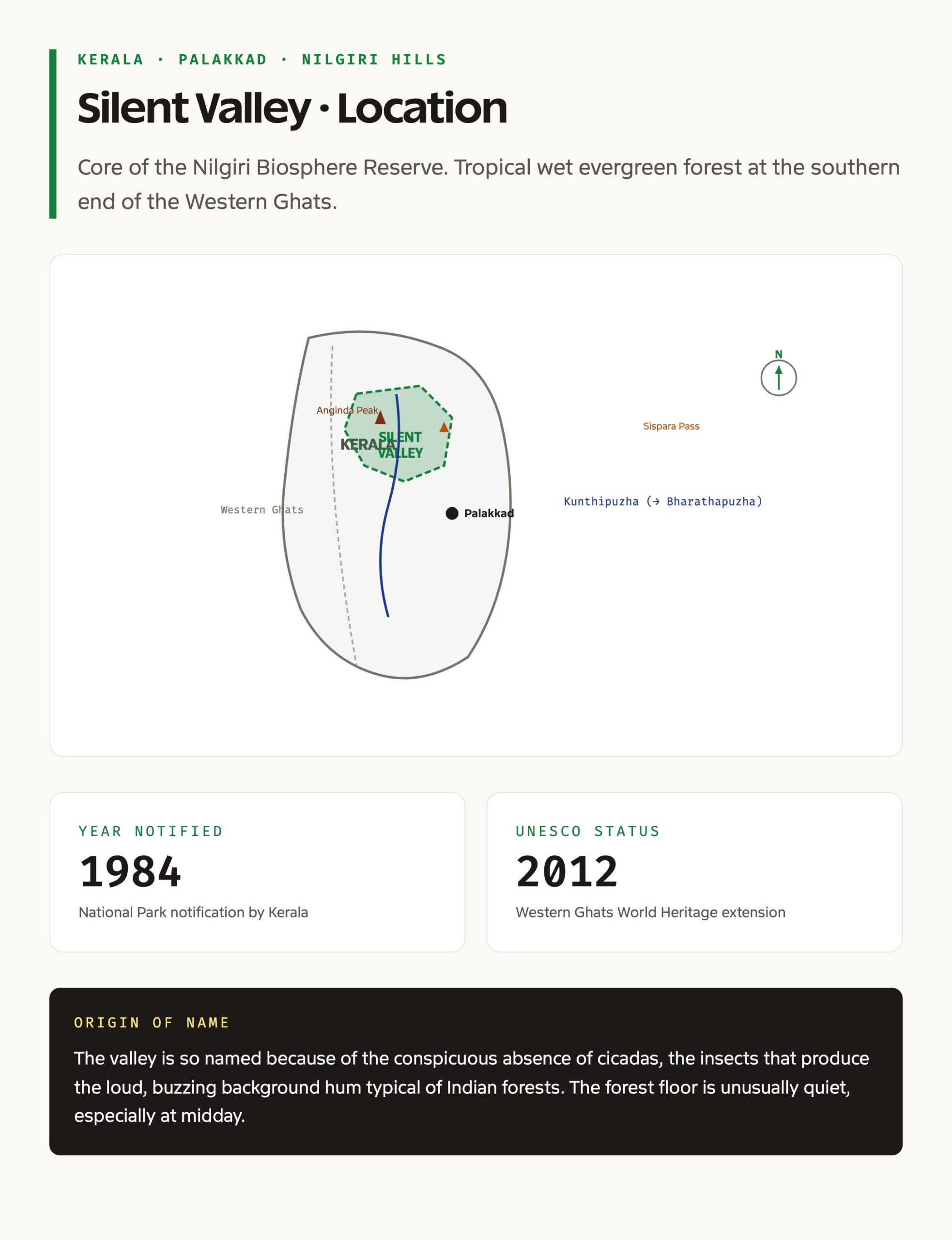
- Location: Palakkad district, Kerala, southern Western Ghats
- Within: Nilgiri Hills (southern extension)
- Notified as National Park: 1984
- Within: Nilgiri Biosphere Reserve, declared 1986
- UNESCO inscription: Western Ghats World Heritage Site, 2012
- Origin of name: Reportedly the absence of cicadas, the buzzing insects typical of Western Ghats forests
- Forest type: Tropical wet evergreen rainforest, primary forest
- Topography: Steep escarpments, high ridges, narrow valley floor
- Major river: Kunthipuzha, a tributary of the Bharathapuzha, originating within the park
- Iconic peaks and passes: Anginda Peak, Sispara Pass
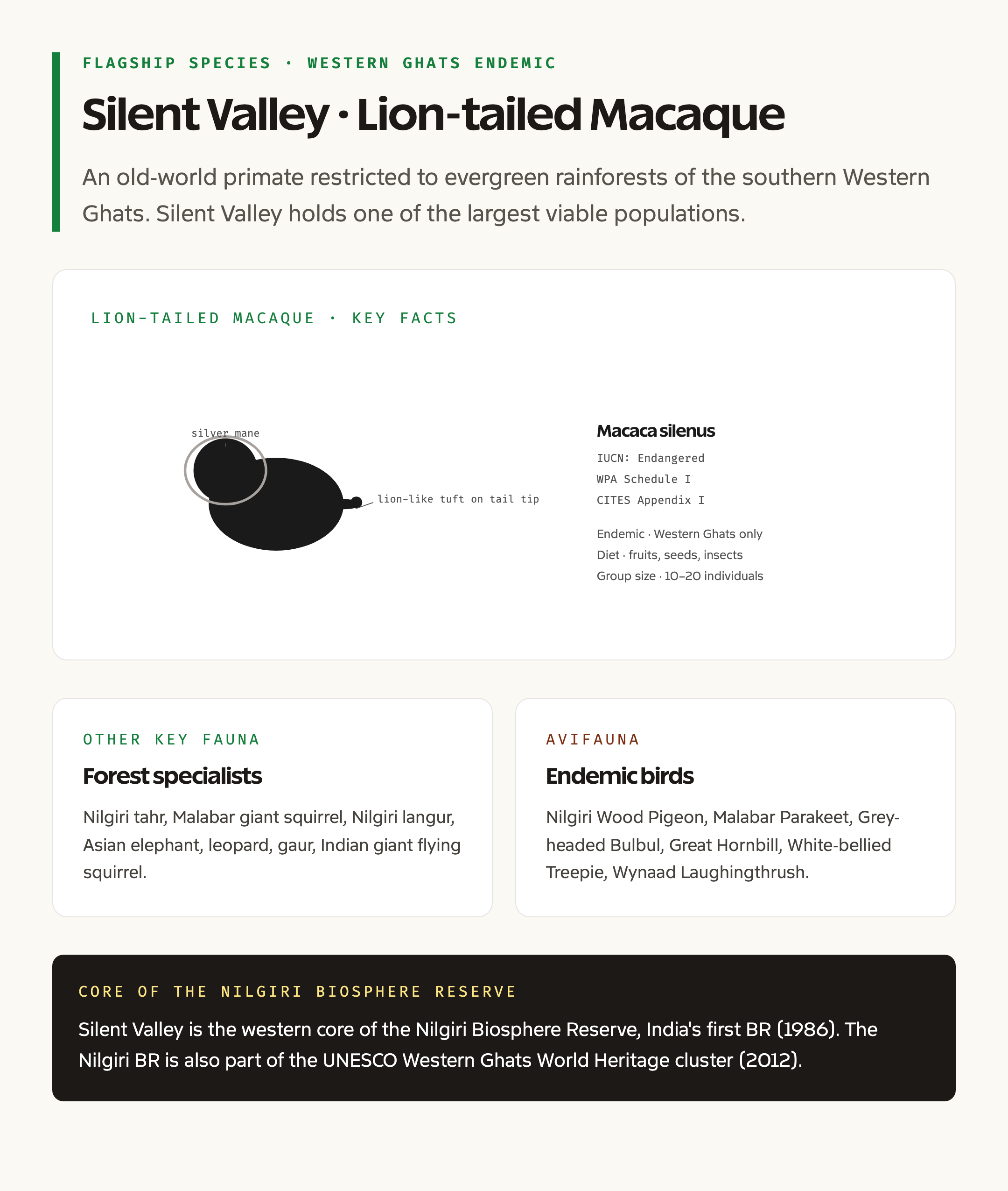
- Flagship species: Lion-tailed Macaque (Macaca silenus)
- Other key fauna: Nilgiri Wood Pigeon, Malabar Parakeet, Grey-headed Bulbul, Nilgiri tahr, Indian gaur, Malabar giant squirrel
- Prominent indigenous communities: Mudugar, Irula, Kurumba
- Cultural significance: Save Silent Valley Movement, 1970s to 1980s
- Conservation status: Among the last contiguous tracts of primary tropical evergreen forest in peninsular India
What Is Silent Valley National Park
Silent Valley is a comparatively compact protected area, about 237 sq km in core area, that punches well above its weight in biodiversity terms. The valley floor is the bed of the Kunthipuzha river, a perennial stream that rises from the upper slopes of the park and flows southwest through the valley before joining the Bharathapuzha system. The walls of the valley rise sharply on both sides, with Anginda Peak on the southern rim and Sispara Pass marking the northern edge.
The forest is overwhelmingly tropical wet evergreen, with several distinct strata. The emergent layer carries species like Cullenia exarillata and Mesua ferrea. The canopy is dense and interlocked, the understorey is shaded and humid, and the floor carries a continuous litter of decomposing leaves. Rainfall ranges between 3,000 and 6,000 millimetres a year depending on location, almost all of it concentrated in the southwest monsoon. The combination of altitude, rainfall, and uninterrupted forest creates one of the wettest, oldest, and most undisturbed rainforest ecosystems in the country.
The valley is largely free of internal human settlement, which is what makes it ecologically unusual. The buffer and the Attappadi region carry significant tribal populations, but the core has remained essentially uninhabited within the modern protected area boundary. This is a rare configuration in Indian conservation, where most parks have to manage residual human use inside the core.
Background and Historical Context
The Silent Valley story is best told in two halves. The first is the ecological pre-history of the forest itself. The second is the political history of the Save Silent Valley movement.
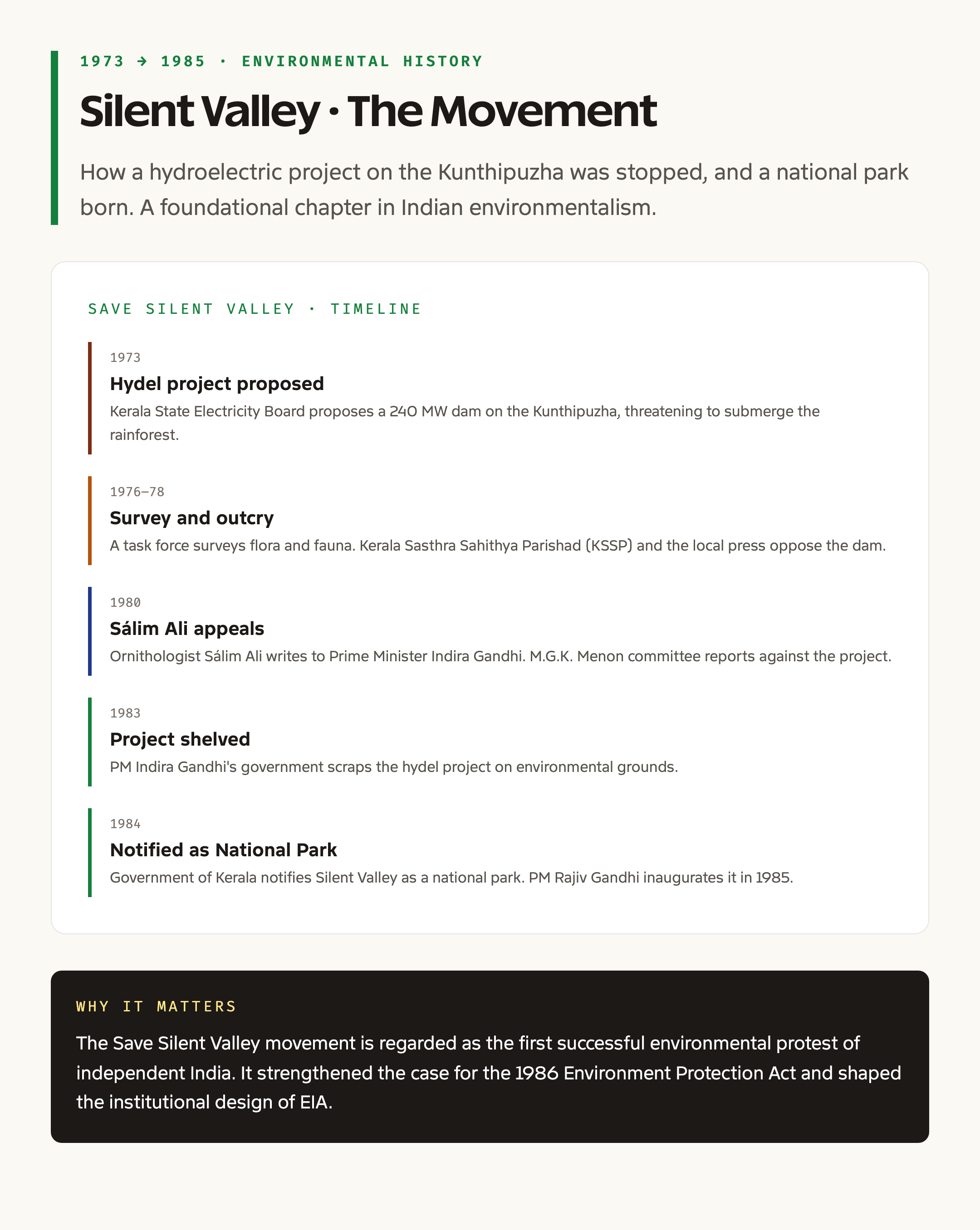
The forests of the upper Kunthipuzha basin appear in nineteenth-century botanical surveys as remarkable for their intact canopy and high endemism. They escaped the heaviest commercial logging of the colonial period because of their inaccessibility and steep terrain. By the 1960s, the Kerala State Electricity Board had begun studying the valley for a hydro-electric project. The proposal envisaged a 240 MW station fed by a dam on the Kunthipuzha river inside what is now the park.
In 1973, the project received clearance. Construction was to begin shortly. Civil society organisations, the Kerala Sasthra Sahithya Parishad, the Bombay Natural History Society, and individual scientists, launched a sustained public campaign to halt the dam. The campaign argued that the inundation of the valley floor, even for a relatively small reservoir, would destroy the only large block of undisturbed primary rainforest in the south of the country and would extinguish the local population of the lion-tailed macaque, which was already classified as endangered.
The campaign drew in writers, artists, scientists, and student groups, and used a combination of public meetings, scientific submissions, and petitions to the central government. In 1980, the Government of India set up an expert committee under M. G. K. Menon. The committee recommended against the dam. In 1983, Prime Minister Indira Gandhi formally cancelled the project. In 1984, Silent Valley was notified as a national park.
The Save Silent Valley movement is widely treated as the first organised and successful environmental campaign in independent India. It established that ecological value could outweigh development value in formal policy decisions, set a template for subsequent protests including the Narmada Bachao Andolan, and helped catalyse the broader institutional shift toward environmental clearance regimes that crystallised in the Environmental Impact Assessment notifications of the 1990s.
Key Provisions and Protected Status
Silent Valley today carries multiple, layered statutory protections.
It is a notified national park under the Wildlife Protection Act, 1972, which gives it the strongest available domestic protection. Hunting, alteration of boundaries, and commercial extraction are prohibited. The park is part of the Nilgiri Biosphere Reserve, declared in 1986 as the first biosphere reserve in India. Within the biosphere reserve, Silent Valley is the inviolate core, with surrounding sanctuaries acting as buffer.
In 2012, the entire Western Ghats was inscribed by UNESCO as a serial natural World Heritage Site. Silent Valley is one of the component sites of that inscription.
Beyond formal protection, Silent Valley sits within the policy frame of the Western Ghats Ecologically Sensitive Area, which has been the subject of the Madhav Gadgil and K. Kasturirangan committee reports. Both reports recommended Silent Valley and its buffer for the highest tier of ecological protection.
Why Silent Valley Matters
Silent Valley matters for at least three reasons.
First, it is one of the very few large blocks of primary tropical wet evergreen forest left in peninsular India. Most of the Western Ghats has been logged at least once and converted to plantations or secondary forest. Silent Valley is essentially intact at its core. That gives it a value as a baseline reference site for tropical ecology that cannot be reconstructed by replanting.
Second, it carries a globally significant population of the lion-tailed macaque. Macaca silenus is endemic to the Western Ghats, with a global population in the low thousands. Silent Valley and its buffer hold one of the largest contiguous populations of the species. Loss of Silent Valley would have meant a permanent reduction in the species’ viable habitat range.
Third, it is the most widely cited Indian example of public mobilisation against a development project on ecological grounds. The movement is taught in environmental science courses, public administration courses, and political theory courses, and it is referenced in policy documents on environmental clearance.
Detailed Ecological Analysis
The ecology of Silent Valley is shaped by altitude, rainfall, and structural integrity.
Altitude in the park ranges from about 658 metres on the valley floor to 2,383 metres at Anginda Peak. The vertical gradient produces a sequence of forest types. Up to about 1,000 metres, evergreen forest with Mesua, Cullenia, and Palaquium dominates. Between 1,000 and 1,500 metres, the canopy lowers and species like Calophyllum elatum become important. Above 1,500 metres, montane evergreen sholas alternate with high-altitude grasslands characteristic of the southern Western Ghats.
Rainfall is the second axis. The west-facing escarpment intercepts the southwest monsoon directly, with rainfall above 5,000 millimetres a year on the upper slopes. The valley floor is slightly drier but still very wet. The combination produces a rainforest where decomposition is rapid, soil is shallow, and biomass is concentrated in the standing trees rather than the soil.
The fauna list is long. Mammals include the lion-tailed macaque, the Nilgiri langur, the Nilgiri tahr (in the higher altitudes), the Indian gaur, the sambar deer, the Malabar giant squirrel, the small Travancore flying squirrel, the leopard, and historically the tiger. Birds include the Nilgiri wood pigeon, the Malabar parakeet, the Malabar grey hornbill, the grey-headed bulbul, and the great hornbill on the lower slopes. Reptiles and amphibians are extraordinarily diverse, with a high level of microendemism.
The Kunthipuzha river is itself an ecological actor. Its perennial flow, year-round freshwater, and absence of large dams within the park give it a near-pristine fish and aquatic invertebrate community.
Comparative Snapshot
Silent Valley is most usefully compared with three other Western Ghats protected areas.
Against Periyar Tiger Reserve, Silent Valley is much smaller and more inaccessible, but proportionally more intact. Periyar is a multi-use reserve with significant tourism and a long lake; Silent Valley is a hard-core inviolate area with virtually no internal infrastructure.
Against Bandipur and Mudumalai, Silent Valley is wetter, denser, and primary, while those parks are largely dry deciduous and have a longer history of human management.
Against Eravikulam National Park, also in Kerala, Silent Valley shares the lion-tailed macaque and shola-grassland heritage but differs in being predominantly wet evergreen rather than montane grassland.
These comparisons help frame Silent Valley as a structurally and ecologically distinctive park even within the Western Ghats system.
Challenges and Pressures
The challenges facing Silent Valley today are subtler than the dam threat of the 1970s but no less significant.
The first is buffer pressure. The Attappadi plateau to the southeast of the park has seen heavy land-use change over the past several decades, with eucalyptus and other plantations replacing original forest in many areas. This has reduced the effective buffer for the lion-tailed macaque population.
The second is the renewed proposal of a hydro-electric project. The Pathrakkadavu hydro-electric project was proposed in the early 2000s on the Kunthipuzha river, just downstream of the original Silent Valley site. Civil society opposition, drawing on the original Save Silent Valley playbook, eventually led to the shelving of this project as well, but variants periodically resurface in policy discussions.
The third is invasive species. Lantana, eucalyptus, and exotic acacia incursions in the buffer reduce native understorey diversity and alter fire regimes.
The fourth is climate change. Shifts in monsoon timing, intensity, and the elevation of cloud-forest belt are likely to affect both the shola grasslands above 1,500 metres and the lower wet evergreen zone.
The fifth is tourism. Silent Valley currently has a tightly regulated tourism protocol with visits restricted to a single point at Sairandhri. Pressure to relax those restrictions is recurrent and would change the park’s management profile fundamentally.
Prelims Pointers
- Silent Valley National Park is in Palakkad district, Kerala
- It lies in the southern extension of the Nilgiri Hills
- It was notified as a national park in 1984
- It forms the core of the Nilgiri Biosphere Reserve, declared 1986, the first biosphere reserve in India
- It is part of the Western Ghats UNESCO World Heritage Site, 2012
- The Kunthipuzha river, a tributary of the Bharathapuzha, originates within the park
- Anginda Peak and Sispara Pass are notable geographical features
- The lion-tailed macaque, Macaca silenus, is the flagship species
- The Mudugar, Irula, and Kurumba are the indigenous communities of the broader landscape
- The Save Silent Valley movement led to the cancellation of a hydro-electric project in 1983 and the notification of the park in 1984
- M. G. K. Menon chaired the central expert committee whose 1980 report shaped the cancellation decision
Mains Practice Questions
- The Save Silent Valley movement is regarded as the first major environmental campaign of independent India. Examine its design features and its long-term influence on environmental policy. (15 marks)
- Discuss the significance of Silent Valley National Park within the framework of the Nilgiri Biosphere Reserve and the Western Ghats World Heritage inscription. (10 marks)
- Tropical wet evergreen forests in peninsular India are heavily depleted. With reference to Silent Valley, examine the conservation strategies that protect such forests. (15 marks)
- Critically evaluate the trade-offs between hydro-electric development and biodiversity conservation in the Western Ghats. (10 marks)
Way Forward
The next chapter for Silent Valley is about resilience rather than rescue. Buffer restoration in the Attappadi plateau and along the southeastern boundary needs sustained investment, coupled with tribal livelihood programmes that reduce dependence on plantation labour. Long-term ecological monitoring of lion-tailed macaque demographics, hornbill nesting trees, and stream invertebrate communities should anchor the science. Tourism must remain tightly bounded, with the Sairandhri-only model defended against expansion proposals. Connectivity to adjoining sanctuaries, including New Amarambalam, Mukurthi, and Mannarkkad, should be strengthened to give the macaque population a viable metapopulation network. And the Madhav Gadgil committee’s recommendation that the Silent Valley landscape be treated as the highest tier of Western Ghats ecological sensitivity should be taken seriously in state-level land-use planning.
For wider context on Indian conservation, see our guides on biodiversity in India, biosphere reserves of India, national parks of India, and environmental laws in India.
Frequently Asked Questions
Why is it called Silent Valley?
The widely cited explanation is the apparent absence of cicadas, the loud-buzzing insects characteristic of most Western Ghats rainforests. Without that cicada chorus, the valley sounds noticeably quieter than neighbouring forests. Some accounts also link the name to its remote, undisturbed character. The name reflects an ecological observation rather than a folkloric tradition.
What was the Save Silent Valley movement about?
It was a public campaign through the 1970s and early 1980s opposing a proposed hydro-electric dam on the Kunthipuzha river. The campaign argued that the dam would inundate the only large block of undisturbed primary rainforest in southern India and destroy the local lion-tailed macaque population. The Government of India cancelled the project in 1983 and notified Silent Valley as a national park in 1984.
Where exactly is Silent Valley National Park?
It lies in Palakkad district of Kerala, at the southern end of the Nilgiri Hills. The park abuts the boundary with Tamil Nadu and is contiguous with the New Amarambalam reserve forest and the Mukurthi National Park landscape.
Why is the lion-tailed macaque so important to Silent Valley?
The lion-tailed macaque is endemic to the Western Ghats and is classified as endangered. Silent Valley and its buffer hold one of the largest contiguous populations of the species. The macaque’s reliance on intact primary rainforest for canopy connectivity and food makes Silent Valley a critical site for its survival.
What is the Kunthipuzha river?
The Kunthipuzha is the principal river within Silent Valley. It rises from the upper slopes of the park, flows southwest through the valley, and joins the Bharathapuzha river system downstream. The river runs the length of the park and is itself a major ecological feature, supporting a near-pristine aquatic community.
Is Silent Valley part of the Nilgiri Biosphere Reserve?
Yes. Silent Valley is the core inviolate area of the Nilgiri Biosphere Reserve, which was declared in 1986 as the first biosphere reserve in India. The reserve also includes Bandipur, Nagarhole, Mudumalai, Mukurthi, and Wayanad protected areas in adjoining Karnataka, Tamil Nadu, and Kerala.
Did UNESCO recognise Silent Valley?
Silent Valley is part of the Western Ghats serial UNESCO World Heritage Site, inscribed in 2012. The Western Ghats inscription covers thirty-nine component sites across Kerala, Karnataka, Tamil Nadu, and Maharashtra, of which Silent Valley is one.
Who are the indigenous communities around Silent Valley?
The Mudugar, Irula, and Kurumba are the most prominent communities of the wider Attappadi and Mannarkkad landscape that surrounds the park. These communities have customary forest use rights in parts of the buffer and have been central to recent debates on tribal land rights in the Attappadi plateau.
Is there tourism inside the park?
Tourism is tightly restricted. Day visits are routed through Sairandhri, a single regulated entry point, with limited daily numbers and no overnight stay in the core. The restraint is deliberate and reflects the original conservation logic of the park.
Has the dam idea returned in any form?
Variants of hydro-electric proposals on the Kunthipuzha system, most notably the Pathrakkadavu project in the early 2000s, have surfaced periodically. Civil society opposition drawing on the original Save Silent Valley playbook has so far prevented these from being implemented, but the policy debate around small hydro continues to be a live one.