
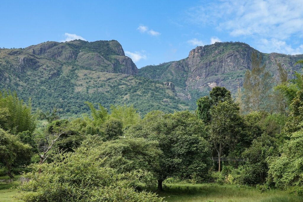
The Nilgiri Hills are the great meeting point of the Western Ghats and the Eastern Ghats in southern India and one of the most ecologically distinctive landscapes on the subcontinent. Rising abruptly from the plains of Tamil Nadu, Kerala, and Karnataka to plateau elevations of 2,000 metres and above, the Nilgiri Hills form a roughly triangular massif that anchors the Nilgiri Biosphere Reserve, the first to be declared in India. The name “Nilgiri” means “blue mountains”, a reference to the bluish haze that hangs over the slopes and the periodic blue flowering of the Kurinji shrub (Strobilanthes kunthianus). The Nilgiri Hills host Doddabetta, the third-highest peak in peninsular India south of the Himalayas, the UNESCO-listed Nilgiri Mountain Railway, the unique shola-grassland mosaic, several endemic species, and the homelands of distinctive tribal communities including the Toda, the Kota, the Kurumba, and the Irula.
| Nilgiri Hills | At a glance |
|---|---|
| Location | Junction of the Western Ghats and Eastern Ghats; Tamil Nadu, Kerala, Karnataka |
| Meaning of name | “Blue Mountains” (from the haze and the Kurinji bloom) |
| Highest peak | Doddabetta, 2,637 m (3rd-highest in peninsular India) |
| Rock & type | Archaean charnockite–gneiss; a block mountain (horst), not a fold mountain |
| Signature ecosystem | Shola–grassland mosaic |
| Biosphere reserve | Nilgiri Biosphere Reserve (1986) — India’s first |
| Heritage railway | Nilgiri Mountain Railway (UNESCO, 2005) |
| Indigenous communities | Toda, Kota, Kurumba, Irula |
Geographical Position and Extent
The Nilgiri Hills lie at the junction of three states: Tamil Nadu (which contains the bulk of the high plateau and the district of the same name), Kerala (the Wayanad portion and the western slopes), and Karnataka (the northern slopes and the Bandipur-Nagarahole region). The hills cover an area of approximately 2,500 square kilometres of high plateau and an additional 5,000 square kilometres of foothills.
The Nilgiri massif is sharply defined on all sides. The Palghat Gap (or Palakkad Gap) separates it from the Anaimalai Hills to the south. The Moyar valley separates it from the Mysore Plateau to the north. The Mukurthi cliffs fall away to the Coimbatore plain in the east. To the west, the slopes descend steeply to the Wayanad plateau and the Malabar Coast.
Where the Western and Eastern Ghats Meet
The Nilgiri Hills are the only place in peninsular India where the Western Ghats and the Eastern Ghats physically converge. The Western Ghats approach from the south as the Anaimalai–Palni system. The Eastern Ghats arrive from the north-east as the Biligirirangan and Talamalai hills. They merge in the Nilgiri massif, after which the Western Ghats continue south as a near-continuous wall to Kanyakumari.
Geology and Formation
The Nilgiri Hills are made up of ancient Archaean rocks, primarily charnockite, gneiss, and granulite, more than 2.6 billion years old. The Nilgiri block is part of the southern granulite terrain of peninsular India and was uplifted during Cenozoic block-faulting along the Moyar–Bhavani shear zone in the north and the Palghat Gap in the south. The Nilgiri Hills are therefore not a fold mountain but a block mountain or horst, uplifted along bounding faults.
The plateau surface is gently undulating at elevations between 1,800 and 2,400 metres. Above this plateau rise a series of rounded summits, the highest of which is Doddabetta (2,637 m), located about 9 kilometres east of Udhagamandalam (Ooty). Doddabetta is the third-highest peak in peninsular India after Anamudi (2,695 m) in the Anaimalai Hills and Meesapulimala (2,640 m). Other major peaks include Mukurthi (2,554 m), Hecuba (2,375 m), Kolaribetta (2,629 m), and Snowdon (2,532 m).
Climate
The Nilgiri Hills experience a sub-tropical highland climate. Mean annual temperature on the plateau ranges between 10 and 20 degrees Celsius, and frost occurs on winter nights. The hills receive heavy rainfall from both the south-west monsoon (June to September) and the north-east monsoon (October to December). Annual precipitation varies from 1,500 millimetres on the leeward eastern slopes to over 5,000 millimetres on the windward western slopes near the Wayanad. This sharp east-west precipitation gradient is one of the key drivers of the distinctive vegetation pattern.
The Shola-Grassland Mosaic
The most ecologically distinctive feature of the Nilgiri Hills is the shola-grassland mosaic. Sholas are stunted, dense, evergreen forests confined to sheltered folds, valleys, and depressions on the high plateau. Around the sholas stretch open, frost-tolerant grasslands dominated by Chrysopogon, Themeda, and Andropogon species. The two systems coexist in a stable ecological mosaic that has persisted for at least 30,000 years.
Sholas are characterised by an extremely high density of small-leaved evergreen trees (Syzygium, Rhododendron arboreum, Schefflera, Michelia nilagirica), a dense moss carpet, and high water retention. The grasslands above are subject to frost, wind, and periodic fire, and harbour ground-nesting birds, the Nilgiri tahr, and the endemic shola sky-island flora.
The shola-grassland mosaic has been severely fragmented by tea, coffee, eucalyptus, wattle, and pine plantations introduced during the colonial period. Wattle and eucalyptus have invaded the grasslands and changed their hydrology. Restoration of native grasslands and sholas is a major ongoing conservation programme.
Endemic Species
The Nilgiri Hills harbour a remarkable level of endemism. Notable endemics include the Nilgiri tahr (Nilgiritragus hylocrius), the state animal of Tamil Nadu and the only mountain ungulate in southern India; the Nilgiri langur; the Nilgiri marten; the Nilgiri laughingthrush; the Nilgiri flycatcher; and the Mukurthi-restricted Nilgiri pipit. The Kurinji flower, which carpets the slopes in a blue mass once every twelve years, gave the hills their name.
The Toda People
The Toda are the most studied tribal community of the Nilgiri Hills and one of the most distinctive small populations in India. They are a pastoral community whose entire traditional economy revolves around a unique semi-wild dwarf buffalo herd. The Toda live in barrel-vaulted huts called mund, organised into about 70 villages on the upper plateau. The Toda population is small (around 1,500 today) but their cultural footprint is enormous: their embroidery (poothkuli), their dairy temples, their funerary rites, and their kinship structure have been documented since the 19th century.
The other major tribal communities of the Nilgiri Hills are the Kota (artisans and musicians), the Kurumba (forest-dwellers and beekeepers), the Irula (associated with herbal medicine and snake-catching), and the Paniya and Kattunaikan in the Wayanad. Together these communities form a layered, mutually interdependent traditional economy that anthropologists have called the “Nilgiri tribal complex”.
Nilgiri Mountain Railway
The Nilgiri Mountain Railway (NMR) is a metre-gauge rack railway that climbs from Mettupalayam (326 m) on the Coimbatore plain to Udhagamandalam (2,203 m) at the heart of the Nilgiri Hills. Construction began in 1891 and was completed in 1908. The line uses the Abt rack-and-pinion system on the steepest grades, the only working rack railway in India. The NMR was inscribed by UNESCO in 2005 as an extension of the Mountain Railways of India World Heritage site. The 46-kilometre journey takes about five hours, passing through 16 tunnels and 250 bridges.
Nilgiri Biosphere Reserve
The Nilgiri Biosphere Reserve was declared in 1986 and was the first biosphere reserve in India. It covers 5,520 square kilometres across the three states of Tamil Nadu, Kerala, and Karnataka. The reserve includes the Mukurthi National Park, the Mudumalai Tiger Reserve, the Bandipur Tiger Reserve, the Nagarahole Tiger Reserve (Karnataka), the Wayanad Wildlife Sanctuary (Kerala), and the Silent Valley National Park to the south. The Nilgiri Biosphere Reserve is part of UNESCO’s World Network of Biosphere Reserves since 2012.
The reserve protects one of the largest contiguous populations of Asian elephants in the world (estimated 6,000 individuals), the highest tiger density in India outside the central forests, and major populations of the gaur, dhole, and sloth bear.
Mukurthi National Park
Mukurthi National Park, in the south-west corner of the Nilgiri plateau, is the core area for the Nilgiri tahr and the largest contiguous stretch of unmodified shola-grassland in the country. It covers 78 square kilometres at elevations between 2,000 and 2,600 metres.
Conservation Challenges
The Nilgiri Hills face severe and overlapping conservation pressures. Invasive species such as wattle (Acacia mearnsii), eucalyptus, pine, and the South American lantana have replaced large stretches of native shola and grassland. The expansion of tea, coffee, and vegetable cultivation has fragmented forest corridors. Human-wildlife conflict, particularly with elephants and gaur, has intensified as agricultural land has pushed into the buffer zones of the biosphere reserve. The Mukurthi National Park has been the focus of a long-running native-species restoration programme that includes the systematic removal of wattle and the re-seeding of native grassland. The Toda and other tribal communities have been recognised as key partners in conservation through participatory management of the grasslands and sholas they have used and shaped for centuries.
Hill Stations and Tourism
The main hill station of the Nilgiri Hills is Udhagamandalam (Ooty), founded as a colonial sanatorium in the 1820s. Coonoor and Kotagiri are smaller hill stations on the same plateau. The Nilgiri Hills are also known for tea cultivation (around 60,000 hectares), Nilgiri coffee, eucalyptus oil, and the cultivation of carrots, potatoes, and other temperate vegetables.
Frequently Asked Questions
Where are the Nilgiri Hills located?
The Nilgiri Hills are located at the meeting point of the Western Ghats and the Eastern Ghats in southern India, spread across the states of Tamil Nadu (most of the high plateau), Kerala (Wayanad), and Karnataka (northern slopes).
What is the highest peak in the Nilgiri Hills?
Doddabetta, at 2,637 metres, is the highest peak in the Nilgiri Hills and the third-highest peak in peninsular India after Anamudi and Meesapulimala in the Anaimalai Hills.
Why is the Nilgiri Mountain Railway a UNESCO heritage site?
The Nilgiri Mountain Railway was inscribed by UNESCO in 2005 because it is the only working rack-and-pinion railway in India and one of the most engineering-intensive metre-gauge mountain railways in the world. It uses the Abt system to climb from 326 metres to 2,203 metres over 46 kilometres.
What is the shola-grassland ecosystem?
The shola-grassland mosaic of the Nilgiri Hills is a stable mosaic of stunted evergreen montane forest (sholas) in valleys and folds, surrounded by frost-tolerant grasslands on the open plateau. It is one of the most distinctive ecosystems in peninsular India and is home to several endemic species.
Who are the Toda people of the Nilgiri Hills?
The Toda are a small pastoral tribal community of the Nilgiri Hills whose traditional economy is built around a unique dwarf buffalo herd. They live in barrel-vaulted huts called mund and are known for their poothkuli embroidery, dairy temples, and distinct funerary practices.
What animals are unique to the Nilgiri Hills?
Endemic animals of the Nilgiri Hills include the Nilgiri tahr (Tamil Nadu’s state animal), the Nilgiri langur, the Nilgiri marten, the Nilgiri laughingthrush, the Nilgiri flycatcher, and the Nilgiri pipit. The hills also host one of the largest populations of Asian elephants in the world.
Why was the Nilgiri Biosphere Reserve significant?
The Nilgiri Biosphere Reserve, declared in 1986, was the first biosphere reserve in India. It covers 5,520 square kilometres across three states and protects connected tiger reserves, national parks, and wildlife sanctuaries that together hold significant populations of elephants, tigers, gaur, and dhole.
How are the Nilgiri Hills different from the [Satpura Range](/satpura-mountain-range/)?
The Nilgiri Hills are an Archaean charnockite-gneiss block uplifted at the junction of the Western and Eastern Ghats. The Satpura Range is a much younger block-mountain system of central India formed largely on Gondwana sediments. The Nilgiri Hills are also much wetter and harbour the distinctive shola-grassland mosaic.
Tell Google you want more of this.
Add Anantam IAS as a preferred sourceOne tap, and this site shows up more often in your own Top Stories, AI Overviews and AI Mode. Remove it any time.





