Tampara Lake: Odisha’s Ramsar Wetland Explained (UPSC Environment)
Tampara Lake in Odisha's Ganjam district is a 300-hectare freshwater wetland, a Ramsar Site of International Importance and one of the lakes that carried India's tally toward 100. Here is the full picture — its biodiversity, the Ramsar Convention, Odisha's six Ramsar sites, the threats it faces and how it is being conserved — explained for UPSC GS3.
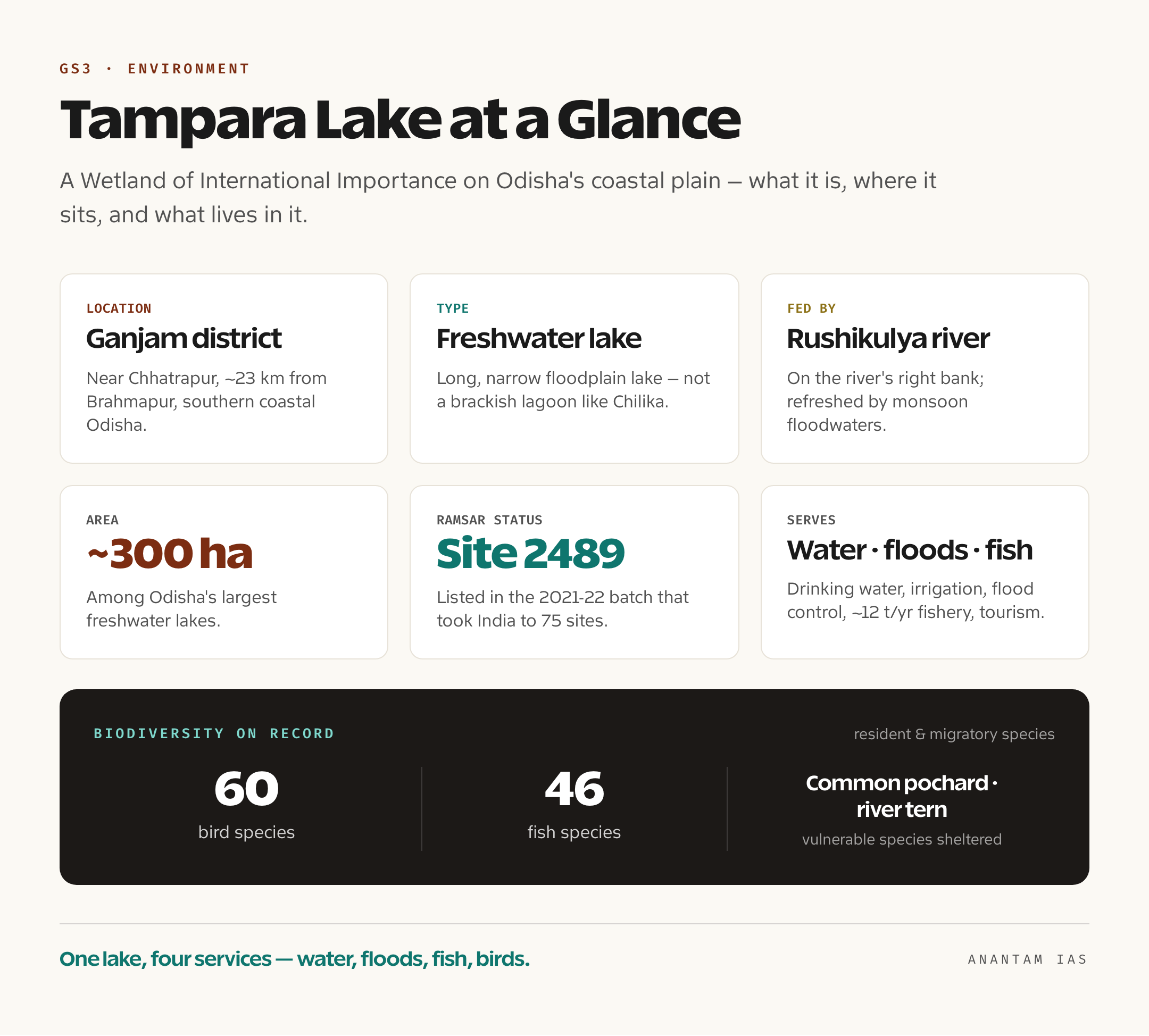
On the coastal plain of southern Odisha, a few kilometres inland from the Bay of Bengal, sits a wide sheet of clear water that most of India has never heard of. Locals call it the “glass water” of Ganjam, and for good reason — Tampara Lake is one of the few large freshwater lakes left in a state better known for its brackish lagoon at Chilika. It spreads across roughly 300 hectares near Chhatrapur, the headquarters of Ganjam district, on the right bank of the Rushikulya river. And in the batch of wetlands that carried India’s Ramsar tally to 75 in the seventy-fifth year of Independence, Tampara was one of the names announced — turning a quiet district lake into a Wetland of International Importance, the highest conservation label a wetland can carry.
That promotion matters more than it might seem, because Tampara is a textbook case of why India suddenly cares so much about its wetlands. It feeds drinking water to a town, irrigates farms, cushions floods when the monsoon swells the Rushikulya, yields about a dozen tonnes of fish a year, and shelters scores of resident and migratory birds — all at once. For a UPSC aspirant, it is the kind of specific, name-able example that lifts an answer on wetlands, the Ramsar Convention or biodiversity out of the generic. So this piece walks through what Tampara is, what the Ramsar label means, where Odisha and India stand in the global wetland count, what threatens these waters, and how they are being protected.
What Tampara Lake Is and How It Was Formed
Start with the lake itself, because the geography explains everything that follows. Tampara is a freshwater lake — not a brackish lagoon like Chilika up the coast — lying on Odisha’s narrow coastal plain in Ganjam district, about 23 kilometres from the city of Brahmapur (Berhampur) and close to the small town of Chhatrapur. It sits on the right bank of the Rushikulya, a rain-fed river that rises in the Eastern Ghats and drains into the Bay of Bengal, and the lake is fed and refreshed by floodwaters that spill from the river in the monsoon. That seasonal recharge is what keeps the water fresh and the biodiversity rich, and it is why the lake’s health is tied so tightly to the river’s.
The shape of the lake is the giveaway to how it formed. Tampara is long and narrow — a classic profile for a wetland that began as an old river channel or a low-lying depression that filled and stayed filled. Geographers describe such water bodies as relict or floodplain lakes: stretches of the coastal lowland where water collected and never fully drained, kept alive by the river beside them. In plain terms, it is the kind of natural reservoir the land makes on its own when a sluggish river, a flat plain and a high water table meet. None of this is exotic, but it is exactly the kind of formation that makes a lake both ecologically valuable and dangerously easy to lose, because shallow, flat-bottomed lakes silt up, shrink and choke faster than deep ones.
What turns this geography into something worth protecting is the work the lake quietly does. Tampara supplies drinking water to Chhatrapur town and water for farms and homes around it. It acts as a natural flood cushion in the monsoon, holding back water that would otherwise rush down the Rushikulya into settlements. It carries a modest local economy on its surface — fishing yields an estimated twelve tonnes of fish a year, supporting families along its banks, and the lake doubles as a recreation and water-sports spot, with boating facilities and even an Indian Army water-activities training centre on its waters. A single wetland delivering water security, flood control, livelihoods and tourism is the living definition of “ecosystem services,” and it is the reason a 300-hectare lake in a small district ended up on a global list.
The Life in the Water: Birds, Fish and Biodiversity
A wetland earns the Ramsar label on the strength of what lives in it, and Tampara holds its own. The lake supports about 60 species of birds and 46 species of fish — a dense roster for a water body this size. Some of those species are exactly the kind that conservation lists watch closely. The wetland shelters the common pochard, a diving duck classed as vulnerable on the global Red List; the river tern, another vulnerable bird that nests on sandbanks and hunts the shallows; and, among its fish, the common carp. The mix of resident waterbirds and winter migrants is what gives the lake its seasonal pulse, as flocks arrive on the East Asian-Australasian flyway — the great north-south migration corridor that brings birds down from Central and North Asia to winter on India’s wetlands.
The reason a lake like this packs in so much life comes down to what wetlands are. A wetland is land that is saturated or covered by water — shallow, sunlit and stuffed with nutrients — which makes it one of the most biologically productive ecosystems on Earth, rivalling rainforests and coral reefs. The shallow margins grow reeds and aquatic plants that feed fish and frame nesting cover for birds; the open water feeds the fishery; the whole system filters pollutants, recharges groundwater and locks away carbon in its waterlogged soils. So when birds gather at Tampara in the thousands, they are really a signal that the underlying machinery — water, plants, fish, insects — is still running. The birds are the visible proof of an invisible ecological service.
That is also why birdlife is the early-warning system for a wetland’s decline. When a lake silts up, when its water turns murky and oxygen-starved, or when its banks are built over, the migratory flocks thin out first and the resident species follow. A healthy count of pochards and terns at Tampara is, in effect, a clean bill of ecological health; a falling count would be the first symptom that something upstream has gone wrong. For an aspirant, this is the connective idea worth carrying into any wetland answer — biodiversity is not decoration on top of a wetland, it is the readout of whether the wetland is alive.
The Ramsar Convention and India’s Growing Tally
To understand why Tampara’s status is a big deal, you have to know what stands behind the word “Ramsar.” The Ramsar Convention is an international treaty for the conservation and “wise use” of wetlands, signed on 2 February 1971 in the Iranian city of Ramsar on the Caspian Sea — which is why the world now marks 2 February as World Wetlands Day. It is the oldest of the modern global environmental treaties and the only one devoted to a single ecosystem. Its central idea, “wise use,” is deliberately practical: it does not ask countries to fence wetlands off and ban all human activity, but to use them sustainably so that their ecological character survives alongside fishing, farming, tourism and water supply. When a country names a wetland a “Wetland of International Importance,” it commits to managing it on those terms.
The Convention also keeps a watch-list for wetlands in trouble, called the Montreux Record — a register of Ramsar sites where the ecological character has changed or is likely to change because of pollution, development or other human interference. It is essentially a “needs urgent attention” tag. India has two sites on it: Keoladeo National Park in Rajasthan and Loktak Lake in Manipur. Tampara is not on the Montreux Record, and the goal of conservation is to keep it that way — to keep it on the honour roll, not the watch-list. India joined the Convention in 1982 and designated Chilika Lake, also in Odisha, as its very first Ramsar site in 1981, so the country’s wetland story and Odisha’s are bound together from the start.
Since then India’s tally has climbed steeply, and the pace has been the headline. As of 5 June 2026, India has 100 Ramsar sites covering more than 1.36 million hectares — the largest network in Asia and among the largest in the world. The growth has been front-loaded into the last decade, with most of those sites added since 2014, including a celebrated rush in 2022 when eleven new wetlands lifted the count to 75 to mark the seventy-fifth year of Independence. Tampara was one of the names in that wave, alongside its Odisha neighbours Hirakud and Ansupa. (For the full, current roll, anantamias.com keeps an updated explainer of the total Ramsar sites in India.) The number to remember is clean — 100 sites by mid-2026 — and Tampara’s place in it tells the story of how fast India has moved.
Odisha’s Six Ramsar Sites and Why the State Matters
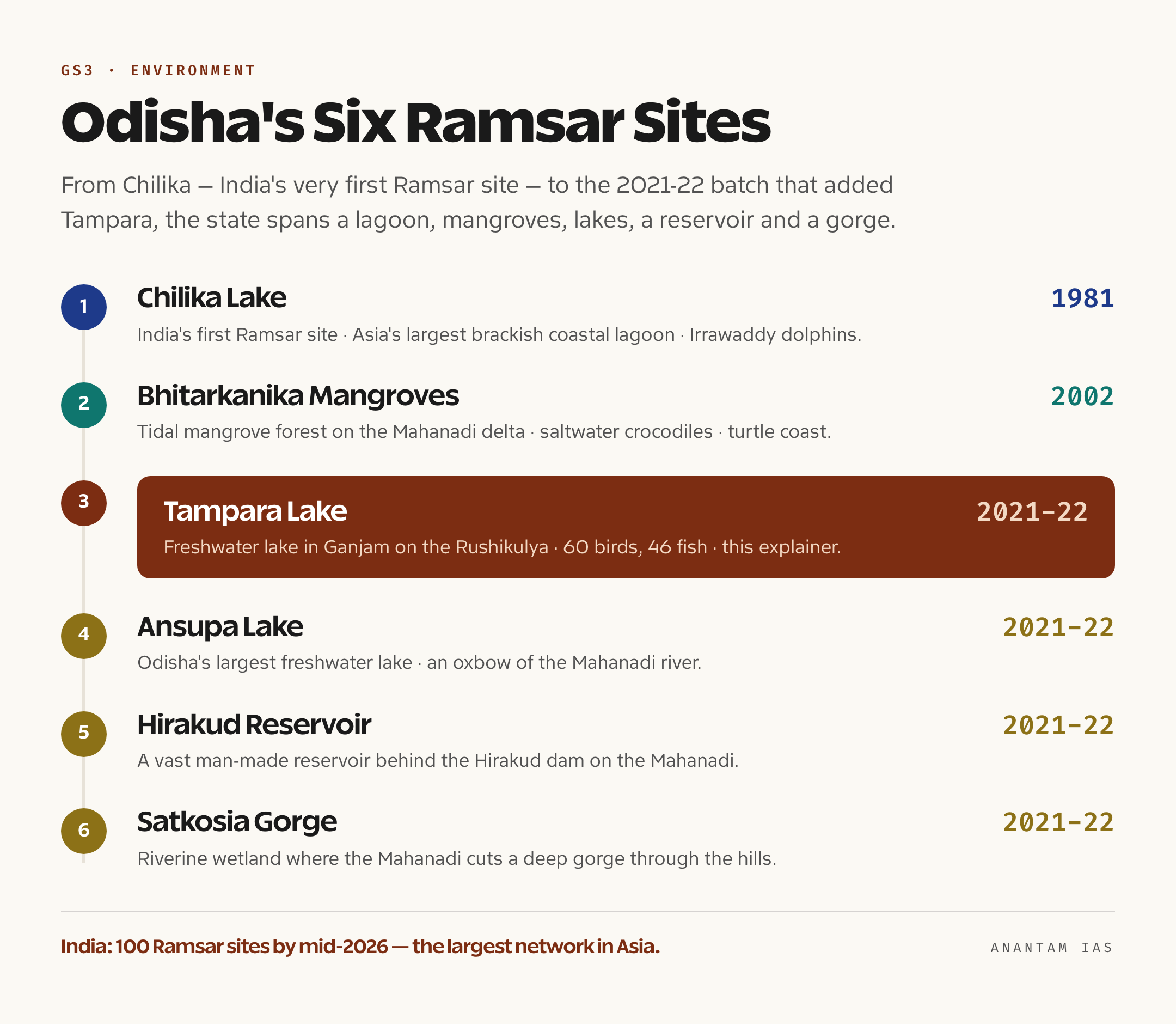
Odisha deserves a paragraph of its own, because it is one of India’s richest wetland states and the place where the country’s Ramsar journey began. The state has six Ramsar sites, and naming them is a quick way to earn marks. Chilika Lake, designated in 1981, is India’s first Ramsar site and Asia’s largest brackish-water coastal lagoon, famous for its Irrawaddy dolphins and vast congregations of migratory birds. Bhitarkanika Mangroves, added in 2002, is a tidal mangrove forest on the Mahanadi delta, home to saltwater crocodiles and a nursery for the Olive Ridley turtles that nest nearby. And then comes the 2021-22 batch — Tampara Lake, Ansupa Lake (the state’s largest freshwater lake, an oxbow of the Mahanadi), Hirakud Reservoir (the sprawling man-made reservoir behind the Hirakud dam) and Satkosia Gorge (where the Mahanadi cuts a deep gorge through the hills, a stretch of riverine wetland).
Set side by side, these six tell you something useful about how varied “wetlands” can be. Chilika is brackish and coastal; Bhitarkanika is a tidal mangrove; Tampara and Ansupa are natural freshwater lakes; Hirakud is a human-made reservoir; Satkosia is a river gorge. So the Ramsar definition stretches across lagoons, mangroves, lakes, reservoirs and rivers — a reminder that the Convention protects a whole family of water-rich ecosystems, not just postcard lakes. Tampara fits the natural-freshwater-lake slot, the same category as Ansupa, which makes the two a natural pair in any answer about Odisha’s wetlands.
Why does the state matter beyond its count? Because Odisha sits on the Bay of Bengal at the heart of the East Asian-Australasian flyway, so its lakes and lagoons are critical winter refuges for migratory birds travelling thousands of kilometres. Its wetlands also buffer a cyclone-prone coast, soaking up storm surges and floodwaters that would otherwise hit settlements harder — Bhitarkanika’s mangroves famously blunted the 1999 super-cyclone. So Odisha is not just collecting Ramsar tags; it is protecting a working line of defence for a vulnerable coast and a vital stopover for a continent’s birds. Tampara, small as it is, is one knot in that larger web.
Threats to the Wetland and How It Is Being Conserved
For all its value, a shallow coastal lake is a fragile thing, and Tampara faces the same pressures that grind down wetlands across India. The first is encroachment — farmland, construction and settlement creeping in on the margins, which shrinks the water spread and cuts off the natural channels that feed it. The second is eutrophication, the slow poisoning of the water by nutrient runoff: fertiliser and sewage flowing in from farms and the town feed an explosion of algae and weeds, which choke the surface, strangle oxygen out of the water and kill fish. The third is siltation, as soil washing off the catchment settles on the lake bed and makes an already shallow lake shallower. And the fourth is tourism and recreation pressure — boating, water sports and visitor crowds that, unmanaged, bring waste and disturbance to the very birdlife people come to see. Each pressure feeds the others, and together they are how a living wetland quietly turns into a dying one.
Against that, India has built a framework that the Ramsar designation plugs into. The backbone is the Wetlands (Conservation and Management) Rules, 2017, notified under the Environment (Protection) Act, 1986. These rules ban the most destructive activities in notified wetlands — converting them to non-wetland uses, permanent encroachment, dumping solid waste and discharging untreated effluent — and require each state to set up a State Wetlands Authority to identify, notify and manage its wetlands. The rules shifted the system toward a “wise use” approach run by the states, which is the same principle the Ramsar Convention asks for. So a Ramsar site like Tampara is meant to be managed by Odisha’s wetland authority under a site-specific plan, not just flagged on a global list and forgotten.
On top of the rules sits a push to make conservation pay for the people who live beside the water. The Union Budget for 2023-24 announced Amrit Dharohar, a scheme to be run over three years to promote the optimal, sustainable use of wetlands — boosting biodiversity, carbon storage, eco-tourism and, crucially, local incomes, so that communities have a stake in keeping the wetland alive. That is the key shift in India’s approach, and it is the line worth writing in an answer: conservation works best not by walling a wetland off from people, but by making a healthy wetland more valuable to them than a degraded one. For Tampara, with its fishing families, its drinking-water role and its tourism trade, that community-first model is not a slogan — it is the only realistic way the lake survives the next few decades.
For Your Mains Answer
This is a high-value topic for GS Paper 3, which covers environment, biodiversity, conservation and ecology. Questions on wetlands, the Ramsar Convention, India’s conservation record, ecosystem services and the threats of eutrophication and encroachment can all draw on this material, and Tampara is a ready-made case study. It can also surface as a Prelims fact (location, type, which state, which river) and as a clean example for the GS1 geography of lakes and drainage. The skill examiners reward is using a specific, correctly placed example to anchor a general argument — which is exactly what naming Tampara, Chilika and the Ramsar count lets you do.
How to Build the Answer
Move from the specific to the general and back. Open by placing Tampara — a 300-hectare freshwater lake in Ganjam, Odisha, on the Rushikulya, a Ramsar site. Use it to define what a wetland is and the ecosystem services it delivers (water, flood control, fishery, biodiversity, carbon). Bring in the Ramsar Convention (1971, “wise use,” Montreux Record) and India’s tally (100 sites by mid-2026, largest in Asia, Chilika the first). Then turn to threats (encroachment, eutrophication, siltation, tourism) and the response (Wetland Rules 2017, State Wetlands Authorities, Amrit Dharohar). Close with the balance the policy itself strikes — protection through wise use, not exclusion.
Common Mistakes to Avoid
Don’t call Tampara a lagoon — that’s Chilika; Tampara is a freshwater lake. Don’t say Chilika is a freshwater lake either — it is brackish. Don’t muddle the Ramsar count; use 100 sites as of mid-2026 and say it is the largest network in Asia. Don’t put Keoladeo or Loktak among the “healthy” sites — they are the two Indian wetlands on the Montreux Record, the watch-list. And don’t describe conservation as simply “banning human activity” — the whole thrust of “wise use” and Amrit Dharohar is sustainable use with local communities, and missing that misses the point.
A Compact Answer Spine
Tampara = 300-ha freshwater lake, Ganjam, Odisha, on the Rushikulya → Ramsar site in the 2022 batch that took India to 75 → wetlands = highly productive ecosystems delivering water, flood control, fishery, biodiversity, carbon → Ramsar Convention 1971, “wise use,” Montreux Record (Keoladeo, Loktak) → India now has 100 Ramsar sites (mid-2026), largest in Asia, Chilika the first (1981) → Odisha has six sites → threats: encroachment, eutrophication, siltation, tourism → response: Wetland Rules 2017 + State Wetlands Authorities + Amrit Dharohar → verdict: protect through wise use, with communities, not exclusion.
Diagram or Flowchart Idea
Sketch a simple wetland cross-section: river feeding the lake on one side, reed-fringed shallows with birds and fish, and arrows pointing out to the four services — drinking water, flood control, fishery and biodiversity. Beside it, a small ladder of Odisha’s six Ramsar sites with years. A clean two-part visual like this shows both what a wetland does and where Tampara sits, and it sketches fast under exam pressure.
A Balanced-Conclusion Line
A line that lands the marks: “Tampara Lake shows that India’s wetland strategy has matured from listing sites to living with them — protecting a 300-hectare lake not by sealing it off, but by making its clean water, its fish and its birds worth more to the people of Ganjam than a drained and built-over basin ever could be.”
How to Use Data Without Cramming
You need only a handful of anchors, not a dossier: about 300 hectares (the lake), 60 bird and 46 fish species (its biodiversity), 2 February 1971 (the Ramsar Convention), 100 Ramsar sites by mid-2026 (India’s tally), 1981 (Chilika, India’s first), and six (Odisha’s count). Attribute them plainly — “as the Ramsar listing records” or “under the Wetlands Rules of 2017” — rather than scattering numbers loose, and the answer reads as authoritative without looking crammed.
FAQ
Where is Tampara Lake and what kind of lake is it? Tampara Lake is in Ganjam district in southern coastal Odisha, near Chhatrapur and about 23 kilometres from Brahmapur, on the right bank of the Rushikulya river. It is a freshwater lake — not a brackish lagoon like Chilika — spread over roughly 300 hectares, and it is counted among Odisha’s largest freshwater lakes. It supplies drinking water, irrigates farms, cushions monsoon floods and supports a local fishery and tourism.
Why is Tampara Lake a Ramsar site, and when was it designated? Tampara was recognised as a Wetland of International Importance in the 2021-22 cycle, as one of the eleven wetlands whose addition took India’s Ramsar tally to 75 in the seventy-fifth year of Independence. It qualified on its biodiversity — about 60 bird species and 46 fish species, including the vulnerable common pochard and river tern — and on the ecosystem services it provides. The Ramsar label commits India to managing the lake through “wise use.”
How many Ramsar sites does India have now, and how many are in Odisha? As of 5 June 2026, India has 100 Ramsar sites covering more than 1.36 million hectares — the largest such network in Asia. Odisha has six of them: Chilika Lake (1981, India’s very first Ramsar site), Bhitarkanika Mangroves (2002), and Tampara Lake, Ansupa Lake, Hirakud Reservoir and Satkosia Gorge from the 2021-22 batch.
What threatens Tampara Lake and how is it being protected? The main threats are encroachment on its banks, eutrophication from farm and sewage runoff that triggers algae and weed growth, siltation that shrinks the shallow lake, and unmanaged tourism. It is protected under the Wetlands (Conservation and Management) Rules, 2017, which bar destructive activities and require a State Wetlands Authority to manage each wetland, backed by the Amrit Dharohar scheme announced in the 2023-24 Budget, which promotes sustainable, community-led use of wetlands.
Practice Questions
Prelims MCQs
- With reference to Tampara Lake, recently in the news, consider the following statements. Which is/are correct?
(a) It is a freshwater lake located in the Ganjam district of Odisha
(b) It is a brackish-water coastal lagoon on the Mahanadi delta
(c) It lies on the right bank of the Rushikulya river
(d) Both
(a) and (c)
Answer: (d) Tampara is a freshwater lake in Ganjam district, Odisha, on the right bank of the Rushikulya; the brackish coastal lagoon on the Odisha coast is Chilika, not Tampara. - The Ramsar Convention on Wetlands is associated with which of the following?
(a) A city in Iran where the treaty was signed in 1971
(b) A city in Switzerland where the convention secretariat sits
(c) The Indian Wetland Rules of 2017
(d) The United Nations Convention to Combat Desertification
Answer: (a) The Convention is named after Ramsar, a city in Iran on the Caspian Sea, where it was signed on 2 February 1971; that date is now World Wetlands Day. - The “Montreux Record” under the Ramsar Convention refers to which of the following?
(a) The list of all Wetlands of International Importance
(b) A register of Ramsar sites whose ecological character is threatened or changing
(c) The fund that finances wetland conservation worldwide
(d) The annual report on the world’s wetland area
Answer: (b) The Montreux Record is a watch-list of Ramsar sites under threat; India’s two listed sites are Keoladeo National Park (Rajasthan) and Loktak Lake (Manipur). - Match the following Odisha Ramsar sites with the year they were designated.
(a) Chilika Lake — 2021
(b) Bhitarkanika Mangroves — 1981
(c) Chilika Lake — 1981; Bhitarkanika Mangroves — 2002
(d) Tampara Lake — 2002
Answer: (c) Chilika was India’s first Ramsar site, designated in 1981; Bhitarkanika Mangroves followed in 2002; Tampara, Ansupa, Hirakud and Satkosia Gorge came in the 2021-22 batch. - Which of the following statements about wetlands and their conservation in India is correct?
(a) The Wetlands (Conservation and Management) Rules were notified in 2017 under the Environment (Protection) Act, 1986
(b) Amrit Dharohar is a scheme launched to mine peat from wetlands
(c) India has fewer Ramsar sites than any other Asian country
(d) Eutrophication improves the oxygen content of lake water
Answer: (a) The 2017 Rules sit under the Environment (Protection) Act, 1986; Amrit Dharohar (Budget 2023-24) promotes sustainable wetland use; India has the largest Ramsar network in Asia; and eutrophication depletes, not improves, dissolved oxygen.
Mains Practice Questions
- Wetlands have been called the “kidneys of the landscape.” In light of Tampara Lake’s designation as a Ramsar site, discuss the ecosystem services freshwater wetlands provide and the threats they face in India. (15 marks, 250 words)
- “India’s wetland conservation has shifted from listing sites to living with them.” Critically examine this statement with reference to the Wetlands (Conservation and Management) Rules, 2017 and the Amrit Dharohar scheme. (15 marks, 250 words)
- Explain the objectives and significance of the Ramsar Convention. How has India’s growing tally of Ramsar sites strengthened, and complicated, its wetland conservation effort? (15 marks, 250 words)
- Eutrophication, encroachment and siltation are the recurring killers of India’s shallow lakes. Using a wetland of your choice, analyse these threats and suggest a community-centred conservation strategy. (10 marks, 150 words)
- Odisha, with six Ramsar sites spanning a lagoon, mangroves, lakes, a reservoir and a river gorge, illustrates the diversity of India’s wetlands. Discuss the ecological and disaster-mitigation importance of such wetlands along India’s eastern coast. (15 marks, 250 words)