Beas River — Origin, Course, Dams, and Role in the Indus Water Treaty
Complete guide to the Beas River covering its origin at Rohtang, course through Himachal Pradesh and Punjab, Pong and Pandoh Dams, Beas-Sutlej Link, and UPSC relevance.
The Beas River (ancient name: Vipasha) is one of the five rivers that give Punjab (“land of five rivers”) its name. It is the shortest of the five major tributaries of the Indus River system but plays a vital role in the irrigation, hydroelectric power, and water-sharing framework of northern India. For UPSC aspirants, the Beas is important for Indian Geography, the Indus Water Treaty, and river interlinking projects.
Origin
The Beas originates at Beas Kund, a glacial lake situated at an altitude of approximately 4,062 metres near the Rohtang Pass in the Pir Panjal Range of the Himalayas. Beas Kund lies in the Kullu district of Himachal Pradesh.
The name "Beas" is derived from the ancient Sanskrit name Vipasha, mentioned in Vedic literature. According to legend, the sage Vashishtha tried to drown himself in the river by tying his limbs (vipash = freed from bonds), but the river freed him, hence the name Vipasha.
The Beas is also historically significant as the river where Alexander the Great's army refused to advance further eastward in 326 BCE, marking the eastern limit of his conquests. This event occurred at a point on the Beas called Hyphasis by the Greeks.
Course
The Beas flows for approximately 470 km before joining the Sutlej River. Its course can be divided into two distinct sections:
Upper Course (Himachal Pradesh)
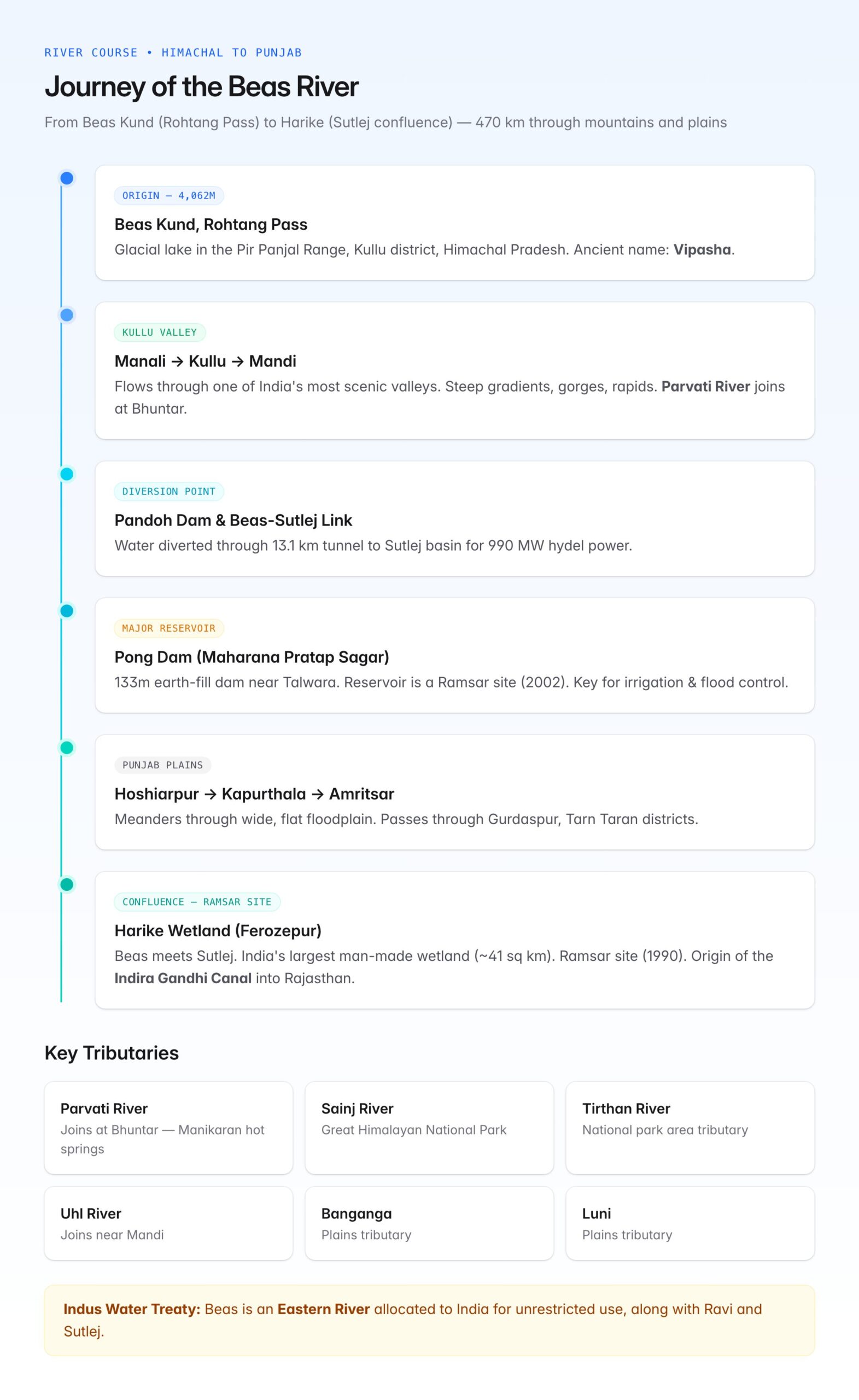
- From Beas Kund, the river flows southward through the Kullu Valley, one of India's most scenic valleys.
- It passes through or near the towns of Manali, Kullu, and Mandi in Himachal Pradesh.
- The valley section is characterised by steep gradients, gorges, and rapids — ideal for hydroelectric projects.
- Near Mandi, the river turns westward and enters a narrow gorge section.
- It passes through the Pandoh area and then flows towards Kangra and Hamirpur districts.
Lower Course (Punjab Plains)
- The Beas enters the Punjab plains near Talwara in the Hoshiarpur district.
- In the plains, it meanders through a wide, flat floodplain.
- It flows through or near the districts of Hoshiarpur, Gurdaspur, Amritsar, Kapurthala, and Tarn Taran.
- The river eventually joins the Sutlej River at a point called Harike (near Harike Pattan) in the Ferozepur district.
Key fact: The Beas does not directly join the Indus. It merges with the Sutlej, and the combined river flows westward into Pakistan to join the Chenab (forming the Panjnad), which then joins the Indus.
Major Dams and Projects
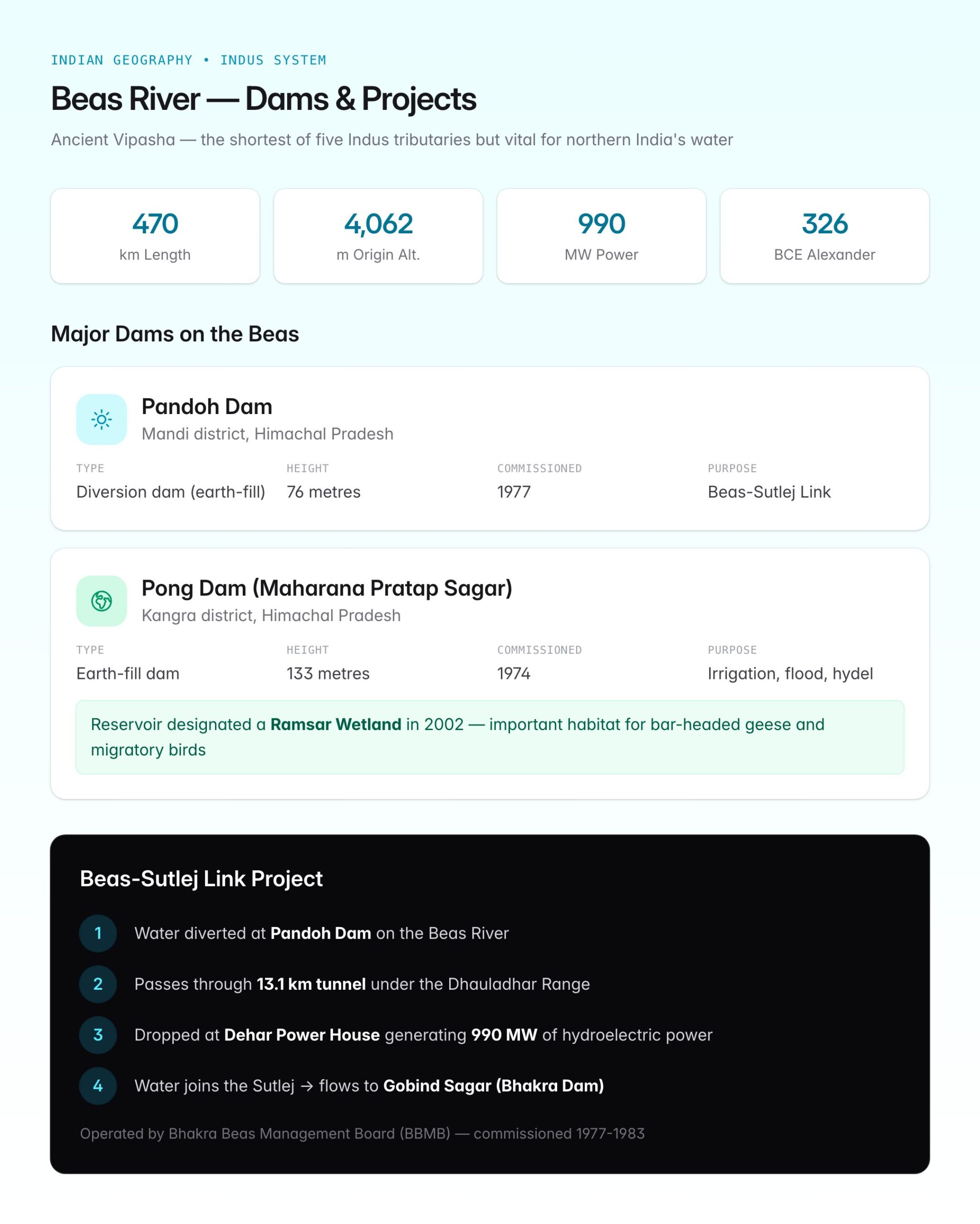
Pandoh Dam
| Feature | Detail |
|---|---|
| Location | Pandoh, Mandi district, Himachal Pradesh |
| River | Beas |
| Type | Diversion dam (earth-fill) |
| Purpose | Diverts Beas water through a tunnel to the Sutlej for the Beas-Sutlej Link Project |
| Commissioned | 1977 |
| Height | 76 metres |
Pong Dam (Maharana Pratap Sagar)
| Feature | Detail |
|---|---|
| Location | Pong, Kangra district, Himachal Pradesh (near Talwara) |
| River | Beas |
| Type | Earth-fill dam |
| Purpose | Irrigation, flood control, hydroelectric power |
| Commissioned | 1974 |
| Height | 133 metres |
| Reservoir | Maharana Pratap Sagar — one of India's largest man-made wetlands |
| Ramsar site | Designated a Ramsar Wetland in 2002 |
The Pong Dam reservoir is an important habitat for migratory birds, especially bar-headed geese, and attracts birdwatchers and ecologists.
Beas-Sutlej Link Project
The Beas-Sutlej Link Project is one of India's major river interlinking projects, designed to divert surplus Beas water to the Sutlej basin for hydroelectric power generation.
How It Works
- Water from the Beas is diverted at the Pandoh Dam through a 13.1 km tunnel under the Dhauladhar Range.
- The diverted water is dropped at the Dehar Power House (also known as Slapper Power House) on the Sutlej, generating 990 MW of hydroelectric power.
- The water then joins the Sutlej and flows downstream to the Gobind Sagar Reservoir (Bhakra Dam).
This project, commissioned in stages between 1977 and 1983, is operated by the Bhakra Beas Management Board (BBMB), a joint body representing the central government and the states of Punjab, Haryana, Rajasthan, and Himachal Pradesh.
Beas and the Indus Water Treaty
Under the Indus Water Treaty (1960) between India and Pakistan, the Beas is classified as an Eastern River, along with the Ravi and Sutlej. These three rivers were allocated to India for unrestricted use.
This allocation enabled India to build the Pong Dam, the Pandoh Dam, and the Beas-Sutlej Link Project. The water from these eastern rivers irrigates vast tracts of Punjab, Haryana, and Rajasthan (through the Indira Gandhi Canal and other canal systems).
| River Category | Rivers | Allocated To |
|---|---|---|
| Eastern Rivers | Ravi, Beas, Sutlej | India |
| Western Rivers | Indus, Jhelum, Chenab | Pakistan |
Harike Wetland (Confluence Point)
The point where the Beas meets the Sutlej at Harike in Ferozepur district, Punjab, is the site of the Harike Wetland (also called Harike Pattan). It is:
- India's largest man-made wetland (approximately 41 sq km)
- A Ramsar site (designated in 1990)
- The starting point of the Indira Gandhi Canal (formerly Rajasthan Canal), which carries Sutlej-Beas water deep into the Thar Desert in Rajasthan
- An important habitat for the Indus River dolphin (though critically endangered) and numerous migratory bird species
Cities and Towns Along the Beas
| City/Town | District | State |
|---|---|---|
| Manali | Kullu | Himachal Pradesh |
| Kullu | Kullu | Himachal Pradesh |
| Mandi | Mandi | Himachal Pradesh |
| Sujanpur Tira | Hamirpur | Himachal Pradesh |
| Talwara | Hoshiarpur | Punjab |
| Kapurthala | Kapurthala | Punjab |
Tributaries of the Beas
The Beas receives several smaller tributaries during its course:
- Parvati River (joins at Bhuntar, near Kullu) — known for the Manikaran hot springs
- Sainj River — flows through the Great Himalayan National Park
- Tirthan River — another tributary from the national park area
- Uhl River — joins near Mandi
- Banganga and Luni — smaller tributaries in the plains
The Parvati Valley through which the Parvati River flows is one of Himachal Pradesh's most popular trekking and tourism destinations.
Environmental Concerns
- Pollution: In the plains section, the Beas suffers from agricultural runoff, industrial effluents, and sewage discharge, particularly near urban areas in Punjab.
- Fish kills: A major pollution incident in 2015 led to the death of thousands of fish near Harike, drawing attention to water quality issues.
- Sand mining: Illegal sand mining along the riverbed has caused ecological damage and bank erosion.
- Reduced flow: Diversion of water through the Beas-Sutlej Link and irrigation canals has reduced the river's natural flow, affecting downstream ecology.
UPSC Relevance
GS Paper I: Indian Geography — Himalayan river systems, drainage of India. GS Paper III: Water resources, irrigation, river interlinking, environmental issues.
Key Prelims facts:
- The Beas originates at Beas Kund near Rohtang Pass at ~4,062 m altitude in Himachal Pradesh.
- Its ancient name is Vipasha; Alexander's army refused to advance beyond this river in 326 BCE.
- Total length is approximately 470 km.
- It joins the Sutlej at Harike in Ferozepur district, Punjab.
- Major dams: Pong Dam (Maharana Pratap Sagar, Ramsar site) and Pandoh Dam.
- The Beas-Sutlej Link Project diverts Beas water through a tunnel to the Sutlej for 990 MW hydroelectric power.
- Under the Indus Water Treaty, the Beas is an Eastern River allocated to India.
- Harike Wetland at the Beas-Sutlej confluence is a Ramsar site and the origin of the Indira Gandhi Canal.
- The project is managed by the Bhakra Beas Management Board (BBMB).