Cardamom Hills — Geography, Ecology and Significance in the Western Ghats
Cardamom Hills in southern Western Ghats: Kerala-Tamil Nadu, cardamom plantations, Nilgiri tahr, UNESCO biodiversity hotspot and wildlife.
The Cardamom Hills — known locally as the Yela Mala — are a range in the southern Western Ghats, straddling the border of Kerala and Tamil Nadu. Named after the cardamom (elaichi) plantations that carpet their slopes, the hills form a critical ecological link between the Anamalai range to the north and the Agastyamala–Ashambu hills to the south. They lie within the Western Ghats UNESCO World Heritage Site and are one of the eight global biodiversity hotspots named by Norman Myers. For UPSC candidates, the Cardamom Hills appear across Geography, Environment, and Agriculture papers.
Location and Extent
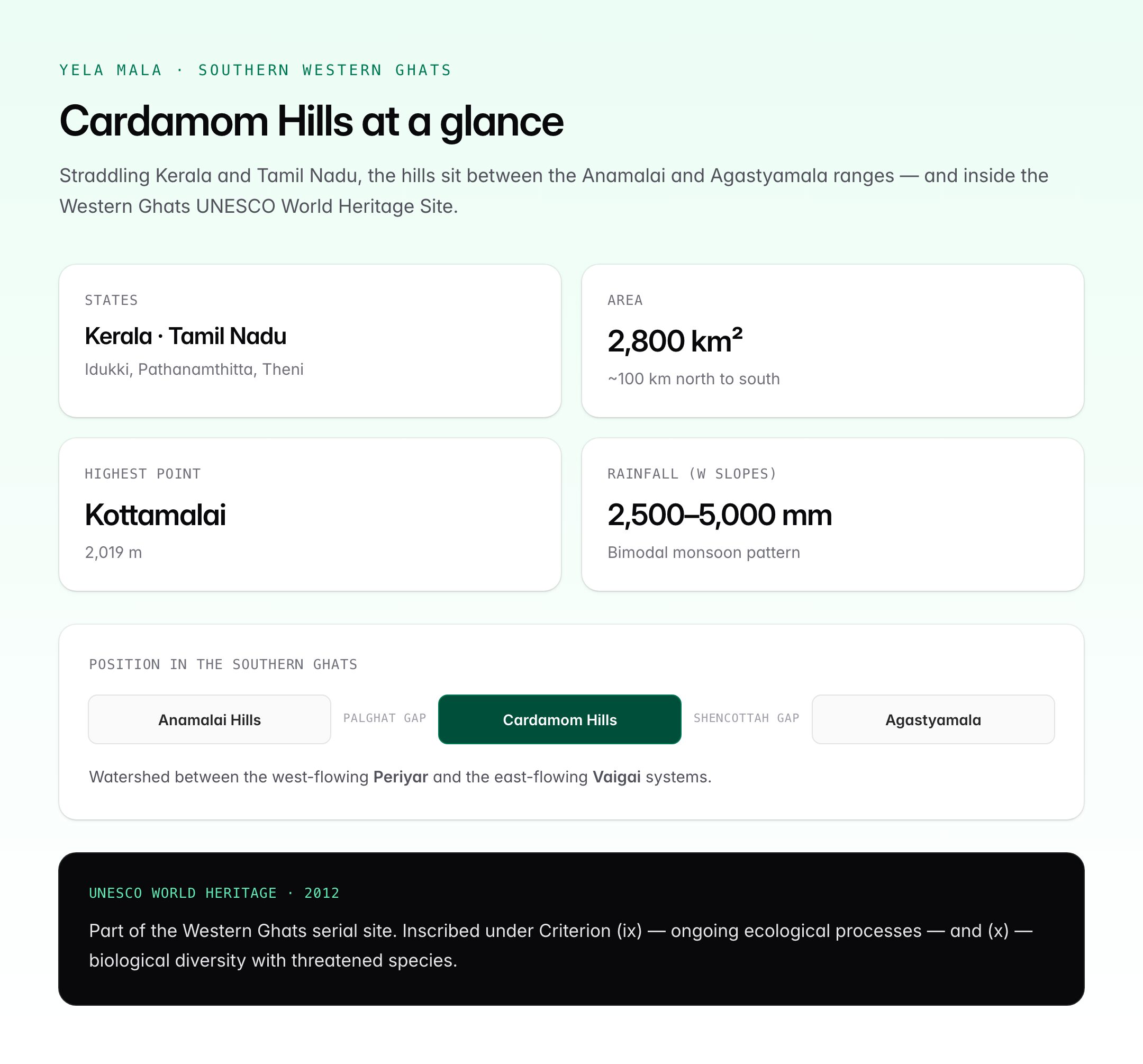
The Cardamom Hills sit in the extreme south of the Western Ghats, between roughly 9°00′N and 10°00′N and 76°45′E and 77°30′E.
| Parameter | Detail |
|---|---|
| States | Mainly Kerala (Idukki, Pathanamthitta); eastern fringe in Tamil Nadu (Theni) |
| Area | Approximately 2,800 sq km |
| Highest point | Kottamalai (2,019 m) |
| Mean elevation | 900–1,500 m |
| Length (roughly) | 100 km north-south |
| Adjacent ranges (N) | Anamalai Hills (separated by Palghat Gap, more north) |
| Adjacent ranges (S) | Varushanad and Agastyamala (separated by Shencottah Gap) |
The hills form the watershed between Periyar (west-flowing) and Vaigai (east-flowing) river systems.
Geological and Physical Setting
The Cardamom Hills are part of the ancient Precambrian rock system underlying the Western Ghats — mostly charnockite and khondalite granulitic gneisses. These are hard, dense, crystalline rocks over 2 billion years old.
- Slopes: steep on the western (Kerala) side, gentler on the eastern (Tamil Nadu) side — characteristic of the Western Ghats asymmetry
- Drainage: many short, rapid rivers on the west; longer, slower rivers on the east
- Soils: deep red and laterite on the plateau surfaces; rich forest humus in valleys
- Rainfall: 2,500 to 5,000 mm annually on western slopes; 1,000 to 1,500 mm in eastern rain-shadow
Climate and Hydrology
The hills lie squarely in the south-west monsoon path between June and September. The eastern slopes also receive the north-east (retreating) monsoon in October–November, making this one of the few regions of India with a bimodal rainfall pattern.
Major Rivers Rising in or Through the Hills
| River | Flow | Emptying into |
|---|---|---|
| Periyar | West | Vembanad Lake, Arabian Sea |
| Pamba | West | Vembanad Lake |
| Thamiraparani (partial headwater) | East | Gulf of Mannar |
| Vaigai (tributaries rise here) | East | Palk Strait |
The Periyar Lake — an artificial reservoir behind the Mullaperiyar Dam (1895) — lies at the heart of the hills and is central to the Periyar Tiger Reserve.
Protected Areas in and Around the Cardamom Hills
The Cardamom Hills host some of India's most important protected areas.
| Protected Area | State | Notable for |
|---|---|---|
| Periyar Tiger Reserve | Kerala | Elephants, tigers, boat-safari tourism |
| Periyar National Park | Kerala | Core zone inside the tiger reserve |
| Eravikulam National Park (northern edge, Anamalai) | Kerala | Nilgiri tahr — largest population |
| Chinnar Wildlife Sanctuary | Kerala | Rain-shadow wildlife, grizzled giant squirrel |
| Pambadum Shola NP | Kerala | Highest shola forests |
| Mathikettan Shola NP | Kerala | Shola-grassland mosaic |
| Kurinjimala Sanctuary | Kerala | Neelakurinji flowering (every 12 years) |
| Megamalai WLS | Tamil Nadu | Western Ghats evergreen forests |
| Srivilliputhur Grizzled Squirrel WLS | Tamil Nadu | Grizzled giant squirrel |
The Srivilliputhur-Megamalai Tiger Reserve was declared in 2021, adding a major protected landscape on the eastern slopes.
Vegetation and Flora
The Cardamom Hills are among the wettest and most forested parts of peninsular India. Vegetation changes sharply with elevation.
| Altitude | Forest type |
|---|---|
| 500–800 m | Moist deciduous forest |
| 800–1,400 m | Tropical evergreen and semi-evergreen |
| 1,400–1,800 m | Montane wet evergreen (shola) in folds; grassland on ridges |
| Above 1,800 m | Shola-grassland mosaic |
Shola forests are stunted, moss-draped evergreen patches in hollows, interspersed with rolling montane grasslands — a biome unique to the southern Western Ghats.
The hills are the natural home of wild cardamom (Elettaria cardamomum), from which the cultivated spice plant was domesticated. Other commercially important plants:
- Pepper (Piper nigrum) — native understorey vine
- Coffee (robusta and arabica)
- Tea — planted on higher slopes, especially around Munnar
- Sandalwood in drier fringes
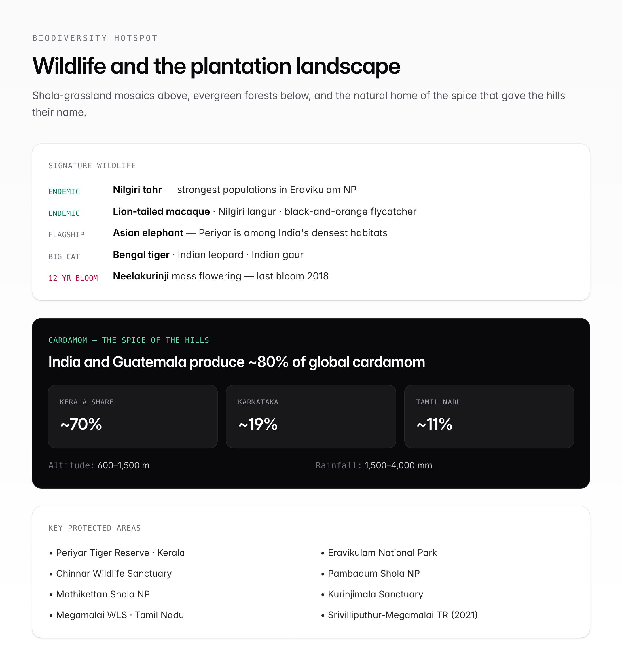
- Neelakurinji (Strobilanthes kunthiana) — mass-flowers every 12 years, last bloom 2018
Wildlife
The hills are a critical corridor for large mammals.
Mammals
- Nilgiri tahr (Nilgiritragus hylocrius) — endemic; strongest populations in Eravikulam
- Asian elephant — Periyar is among India's densest elephant habitats
- Bengal tiger
- Indian leopard
- Indian gaur (Indian bison)
- Lion-tailed macaque — endemic to the Western Ghats
- Nilgiri langur — endemic
- Sambar, barking deer, mouse deer
- Sloth bear in drier zones
Birds and Reptiles
- Malabar grey hornbill, Nilgiri pipit, white-bellied shortwing
- Black-and-orange flycatcher — endemic
- King cobra, Malabar pit viper, Travancore tortoise
Cardamom Plantations — The Agricultural Story
The hills lend their name to the spice because cardamom thrives exactly in the ecological conditions they provide: altitude 600–1,500 m, rainfall 1,500–4,000 mm, shaded understorey of evergreen trees, and slightly acidic loamy soil.
| Parameter | Detail |
|---|---|
| Main growing areas | Idukki (Kerala), Theni and Dindigul (TN), parts of Coorg (Karnataka) |
| Global share | India and Guatemala together produce ~80% of global cardamom |
| Share of Indian production | Kerala ~70%, Karnataka ~19%, Tamil Nadu ~11% |
| Regulator | Spices Board of India (under Ministry of Commerce) |
| Indian Cardamom Research Institute | Myladumpara, Idukki — founded 1978 |
India's "Alleppey Green" small cardamom is among the most prized varieties globally. The Cardamom Hill Reserve (CHR) — a protected forest–plantation landscape — covers around 1,02,000 hectares in Idukki district.
The Anamalai–Cardamom–Agastyamala Connection
The hills are the central segment of the Agasthyamalai Biosphere Reserve corridor that runs almost continuously from the Nilgiris to Kanyakumari.
| Landscape segment | North-to-south |
|---|---|
| Nilgiri Hills | Nilgiri Biosphere Reserve |
| Palghat Gap | Break (~40 km wide) |
| Anamalai Hills | Anamalai Tiger Reserve |
| Cardamom Hills | Periyar Tiger Reserve, Eravikulam NP |
| Shencottah Gap | Break |
| Agastyamala / Ashambu Hills | Agastyamala Biosphere Reserve, Kalakkad-Mundanthurai TR |
The Palghat Gap and Shencottah Gap are narrow low-altitude breaks in the Ghats that act as biogeographical filters — species distributions north and south of each gap differ measurably.
UNESCO World Heritage Status
The Western Ghats was inscribed as a UNESCO World Heritage Site in 2012. Of the 39 serial components, 19 are in Kerala and Tamil Nadu within or adjacent to the Cardamom Hills. The site was recognised under:
- Criterion (ix) — outstanding example of ongoing ecological and biological processes
- Criterion (x) — biological diversity including threatened species
The Cardamom Hills thus carry both national protection (Wildlife Protection Act, 1972; Forest Conservation Act, 1980) and international protection (UNESCO).
Threats and Conservation Concerns
Despite legal safeguards, the hills face serious pressures.
- Encroachment for plantations and settlement (especially cardamom, tea, coffee)
- Monoculture expansion reducing natural forest connectivity
- Habitat fragmentation by roads (Kumily–Theni, Munnar–Bodimettu)
- Climate change — erratic monsoons, temperature rise of ~0.5°C over two decades in upper elevations
- Neelakurinji habitat loss to eucalyptus and wattle plantations
- Landslides — worsening with slope destabilisation (Kerala 2018 floods, Wayanad 2024)
- Hydro-power dams submerging valley forests
- Human–wildlife conflict — elephants raiding crops; tiger–livestock conflict
Gadgil Committee (2011) and Kasturirangan Committee (2013) reports on Western Ghats ecological protection directly concern the Cardamom Hills zone, and their partial implementation remains a live policy debate.
UPSC Relevance
The Cardamom Hills intersect several UPSC subjects.
- Prelims: Location between Kerala and Tamil Nadu, southern Western Ghats, Periyar Tiger Reserve, Eravikulam NP, Palghat Gap vs Shencottah Gap, Nilgiri tahr (endemic), Neelakurinji flowering cycle, Mullaperiyar Dam water dispute
- Mains GS Paper I (Geography): Physiography of Western Ghats, peninsular drainage, rainfall patterns, rain-shadow effect
- Mains GS Paper III (Environment): Biodiversity hotspots, Western Ghats UNESCO site, Gadgil and Kasturirangan Committee recommendations, ESA (Ecologically Sensitive Area) debates
- Mains GS Paper III (Agriculture): Cardamom cultivation, Spices Board, plantation economy of Idukki
- Current affairs: Wayanad landslides, Srivilliputhur-Megamalai Tiger Reserve (2021), Mullaperiyar safety disputes, Kerala–TN water politics
Candidates should be able to distinguish between the Anamalai, Cardamom, and Agastyamala hills (all in the southern Western Ghats), note the Palghat Gap as a biogeographical boundary, and know that the hills lend their name to the cardamom spice because this is the plant's natural ecological niche.