
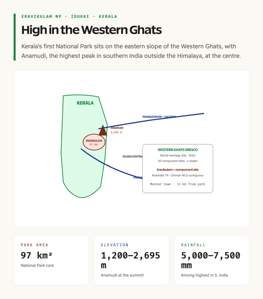
Eravikulam National Park is the first national park established in Kerala and one of the most ecologically significant high-altitude protected areas in southern India. It sits in Idukki district, on the eastern slope of the Western Ghats, at altitudes between 1,200 and 2,695 metres. The 97 square kilometre core holds the highest peak in southern India outside the Himalaya, Anamudi at 2,695 metres, the largest surviving population of the endangered Nilgiri Tahr, the rare and famous 12-year bloom of Neelakurinji, and one of the best preserved patches of the Shola-grassland ecosystem on the planet. For UPSC GS-III, the park is a high-frequency topic that connects species conservation, the Western Ghats biodiversity hotspot, and the UNESCO World Heritage framework in a single landscape.
The park’s policy weight comes from a single-species story. The Nilgiri Tahr, Nilgiritragus hylocrius, was reduced to a few hundred animals by the 1960s through hunting and habitat loss, and Eravikulam was the last stronghold. The 1975 Wildlife Sanctuary notification and the 1978 upgrade to National Park were the first dedicated protected-area actions in Kerala and were driven explicitly by the need to save the Tahr. The recovery since then is one of the cleanest single-species conservation success stories in India.
Quick Facts on Eravikulam National Park
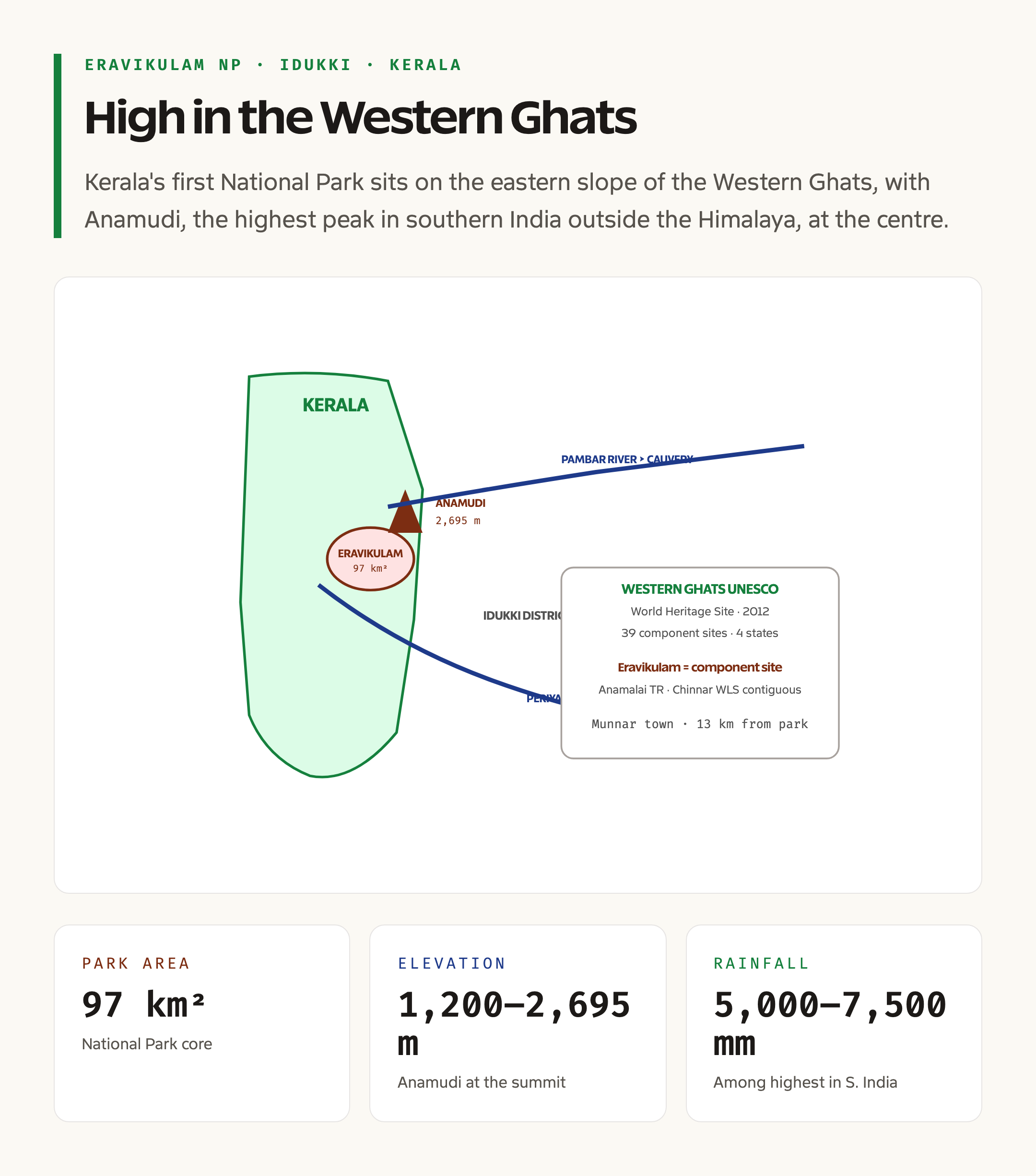
Eravikulam lies at 10.2 degrees North, 77.05 degrees East, in Devikulam taluk of Idukki district, Kerala. The park covers 97 square kilometres of high-altitude rolling grassland and Shola forest at elevations between 1,200 and 2,695 metres. The terrain is plateau and ridge, sloping down to the Pambar and Periyar river valleys, with the Anamudi massif at the centre. The park is part of the larger Anamalai-Eravikulam landscape and is included in the Western Ghats UNESCO World Heritage Site, inscribed in 2012 as a serial property covering 39 component sites across four states.
The area was first declared a Wildlife Sanctuary in 1975, and was upgraded to a National Park in 1978. The total Tahr population at Eravikulam is around 750 animals, the largest single-site count for the species. Other key species include the gaur, the sloth bear, the leopard, the Nilgiri marten, the Nilgiri langur, the Nilgiri pipit, and the great Indian hornbill. The park is the type locality for several Western Ghats endemic plant species and is the most studied site for the 12-year mass-flowering of Strobilanthes kunthiana, the famed Neelakurinji.
What Eravikulam Is
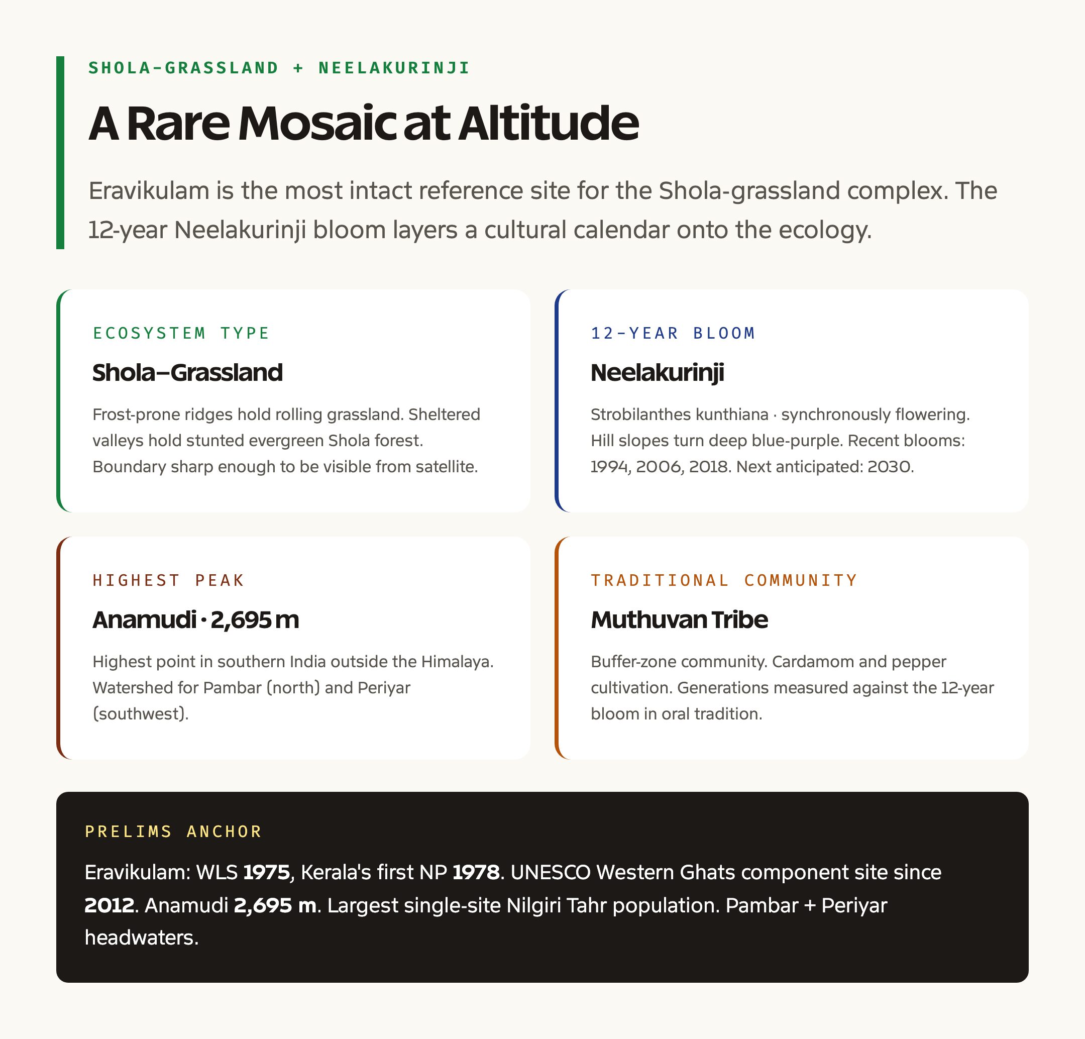
Eravikulam is a high-altitude rolling-grassland landscape interspersed with patches of Shola forest in the valleys. The Shola-grassland complex is unique to the higher reaches of the Western Ghats and the Nilgiri-Anamalai ranges. Grasslands occupy the windswept ridges and plateaus, while the moisture-loving Shola trees survive only in sheltered valleys and folds where frost is less intense and water is reliable. The two ecosystems are not random alternatives. They form a fine-grained mosaic shaped by frost incidence, soil depth, fire regime, and elevation, and the boundary is sharp enough to be visible in satellite imagery.
The park’s centrepiece is the Anamudi massif, which at 2,695 metres is the highest point in India south of the Himalaya. The massif acts as a watershed for several rivers that drain into both the eastern and western slopes of the Ghats. The Pambar River drains the northern slope, while the Periyar River and its tributaries drain the southwestern slope. The Eravikulam plateau itself is the source of several small streams that feed into both river systems.
Background and Historical Context
The high-altitude grasslands of the Western Ghats have been shaped by human use for centuries. The Muthuvan tribal community, the principal traditional inhabitants of the Eravikulam area, practiced shifting cultivation and seasonal grazing on the plateaus. From the 1870s, the area passed under tea-plantation companies, particularly the Kanan Devan Hills Produce Company, which leased the high-altitude tracts and developed the Munnar tea estates that today surround the park.
The Nilgiri Tahr was a hunted animal through the colonial period. By the 1960s, the species had been pushed to a few isolated populations across the Western Ghats, with the largest remaining group at Eravikulam. The 1975 sanctuary notification and the 1978 National Park upgrade were the first dedicated conservation actions in Kerala and were driven explicitly by the need to save the Tahr. The Kanan Devan company surrendered land for the park in a model of corporate-government collaboration that has since been studied in conservation literature. The 2012 UNESCO inscription of the Western Ghats as a World Heritage Site brought the park into the global heritage framework. For broader context, read the parent guides on national parks of India and biodiversity in India.
Key Provisions of Eravikulam Conservation
The park is managed under the four-tier framework that governs every Indian national park. The first tier is the National Park itself, the 97 square kilometre core where no human activity other than research, monitoring, and tightly controlled tourism is permitted. The second tier is the buffer zone, which includes the surrounding tea estates and revenue land where land-use is regulated through the eco-sensitive zone notification under the Environment Protection Act 1986. The third tier is the larger Anamalai-Eravikulam landscape, which includes Anamalai Tiger Reserve in Tamil Nadu and Chinnar Wildlife Sanctuary, and forms a contiguous block of high-altitude protected area across the inter-state boundary.
Statutory authority sits with the Kerala State Forest Department and the Wildlife Warden of Eravikulam, who reports to the Chief Wildlife Warden of Kerala. The park is also a notified component site of the Western Ghats UNESCO World Heritage property, which adds an international monitoring layer. The Wildlife Protection Act 1972 underpins all enforcement, and Schedule I status protects the Nilgiri Tahr against hunting and trade.
Why Eravikulam Matters
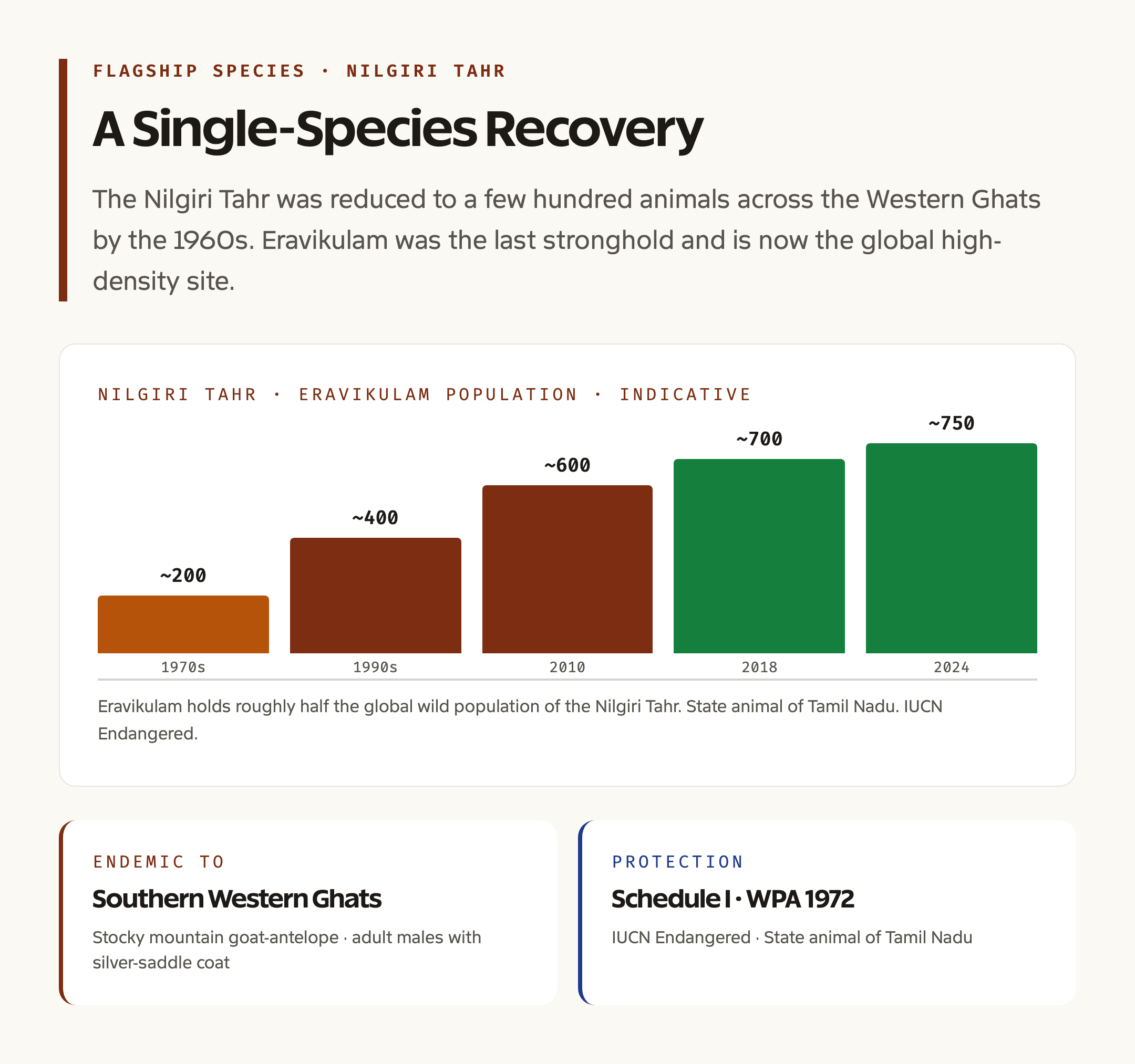
Eravikulam matters first as the global stronghold for the Nilgiri Tahr. The species is the state animal of Tamil Nadu, is endemic to the southern Western Ghats, and is classified as Endangered on the IUCN Red List. The park hosts roughly half the total wild population of the species, and the recovery from a few hundred animals in the 1970s to the present count of around 750 at Eravikulam alone is the cleanest single-species success in southern India.
It matters second as a reference site for the Shola-grassland ecosystem. The high-altitude grasslands of the Western Ghats have been heavily converted to tea, eucalyptus, and wattle plantations, especially in the Nilgiris. The Eravikulam plateau is one of the few patches where the original mosaic of grassland and Shola is intact at landscape scale, and long-term ecological monitoring there has produced the baseline data for restoration efforts in other ranges.
It matters third for the Neelakurinji phenomenon. Strobilanthes kunthiana is a synchronously flowering plant whose seeds germinate, grow, and bloom together over a 12-year cycle. When the bloom happens, the hill slopes turn purple at landscape scale. The Eravikulam plateau is the most reliable site to witness the bloom, and the event draws domestic and international tourism that funds significant parts of the protected-area budget. The most recent mass blooms occurred in 1994, 2006, and 2018, and the next is anticipated in 2030.
Detailed Analysis: Geography and Ecosystem
The park sits on the eastern slope of the Western Ghats, on the high tableland that separates the Cardamom Hills from the Anamalai range. Average elevation is between 1,800 and 2,400 metres on the plateau, rising to 2,695 metres at the summit of Anamudi. The terrain is a series of rolling hills, frost hollows, and steep slopes, with extensive cliff faces on the western and northern edges. Soils are shallow, peaty, and acidic, derived from charnockite and granitic gneiss bedrock.
The climate is a high-altitude tropical regime with cold, dry winters and a wet summer monsoon. Annual rainfall is between 5,000 and 7,500 millimetres, among the highest in southern India. Frost occurs on most clear winter nights at higher elevations, and this frost regime is the principal control on the Shola-grassland boundary. Temperatures range from a winter minimum near zero to a summer maximum of around 22 degrees, much cooler than the surrounding lowlands.
The vegetation is a fine-grained mosaic of grassland and Shola. The grasslands are dominated by Chrysopogon zeylanicus, Eulalia phaeothrix, Cymbopogon, and Themeda species, with a rich understory of herbs and dwarf shrubs. The Shola patches are dominated by Bischofia, Litsea, Syzygium, Microtropis, and Rhododendron arboreum at the upper edge. The endemic plant list runs to several hundred species, including the famous Strobilanthes kunthiana.
Flora and Fauna
The flagship species is the Nilgiri Tahr, a stocky mountain goat-antelope endemic to the southern Western Ghats. Adult males have a thick, dark brown coat with a silver saddle and curved horns up to 40 centimetres long. Females are smaller and lighter coloured. The species lives in herds of up to 100 animals on the open grassland and uses the Shola patches for shade and shelter.
Other mammals include the gaur, the sloth bear, the leopard, the rare and elusive Nilgiri marten, the Nilgiri langur, the lion-tailed macaque in lower elevations, the dusky striped squirrel, and the small Indian civet. Bird life is rich and includes several Western Ghats endemics, the Nilgiri pipit, the white-bellied shortwing, the Nilgiri flycatcher, the Nilgiri laughingthrush, the broad-tailed grassbird, and the Nilgiri wood pigeon. The great Indian hornbill is recorded in the lower-elevation Shola patches. The amphibian and invertebrate diversity is exceptional, with a high proportion of micro-endemics that are found nowhere else.
The Pambar and Periyar Hydrology
The park is the source of streams that flow into both the Pambar and Periyar river systems. The Pambar drains the northeastern slope and joins the Amaravathi, eventually feeding the Cauvery basin in Tamil Nadu. The Periyar drains the southwestern slope and is the longest river in Kerala, eventually emptying into the Vembanad estuary on the Arabian Sea. The hydrology of the Eravikulam plateau therefore connects two of the major river systems of southern India and ensures that any change in the high-altitude vegetation, fire regime, or land use has downstream consequences in two states. For the parent guide, see river systems of India.
The plateau itself holds several glacial-style cirques and shallow tarns, particularly on the Anamudi massif, that are reminders of the Pleistocene cold periods. The Lakkom and Rajamala waterfalls are among the most photographed landscape features of the park and are the most accessible visitor destinations. The Rajamala area is also the principal location for Tahr viewing and is where the Forest Department conducts regular census work.
Tribes, Culture, and Surrounding Communities
The Muthuvan tribe is the principal traditional community in and around Eravikulam. Muthuvan settlements are concentrated on the lower slopes and in the buffer zone, with traditional livelihood based on swidden agriculture, the cultivation of cardamom and pepper, and seasonal collection of forest produce. The community has a long association with the high-altitude landscape and was historically familiar with the Tahr’s behaviour, which informed early conservation work.
The 12-year Neelakurinji bloom is woven into Muthuvan oral tradition. The community measured generations against the bloom cycle, with elders recalling 6 to 7 blooms in a lifetime as a marker of long life. The 2018 bloom drew several hundred thousand visitors to the Munnar area and produced both a tourism windfall and a serious management challenge for the park, which had to balance public access with the protection of the flowering plants and the Tahr habitat.
Connections With Related UPSC Topics
The park connects with several recurring UPSC themes. It connects with biodiversity in India as a key node in the Western Ghats hotspot. It connects with national parks of India and is the first national park in Kerala. It connects with Kaziranga National Park as a parallel single-flagship landscape in a different biome. It connects with the State of India Environment 2026 report where the latest data on Western Ghats biodiversity and Nilgiri Tahr numbers are tabulated. And it connects with environmental laws in India through the Wildlife Protection Act, the Environment Protection Act, and the eco-sensitive zone notification framework.
For prelims, anchor four facts. First, Eravikulam was Kerala’s first National Park, declared in 1978 after a 1975 Wildlife Sanctuary notification. Second, it lies in Idukki district and includes Anamudi at 2,695 metres, the highest peak in southern India outside the Himalaya. Third, the park hosts the largest single-site population of the endangered Nilgiri Tahr. Fourth, the park is part of the Western Ghats UNESCO World Heritage Site, inscribed in 2012, and contains the most reliable site for the 12-year Neelakurinji bloom.
Frequently Asked Questions
Where is Eravikulam National Park located?
Eravikulam National Park is in Devikulam taluk of Idukki district, Kerala, on the eastern slope of the Western Ghats. The park covers 97 square kilometres at elevations between 1,200 and 2,695 metres and includes the Anamudi peak, the highest point in southern India outside the Himalaya. The nearest town is Munnar, around 13 kilometres away.
Why is Eravikulam famous?
Eravikulam is famous for three reasons. It is the largest single-site population of the endangered Nilgiri Tahr. It hosts the rare 12-year mass blooming of Neelakurinji, Strobilanthes kunthiana, that turns the hills purple. And it contains Anamudi, the highest peak in southern India outside the Himalaya. The park is also part of the Western Ghats UNESCO World Heritage Site.
When was Eravikulam declared a National Park?
The area was first declared a Wildlife Sanctuary in 1975 and was upgraded to a National Park in 1978. It is the first national park in Kerala. The 1978 notification was driven by the need to give the Nilgiri Tahr higher legal protection in the wake of severe population decline through the 1960s.
What is the Shola-grassland ecosystem?
The Shola-grassland ecosystem is a fine-grained mosaic of high-altitude rolling grassland and pockets of stunted evergreen forest in valleys and folds. The grasslands occupy frost-prone ridges and plateaus, while the moisture-loving Shola trees survive only in sheltered valleys. The mosaic is unique to the higher elevations of the Western Ghats and the Nilgiri-Anamalai ranges and is a centre of plant endemism.
What is Neelakurinji and when does it bloom?
Neelakurinji, Strobilanthes kunthiana, is a flowering plant of the high-altitude grasslands of the Western Ghats that blooms once every 12 years. When the bloom happens, the hill slopes turn a deep blue-purple at landscape scale. The Eravikulam plateau is the most reliable site to witness the bloom. The most recent mass blooms occurred in 1994, 2006, and 2018, and the next is anticipated in 2030.
Which tribes live around Eravikulam?
The principal traditional community in and around Eravikulam is the Muthuvan tribe. Muthuvan settlements are concentrated on the lower slopes and in the buffer zone. Traditional livelihood is based on swidden agriculture, the cultivation of cardamom and pepper, and the seasonal collection of forest produce. The community has a long association with the high-altitude landscape and was historically familiar with Nilgiri Tahr behaviour.
Tell Google you want more of this.
Add Anantam IAS as a preferred sourceOne tap, and this site shows up more often in your own Top Stories, AI Overviews and AI Mode. Remove it any time.





