Daily Digest
UPSC · Civil Services Examination
Current Affairs · Wednesday, 14 January 2026
Current affairs curated and edited by Anantam IAS faculty — pulled from The Hindu, PIB, IDSA, Foreign Affairs and the ministries. Read, annotate, revise.
Old Rajinder Nagar · Delhi 110005 · anantamias.com
Shaksgam Valley: The Geography and Strategic Stakes of the Trans-Karakoram Tract
Why in News?
The Shaksgam Valley — the high, glaciated Trans-Karakoram Tract wedged between Pakistan-occupied Kashmir and China’s Xinjiang — is back in strategic focus after fresh reports of Chinese road and construction activity in and around the area, close to the Siachen sector.
India holds that the roughly 5,180 sq km tract is its own sovereign territory, illegally handed over by Pakistan to China under the 1963 Sino-Pakistan boundary agreement, since it lies within the erstwhile princely state of Jammu and Kashmir that acceded to India in 1947.
- What it is: the Shaksgam Valley or Trans-Karakoram Tract, a high-altitude expanse north of the Karakoram watershed.
- Area: about 5,180 sq km of largely uninhabited glaciers, ridges and the Shaksgam (Shimshal) river basin.
- The cession: Pakistan transferred administration of the tract to China under the 1963 Sino-Pakistan boundary agreement.
- India’s stand: New Delhi treats the agreement as illegal and void, since Pakistan had no sovereign title to cede Indian territory.
- Strategic proximity: it abuts the Siachen Glacier, the Karakoram Pass and the contested Aksai Chin theatre to the east.
- Latest trigger: open-source imagery has flagged Chinese infrastructure and access roads creeping into the tract, raising fresh concern in India.
The development matters in the context of:
- Three-way frontier: the tract sits where Indian-claimed territory, Pakistani control and Chinese administration converge in the western Himalaya.
- PoK linkage: it adjoins Gilgit-Baltistan, the area of Pakistan-occupied Kashmir through which the China-Pakistan Economic Corridor also runs.
- Siachen overhang: any Chinese consolidation near the tract increases pressure on India’s positions on the Saltoro Ridge and Siachen.
- Cartographic stakes: India’s official maps continue to show the tract as part of the Union Territory of Ladakh, not as Chinese territory.
UPSC Relevance
Prelims Relevance
- Shaksgam Valley location — north of the Karakoram main divide, between PoK / Gilgit-Baltistan and Xinjiang.
- Trans-Karakoram Tract as the formal name; area roughly 5,180 sq km.
- The 1963 Sino-Pakistan boundary agreement and the territory it transferred to China.
- Distinction between the Karakoram and the Himalaya as separate mountain systems.
- The Karakoram Pass — historic trade route linking Ladakh with Central Asia (Yarkand).
- Siachen Glacier and the Saltoro Ridge in relation to the tract.
- Aksai Chin — the China-administered plateau India claims, lying east of the tract.
- Difference between the Line of Control (LoC), the Line of Actual Control (LAC) and an international boundary.
- Gilgit-Baltistan as part of Pakistan-occupied Kashmir; the Instrument of Accession, 1947.
- The K2 massif and major glaciers (Siachen, Baltoro) of the Karakoram zone.
Mains Relevance
GS Paper 1 (Geography)
- Describe the physiography of the Trans-Karakoram region — relief, glaciation and drainage — and explain why such terrain shapes strategic behaviour.
- Locate the Shaksgam Valley with respect to the Karakoram divide, the Siachen sector and the Karakoram Pass, and bring out its watershed significance.
GS Paper 2 (International Relations)
- Examine India’s legal position that the 1963 Sino-Pakistan boundary agreement is void, and its implications for the India-Pakistan-China boundary tangle.
- Assess how Chinese activity in PoK and the Trans-Karakoram Tract intersects with the China-Pakistan strategic partnership and India’s security.
Essay
- Use the tract as a concrete anchor in essays on contested borders, sovereignty and the geography of power.
- Relevant to essays on how physical terrain conditions the strategic choices of states.
Background and Context
Where the Shaksgam Valley sits
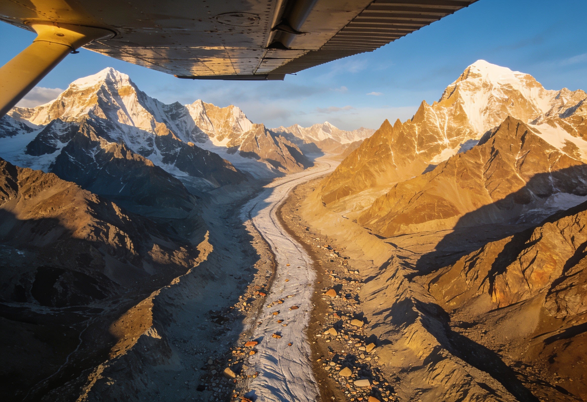
A high, glaciated bowl on the far side of the Karakoram watershed, far from any settled population.
- Setting: the valley lies north of the main Karakoram divide, draining toward the Shaksgam (Shimshal) river that flows into the Yarkand system in Xinjiang.
- Extent: the Trans-Karakoram Tract covers roughly 5,180 sq km of ridges, snowfields and glaciers, almost entirely uninhabited.
- Neighbours: it adjoins Gilgit-Baltistan (in PoK) to the west and China’s Xinjiang to the north and east.
- Mountain context: the Karakoram range here is distinct from the Himalaya proper, hosting some of the world’s highest peaks and longest mid-latitude glaciers.
The 1963 cession and how it happened
The tract changed hands not by conquest but by an agreement India never recognised.
- The deal: under the 1963 Sino-Pakistan boundary agreement, Pakistan transferred administration of the Shaksgam tract to China.
- Provisional clause: the text itself called the settlement provisional, to be renegotiated once the Kashmir dispute was resolved between India and Pakistan.
- Why India objects: New Delhi holds that Pakistan, as an illegal occupier of part of Jammu and Kashmir, had no sovereign title to cede the area.
- Outcome: China gained a contiguous high-altitude frontier with PoK, tightening the China-Pakistan strategic embrace along India’s north-western flank.
Why the legal status matters
The dispute turns on the chain of title that runs back to 1947.
- Accession, 1947: the princely state of Jammu and Kashmir acceded to India through the Instrument of Accession, bringing its entire territory — including Gilgit-Baltistan and the Shaksgam area — under Indian claim.
- Indian position: the whole of the erstwhile state, including Pakistan-occupied Kashmir, is integral to India, so the 1963 transfer is void.
- Parliamentary resolution: India’s Parliament has resolved that PoK and areas ceded to China remain Indian territory awaiting recovery.
- Cartography: official Indian maps continue to depict the tract within the Union Territory of Ladakh.
The strategic neighbourhood: Siachen, Karakoram Pass, Aksai Chin
The tract is hemmed in by some of the most militarised and contested geography on Earth.
- Siachen: the tract lies just north of the Siachen Glacier and the Saltoro Ridge, where Indian and Pakistani troops face off at extreme altitude.
- Karakoram Pass: a historic gateway between Ladakh and Central Asia (Yarkand), it is one of the great high mountain passes of the region.
- Aksai Chin: to the east lies the China-administered plateau India claims, scene of the 1962 conflict and a continuing flashpoint.
- Convergence: control of the tract gives China interior lines linking Xinjiang, Aksai Chin and PoK, with the China-Pakistan Economic Corridor running nearby.
LoC versus LAC versus international boundary
The terminology is exam-critical and explains why the tract is so legally tangled.
- Line of Control (LoC): the military ceasefire line between India and Pakistan in Jammu and Kashmir, formalised after the 1972 Simla Agreement; it is not an international border.
- Line of Actual Control (LAC): the notional line separating Indian-controlled areas from Chinese-controlled areas, including near Aksai Chin; it is undemarcated and disputed.
- International boundary: a settled, mutually recognised border — which neither the India-Pakistan nor the India-China alignment fully is in this sector.
- Shaksgam’s status: India claims it; China administers it; Pakistan handed it over — so it sits at the intersection of all three categories.
What renewed Chinese activity signals
Construction in remote terrain is rarely just about logistics; it changes facts on the ground.
- Roads and access: reported road-building and infrastructure in and around the tract improve Chinese reach toward the Siachen-Karakoram zone.
- Dual-use risk: high-altitude roads, tracks and camps in such terrain typically carry dual civilian-military value.
- Pressure on Siachen: better Chinese mobility north of Siachen can stretch India’s already demanding logistics on the Saltoro Ridge.
- India’s response: New Delhi has repeatedly protested Chinese activity in PoK and the tract as a violation of its sovereignty and territorial integrity.
Way Forward
Hold the legal and diplomatic line
- Consistent protest: keep formally objecting to any third-party activity in PoK and the Trans-Karakoram Tract as illegal occupation of Indian territory.
- Cartographic clarity: continue depicting the tract within Ladakh on official maps and in international forums.
Strengthen situational awareness
- Surveillance: sustain satellite and aerial monitoring of construction near Siachen, the Karakoram Pass and the tract.
- Logistics: deepen all-weather connectivity and high-altitude readiness on the Indian side of the Saltoro-Siachen sector.
Manage the China-Pakistan axis
- Diplomacy: factor the tract into the wider India-China boundary dialogue and India’s engagement on border management.
- Coalition: highlight the legal infirmity of activity in disputed PoK in relevant bilateral and multilateral conversations.
Conclusion
A small tract, an outsized stake: the Shaksgam Valley is empty of people but full of strategic meaning, sitting where Indian claims, Pakistani control and Chinese administration meet in the high Karakoram.
The legal thread is unbroken: India’s case rests on the 1947 accession of Jammu and Kashmir, which makes the 1963 Sino-Pakistan agreement a transfer of territory Pakistan never lawfully held.
Geography is destiny here: with Siachen, the Karakoram Pass and Aksai Chin all in the neighbourhood, every road built in this terrain reshapes the strategic map of India’s northern frontier.
UPSC Practice Questions
Prelims MCQ 1
With reference to the Shaksgam Valley (Trans-Karakoram Tract), consider the following statements:
- It lies north of the main Karakoram watershed, adjoining Gilgit-Baltistan and Xinjiang.
- It was transferred by Pakistan to China under the 1963 Sino-Pakistan boundary agreement.
- India regards the 1963 transfer as legal and final.
How many of the above statements are correct?
(a) Only one (b) Only two (c) All three (d) None
Answer: (b) Only two
Explanation:
Statements 1 and 2 are correct: the tract lies north of the Karakoram divide and was ceded by Pakistan to China in 1963. Statement 3 is wrong — India treats the transfer as illegal and void, since Pakistan had no sovereign title to the area.
Prelims MCQ 2
Which one of the following correctly distinguishes the Line of Control (LoC) from the Line of Actual Control (LAC)?
(a) The LoC separates India and China, while the LAC separates India and Pakistan (b) The LoC is the India-Pakistan ceasefire line in J&K, while the LAC is the disputed India-China separation line (c) Both are fully demarcated international boundaries recognised by all parties (d) The LoC lies in Aksai Chin, while the LAC lies along the Karakoram Pass
Answer: (b) The LoC is the India-Pakistan ceasefire line in J&K, while the LAC is the disputed India-China separation line
Explanation:
The LoC is the India-Pakistan military ceasefire line in Jammu and Kashmir, formalised after the 1972 Simla Agreement. The LAC is the undemarcated, disputed line separating Indian and Chinese controlled areas, including near Aksai Chin. Neither is a settled international boundary.
UPSC Mains Questions
- Locate the Shaksgam Valley with respect to the Karakoram watershed, the Siachen sector and Aksai Chin, and explain why its physiography makes it strategically significant despite being largely uninhabited.
- India regards the 1963 Sino-Pakistan boundary agreement as illegal and void. Examine the legal basis of this position and its implications for the India-Pakistan-China boundary disputes.
- Distinguish between the Line of Control, the Line of Actual Control and an international boundary. How does the status of the Trans-Karakoram Tract illustrate the difficulty of border settlement in this region?
Sources: Ministry of External Affairs, Government of India and Survey of India, Department of Science and Technology.
Frequently Asked Questions
What is the Shaksgam Valley?
The Shaksgam Valley, or Trans-Karakoram Tract, is a high, glaciated expanse of about 5,180 sq km lying north of the main Karakoram divide, between Pakistan-occupied Gilgit-Baltistan and China’s Xinjiang. It is largely uninhabited terrain of ridges, snowfields and the Shaksgam river basin.
How did China come to control it?
Pakistan transferred administration of the tract to China under the 1963 Sino-Pakistan boundary agreement. The agreement itself described the arrangement as provisional, to be revisited once the Kashmir dispute was settled — but China has administered the area ever since.
Why does India call the cession illegal?
Because the tract lies in the erstwhile princely state of Jammu and Kashmir, which acceded to India in 1947. India holds that Pakistan, as an illegal occupier, had no sovereign title to cede the area, so the 1963 transfer is void and the tract remains Indian territory.
How is the valley linked to Siachen?
The tract sits just north of the Siachen Glacier and the Saltoro Ridge, where Indian and Pakistani forces are deployed at extreme altitude. Chinese roads and infrastructure near the tract can improve access toward this sector and add pressure on India’s high-altitude positions.
What is the difference between Shaksgam and Aksai Chin?
Both are areas India claims but does not control. Aksai Chin is a plateau east of the tract, administered by China and central to the 1962 conflict. The Shaksgam Valley lies to its west and was handed to China by Pakistan in 1963, rather than seized directly.
Why is the valley back in the news?
Open-source satellite imagery has flagged renewed Chinese road-building and construction in and around the tract, close to the Siachen-Karakoram zone. India has protested such activity in Pakistan-occupied Kashmir and the tract as a violation of its sovereignty and territorial integrity.
Source: https://anantamias.com/current-affairs/shaksgam-valley-strategic-geography-2026/
Jharkhand’s Megaliths: Astronomy, Memory and Tribal Heritage in Stone
Why in News?
Renewed scholarly and conservation attention has gathered around the megalithic standing stones of Jharkhand — notably Punkri Burwadih near Hazaribagh and the Pancha Pandav site — where rows of upright menhirs appear deliberately aligned to mark the equinox sunrise, suggesting a prehistoric form of archaeoastronomy practised by early tribal communities.
These sites matter because they fuse three durable syllabus threads in one landscape: India’s megalithic culture of the Iron Age and proto-history, the science of archaeoastronomy, and the living memorial traditions of Adivasi communities who still raise commemorative stones.
- At Punkri Burwadih, near Hazaribagh, a cluster of tall standing stones is reported to frame the rising Sun on the equinoxes (around 21 March and 23 September), when day and night are roughly equal.
- Such alignments imply that the builders observed and tracked the Sun’s annual movement — an early astronomical calendar etched into the landscape.
- Megaliths across the region also served as burial and memorial markers, raised over or beside the dead, linking the living to ancestors.
- Researchers associated with local heritage groups in the Hazaribagh belt have documented these alignments, while the Archaeological Survey of India studies and protects megalithic remains nationally.
- Living menhir-raising customs survive among tribal groups in Jharkhand and the North-East, making these not merely dead ruins but part of a continuing cultural practice.
The development matters in the context of:
- The sites sit at the meeting point of prehistoric archaeology, the history of science and astronomy in India, and tribal cultural heritage — a combination that turns up across GS Paper 1 themes.
- They challenge the idea that systematic sky-watching in India began only with classical texts, pushing the story back to non-literate, proto-historic communities.


UPSC Relevance
Prelims Relevance
- Megalith — a monument built of large stones; types include menhir, dolmen, cist, cairn, stone circle
- Menhir — a single tall upright standing stone; dolmen — a chamber of upright slabs with a capstone
- Cairn circle and stone alignment — clustered burial/commemorative forms
- Archaeoastronomy — the study of how past peoples observed and used the sky
- Equinox — around 21 March and 23 September, when day and night are nearly equal
- Iron Age / proto-history — the broad period of much South Indian and central-Indian megalith building
- Punkri Burwadih and Hazaribagh — Jharkhand megalith locations
- Archaeological Survey of India (ASI) — under the Ministry of Culture; protects monuments and remains
Mains Relevance
GS Paper 1
- Salient aspects of India’s megalithic culture and what burials and standing stones reveal about proto-historic society.
- Evidence for early astronomical knowledge in non-literate communities and what archaeoastronomy adds to the history of Indian science.
GS Paper 1
- Tribal (Adivasi) cultural heritage as a living tradition, and the conservation challenges of protecting open-air prehistoric sites.
Essay
- What the stones remember: heritage, ancestry and the long memory of the land.
- Science before writing — how early societies read the sky.
Background and Context
What a megalith is and the main types
Megalith simply means a monument made of large stones, and India has a rich vocabulary of forms.
- A menhir is a single tall upright stone, planted vertically in the ground — the form most visible at the Jharkhand sites.
- A dolmen is a chamber made of upright slabs roofed by a flat capstone; a cist is a stone-lined box-grave, often below ground.
- A cairn is a mound of stones, frequently ringed by a cairn circle or stone circle; an alignment is a deliberate row or pattern of stones.
- Most Indian megaliths are linked to burial and commemoration of the dead, though some are pure memorials with no body beneath them.
When and where India's megaliths belong
Megalith-building in India spans late prehistory into the early historic era, with strong concentrations in the peninsula and pockets across the centre and east.
- Much megalithic activity falls in the Iron Age and proto-history, broadly the first millennium BCE, though dates vary widely by region.
- The classic megalith zone is peninsular and South India — sites such as Brahmagiri in Karnataka and clusters across the Deccan.
- Eastern and central India, including the Chota Nagpur plateau of Jharkhand, has its own megalithic landscapes tied to tribal communities.
- Because many sites are open-air and undated by inscriptions, dating leans on associated pottery, iron tools and radiocarbon evidence rather than written records.
Punkri Burwadih and the equinox alignment
The standout feature of the Hazaribagh megaliths is that some stones appear placed to track the Sun.
- At Punkri Burwadih, a notch or gap between standing stones is reported to frame the rising Sun on the equinoxes, when it rises due east.
- Marking the equinox lets a community fix two stable points in the year — useful for an agricultural and ritual calendar.
- The Pancha Pandav standing stones, locally tied to Mahabharata legend, belong to the same menhir tradition of the Hazaribagh belt.
- Such solar alignments are read as evidence of deliberate sky-observation, not chance — a recurring theme wherever standing stones cluster, from Carnac to the Deccan.
Archaeoastronomy — reading the sky in stone
Archaeoastronomy is the discipline that asks how past peoples watched and used the heavens, and the Jharkhand stones are a textbook Indian case.
- Archaeoastronomy studies orientations of monuments toward the Sun, Moon and stars at significant moments such as solstices and equinoxes.
- Sunrise and sunset alignments are the most testable, because the Sun’s rising point shifts predictably along the horizon through the year.
- Evidence here suggests proto-historic communities had practical astronomical knowledge long before classical Sanskrit astronomy was written down.
- It reframes the history of Indian science to include non-literate, community-built observatories alongside later texts and instruments.
Megaliths as memory and ancestor-worship
Beyond astronomy, these stones are first of all about the dead and about remembering them.
- Standing stones often mark a grave or honour an ancestor, anchoring lineage and land to a visible monument.
- The act of raising a heavy stone is a collective social event, signalling status, kinship and continuity for the community.
- This memorial logic connects megaliths to wider ancestor-veneration still central to many Adivasi belief systems.
- It is comparable in spirit to the commemorative and funerary practices visible in other early Indian cultures studied through archaeological findings.
A living tradition — Jharkhand and the North-East
Unlike most prehistoric monuments, menhir-raising in India is not wholly extinct.
- Several tribal communities in Jharkhand and the North-East still erect memorial stones for the dead, keeping the practice alive.
- Among groups such as the Khasi of Meghalaya, megalithic monoliths are raised within living memory, blurring the line between archaeology and ethnography.
- These customs sit alongside the region’s wider tribal art and ritual culture, including Jharkhand’s Sohrai painting.
- The continuity makes the stones a bridge between a prehistoric past and present-day Adivasi identity, not a closed chapter.
Conservation, study and the threats
Open-air megalithic sites are fragile and easily lost, which makes documentation urgent.
- The Archaeological Survey of India, under the Ministry of Culture, studies and protects megalithic remains, but many minor sites lie outside formal protection.
- Threats include quarrying, mining, encroachment and farming, especially across the mineral-rich Chota Nagpur belt.
- Standing stones can be displaced or removed, destroying the precise alignments that carry their astronomical meaning.
- Careful surveying, community involvement and tying sites to heritage tourism are the practical levers for keeping them intact.
Way Forward
Document before it is lost
- Survey and map Jharkhand’s standing stones with precise orientations, so alignments are recorded even if a site is later disturbed.
- Use modern dating and archaeoastronomical survey to test which alignments are intentional rather than coincidental.
Protect with the community
- Bring minor open-air megaliths under stronger ASI or state protection, and shield clusters from quarrying and encroachment.
- Involve local Adivasi communities, for whom the stones remain meaningful, as custodians rather than bystanders.
Position the megalith landscapes within heritage-tourism and education circuits — pairing the stones with regional tribal art and history so that conservation funds the community and the science of archaeoastronomy reaches a wider public.
Conclusion
Jharkhand’s standing stones do three things at once — they bury and remember the dead, they track the Sun across the year, and they carry a tribal tradition still practised today. Read together, Punkri Burwadih and its kin push India’s story of sky-watching back into proto-history and root it in the lives of Adivasi communities.
For the UPSC aspirant the durable takeaways outlast any single discovery — the vocabulary of megalithic culture, the method of archaeoastronomy, and the idea that heritage can be both ancient and living. The stones are a reminder that science, memory and identity were once raised in the same monument.
UPSC Practice Questions
Prelims MCQ 1
With reference to megalithic monuments in India, consider the following statements:
- A menhir is a single tall upright standing stone.
- Megaliths in India are associated only with the medieval period.
- Some megalithic standing stones are oriented to mark the equinox sunrise.
How many of the above statements are correct?
(a) Only one (b) Only two (c) All three (d) None
Answer: (b) Only two
Explanation:
Statements 1 and 3 are correct — a menhir is a single upright stone, and sites such as Punkri Burwadih show equinox-sunrise alignment. Statement 2 is wrong: Indian megaliths belong chiefly to the Iron Age and proto-history, not the medieval period.
Prelims MCQ 2
Archaeoastronomy is best described as the study of which of the following?
(a) The chemical dating of ancient pottery and metals (b) How past peoples observed and used the Sun, Moon and stars (c) The classification of fossils in sedimentary rock layers (d) The decipherment of ancient scripts and inscriptions
Answer: (b) How past peoples observed and used the Sun, Moon and stars
Explanation:
Archaeoastronomy examines how earlier societies tracked celestial bodies — for example, aligning standing stones to the equinox or solstice sunrise. Dating of materials, palaeontology and epigraphy are separate fields.
UPSC Mains Questions
- India’s megalithic monuments are usually read as burials, but sites such as those in Jharkhand suggest more. Examine what standing-stone alignments reveal about astronomical knowledge in proto-historic communities.
- Distinguish the main types of Indian megaliths and discuss why open-air prehistoric sites pose distinctive conservation challenges, with reference to the Chota Nagpur region.
- Megalith-raising survives as a living tradition among some tribal communities. Discuss how this continuity reshapes the way we study Adivasi cultural heritage and the history of Indian science.
Sources: Archaeological Survey of India, Ministry of Culture and The Hindu.
Frequently Asked Questions
What are the Jharkhand megaliths?
They are prehistoric monuments built of large stones in Jharkhand, especially tall upright menhirs at sites like Punkri Burwadih near Hazaribagh and the Pancha Pandav stones. They served as burial and memorial markers, and some appear deliberately aligned to track the Sun across the year.
Why are the Punkri Burwadih stones special?
At Punkri Burwadih a gap between standing stones is reported to frame the rising Sun on the equinoxes, around 21 March and 23 September. This suggests the builders observed the Sun’s annual movement, making the site an early example of archaeoastronomy in India.
What is the difference between a menhir and a dolmen?
A menhir is a single tall stone set upright in the ground, like the standing stones in Jharkhand. A dolmen is a chamber made of upright slabs roofed by a flat capstone, usually linked to burial. Both are types of megalith, meaning a monument of large stones.
What is archaeoastronomy?
Archaeoastronomy studies how past peoples observed and used the sky. It looks at how monuments are oriented toward the Sun, Moon or stars at key moments such as equinoxes and solstices. The Jharkhand equinox alignments are a classic Indian case of this approach.
Are megaliths still being built in India?
Yes, in places. Several tribal communities in Jharkhand and the North-East, such as the Khasi of Meghalaya, still raise memorial standing stones for the dead. This makes megalith-building a living tradition rather than a purely prehistoric one.
Who protects megalithic sites in India?
The Archaeological Survey of India, under the Ministry of Culture, studies and protects megalithic remains, with state archaeology departments also involved. Many minor open-air sites lie outside formal protection and face threats from quarrying, mining and encroachment.
Source: https://anantamias.com/current-affairs/jharkhand-megaliths-archaeoastronomy-2026/