

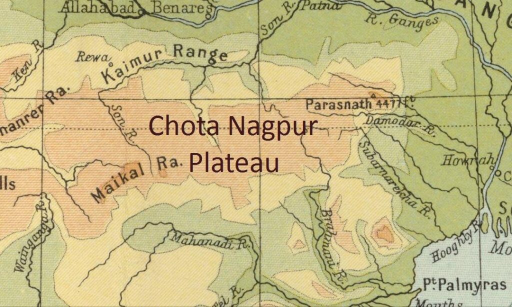
The Chota Nagpur Plateau is the largest of India’s mineral-bearing plateaus and arguably the most economically consequential physiographic region of eastern India. Lying mostly in Jharkhand with extensions into West Bengal, Odisha, Chhattisgarh, and Bihar, the Chota Nagpur Plateau covers roughly 65,000 square kilometres and forms the eastern projection of the larger Indian craton beyond the Vindhya range. It is built almost entirely on Archaean granites and gneisses, capped by erosional remnants of Gondwana sediments and the famous lateritic patlands that give the region its stepped silhouette. The Chota Nagpur Plateau is at once the mineral capital of India — supplying nearly all the country’s coking coal, large shares of iron ore, copper, mica, and bauxite — and the demographic heartland of central Indian tribal society. Understanding its geology, structure, and resource base is essential for any serious reading of peninsular India.
| Chota Nagpur Plateau — at a glance | Detail |
|---|---|
| Location | Mostly Jharkhand; extends into West Bengal, Odisha, Chhattisgarh and Bihar |
| Area | ~65,000 sq km |
| Elevation | 500–900 m (Parasnath Hill, 1,365 m, is the highest point) |
| Rock base | Archaean granite-gneiss (Chhotanagpur Granite Gneiss Complex) |
| Three patlands | Ranchi (lowest & largest), Hazaribagh, Koderma (highest) |
| Key resources | Coking coal (Damodar valley), iron ore, copper, mica, bauxite, uranium |
| Major rivers | Damodar, Subarnarekha, North & South Koel |
| Nickname | “Mineral capital of India” |
Location and Extent
The Chota Nagpur Plateau lies between roughly 21°N and 25°N latitude and 83°E and 87°E longitude. It is bounded by the Indo-Gangetic Plain to the north, the Mahanadi basin to the south, the Bengal basin to the east, and the Baghelkhand plateau to the west. Average elevations range from 500 to 900 metres, with the highest points on the Ranchi and Hazaribagh plateaus reaching above 1,100 metres. The plateau is the easternmost extension of the peninsular shield and represents the surface expression of the same Archaean basement that underlies much of central and southern India.
Administratively, the largest part of the Chota Nagpur Plateau lies in Jharkhand, where it covers almost the entire state. Smaller portions extend into Purulia and Bankura districts of West Bengal, the western parts of Odisha (Sundargarh, Keonjhar), the Surguja division of Chhattisgarh, and a small area of southern Bihar. The Mahanadi basin and the lower coastal plains of India lie immediately to its south.
Geological Foundation
The Chota Nagpur Plateau is built on some of the oldest rocks in the Indian subcontinent. The bulk of its surface is composed of Archaean granites, gneisses, and schists of the Chhotanagpur Granite Gneiss Complex (CGGC), formed between 3.3 billion and 850 million years ago. These crystalline rocks have been subjected to multiple episodes of metamorphism and deformation and form the structural skeleton of the entire plateau.
Gondwana Sediments and the Damodar Valley
The Archaean basement is unconformably overlain by Gondwana sedimentary rocks in a series of east–west troughs. The most important of these is the Damodar valley, which runs across the southern margin of the Chota Nagpur Plateau and hosts the Raniganj, Jharia, East Bokaro, West Bokaro, North Karanpura, and South Karanpura coalfields. The Damodar valley coalfields supply almost all of India’s prime coking coal and a substantial share of its thermal coal. The Damodar Gondwana basin contains rocks from the Talchir Formation at the base, through the Barakar (the main coal-bearing horizon), to the Raniganj Formation at the top.
Patlands as Lateritic Cap Rocks
The Chota Nagpur Plateau is famous for its stepped profile created by three principal upland surfaces locally called pats or patlands. A patland is a flat, lateritic-capped tableland produced by long-cycle weathering of the underlying granite-gneiss. The lateritic cap is resistant to erosion and protects the softer rocks below, giving the patlands their distinctive table-top form. The three main patland levels of the Chota Nagpur Plateau correspond to three erosion surfaces of different ages.
The Three Patlands of the Chota Nagpur Plateau
The Chota Nagpur Plateau is conventionally divided into three plateau surfaces, or patlands, each at a different elevation.
Ranchi Plateau
The Ranchi plateau is the southern and lowest of the three principal surfaces, with average elevations of 600 to 700 metres. It is the largest patland and includes the capital city of Ranchi. The plateau is drained by the Subarnarekha, the South Koel, and the upper Damodar. Several waterfalls — including Hundru, Dassam, Jonha, and Hirni — mark the edges of the Ranchi plateau, where rivers descend from the patland onto the lower plains. Hundru Falls on the Subarnarekha is the most famous, dropping 98 metres in a single leap.
Hazaribagh Plateau
The Hazaribagh plateau lies north of the Ranchi plateau and is separated from it by the Damodar valley. Average elevations are 600 to 800 metres, with Parasnath Hill rising to 1,365 metres at the eastern end. Parasnath is the highest peak in Jharkhand and a major Jain pilgrimage centre, associated with twenty of the twenty-four Tirthankaras. The Hazaribagh plateau is more rugged than the Ranchi plateau and hosts the Hazaribagh National Park and Tiger Reserve.
Koderma Plateau
The Koderma plateau lies north of the Hazaribagh plateau and is the highest of the three, with elevations of 800 to 1,100 metres in places. It is the principal mica-bearing region of India, with the Koderma–Giridih mica belt yielding the world’s finest sheet mica during the twentieth century. The plateau slopes northward and merges into the Ganga plain through a sharp scarp.
Mineral Wealth: The Mineral Capital of India
The Chota Nagpur Plateau is often called the mineral capital of India because of the unusual concentration of metallic and non-metallic minerals within a relatively small area. The Archaean crystalline rocks of the plateau contain ore-grade deposits of iron, copper, manganese, chromite, bauxite, mica, kyanite, and gold, while the Gondwana sediments of the Damodar valley hold the bulk of India’s coal.
Coal
The Damodar valley coalfields — Jharia, Raniganj, Bokaro, Karanpura — are the heart of India’s metallurgical coal supply. Jharia in particular is the only major source of prime coking coal in the country, essential for the integrated steel plants at Bokaro, Bhilai, Durgapur, and Rourkela.
Iron Ore, Copper, and Other Metals
The Singhbhum craton at the southern end of the Chota Nagpur Plateau hosts the Noamundi, Kiriburu, and Meghahatuburu iron ore deposits, as well as the Mosabani and Rakha copper belt. The Subarnarekha basin contains the world’s largest reserves of high-grade uranium ore at Jaduguda. Bauxite is mined extensively on the Ranchi and Pat plateaus, supplying the Hindalco aluminium plant at Muri. The Koderma–Giridih–Hazaribagh belt remains India’s primary mica-producing region, although demand has declined with the rise of synthetic substitutes.
Drainage and Waterfalls
The Chota Nagpur Plateau forms a major watershed in eastern India. Three principal river systems originate here: the Damodar (flowing east into the Hooghly), the Subarnarekha (flowing east into the Bay of Bengal), and the South Koel and North Koel (flowing west and north into the Brahmani and Sone). The plateau edges are marked by spectacular waterfalls where these rivers descend from the patlands. The most prominent include Hundru (98 m), Dassam (44 m), and Hirni (37 m), all on tributaries of the Subarnarekha and Damodar.
Climate, Vegetation, and Forests
The Chota Nagpur Plateau enjoys a more equable climate than the surrounding lowlands because of its elevation. Average annual rainfall ranges from 1,200 to 1,600 millimetres, concentrated in the south-west monsoon months of June to September. Natural vegetation is tropical moist and dry deciduous forest, dominated by sal (Shorea robusta), with mahua, kusum, and palash as common associates. The plateau still retains some of the largest contiguous sal forests in India, although fragmentation due to mining and agriculture has been severe.
Tribal Heartland of Central India
The Chota Nagpur Plateau is the demographic core of central Indian tribal society. Major Adivasi communities of the region include the Munda, Santhal, Ho, Oraon, Kharia, Birhor, Asur, and Mal Paharia. The Birhor and Asur communities are recognised as particularly vulnerable tribal groups (PVTGs) under the Government of India’s classification. The plateau gave rise to several major adivasi political movements, from the Kol insurrection of the 1830s and the Santhal Hul of 1855 to the Birsa Munda Ulgulan of 1899–1900 and the more recent Jharkhand statehood movement that culminated in the creation of Jharkhand in 2000.
Strategic and Economic Significance
The Chota Nagpur Plateau hosts some of the largest integrated industrial complexes in India. Bokaro, Jamshedpur, Rourkela, Durgapur, and Asansol all derive their existence from the combination of local coal, iron ore, and limestone within easy reach of one another. The Damodar Valley Corporation, modelled on the Tennessee Valley Authority and established in 1948, was India’s first multipurpose river valley project and continues to manage flood control, irrigation, and hydropower generation across the plateau. The Chota Nagpur Plateau is also a critical biodiversity zone within the larger Eastern Ghats–Deccan Plateau ecosystem.
Frequently Asked Questions
What is the Chota Nagpur Plateau and where is it located?
The Chota Nagpur Plateau is the largest plateau of eastern India, lying mostly in Jharkhand with extensions into West Bengal, Odisha, Chhattisgarh, and Bihar. It covers roughly 65,000 square kilometres and is bounded by the Indo-Gangetic Plain in the north, the Mahanadi basin in the south, the Bengal basin in the east, and the Baghelkhand plateau in the west.
Why is the Chota Nagpur Plateau called the mineral capital of India?
The Chota Nagpur Plateau hosts an extraordinary concentration of metallic and non-metallic minerals — coal (especially coking coal from Jharia), iron ore (Noamundi, Kiriburu), copper (Mosabani), bauxite, mica, uranium (Jaduguda), and gold. No comparable area in India contains so many industrially important minerals within so small a region, which is why the plateau supports the country’s largest steel and aluminium industries.
What are the three patlands of the Chota Nagpur Plateau?
The three principal patlands or plateau surfaces are the Ranchi plateau (the lowest and largest, with the capital of Jharkhand), the Hazaribagh plateau (between Damodar valley and Koderma, with Parasnath Hill), and the Koderma plateau (the highest, famous for mica). Each patland is a lateritic-capped tableland formed by long-cycle weathering of the underlying granite-gneiss.
What is the significance of the Damodar valley?
The Damodar valley is an east–west Gondwana sedimentary trough across the southern margin of the Chota Nagpur Plateau. It hosts the Jharia, Raniganj, Bokaro, and Karanpura coalfields, which supply nearly all of India’s coking coal. It is also the site of the Damodar Valley Corporation, India’s first multipurpose river valley project, established in 1948.
Which are the major waterfalls of the Chota Nagpur Plateau?
The most famous waterfalls on the Chota Nagpur Plateau are Hundru Falls (98 m) on the Subarnarekha, Dassam Falls (44 m) on the Kanchi, Jonha Falls (43 m) on the Gunga, and Hirni Falls (37 m) on the Banai. All occur where rivers descend from the higher patland surfaces onto the lower plateau levels.
Which tribal communities live on the Chota Nagpur Plateau?
The plateau is the heartland of central Indian Adivasi society. Major communities include the Munda, Santhal, Ho, Oraon, Kharia, Birhor, Asur, and Mal Paharia. The Birhor and Asur are recognised as Particularly Vulnerable Tribal Groups. The region has produced several major tribal uprisings, from the Santhal Hul of 1855 to the Birsa Munda Ulgulan of 1899–1900.
How does the Chota Nagpur Plateau differ from the Deccan Plateau?
The Chota Nagpur Plateau is a smaller eastern plateau dominated by Archaean granites and gneisses and a thick concentration of Gondwana coal in the Damodar valley. The Deccan Plateau is much larger, covers most of peninsular India, and is dominated by Cretaceous–Paleogene Deccan Traps basalt over an older crystalline basement.
What is the climate and natural vegetation of the Chota Nagpur Plateau?
The plateau receives 1,200 to 1,600 mm of annual rainfall, concentrated in the south-west monsoon. Elevation moderates summer temperatures compared to the surrounding lowlands. The natural vegetation is tropical moist and dry deciduous forest, dominated by sal (Shorea robusta) with mahua, kusum, and palash. The plateau retains some of the largest contiguous sal forests in India, though mining and agriculture have caused significant fragmentation.
Tell Google you want more of this.
Add Anantam IAS as a preferred sourceOne tap, and this site shows up more often in your own Top Stories, AI Overviews and AI Mode. Remove it any time.






