Introduction
India operates the second largest road network in the world, stretching over 6.6 million kilometres and carrying roughly two thirds of all freight and nearly nine out of every ten passenger trips made in the country. At the top of this network sits the national highway system, a backbone of high capacity corridors that link the metros, ports, state capitals and border regions. Though national highways account for barely 2 per cent of the total road length, they carry more than 40 per cent of all road traffic. For an economy of India’s scale, the performance of this small layer decides the competitiveness of every other sector.
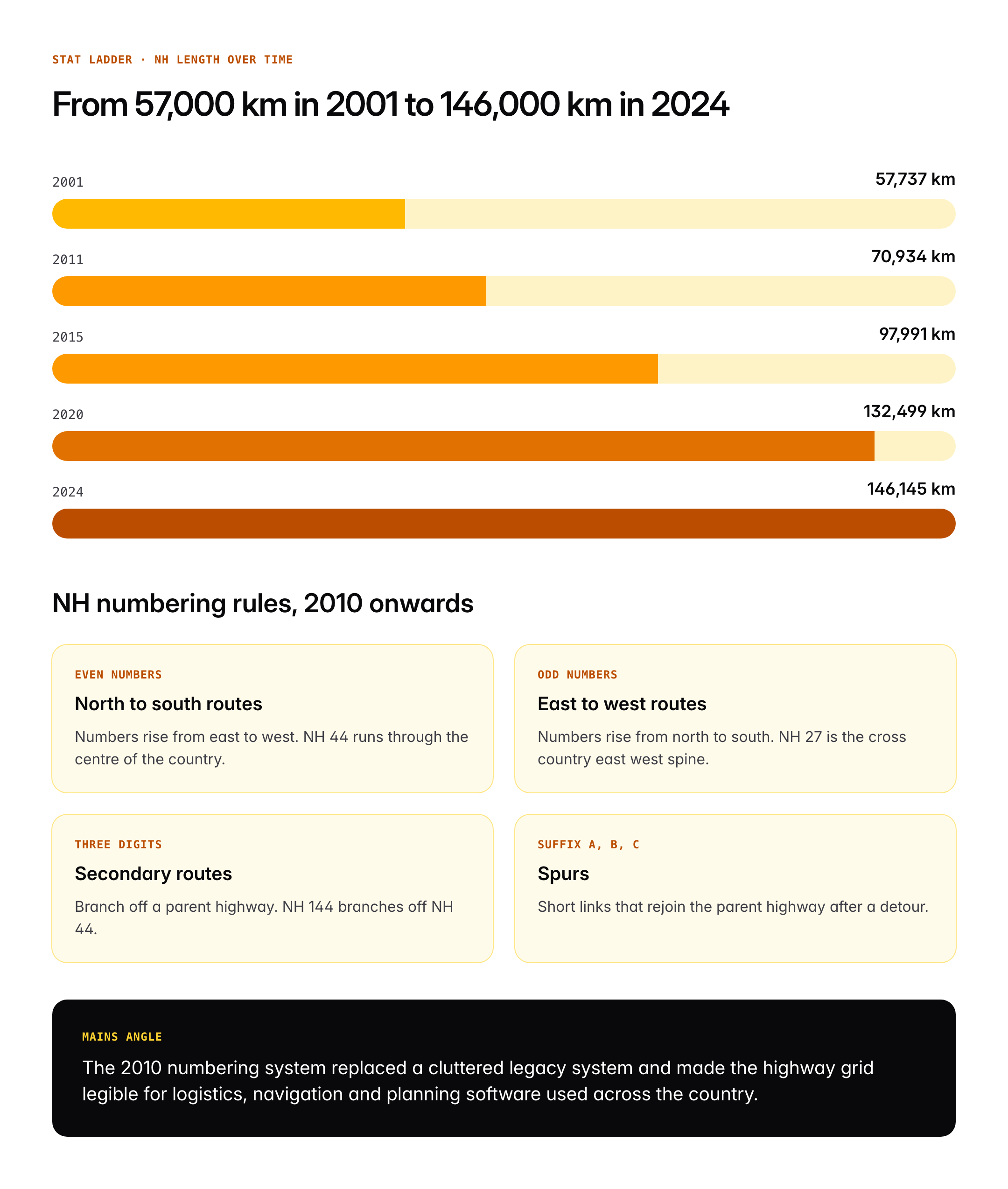
The national highway system has changed almost beyond recognition in the last twenty five years. From roughly 57,000 kilometres in 2001, the network has grown past 146,000 kilometres in 2024 as per Ministry of Road Transport and Highways data. The Golden Quadrilateral, North South and East West corridors and the current Bharatmala Pariyojana have each added scale, capacity and access. For UPSC aspirants, this subject sits at the intersection of infrastructure, federal finance, environment and regional development, making it a perennial favourite in GS3 Economy questions.
Quick Facts at a Glance
| Field | Detail |
|---|---|
| Total road network | Over 6.6 million km, second largest globally |
| National highway length | 146,145 km (as on 31 March 2024, MoRTH) |
| Share of traffic | Over 40 per cent on just 2 per cent of road length |
| Nodal ministry | Ministry of Road Transport and Highways |
| Main implementation body | National Highways Authority of India (NHAI) |
| NHAI constituted | 1988, operational from February 1995 |
| First highway built after independence | NH 1 Delhi to Attari, via Amritsar |
| Longest national highway | NH 44, Srinagar to Kanyakumari, 3,806 km |
| Major programme | Bharatmala Pariyojana, approved 2017 |
| Golden Quadrilateral length | 5,846 km |
| Funding | Cess on petrol and diesel, toll, external loans, InvIT |
Background and Historical Context
The idea of a planned national road network in India goes back to the Nagpur Plan of 1943, which first classified Indian roads into national highways, state highways, district roads, village roads and expressways. The plan set a target of one kilometre of road per nine square kilometres of area. The Bombay Plan of 1961 and the Lucknow Plan of 1981 refined the framework. However, for the first four decades after independence, investment in roads remained modest, with railways treated as the premier mode for both freight and long distance passengers.
The decisive shift came in 1988 with the enactment of the National Highways Authority of India Act, which created a statutory body dedicated to the development, maintenance and management of national highways. NHAI became operational in February 1995 and took charge of the most important programme of Indian infrastructure in the next decade, the National Highways Development Project, launched in 1998. The NHDP had seven phases. Phase I, the Golden Quadrilateral connecting Delhi, Mumbai, Chennai and Kolkata, was completed in stages between 2001 and 2012. Phase II added the North South and East West corridors.
By the mid 2010s, NHDP was considered largely saturated, and the government launched a new umbrella programme. Bharatmala Pariyojana, approved by the Union Cabinet in October 2017, set a target of 34,800 kilometres of new national highways in Phase I at an estimated cost of 5.35 lakh crore rupees. It introduced the idea of economic corridors, inter corridor and feeder routes, border and international connectivity roads, coastal and port connectivity, and expressways. Parallel programmes such as the Setu Bharatam bridges programme, the Char Dham Pariyojana, and the North East Special Accelerated Road Development Programme address specific gaps.
Key Features of the National Highway System
Classification
National highways are classified in several overlapping ways. By administrative jurisdiction, all declared NHs are under the central government, though physical implementation may be delegated to the state Public Works Department, to NHAI, to the National Highways and Infrastructure Development Corporation or to a state Border Roads Organisation. By number of lanes, they are labelled as single lane, intermediate lane, two lane, four lane, six lane and eight lane. By role, they are classified as economic corridors, inter corridor routes, feeder routes, national corridors, border roads, international connectivity roads, coastal and port connectivity roads, and expressways.
Numbering Rules
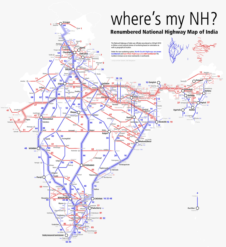
India adopted a new national highway numbering system in 2010, notified by MoRTH in April 2010. The rules are systematic.
- North to south highways carry even numbers, increasing from east to west. NH 2 is near the east coast, NH 44 runs through the middle.
- East to west highways carry odd numbers, increasing from north to south. NH 27 is in the north, NH 65 is further south.
- Three digit numbers indicate secondary routes that branch off from a parent highway. For example NH 44 has branches like NH 144, NH 244 and NH 344.
- Suffix letters A, B, C denote spurs that rejoin the parent highway.
The Backbone Corridors
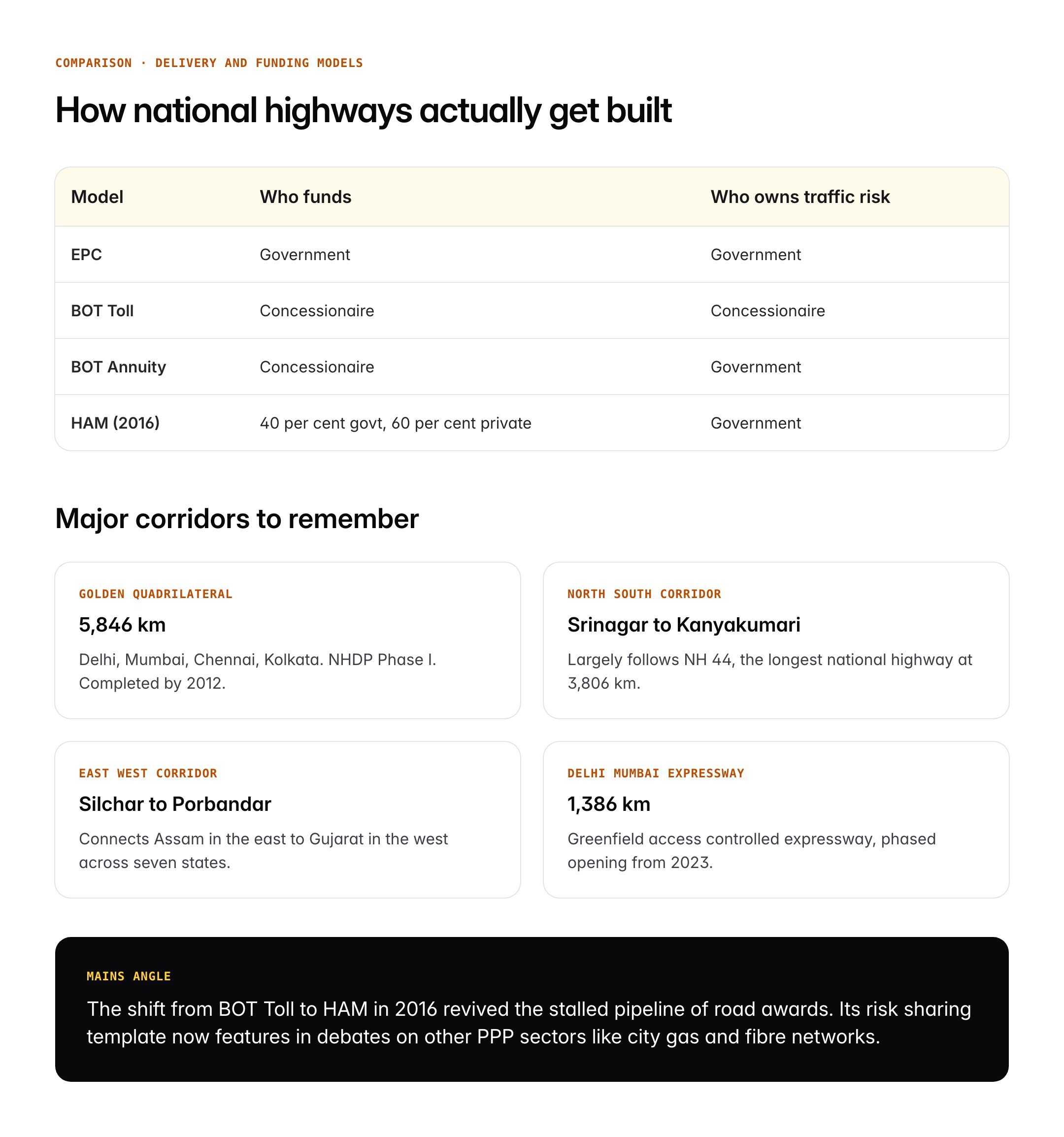
- Golden Quadrilateral: 5,846 km connecting Delhi, Mumbai, Chennai, Kolkata. Completed in stages by 2012.
- North South Corridor: Srinagar to Kanyakumari, largely along NH 44.
- East West Corridor: Silchar to Porbandar, across seven states.
- Delhi Mumbai Expressway: 1,386 km greenfield expressway, phased opening from 2023.
- Bengaluru Chennai Expressway: 262 km, opening in phases by 2025.
NHAI and Funding
National Highways Authority of India is the central public sector undertaking that plans, finances and manages national highways handed over to it. Its funding sources include a cess on petrol and diesel, user fee collections at toll plazas under the Fee Rules 2008, external aid from the World Bank, Asian Development Bank and Japan International Cooperation Agency, and since 2020 monetisation through the National Monetisation Pipeline and the first highways Infrastructure Investment Trust launched in 2021.
Project Delivery Models
- Engineering Procurement Construction (EPC): Government funds the project, contractor executes for a fixed fee.
- Build Operate Transfer (BOT) Toll: Private concessionaire invests, collects toll, transfers the asset after the concession.
- BOT Annuity: Government pays fixed annuity to the concessionaire, irrespective of traffic.
- Hybrid Annuity Model (HAM): Introduced 2016. Government funds 40 per cent during construction, concessionaire arranges the rest and receives annuity and O&M payments.
Significance for UPSC and General Knowledge
- National highways carry over 40 per cent of road traffic on just 2 per cent of road length, making them the arterial network of the Indian economy.
- Bharatmala Pariyojana links economic geography to corridor planning, replacing a purely length based approach with origin destination analysis.
- The highway system enables Prime Minister Gati Shakti’s multi modal planning by providing the backbone for rail, port and logistics integration.
- Highway quality influences logistics cost as a share of GDP, targeted to fall from around 14 per cent to below 10 per cent by 2030 under the National Logistics Policy 2022.
- FASTag penetration crossed 98 per cent of all national highway electronic toll collection by 2024, a direct test case for digital public infrastructure.
Detailed Analysis of Major Programmes and Corridors
The Golden Quadrilateral was the single most transformative highway project in post liberalisation India. At 5,846 kilometres, it connected the four megacities of Delhi, Mumbai, Chennai and Kolkata with four to six lane divided carriageway. A 2014 NCAER evaluation found that districts lying within fifty kilometres of the Quadrilateral saw manufacturing growth roughly forty nine per cent higher than comparable non proximate districts. The project catalysed the rise of secondary manufacturing hubs at Bawal, Chakan, Oragadam and Rajarhat.
Bharatmala Pariyojana Phase I, approved in 2017 for 34,800 kilometres at 5.35 lakh crore rupees, brought a deliberate economic corridor approach. MoRTH identified 50 economic corridors, 24 inter corridor routes and 66 feeder routes, based on freight origin destination studies. By March 2024, over 27,000 kilometres had been awarded, though execution faced delays due to land acquisition disputes and environmental clearances. Phase II of Bharatmala is under preparation.
The expressways programme is a newer emphasis. Unlike traditional national highways, expressways are access controlled, fully divided, typically six or eight lane facilities with no at grade intersections. The Delhi Mumbai Expressway, the Ganga Expressway in Uttar Pradesh, the Dwarka Expressway linking Delhi and Gurugram, and the Bengaluru Chennai Expressway are flagship projects. The government has indicated a target of 50,000 kilometres of national highways with four or more lanes by 2037, of which a significant share will be expressways.
A parallel priority is border and coastal connectivity. Roads in Ladakh, Arunachal Pradesh and Sikkim have been taken up under Bharatmala and by the Border Roads Organisation, including the Sela Tunnel inaugurated in 2024 and the Zojila Tunnel under construction. The Sagarmala programme under the Ministry of Ports, Shipping and Waterways feeds port connectivity requirements into the highway planning pipeline.
Comparative Perspective
| Country | Total road network | Expressway or NH length | Length per thousand sq km |
|---|---|---|---|
| India | 6.6 million km | 146,145 km NH | 2,010 km |
| United States | 6.8 million km | 78,600 km Interstate | 730 km |
| China | 5.2 million km | 177,000 km expressway | 540 km |
| Brazil | 1.7 million km | 65,000 km federal | 200 km |
Source: MoRTH Basic Road Statistics, International Road Federation, national ministries. India’s per area road density is high, but the share of expressway grade roads remains below comparable countries. The Chinese expressway network, built over roughly the same period as Indian NHDP, is larger in total length but serves a far more concentrated urban and industrial belt. Indian planners have consciously emphasised coverage and connectivity of smaller cities in addition to corridor capacity.
Challenges and Criticisms
The highway programme faces four persistent problems. First, land acquisition, governed by the Right to Fair Compensation and Transparency in Land Acquisition Act 2013, continues to cause delays. MoRTH data shows land acquisition is the single largest reason for stalled projects. Second, road safety remains grim. According to the Road Accidents in India report by MoRTH, national highways accounted for roughly 33 per cent of all road accidents and a similar share of fatalities in 2022, though they carry a smaller share of total road users.
Third, the financial model of NHAI has attracted scrutiny. The Comptroller and Auditor General in its 2023 performance audit flagged rising borrowings and the reliance on asset monetisation to service debt. A CAG follow up in 2024 recommended a more conservative debt ceiling and a restructured financial framework. Fourth, environmental concerns, including deforestation in hill states and impact on wildlife corridors, have led to judicial intervention. The Supreme Court in the Char Dham Pariyojana case directed compliance with a revised width norm in ecologically sensitive zones.
A related debate concerns the toll plaza model and traffic diversion. While FASTag has sharply reduced waiting times, tolling on rural bypasses has generated localised protests, leading MoRTH to consider a satellite based GNSS tolling regime notified on a pilot basis in 2023.
Prelims Pointers
- The new national highway numbering system was notified in April 2010.
- NH 44, from Srinagar to Kanyakumari, is the longest national highway at 3,806 km.
- Golden Quadrilateral is 5,846 km long.
- Bharatmala Pariyojana Phase I was approved in October 2017.
- Hybrid Annuity Model was introduced in 2016.
- NHAI was created by the NHAI Act 1988 and became operational in February 1995.
- As of 31 March 2024, India had 146,145 km of declared national highways.
- FASTag penetration on toll plazas crossed 98 per cent by 2024.
- The National Logistics Policy was launched in September 2022.
- The Sela Tunnel in Arunachal Pradesh was inaugurated in March 2024.
- The Delhi Mumbai Expressway is 1,386 km long.
- National highways carry over 40 per cent of road traffic on about 2 per cent of road length.
Mains Practice Questions
- Discuss the role of the national highway system in driving economic growth and regional balance in India. What are the key challenges in accelerating highway development?
- Cite the Golden Quadrilateral impact studies linking highway proximity to manufacturing growth.
- Explain Bharatmala’s corridor approach and its integration with Gati Shakti and National Logistics Policy.
- Highlight land acquisition, road safety and financial sustainability of NHAI as the main challenges.
- Examine the funding and delivery models used in Indian national highway projects. How has the Hybrid Annuity Model changed the risk allocation between government and private investors?
- Compare EPC, BOT Toll, BOT Annuity and HAM on risk allocation.
- Describe how HAM addressed the 2014 slowdown in private participation.
- Discuss the role of asset monetisation and the InvIT route in freeing fresh capital.
Conclusion
The Indian national highway system is a live example of how physical infrastructure can reshape an economy. In a single generation, the share of goods moving by road has risen, secondary cities have emerged as industrial nodes, and logistics costs have begun to fall. Yet the job is far from complete. Road safety, environmental sensitivity, financial sustainability and the transition from length to quality remain open challenges that will define the next phase of highway policy.
For the UPSC aspirant, mastery of this subject requires more than memorising highway numbers. It requires understanding how corridors are planned, how projects are financed, how risks are allocated between public and private actors, and how highway investment interacts with federal finance and environmental regulation. These threads run through questions in GS3 on infrastructure and in the Essay paper on development models, and they will remain relevant as India moves towards a targeted 50,000 kilometres of four or more lane national highways by 2037.
Frequently Asked Questions
What is the Indian national highway system?
The Indian national highway system is the network of highways notified by the central government under the Ministry of Road Transport and Highways. As on 31 March 2024 it spans 146,145 kilometres, carries over 40 per cent of road traffic on about 2 per cent of total road length, and forms the arterial grid connecting metros, ports, state capitals and border regions of India.
Why is the national highway system important for UPSC preparation?
Highways cut across GS3 infrastructure, GS2 government schemes and the Economy section of GS3. Programmes like Bharatmala, delivery models like the Hybrid Annuity Model, and issues like road safety and land acquisition frequently feature in Prelims and Mains. Highways also anchor questions on Gati Shakti and the National Logistics Policy 2022.
How is NH numbering related to direction in India?
Under the 2010 numbering rules, north south highways carry even numbers that rise from east to west, east west highways carry odd numbers that rise from north to south, three digit numbers are branches of a parent highway, and suffix letters A, B and C denote spurs. NH 44 from Srinagar to Kanyakumari is the longest, at 3,806 kilometres.
What is Bharatmala Pariyojana?
Bharatmala Pariyojana is an umbrella road programme approved by the Union Cabinet in October 2017 with a Phase I target of 34,800 kilometres of national highways at 5.35 lakh crore rupees. It emphasises economic corridors, inter corridor and feeder routes, border and coastal connectivity, and expressways, replacing the earlier length based approach with origin destination freight analysis.
What is the role of NHAI?
The National Highways Authority of India is a statutory body created by the NHAI Act 1988 and operational from February 1995. It plans, finances and manages the national highways handed over to it by the Ministry of Road Transport and Highways. Its funding comes from a fuel cess, toll collections, external loans and asset monetisation through InvIT.
How is the Hybrid Annuity Model different from BOT Toll?
In Build Operate Transfer Toll, the private concessionaire invests the entire project cost and recovers it from tolls, bearing full traffic risk. In the Hybrid Annuity Model introduced in 2016, the government funds 40 per cent of the cost during construction and the private party arranges the rest, receiving fixed annuities plus operation and maintenance payments. HAM has sharply reduced private risk and revived road awards.
What is the Golden Quadrilateral?
The Golden Quadrilateral is a 5,846 kilometre network of four to six lane highways connecting Delhi, Mumbai, Chennai and Kolkata, executed as Phase I of the National Highways Development Project launched in 1998. Most of it was completed between 2001 and 2012. Studies have linked proximity to the Quadrilateral to significantly higher manufacturing growth in surrounding districts.
What are the main challenges facing the Indian national highway system?
The principal challenges are land acquisition delays under the 2013 law, road accidents that make NHs responsible for roughly one third of road fatalities, financial sustainability of NHAI with rising borrowings, and environmental impact in ecologically sensitive zones like the Char Dham corridor. Expanding expressway grade roads and moving to GNSS based tolling are emerging policy directions.