Why in News?
On 20 August 2026, the Ministry of Earth Sciences released CMLRE’s national report synthesising deep-sea fishery and ecological research across India’s Exclusive Economic Zone.
- The report compiles nearly four decades of research and three decades of systematic surveys across India’s 2.37 million square kilometre EEZ.
- Its evidence base includes more than 400 oceanographic cruises since the early 1990s under the Marine Living Resources Programme.
- It assesses mesopelagic communities, continental-slope resources, open-ocean species and ecologically important nursery and habitat areas.
- The synthesis combines historical observations with acoustics, eDNA, satellites, autonomous platforms, artificial intelligence and ecosystem modelling.
- The report is a scientific assessment, not permission to harvest every identified stock or proof that exploitation would be commercially viable.
- Deep-sea evidence can reduce uncertainty in fishery policy, but abundance estimates must be read alongside reproduction, food-web roles, habitat sensitivity and monitoring capacity.
- The report connects food security and economic opportunity with SDG 14, biodiversity conservation and the ocean’s role in climate regulation.
- Marine spatial planning can separate potential fishing grounds, sensitive habitats, research zones and competing ocean uses before investments create ecological lock-in.
UPSC Relevance
Prelims Relevance
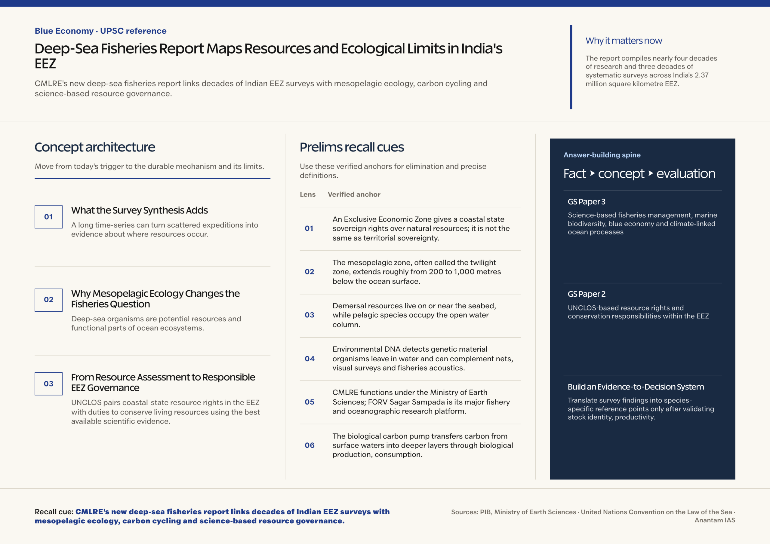
- An Exclusive Economic Zone gives a coastal state sovereign rights over natural resources; it is not the same as territorial sovereignty.
- The mesopelagic zone, often called the twilight zone, extends roughly from 200 to 1,000 metres below the ocean surface.
- Demersal resources live on or near the seabed, while pelagic species occupy the open water column.
- Environmental DNA detects genetic material organisms leave in water and can complement nets, visual surveys and fisheries acoustics.
- CMLRE functions under the Ministry of Earth Sciences; FORV Sagar Sampada is its major fishery and oceanographic research platform.
- The biological carbon pump transfers carbon from surface waters into deeper layers through biological production, consumption, migration and sinking material.
Mains Relevance
GS Paper 3
- Science-based fisheries management, marine biodiversity, blue economy and climate-linked ocean processes
- Balancing resource use with precaution, habitat protection and long-term monitoring
GS Paper 2
- UNCLOS-based resource rights and conservation responsibilities within the EEZ
- Institutional coordination between science agencies, fishery regulators and coastal stakeholders
Essay
- The blue economy becomes durable only when scientific knowledge sets ecological limits before extraction decisions are made.
Background and Context
What the Survey Synthesis Adds
A long time-series can turn scattered expeditions into evidence about where resources occur, how environments vary and which knowledge gaps remain.
- The synthesis brings together species distribution, abundance and environmental observations collected across the Arabian Sea, Bay of Bengal, island waters and adjoining deep-sea systems.
- Repeated cruises help distinguish persistent patterns from a single-season observation, although survey coverage, seasonal timing, gear selectivity and species detectability still shape every estimate.
- Fisheries acoustics can infer the distribution of organisms from sound reflections, while sampling is needed to identify species and calibrate acoustic signals.
- eDNA and autonomous platforms can expand observation across difficult waters, but neither replaces taxonomic expertise, physical samples or transparent uncertainty ranges.
- Satellite observations add surface context such as productivity and ocean conditions; ecosystem models connect these inputs to food webs and management scenarios.
Why Mesopelagic Ecology Changes the Fisheries Question
Deep-sea organisms are potential resources and functional parts of ocean ecosystems, so biomass alone cannot define a safe harvest level.
- The mesopelagic layer between about 200 and 1,000 metres supports lanternfishes, shrimps, cephalopods and predators linked through complex food webs.
- Many organisms migrate upward at night to feed and return to deeper water, moving consumed carbon below the sunlit surface.
- This vertical migration contributes to the biological carbon pump, which helps store carbon at depth and links fishery decisions with climate regulation.
- Removing a forage species can affect predators, prey competition and carbon transport even when the target appears abundant, making cumulative ecosystem effects relevant before commercial scaling.
- Deep-water species may grow slowly, mature late or recover unevenly; such life-history traits can make depletion difficult to reverse.
From Resource Assessment to Responsible EEZ Governance
UNCLOS pairs coastal-state resource rights in the EEZ with duties to conserve living resources using the best available scientific evidence.
- A resource estimate describes potential abundance under stated methods and assumptions; it does not establish allowable catch, profitability or ecosystem-safe extraction by itself.
- Managers need stock structure, recruitment, bycatch, habitat impacts, predator dependence, climate variability and enforcement capacity before setting effort, gear, season or area rules.
- Documented banks, slopes, terraces and island habitats may function as nurseries or biodiversity hotspots, strengthening the case for spatial safeguards and baseline monitoring.
- Adaptive management should begin with cautious pilots, independent observation and review triggers rather than committing capacity before ecological response is understood.
- Transparent data, uncertainty statements and stakeholder participation can align research institutions, regulators and fishing communities around enforceable limits and shared evidence.
Way Forward
Build an Evidence-to-Decision System
- Translate survey findings into species-specific reference points only after validating stock identity, productivity, food-web role and uncertainty.
- Use marine spatial planning to protect sensitive habitats and separate fishing, conservation, research, shipping and energy uses.
- Require vessel monitoring, bycatch reporting, independent observers and periodic stock reassessment before expanding any deep-sea fishery.
- Publish methods and non-sensitive datasets so researchers and coastal stakeholders can test assumptions and identify emerging ecological risks.
Conclusion
- The report’s main value is a national evidence base connecting resource possibilities with mesopelagic food webs, carbon transfer and vulnerable habitats, rather than a catalogue of commercially available fish stocks.
- In a Mains answer, distinguish assessment from authorisation: use the report to support precautionary, spatially informed and continuously monitored management within India’s EEZ.
- A credible blue-economy pathway must make ecological thresholds, uncertainty and recovery capacity as visible in investment decisions as estimated biomass and potential economic value, protecting long-term food security from short-lived gains.
UPSC Practice Questions
Prelims MCQ 1
With reference to the mesopelagic zone and the biological carbon pump, consider the following statements:
- The mesopelagic zone generally extends from about 200 to 1,000 metres below the ocean surface.
- Daily vertical migration by marine organisms can transport carbon from surface waters to deeper layers.
- Every organism detected in this zone can be treated as commercially harvestable biomass.
How many of the above statements are correct?
(a) Only one (b) Only two (c) All three (d) None
Answer: (b) Only two
Explanation:
Statements 1 and 2 are correct. Detection or abundance does not establish commercial viability or ecological harvestability; life history, food-web roles and uncertainty must also be assessed.
Prelims MCQ 2
Which one of the following best describes a coastal state’s position in its Exclusive Economic Zone under UNCLOS?
(a) It possesses complete territorial sovereignty identical to its land territory (b) It has sovereign rights over natural resources along with conservation and management responsibilities (c) It may exploit all living resources without considering scientific evidence (d) Foreign navigation is prohibited unless the coastal state grants individual permission
Answer: (b) It has sovereign rights over natural resources along with conservation and management responsibilities
Explanation:
UNCLOS grants resource-related sovereign rights and jurisdiction in specified matters within the EEZ, while requiring conservation based on the best available scientific evidence.
UPSC Mains Questions
- A deep-sea resource assessment should be treated as the beginning of fisheries governance, not as an extraction licence. Discuss with reference to India’s EEZ.
- Explain how mesopelagic organisms connect marine food security, biodiversity and the biological carbon pump. What safeguards should guide any new fishery?
Sources: PIB, Ministry of Earth Sciences and United Nations Convention on the Law of the Sea.
Frequently Asked Questions
What is new about the CMLRE deep-sea fisheries report?
It consolidates decades of Indian oceanographic surveys into a national assessment of deep-sea resources, habitats, mesopelagic ecology and tools for science-based marine planning.
Does the report authorise commercial extraction?
No. A scientific assessment estimates resources and ecological conditions. Regulators still need stock reference points, impact safeguards, monitoring and legally valid management decisions.
What is the mesopelagic zone?
It is the low-light ocean layer roughly 200 to 1,000 metres deep, inhabited by lanternfishes, shrimps, cephalopods and other organisms that support deep food webs.
How do mesopelagic organisms support the biological carbon pump?
Many feed near the surface at night and return to depth, transporting consumed carbon downward through respiration, waste, predation and sinking biological material.
Why is marine spatial planning relevant to fisheries?
It helps allocate ocean space among fishing, conservation, research and other uses while protecting nurseries, vulnerable habitats and ecological processes identified by scientific surveys.
Tell Google you want more of this.
Add Anantam IAS as a preferred sourceOne tap, and this site shows up more often in your own Top Stories, AI Overviews and AI Mode. Remove it any time.