Why in News?
The Centre government has asserted that the Great Nicobar Project is a “strategic necessity” to strengthen India’s footprint in the Indo-Pacific and reduce reliance on foreign transhipment ports.
| UPSC Relevance: GS-3 Economy: Infrastructure; GS-3 Environment and Biodiversity: Conservation; GS-3 Internal Security Prelims & Mains: The Great Nicobar Project: Location, concerns & significance. |
Great Nicobar Island: Location & Geographic Significance
- The Great Nicobar Island is the southernmost and largest island of the Nicobar archipelago, covering 910 sq km. It is home to Indira Point, the southernmost tip of India, located barely 150 km from Sumatra, Indonesia.
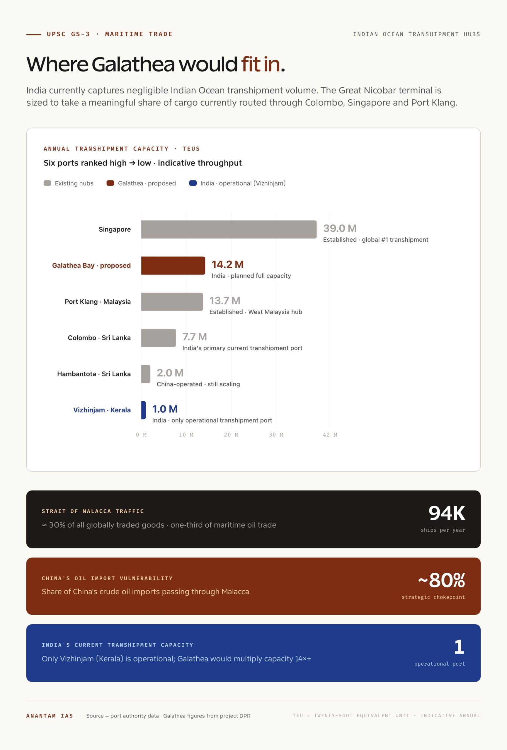
- Strategically located near the Strait of Malacca (the narrow maritime choke point through which 94,000 ships pass annually, accounting for roughly 30% of all globally traded goods and one-third of the world’s maritime oil trade).
- The island is part of the Great Nicobar Biosphere Reserve, harbouring rich ecosystems such as littoral/coastal wetland forests, mixed evergreen forests, and evergreen hill forests.
- Biogeographically, it falls within the Sundaland Biodiversity Hotspot (one of the world’s 36 biodiversity hotspots), making it ecologically significant.
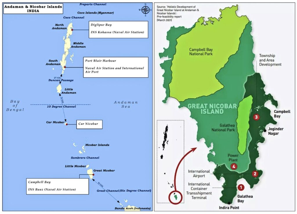
What is the Great Nicobar Project?
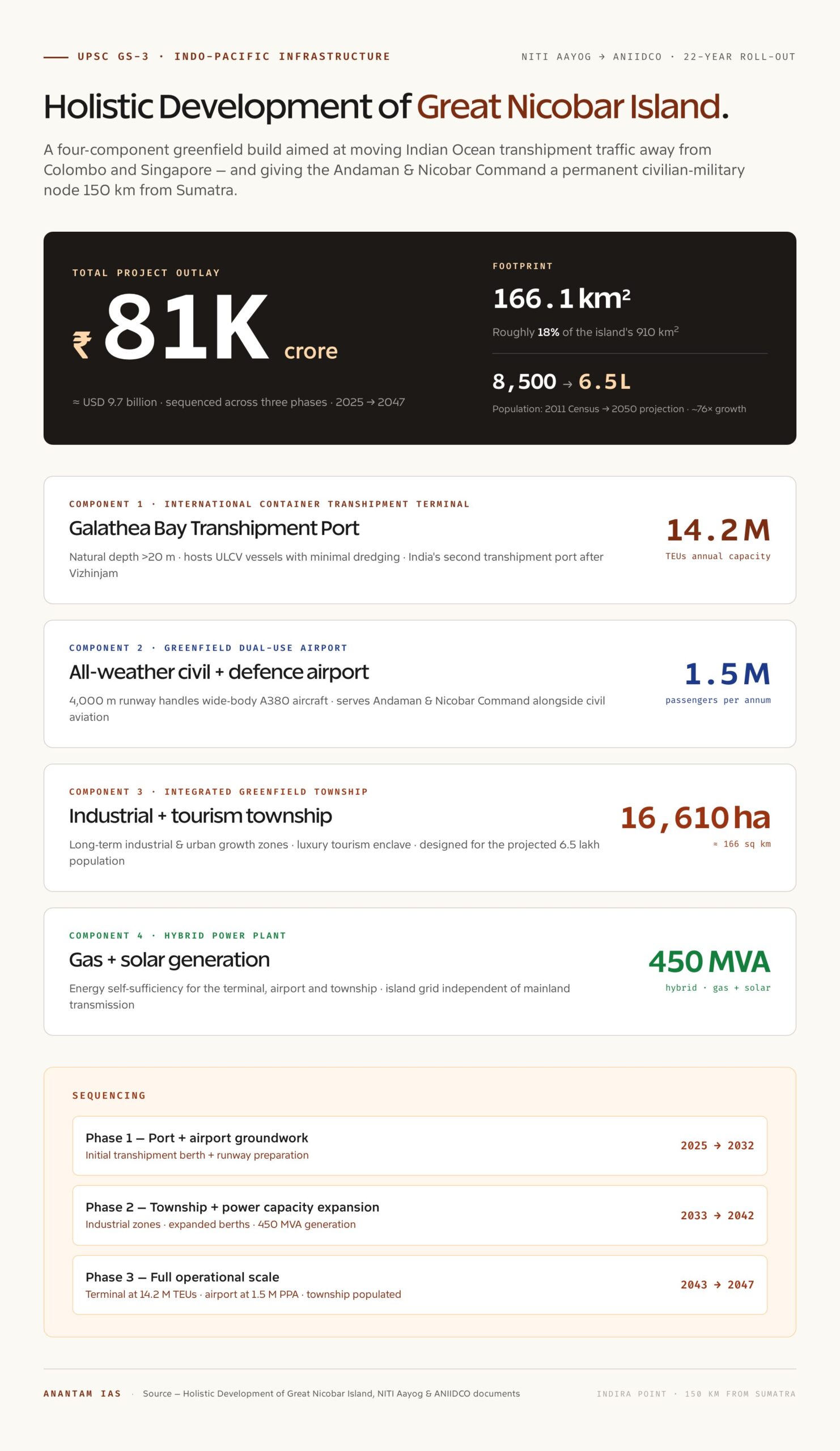
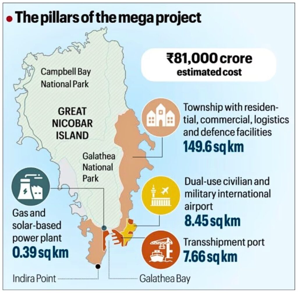
- The Great Nicobar Island (GNI) project, formally known as the “Holistic Development of Great Nicobar Island,” is an estimated ₹81,000 crore mega-infrastructure initiative.
- Aim: To transform the island into a strategic and economic hub for the Indo-Pacific region. The project spans 166.1 sq km across three phases from 2025 to 2047. This 166.10 sq. km represents roughly 18% of the total land area of the Great Nicobar Island.
- Conceived by NITI Aayog and now being implemented by the Andaman and Nicobar Islands Integrated Development Corporation (ANIIDCO).
Key Infrastructure Projects planned:
- Transhipment Port at Galathea Bay: Developing an International Container Transhipment Terminal (ICTT) to handle up to 14.2 million TEUs annually. It leverages a natural water depth of over 20 metres, allowing it to host large vessels without major dredging. It is designed to capture a share of the Indian Ocean cargo market, currently dominated by regional hubs like Singapore, Colombo, Port Klang, and Hambantota. India currently possesses only one operational transhipment port (Vizhinjam, Kerala).
- Dual-Use Airport: A greenfield international airport with all-weather operational capability. It will serve both civil aviation and strategic defence purposes (dual-use). Planned with a 4,000-metre runway capable of handling wide-body aircraft (like the Airbus A380) and serving an estimated 1.5 million passengers per annum (MPPA).
- Integrated Township: A new “greenfield city” spanning approximately 16,610 hectares (roughly 166 sq km). Designed to support long-term industrial and urban growth, including luxury tourism and industrial zones.
- Power Plant: A 450 MVA hybrid power plant. Primarily gas and solar-based to provide reliable, high-quality energy for the terminal, airport, and township while ensuring energy self-sufficiency.
The project also envisions the island’s population growing from the current ~8,500 (2011 Census) to an estimated 6.5 lakh by 2050.
Strategic & Economic Significance:
- Geopolitical Rationale: It is India’s “String of Pearls” counter-strategy against China’s growing naval presence in the Indian Ocean. The island provides a forward base to monitor the Malacca Strait, through which ~80% of China’s oil imports pass.
- Maritime Trade: India loses significant transhipment revenue to foreign ports. The Galathea Bay terminal is projected to handle 14.2 million TEUs annually, making India a regional logistics hub and reducing port dependency on Colombo and Singapore.
- Defence Infrastructure: Strengthens the Andaman & Nicobar Command (operational since 2001). The project is critical to India’s military footprint in the Indo-Pacific.
- Act East Policy: The project is a physical expression of India’s Act East Policy, integrating the island into Southeast Asian trade networks. It counters foreign power encroachment by establishing a permanent civilian and military presence at a key oceanic node.
Controversies and Concerns:
Despite receiving environmental and legal clearances, the project remains deeply contested across ecological, tribal, and seismic dimensions.
Editorial note · the irreplaceability problem
On forest accounting, both sides are technically right. The government’s “1.82% of all A&N forests” figure is correct at the territorial scale; the critics’ “7.11 lakh trees and 130.75 sq km of pristine Sundaland rainforest” figure is correct at the project scale. The substantive disagreement is whether compensatory afforestation in the Aravalli scrub of Haryana is ecologically equivalent to a unique island rainforest in one of the world’s 36 biodiversity hotspots. The Forest Conservation Act treats them as fungible hectares; ecologists do not. This is a real, not rhetorical, fault line.
Editorial note · the strategic case
The strategic logic — a forward base 150 km from Sumatra, persistent presence near a chokepoint that carries roughly 30% of world trade — is genuine and not new. India’s Andaman & Nicobar Command has operated since 2001 precisely because this geography matters. The harder questions are about scale and cost: does this specific civilian build (₹81,000 crore, 166 sq km, projected 6.5 lakh population) follow from the strategic premise, or do leaner military upgrades deliver the same deterrence at a fraction of the ecological footprint? UPSC answers that engage this proportionality question score better than ones that merely assert the strategic rationale.
- Forest loss: 130.75 sq km of pristine forest will be diverted, involving felling of up to 7.11 lakh trees in the first two phases.
- Denotification of sanctuaries: The Galathea Bay Wildlife Sanctuary and the Megapode Wildlife Sanctuary were denotified to make way for the project.
- Impact on Fauna:
- Leatherback Turtles: The port at Galathea Bay will directly impact nesting sites of the Critically Endangered Giant Leatherback Turtle — one of the world’s oldest and largest sea turtle species.
- Nicobar Megapode: A ground-dwelling bird found only on the Nicobar islands (IUCN: Vulnerable), its nesting mounds will be disrupted by construction in the project area.
- Compensatory afforestation outside UT: The Compensatory Afforestation plan proposes planting in Haryana and Madhya Pradesh, which is a biologically incompatible replacement for a unique island rainforest ecosystem.
- Tribal Rights Concerns: The Shompen Tribe (a Particularly Vulnerable Tribal Group of ~250 hunter-gatherers with minimal outside contact) inhabits forests within the project zone. Experts have warned of catastrophic disease exposure and cultural disruption.
- Seismic Vulnerability: The island lies in Seismic Zone V (India’s highest-risk zone). The 2004 Indian Ocean tsunami caused land subsidence in parts of the island, raising fundamental questions about the long-term safety of the infrastructure projects.
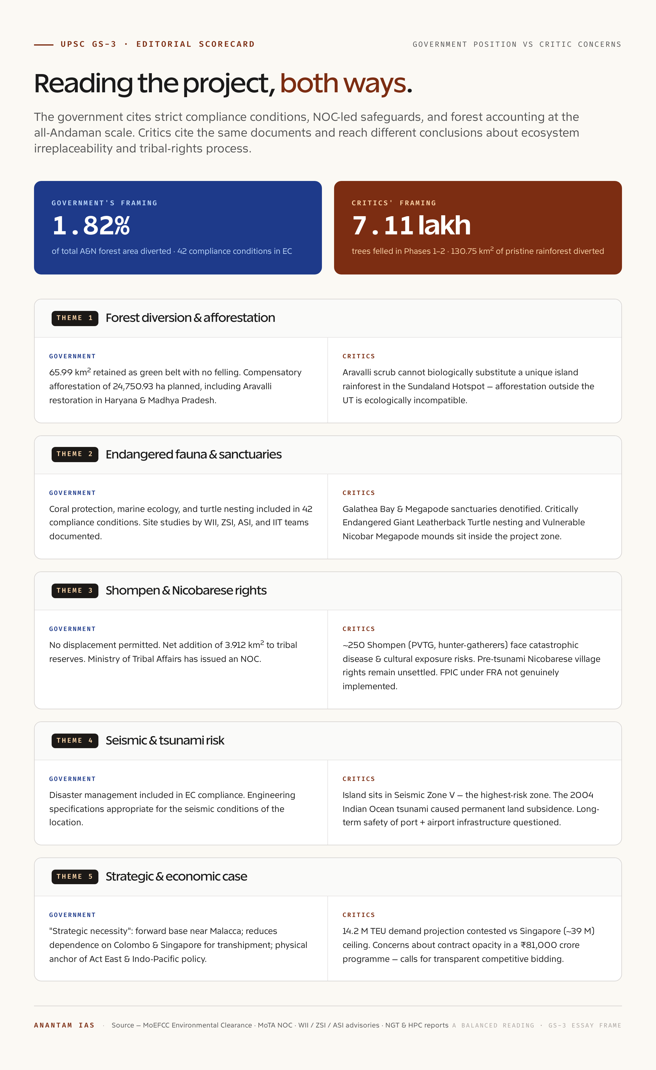
Government’s Position:
The government has maintained that the project embodies a balanced approach, integrating environmental safeguards with strategic and national development objectives.
Editorial note · the Shompen question
The Shompen are a Particularly Vulnerable Tribal Group of approximately 250 people in voluntary isolation. The Anthropological Survey of India and contemporary disease-exposure literature both warn that even brief contact with semi-urban populations can be catastrophic for groups without modern immunity. The government’s NOC and the proposed buffer zones are necessary safeguards; whether they are sufficient, given that the township alone projects a 6.5 lakh population on the same 910 sq km island, remains an open empirical question. Free, prior and informed consent under the Forest Rights Act is the standard the Supreme Court has repeatedly affirmed. Genuine implementation — not merely procedural sign-off — is the test.
Key official arguments include:
- Only ~1.82% of the total A&N Islands forest area is diverted, and 65.99 sq km will be retained as a green belt with no tree felling.
- Environmental clearance incorporates 42 strict compliance conditions covering biodiversity, coral protection, marine ecology, and disaster management.
- The Compensatory afforestation plan covers 24,750.93 ha across Haryana and Madhya Pradesh, including restoration of degraded Aravalli forests.
- No displacement of tribal populations will be permitted; a net addition of 3.912 sq km to tribal reserves is being effected.
- The Ministry of Tribal Affairs has issued a No-Objection Certificate; consultations with the Anthropological Survey of India, the Zoological Survey of India, the Wildlife Institute of India, and IITs were conducted.
Way Forward
- Dedicated exclusion zone around Shompen habitats with legally binding buffer regulations, overseen by a committee including anthropologists and tribal rights experts.
- Ecologically equivalent compensatory afforestation: CA in Haryana’s Aravallis cannot biologically substitute for a unique island rainforest. India should explore supplementary in-situ conservation, seed banking, and ex-situ preservation of endemic flora and fauna.
- Phased seismic and climate vulnerability audits before each construction phase, given the island’s Zone V status and documented tsunami-related subsidence in 2004.
- Transparent competitive bidding for port development contracts to address perceptions of crony capitalism and to ensure value for public funds in a ₹81,000-crore project.
- Settle pre-tsunami village rights of the Nicobarese community as a non-negotiable prerequisite before further development proceeds.
- Free, prior, and informed consent (FPIC) under the Forest Rights Act must be genuinely implemented.
The Great Nicobar Project requires balancing hard security imperatives with irreplaceable ecological and cultural heritage.
Editorial note · seismic accounting
The island is in Seismic Zone V — the highest-risk classification in BIS IS 1893. The 2004 Indian Ocean tsunami caused permanent land subsidence on parts of Great Nicobar, including near Indira Point. EC compliance conditions cover disaster management on paper; the harder question is the design return-period assumed in port and runway engineering, and whether evacuation plans for a projected 6.5 lakh population are credible on a single island with limited high ground. A staged seismic and climate vulnerability audit before each phase, as the article’s Way Forward proposes, is the prudent compromise between strategic urgency and engineering humility.
Editorial note · the transhipment economics
The 14.2 million TEU target is ambitious. Singapore, the regional benchmark, handles about 39 million TEUs after six decades of feeder-network density. Colombo (~7.7 M) and Port Klang (~13.7 M) sit between. Galathea would have to win cargo from incumbents and from Indian east-coast ports already pivoting to direct calls. The case is plausible — natural depth > 20 m without dredging is a real edge — but the demand projection deserves the same scrutiny applied to any infrastructure DPR. A balanced read is that Galathea materially raises India’s ceiling; whether it gets to 14.2 M TEU depends on shipping-line behaviour we do not control.
UPSC PYQ 2013
Q. Consider the following fauna of India:
1. Gharial
2. Leatherback turtle
3. Swamp deer
Which of the above is/are critically endangered?
(a) 1 and 2 only
(b) 3 only
(c) 1, 2 and 3
(d) None
Answer: (a)
Tell Google you want more of this.
Add Anantam IAS as a preferred sourceOne tap, and this site shows up more often in your own Top Stories, AI Overviews and AI Mode. Remove it any time.