Why in News?
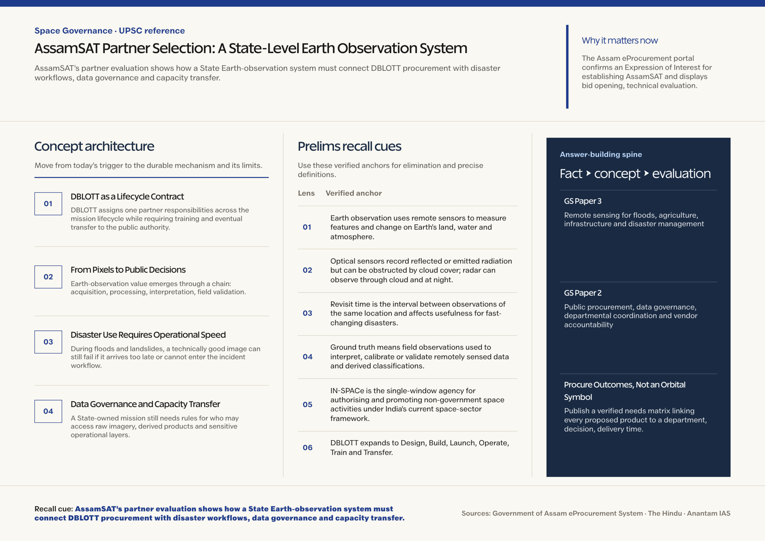
Assam said on August 23 that committees were evaluating proposals to select a private partner for AssamSAT, a proposed Earth-observation system under a DBLOTT procurement model.
- The Assam eProcurement portal confirms an Expression of Interest for establishing AssamSAT and displays bid opening, technical evaluation, financial evaluation and award stages.
- The State says proposals are in an advanced evaluation stage, but no partner has been selected in the verified public record reviewed for this note.
- No fixed launch date has been announced, and AssamSAT is not an operational satellite; present claims concern procurement and intended applications.
- The proposed model is DBLOTT: Design, Build, Launch, Operate, Train and Transfer, combining delivery with an eventual capability-transfer obligation.
- A dedicated system is valuable only if imagery becomes timely, validated decision products for departments rather than an isolated stream of satellite files.
- Assam’s recurring floods, riverbank change, agriculture and dispersed infrastructure create a strong use case for repeat observation joined with field and administrative data.
- A lifecycle contract can accelerate access to private expertise, but the State must retain control over public-purpose data, continuity, security and long-term institutional knowledge.
UPSC Relevance
Prelims Relevance
- Earth observation uses remote sensors to measure features and change on Earth’s land, water and atmosphere.
- Optical sensors record reflected or emitted radiation but can be obstructed by cloud cover; radar can observe through cloud and at night.
- Revisit time is the interval between observations of the same location and affects usefulness for fast-changing disasters.
- Ground truth means field observations used to interpret, calibrate or validate remotely sensed data and derived classifications.
- IN-SPACe is the single-window agency for authorising and promoting non-government space activities under India’s current space-sector framework.
- DBLOTT expands to Design, Build, Launch, Operate, Train and Transfer.
Mains Relevance
GS Paper 3
- Remote sensing for floods, agriculture, infrastructure and disaster management
- Private participation, mission assurance and State-level space capability
GS Paper 2
- Public procurement, data governance, departmental coordination and vendor accountability
Essay
- Technology becomes State capacity only when institutions can interpret, govern and act on it without permanent dependence on a vendor.
Background and Context
DBLOTT as a Lifecycle Contract
DBLOTT assigns one partner responsibilities across the mission lifecycle while requiring training and eventual transfer to the public authority.
- Design and build should translate departmental needs into sensor, orbit, ground-segment, processing and service requirements instead of procuring a satellite as a prestige object.
- Launch and operate place schedule, commissioning, health monitoring, data delivery and service continuity within a performance-managed arrangement.
- Train and transfer should leave Assam with qualified staff, documented procedures, usable ground systems and lawful access to software, data and mission knowledge.
- Evaluation must test technical feasibility, total lifecycle cost, launch and insurance risk, service levels, cybersecurity, exit terms and the credibility of capacity transfer.
From Pixels to Public Decisions
Earth-observation value emerges through a chain: acquisition, processing, interpretation, field validation, departmental decision and later evaluation.
- Agriculture departments can combine vegetation, moisture and land-use indicators with crop calendars and field reports to prioritise advisories, surveys and relief verification.
- Repeated imagery can track riverbank erosion, wetland change, forest disturbance and construction progress, but a spectral change does not explain its cause by itself.
- Infrastructure monitoring needs stable baselines, georeferenced project boundaries and clear thresholds for inspection; imagery should trigger verification rather than automatic punitive action.
- Product specifications should state resolution, revisit, latency, accuracy, cloud constraints and uncertainty so officials know which decisions each dataset can support.
Disaster Use Requires Operational Speed
During floods and landslides, a technically good image can still fail if it arrives too late or cannot enter the incident workflow.
- Before monsoon, baseline maps can identify exposed settlements, embankments, roads, shelters and critical facilities for contingency planning and resource positioning.
- During an event, rapid flood-extent products can support route planning and village prioritisation when combined with forecasts, gauges, local reports and rescue-team observations.
- Cloud cover can limit optical imagery during monsoon; procurement should plan complementary radar access, realistic acquisition windows and backup sources rather than promise uninterrupted visibility.
- After an event, change detection can guide damage surveys and recovery monitoring, but compensation decisions need transparent methods, field checks and an avenue to correct errors.
Data Governance and Capacity Transfer
A State-owned mission still needs rules for who may access raw imagery, derived products and sensitive operational layers.
- The contract should distinguish public datasets, restricted layers and commercially licensed inputs, with metadata, retention, audit logs and lawful sharing terms for each.
- Cybersecurity must cover spacecraft commands, ground stations, cloud processing, user credentials and supply-chain access because compromise can affect both data integrity and mission control.
- Training should be role-based for engineers, GIS analysts, disaster managers and departmental users, followed by supervised operations and measurable competency before transfer.
- Open interfaces, documented algorithms and portable archives reduce vendor lock-in and let Assam combine AssamSAT products with ISRO, international and field datasets.
Way Forward
Procure Outcomes, Not an Orbital Symbol
- Publish a verified needs matrix linking every proposed product to a department, decision, delivery time, validation method and accountable user.
- Use milestone payments and acceptance tests for design, launch, commissioning, data quality, service availability, training and transfer rather than hardware delivery alone.
- Create an independent governance board for data access, security, algorithm review, interdepartmental standards and public-interest release of low-risk products.
- Run flood and agriculture pilots using existing imagery before launch so workflows, staff and ground validation mature even if the mission schedule changes.
Conclusion
- AssamSAT is presently a procurement-stage proposal, so success should be judged by partner selection quality and institutional readiness, not an assumed launch or operating capability.
- A strong Mains answer should connect DBLOTT accountability with rapid disaster products, governed data access and a verified transfer of skills that survives the original vendor contract.
UPSC Practice Questions
Prelims MCQ 1
With reference to Earth-observation systems, consider the following statements:
- Optical satellite observations can be obstructed by cloud cover.
- Radar observation can operate through cloud and during night.
- Ground truth is used to validate interpretations derived from remotely sensed data.
How many of the above statements are correct?
(a) Only one (b) Only two (c) All three (d) None
Answer: (c) All three
Explanation:
All three are correct. Sensor choice and ground validation are especially important for operational flood mapping during cloudy monsoon conditions.
Prelims MCQ 2
In the AssamSAT procurement context, what does DBLOTT stand for?
(a) Design, Build, Launch, Operate, Train and Transfer (b) Develop, Borrow, Lease, Observe, Track and Test (c) Design, Bid, License, Orbit, Track and Terminate (d) Deploy, Build, Locate, Operate, Test and Transfer
Answer: (a) Design, Build, Launch, Operate, Train and Transfer
Explanation:
The model combines end-to-end mission delivery and initial operation with training and eventual transfer of capability to the procuring authority.
UPSC Mains Questions
- How can a DBLOTT procurement model build lasting State capacity rather than long-term vendor dependence in an Earth-observation mission?
- A satellite image is not a disaster-management decision. Explain the institutional chain required to convert Earth-observation data into timely flood response.
Sources: Government of Assam eProcurement System and The Hindu.
Frequently Asked Questions
Has Assam selected the AssamSAT partner?
No selection was visible in the verified public record reviewed for this note. The State reported that committees were evaluating private-sector proposals.
Is AssamSAT already operational?
No. AssamSAT remains a proposed system in procurement evaluation. No operational satellite or fixed launch date has been established by the verified sources.
What is the main benefit of DBLOTT?
It can combine end-to-end delivery with training and transfer, provided the contract defines performance, knowledge transfer, data rights, exit conditions and measurable public capacity.
How can Earth observation support flood management?
It can provide baseline exposure maps, rapid flood extent and post-event change products when combined with forecasts, gauges, field reports and timely emergency workflows.
Why does AssamSAT need a data-governance policy?
Earth-observation products may combine public, commercial and sensitive layers. Governance defines access, sharing, retention, security, auditability and correction of consequential derived decisions.
Tell Google you want more of this.
Add Anantam IAS as a preferred sourceOne tap, and this site shows up more often in your own Top Stories, AI Overviews and AI Mode. Remove it any time.