Why in News?
On 12 October 2026, IMD launched its Cyclone Warning and Marine Weather Services Decision Support System to bring cyclone forecasts and hazard information together.
- The WebGIS platform presents cyclone tracks, intensity, winds, rainfall, storm surge and rainfall forecasts for river catchments through interactive maps.
- Demonstrations showed the cone of uncertainty alongside district rainfall warnings, with additional views displaying wind distribution and storm surge warnings.
- The launch accompanied the pre-cyclone exercise for the post-monsoon season; disaster authorities, technical agencies and other operational users participated.
- The system is publicly accessible through IMD and RSMC New Delhi websites. The announcement does not report measured disaster-loss reductions attributable to it.
- A cyclone track answers where the storm centre may move; it cannot alone show every place exposed to damaging weather.
- Combining hazard layers helps users consider different threats together, but local response still depends on exposure, vulnerability and practical options.
UPSC Relevance
Prelims Relevance
- India Meteorological Department
- WebGIS and decision support
- Cone of uncertainty
- Storm surge versus rainfall flooding
- River catchment rainfall forecasts
Mains Relevance
GS Paper 3
- Interpreting cyclone forecasts for multi-hazard preparedness
- Connecting scientific warnings with protective action
GS Paper 2
- Coordination between technical agencies and local disaster authorities
Essay
- Acting responsibly under uncertainty requires both scientific information and capable public institutions.
Background and Context
What an Integrated Cyclone Map Adds
The system places related forecasts in one geographic view, helping users compare hazards that require different decisions before a cyclone reaches the coast.
- A decision support system organizes information for users assessing a developing situation. IMD’s platform combines cyclone and marine weather products; the announcement does not describe an automatic evacuation authority or a replacement for local administration.
- Observed tracks describe where the cyclone has been, while forecast tracks describe its expected movement. Reading them separately avoids treating a projected location as something already measured or a future path as a certainty.
- The platform displays intensity and wind distribution alongside the track. Their separate presentation matters: knowing the centre’s projected location does not, by itself, identify the spatial extent of potentially damaging winds around the storm.
- District rainfall warnings and catchment rainfall forecasts provide different spatial perspectives. One supports area-based communication; the other helps users consider rain falling across the land draining toward a river, beyond an individual coastal location.
- Like weather observations and early warning, a shared map supports interpretation. Its practical value should be assessed through the decisions it improves, rather than simply the number of layers displayed on screen.

Why the Cone Is Not a Safety Boundary
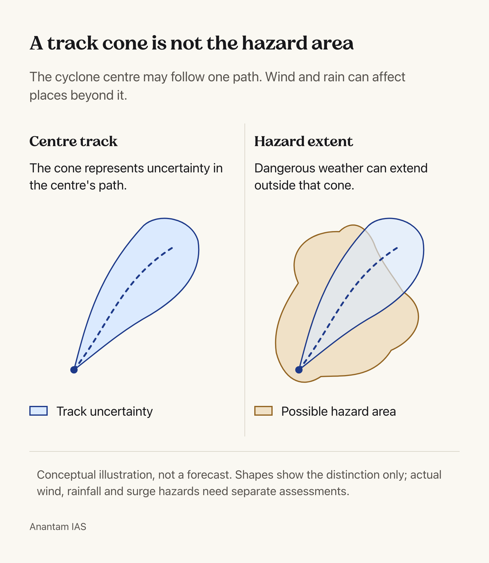
Track uncertainty and hazard extent describe different things; confusing them can make a place outside the cone appear safer than the warning evidence supports.
- The cone of uncertainty concerns the possible path of the cyclone’s centre. It is not an outline of the storm itself, nor a map containing every location that could experience damaging weather during its passage.
- Official track-cone guidance distinguishes centre-track uncertainty from the storm’s size. Wind and rainfall hazards can extend beyond that track envelope, so being outside it does not establish that a settlement faces no threat.
- Storm surge involves cyclone-driven seawater affecting the coast. It differs from flooding caused by heavy rainfall; a warning assessment should identify the water source instead of treating every flooded location as a surge impact.
- WMO identifies torrential rainfall as a cause of flooding and possible landslides. This explains why preparedness cannot end with the expected coastal crossing point: inland communities may also face substantial hazards from the same cyclone.
- Read track, wind, rainfall and surge products together for the location concerned. A plausible centre path is only part of the assessment; each hazard layer supplies information that the centre line cannot communicate by itself.
How Forecasts Should Inform Local Decisions
The following are preparedness principles, not newly announced operating rules or evidence that every district has already implemented an effective response plan.
- Combine hazard information with knowledge of exposed settlements, infrastructure and people needing assistance. A forecast of dangerous weather becomes useful for action when authorities understand what lies in its potential path and who needs support.
- Check the forecast’s issue time before interpreting a saved map or forwarded screenshot. Decisions should use current official updates, because an earlier picture may no longer represent the assessment available to the responsible warning agencies.
- Assess overlapping hazards when choosing routes and shelters. For example, a proposed response should account for both coastal flooding and heavy rain, rather than assuming a location suitable for one threat is suitable for all.
- The lesson from dam emergency action plans is relevant: technical information needs an operational handoff. Authorities should connect the forecast with clear public instructions, responsible recipients and arrangements for people who cannot move independently.
- Judge the system through usable warning and response: whether relevant users understand the forecast and can act in time. A successful launch demonstrates availability, while claims of improved outcomes require evidence from subsequent operational use.
Way Forward
Rehearse Decisions Using All Relevant Hazards
- Use scenario exercises that change track, rainfall and surge assumptions; check whether local plans adapt without treating the cone as an evacuation boundary.
- Make public instructions specific about affected locations, required action and reliable updates; test whether recipients understand them before severe weather disrupts communication.
- Review warning-to-action delays after exercises and events, assigning corrections to named agencies instead of treating platform access alone as preparedness.
Conclusion
- Integrated cyclone warnings are useful when users distinguish the probable centre track from the wider distribution of hazards and connect both with local exposure and vulnerability.
- The strongest disaster-management argument links forecast interpretation, multi-hazard planning and protective action. A new information platform supports that chain, but its launch alone cannot establish that disaster losses have fallen.
UPSC Practice Questions
Prelims MCQ 1
With reference to cyclone forecast interpretation, consider the following statements:
- A track cone concerns uncertainty in the cyclone centre’s path.
- Damaging weather can occur outside the track cone.
- The track cone alone defines the full extent of storm surge flooding.
How many of the above statements are correct?
(a) Only one (b) Only two (c) All three (d) None
Answer: (b) Only two
Explanation:
The first two statements are correct. Track uncertainty and hazard extent differ; storm surge requires its own hazard information.
Prelims MCQ 2
Which approach best uses an integrated cyclone decision support system?
(a) Treat the forecast centre line as the complete hazard zone (b) Assume every district outside the cone is safe (c) Combine relevant hazard layers with local exposure and response arrangements (d) Treat a map display as an automatic evacuation order
Answer: (c) Combine relevant hazard layers with local exposure and response arrangements
Explanation:
Integrated forecasts support decisions when interpreted with local conditions and response capacity. Neither the centre line nor the cone represents every hazard.
UPSC Mains Questions
- Explain why a cyclone track forecast cannot substitute for multi-hazard preparedness. Illustrate with wind, rainfall and storm surge.
- How can decision support systems improve cyclone preparedness? Discuss the institutional steps needed to translate forecast information into protective action.
Sources: PIB, Ministry of Earth Sciences and World Meteorological Organization.
Frequently Asked Questions
What did IMD launch on 12 October 2026?
IMD launched a WebGIS-based Cyclone Warning and Marine Weather Services Decision Support System. It brings cyclone tracks, intensity, winds, rainfall, storm surge and catchment rainfall forecasts into an interactive platform.
Does being outside the cyclone cone mean a place is safe?
No. The cone concerns uncertainty in the cyclone centre’s track, rather than the full storm or all its hazards. Users must also consult relevant wind, rainfall and storm surge warnings.
How does storm surge differ from rainfall flooding?
Storm surge concerns cyclone-driven seawater affecting coastal areas. Rainfall flooding results from rain and the resulting accumulation or movement of water. Both hazards can matter during the same cyclone.
Does the decision support system automatically order evacuation?
The announcement describes a platform that supports informed decisions. It does not establish automatic evacuation orders. Protective action still requires responsible authorities to interpret warnings alongside local exposure and response arrangements.
Tell Google you want more of this.
Add Anantam IAS as a preferred sourceOne tap, and this site shows up more often in your own Top Stories, AI Overviews and AI Mode. Remove it any time.