A roll cloud is one of the more visually striking phenomena in the lower atmosphere. Imagine a single white tube of cloud, sometimes hundreds of kilometres long, rolling smoothly across a clear sky as if extruded from a giant pipe. The cloud rotates about its own horizontal axis as it moves, the leading edge climbing while the trailing edge sinks, and the entire structure stays detached from any other cloud system. It is not the leading edge of a thunderstorm. It is not connected to a cumulonimbus base. It is its own thing.
For UPSC, the roll cloud became a frequent prelims and current-affairs prompt after a 2024-25 surge in documented roll cloud sightings off the Indian coast and after the publication of new physics in Nature Scientific Reports. The cloud also features in geography questions on cloud classification (under the Arcus type), in disaster management questions on gust fronts and squall lines, and in current-affairs questions on the Morning Glory of Australia, which is the most famous regularly-occurring roll cloud in the world.
This guide covers the basic physics of roll cloud formation, the difference between roll clouds and shelf clouds (the other major Arcus type), the global locations where roll clouds recur, the Indian occurrences, and the meteorological context that makes the phenomenon possible.
Quick Facts
- Cloud type: Arcus cloud, sub-type roll cloud (the other Arcus is the shelf cloud)
- Form: Low-level, horizontal, tube-shaped, often hundreds of kilometres long
- Detachment: Not attached to any parent cloud or storm front (this is what separates a roll from a shelf)
- Rotation: Rotates about its own horizontal axis, leading edge climbs, trailing edge sinks
- Altitude: Typically 100 to 2,000 metres above ground
- Length: From tens to over 1,000 kilometres in extreme cases
- Width: 1 to 2 kilometres in cross-section
- Most famous occurrence: Gulf of Carpentaria, northern Australia, where a recurring autumn (September-November) roll cloud is locally called the Morning Glory
- Formation drivers: Solitary waves in a stable atmospheric layer, gust fronts from thunderstorm outflow, sea-breeze convergence
- Wind shear requirement: Strong horizontal wind shear at the cloud’s altitude is needed for the rotation
- Indian sightings: Reported off Tamil Nadu (Tiruvannamalai 2022), Maharashtra coast, Kerala backwaters, and parts of the Eastern Ghats during 2024-25
- Recent research: A 2025 paper in Nature Scientific Reports proposed an updated solitary-wave physics model
What Is a Roll Cloud
A roll cloud is a horizontal, tubular cloud that looks like a long white pipe lying across the sky. The defining features are the tube shape, the horizontal axis of rotation, and the absence of any vertical attachment to a storm cell or front. A roll cloud appears to roll across the sky because the leading edge is rising due to upward air motion while the trailing edge is sinking due to downward air motion. The rolling motion is real, not just an optical effect.
Roll clouds are classified under the Arcus genus, which is a supplementary feature in the World Meteorological Organisation’s cloud atlas. The Arcus genus has two species: roll cloud (detached, free-floating) and shelf cloud (attached to a parent thunderstorm). The visual difference is straightforward in the field. A shelf cloud sits below the cumulonimbus base of an advancing thunderstorm and is part of the same air-mass complex. A roll cloud sits in clear or lightly clouded sky with no parent structure visible.
The internal structure of a roll cloud is a horizontal cylinder of rotating air. Warm, moist air is drawn up at the leading edge, condensation forms the visible cloud, and the air sinks at the trailing edge before re-entering the system. This is a closed circulation, which is why a roll cloud can travel for hundreds of kilometres without dissipating, provided the supporting atmospheric conditions persist.
Background and Historical Context
Roll clouds have been observed for centuries by mariners, pilots, and coastal residents, but they were poorly understood until the late 20th century. The Morning Glory of the Gulf of Carpentaria began attracting scientific attention in the 1970s, when Australian researchers documented the recurring autumn appearance of a long, tubular cloud over the small town of Burketown. By the 1980s, glider pilots began travelling to Burketown specifically to ride the standing wave under the Morning Glory, which can lift a glider at climb rates of several metres per second and propagate for over 1,000 kilometres without dissipating.
The physics of roll clouds was clarified through the 1980s and 1990s with field campaigns in northern Australia, instrumented aircraft flights, and numerical modelling. The dominant explanation became the solitary wave hypothesis, in which a single wave packet travels through a stable atmospheric layer without dissipating, lifting moist air at its leading edge and producing the visible cloud. A 2025 paper in Nature Scientific Reports refined the model with new measurements from a Morning Glory campaign.
How Roll Clouds Form
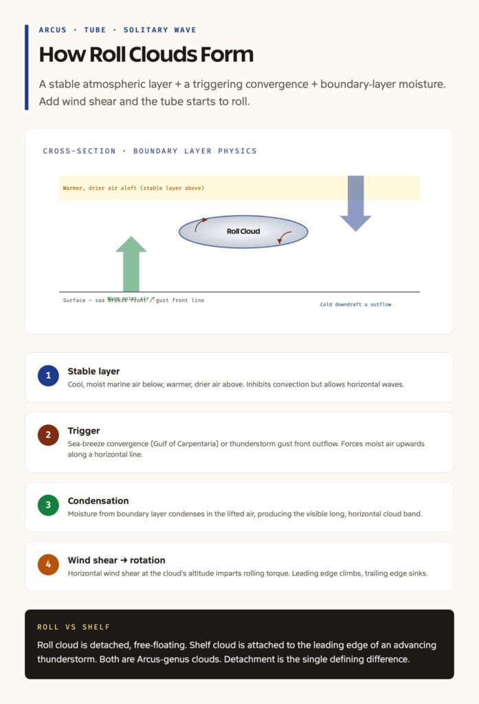
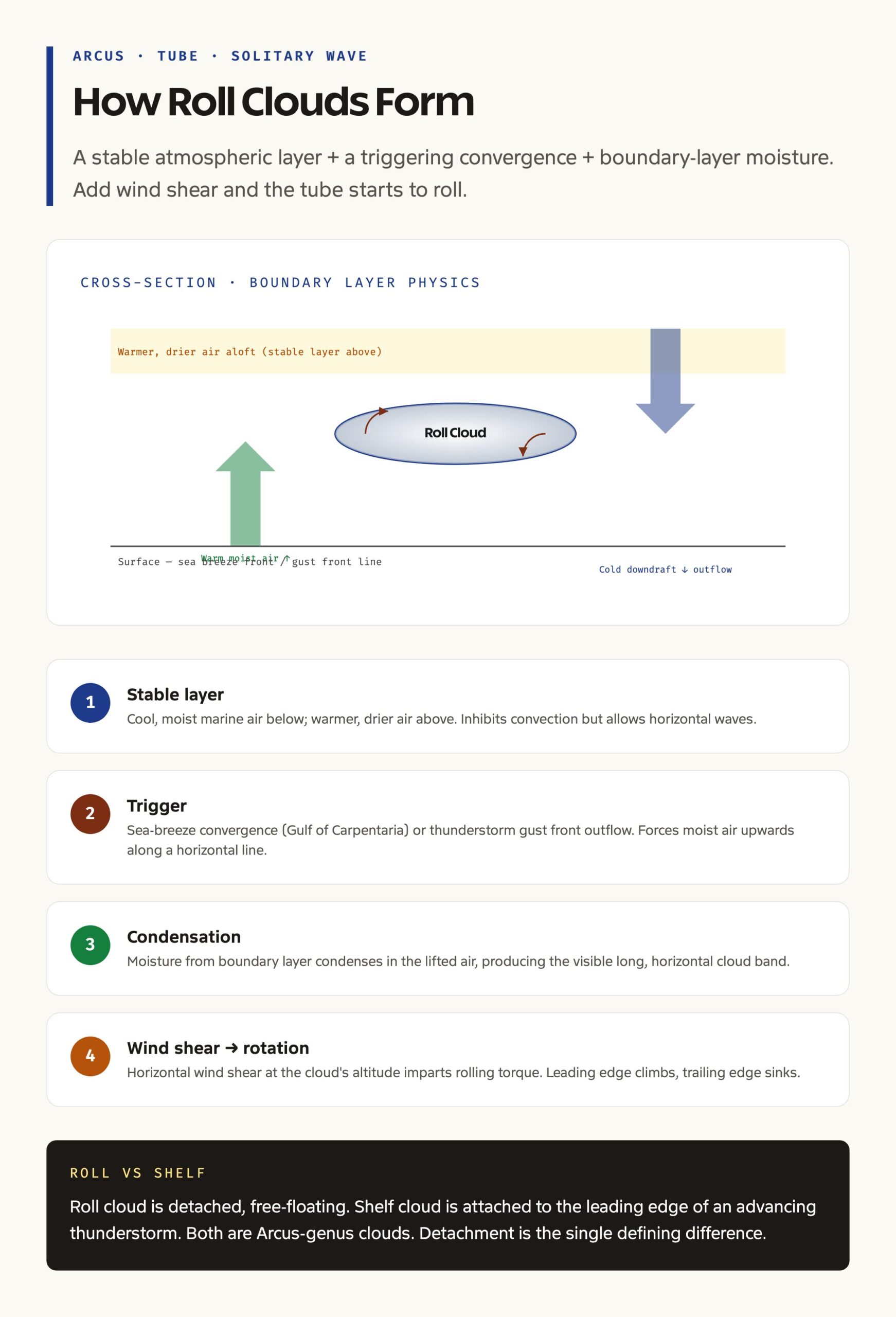
The formation of a roll cloud requires three ingredients in the lower atmosphere: a stable layer to host the wave, a triggering mechanism, and sufficient moisture for visible condensation.
The stable layer is typically the boundary between a cool, moist marine air mass below and a warmer, drier air mass above. The vertical temperature gradient inhibits free convection but allows horizontal waves to propagate without breaking. This is the same physical setup that produces lee waves in mountain meteorology.
The trigger varies by location. In the Gulf of Carpentaria, the trigger is the convergence of sea breezes from the Cape York Peninsula and the Arnhem Land coast, which collide overnight and launch a solitary wave that travels southwards through the morning. In thunderstorm-related cases, the trigger is the gust front of a decaying thunderstorm: the cool downdraft outflow surges outwards along the surface and forces the warmer ambient air upwards, which creates a horizontal lifting line. If the thunderstorm dissipates while the gust front continues to propagate, the resulting cloud becomes detached and is reclassified as a roll cloud rather than a shelf cloud.
The moisture requirement is satisfied by the boundary-layer humidity, which is typically high over coastal and inland water bodies. Without sufficient moisture, the lifting wave produces no visible cloud, and the phenomenon goes unobserved.
The rotation is driven by horizontal wind shear at the altitude of the cloud. If the wind speed and direction change with height around the wave’s level, the resulting torque on the rising and sinking air produces the rolling motion. Without wind shear, the wave would simply lift moist air without imparting rotation, producing a less distinct cloud band.
Roll Cloud vs Shelf Cloud

The single most testable distinction in cloud-related questions is between roll cloud (detached, Arcus, free-floating) and shelf cloud (attached, Arcus, parent thunderstorm).
A shelf cloud sits at the leading edge of an advancing thunderstorm, attached to and continuous with the cumulonimbus base. It often appears as a dark, layered, wedge-shaped cloud that descends towards the ground and sweeps outward as the storm advances. The shelf cloud is the visible expression of the gust front lifting warm air ahead of the storm. Wherever there is a shelf cloud, there is an active thunderstorm immediately behind it.
A roll cloud is the same structure that has detached from its parent storm or formed independently from a non-storm trigger. The roll cloud floats free in the sky, with no thunderstorm visible behind it, and its rolling motion is more pronounced because it is not constrained by the parent storm. Roll clouds are rarer and more striking than shelf clouds.
Global Locations
The Morning Glory of the Gulf of Carpentaria is the most famous and most predictable roll cloud in the world. It occurs almost daily during the late dry season (September to November) over a corridor running from the Cape York Peninsula southwards across the Gulf to Burketown and Borroloola. The Morning Glory can be a single tube up to 1,000 kilometres long, or a series of three to ten parallel tubes spaced 30 to 50 kilometres apart.
Beyond the Gulf of Carpentaria, roll clouds have been documented along several recurring corridors. The English Channel produces roll clouds during summer when sea breeze convergence over the Channel collides with continental air masses. The Berlin region of central Europe occasionally sees roll clouds linked to summer thunderstorm gust fronts. Coastal Brazil and the Gulf of Mexico produce thunderstorm-derived roll clouds during the wet season. The Russian steppe has produced documented roll cloud sightings linked to sea-breeze interactions over the Caspian.
In all these locations, the common thread is a stable boundary layer, a regular triggering mechanism, and adequate boundary-layer moisture.
Indian Occurrences
India has not historically been a major roll cloud location, but documented sightings have increased through the 2020s. A widely shared roll cloud was photographed over Tiruvannamalai in Tamil Nadu in October 2022, with a clearly tubular structure stretching across the horizon. Maharashtra’s Konkan coast produced a documented roll cloud in 2024, with the cloud running parallel to the coastline and visible from Mumbai’s western suburbs. Kerala’s backwater region and parts of the Eastern Ghats have produced occasional sightings, often linked to the receding southwest monsoon and the onset of the northeast monsoon.
The increase in documented Indian sightings is partly a function of better camera coverage (smartphones plus social media) and partly a function of changing weather patterns. The southwest-to-northeast monsoon transition produces the kind of stable boundary layer and sea-breeze convergence that supports roll cloud formation, and the warming of the Indian Ocean is altering the temperature gradient between marine and continental air masses in ways that may favour more frequent roll cloud events. Rigorous meteorological documentation of Indian roll clouds is still limited, but the IMD has begun cataloguing sightings reported through the Mausam app.
Meteorological and Aviation Significance

A roll cloud is more than a meteorological curiosity. It carries significant operational implications.
For aviation, a roll cloud marks a region of intense vertical wind shear and strong updraft-downdraft transitions. Pilots flying through or near a roll cloud can encounter sudden lift of several metres per second followed by equivalent downdraft, which is hazardous for low-altitude operations. Glider pilots, by contrast, deliberately fly along the leading edge to ride the standing wave for extended distances at high speed.
For surface weather, a roll cloud often signals an incoming temperature drop and a sustained wind shift. The Morning Glory passage in northern Australia drops surface temperatures by several degrees within minutes and shifts winds from north-east to south-west or south-east, with the shift lasting several hours.
For climate research, roll clouds are a useful indicator of boundary-layer dynamics. Long-term monitoring of roll cloud occurrence, particularly in regions with regular phenomena like the Morning Glory, contributes to validating numerical models of stable layer dynamics and convergence-driven wave generation.
Mains Hooks
For UPSC mains, the roll cloud is a small but useful example for answers on cloud classification, atmospheric stability, and the interaction between local circulations and synoptic-scale weather. A useful framing is that roll clouds illustrate how mesoscale phenomena (sea breeze convergence, gust fronts) can produce coherent, long-lived atmospheric structures that propagate well beyond their formation zone, which is important for understanding both severe weather forecasting and the limits of conventional numerical weather prediction.
Frequently Asked Questions
What is a roll cloud?
A roll cloud is a low-level, horizontal, tube-shaped Arcus cloud that rotates about its horizontal axis as it moves. It is detached from any parent thunderstorm or front, which separates it from the related shelf cloud. Roll clouds form in stable atmospheric layers under the action of solitary waves, gust fronts, or sea-breeze convergence.
What is the Morning Glory cloud?
The Morning Glory is the most famous regularly-occurring roll cloud in the world. It appears almost daily over the Gulf of Carpentaria in northern Australia during the late dry season (September to November), often as a single tube up to 1,000 kilometres long, sometimes as a series of parallel tubes. The phenomenon is generated by the overnight collision of sea breezes from the Cape York Peninsula and Arnhem Land.
What is the difference between a roll cloud and a shelf cloud?
A shelf cloud is attached to and continuous with the base of an advancing thunderstorm, while a roll cloud is detached and free-floating with no parent storm. Both belong to the Arcus cloud genus. The detachment is the single defining difference.
Has a roll cloud been seen in India?
Yes. Documented sightings include Tiruvannamalai in Tamil Nadu in October 2022, the Maharashtra Konkan coast in 2024, Kerala’s backwater region, and parts of the Eastern Ghats. The increase in Indian sightings through the 2020s is partly due to better camera coverage and partly due to changing monsoon transition patterns.
Why is the rotation of a roll cloud important?
The rotation requires strong horizontal wind shear at the cloud’s altitude and is the visible indicator of intense updraft-downdraft transitions. The rotating circulation is hazardous for low-altitude aviation, marks a sharp surface temperature drop and wind shift on passage, and provides the standing-wave lift that glider pilots can ride for hundreds of kilometres.
Tell Google you want more of this.
Add Anantam IAS as a preferred sourceOne tap, and this site shows up more often in your own Top Stories, AI Overviews and AI Mode. Remove it any time.