

Disclosure: this guide contains Amazon affiliate links. As an Amazon Associate, Anantam IAS earns from qualifying purchases — at no extra cost to you.
The Barak River is the principal river of southern Assam and one of the two major river systems of the Indian Northeast — the other being the Brahmaputra. Rising in the hills of Manipur, flowing through Nagaland, Mizoram, Assam, and finally Bangladesh (where it merges into the Meghna), the Barak drains the Barak-Surma-Meghna basin, which covers roughly 83,000 sq km across India and Bangladesh.
Although smaller and less famous than the Brahmaputra, the Barak is critical to the Barak Valley of Assam (Cachar, Karimganj, Hailakandi districts), to inland water transport under NW-6, and to India's Act East and sub-regional connectivity with Bangladesh and Myanmar.
Physical Profile
| Feature | Detail |
|---|---|
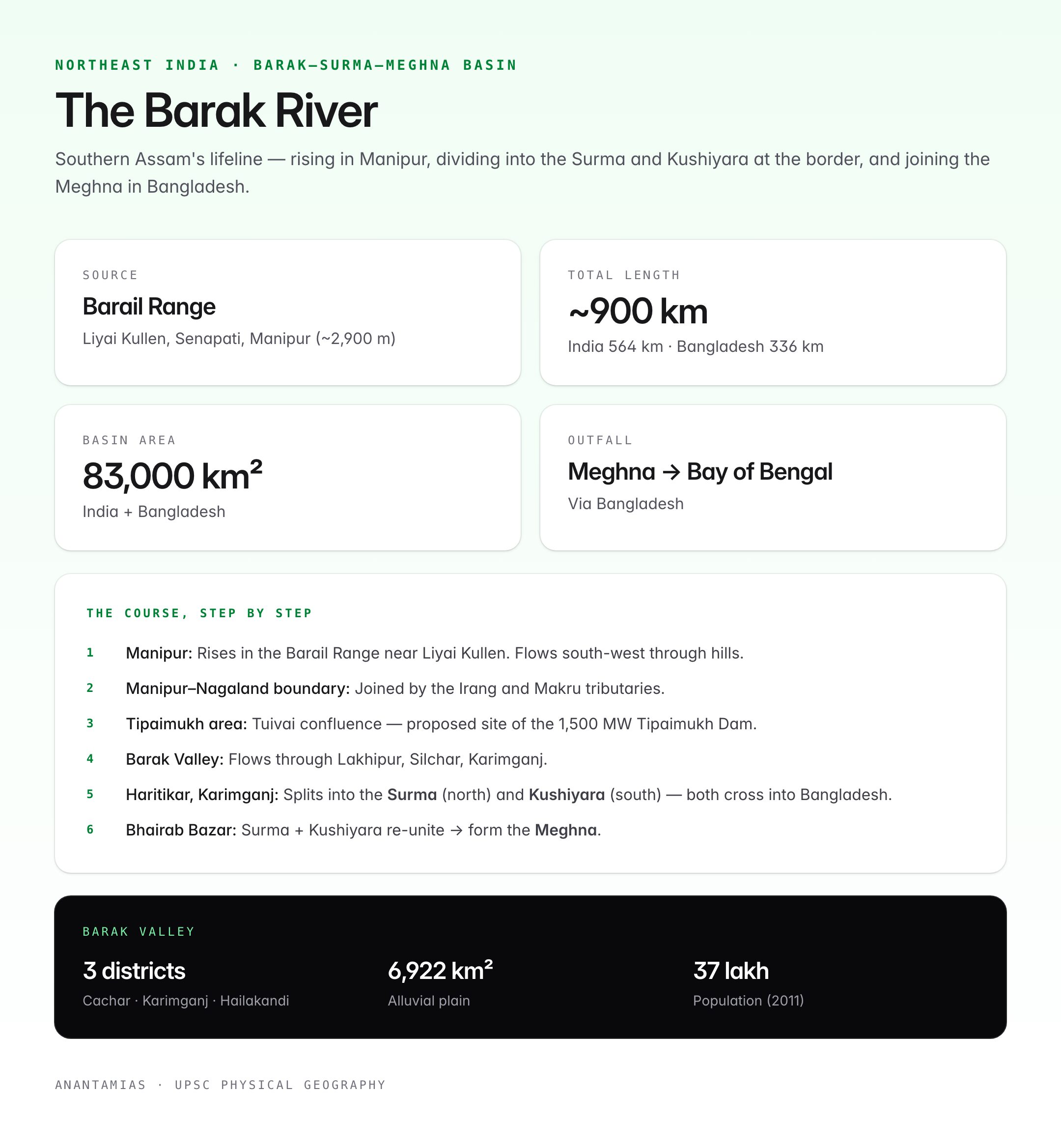
| Source | Japvo / Liyai Kullen area of the Barail Range, Senapati district, Manipur (~2,900 m) |
| Total length | ~900 km (India: ~564 km; Bangladesh: ~336 km, as Surma and Kushiyara, ending in Meghna) |
| States (India) | Manipur → Nagaland → Assam → Mizoram (tributaries) |
| Countries | India → Bangladesh → Bay of Bengal (via Meghna) |
| Basin area | ~83,000 sq km (India + Bangladesh) |
| Discharge | Monsoon-dominated; annual average ~20,000 cumecs at Amalshid |
| Highest flood record | Severe floods in 1986, 1991, 2004, 2018, 2022 |
Course of the Barak

Oxford Student Atlas for India — 7th Edition
- 160 pages, Oxford University Press, the current edition
- India-focused thematic maps: physical, political, rivers, climate, soils, vegetation, plus world maps
- Made for UPSC and state PSC map work; slim enough to stay open beside the textbook
- Source — Manipur: Rises in the Barail Range near Liyai Kullen village, Senapati district. Flows south-west through steep hill terrain.
- Manipur–Nagaland boundary: Forms part of the boundary with Nagaland; joined by the Irang and Makru tributaries.
- Manipur–Assam boundary: Cuts across the Jiri and Tipaimukh area; Tipaimukh Dam project is proposed at the confluence with the Tuivai.
- Assam — Barak Valley: Flows through Lakhipur, Silchar, Karimganj. At Haritikar in Karimganj, the river splits into two distributaries — the Surma (flows north) and the Kushiyara (flows south) — both crossing into Bangladesh.
- Bangladesh: Surma and Kushiyara re-unite near Bhairab Bazar to form the Meghna, which joins the combined Ganga-Brahmaputra before entering the Bay of Bengal.
Major Tributaries
Left-bank tributaries
| Tributary | Origin | Notes |
|---|---|---|
| Jiri | Nagaland | Meets Barak at Jirighat |
| Chiri | Jaintia Hills, Meghalaya | Joins in Cachar |
| Madhura | Cachar hills | |
| Longai | Mizoram | Important in Karimganj |
| Sonai | Mizoram | Joins below Silchar |
Right-bank tributaries
| Tributary | Origin | Notes |
|---|---|---|
| Tuivai | Mizoram / Manipur | Largest right-bank tributary; proposed Tipaimukh Dam site |
| Tuirial / Sonai | Mizoram | |
| Katakhal | Cachar–Hailakandi | |
| Dhaleswari / Tlawng | Mizoram |
Barak Valley
The Barak Valley is the alluvial plain formed by the river in southern Assam, comprising Cachar, Karimganj, and Hailakandi districts (part of the old Surma Valley).
| Feature | Detail |
|---|---|
| Area | ~6,922 sq km |
| Population | ~37 lakh (2011 Census) |
| Languages | Bengali (Sylheti dialect) majority, with Dimasa, Manipuri, Hindi, and tribal languages |
| Economy | Rice, tea, areca nut, bamboo, jute, fisheries |
| Administrative hub | Silchar |
| Transport gateway | Silchar Railway Station and Silchar Airport |
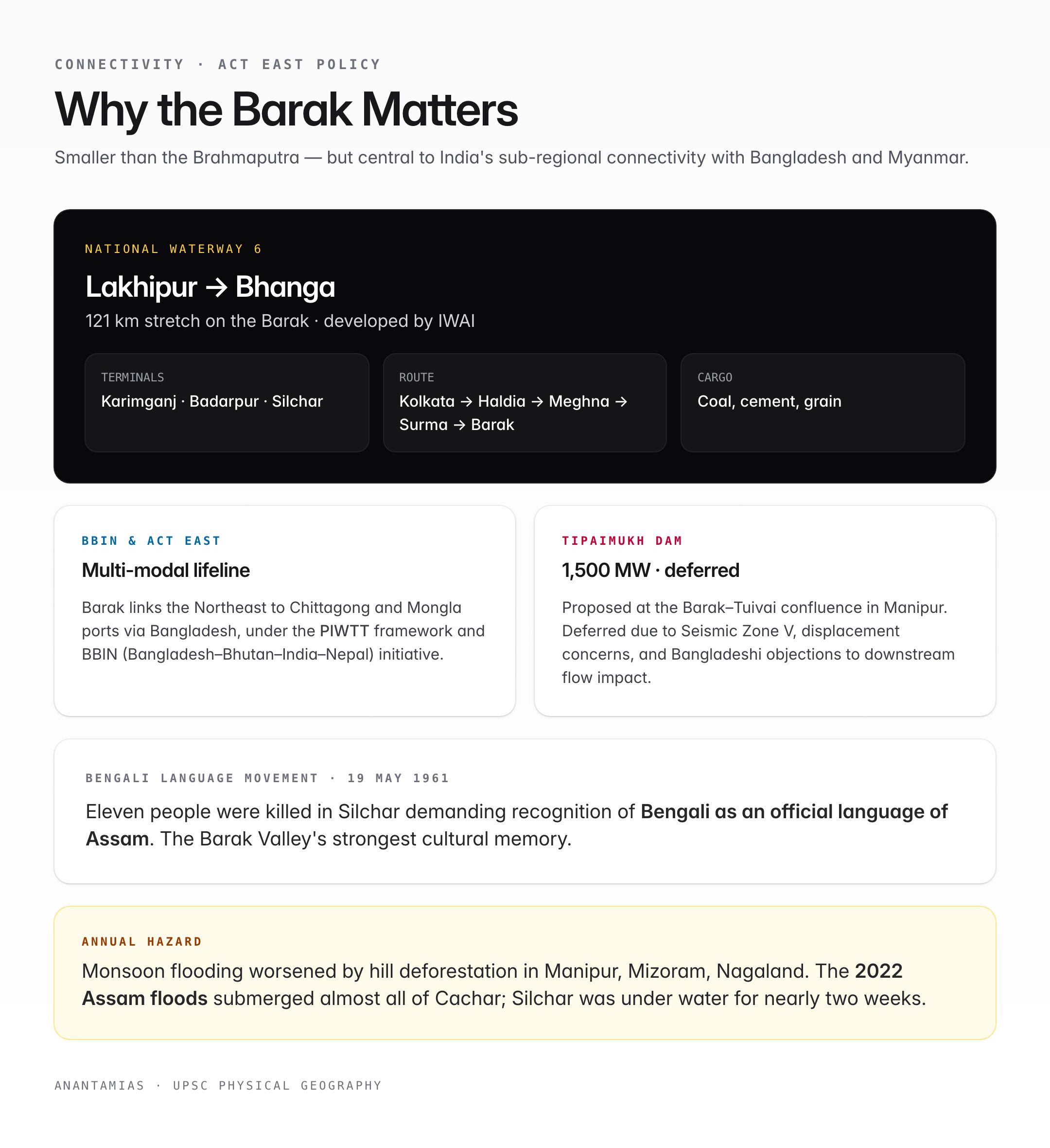
Historically linked to the Sylhet region (now in Bangladesh), the Barak Valley has a strong Bengali cultural identity and is remembered for the Bengali Language Movement of 19 May 1961, when 11 people died in Silchar demanding recognition of Bengali as an official language of Assam.
Inland Waterways: National Waterway 6
- National Waterway 6 (NW-6) — declared under the National Waterways Act, 2016 — covers the Barak River from Lakhipur to Bhanga (Karimganj), a stretch of 121 km.
- Inland Waterways Authority of India (IWAI) is developing terminals at Karimganj, Badarpur, and Silchar.
- The Barak connects to the Indo-Bangladesh Protocol on Inland Water Transit and Trade (PIWTT) — cargo from Kolkata / Haldia can reach Silchar via the Meghna-Surma-Barak route.
- Supports freight movement in coal, cement, food grains, and construction materials to the Northeast.
Strategic and Geopolitical Importance
- Sub-regional connectivity: Under the BBIN (Bangladesh-Bhutan-India-Nepal) initiative and the Act East Policy, the Barak is part of the multi-modal network linking the Northeast to the Chittagong and Mongla ports via Bangladesh.
- Kaladan Multi-Modal Transit Transport Project, while primarily via Mizoram's Kaladan River to Myanmar's Sittwe port, complements Barak-route logistics.
- Tipaimukh Dam project — a proposed 1,500 MW hydel + flood-control dam at the Barak-Tuivai confluence in Manipur. Deferred due to environmental concerns, seismic risk (Zone V), and Bangladeshi objections to downstream flow impact.
- The Agartala–Akhaura rail link (2023), though not on the Barak, rides on the same sub-regional logic: shortening routes into Bangladesh.
Floods and Hazards
- The Barak Valley sees annual monsoon flooding, worsened by deforestation in the hills of Manipur, Mizoram, and Nagaland.
- The 2022 Assam floods inundated almost all of Cachar district; Silchar was under water for nearly two weeks.
- Embankment failures are frequent — the valley lies in Seismic Zone V.
- River-bank erosion displaces hundreds of households each year in Karimganj.
Ecology and Biodiversity
- The Barak basin is part of the Indo-Burma biodiversity hotspot.
- Hoollongapar Gibbon Sanctuary (Jorhat) and Barak Bhuban Hills host endangered primates.
- Fish diversity: rohu, catla, hilsa (in lower reaches), pabda, magur, chital — hilsa migration is blocked above Bangladesh's barrages.
- The Shon Beel / Son Beel — one of Assam's largest wetlands — lies in Karimganj and is a Ramsar-proposed site.
- Tropical rainforests of Cachar and Hailakandi are home to clouded leopards, hoolock gibbons, and elephants.
Comparison: Brahmaputra vs Barak
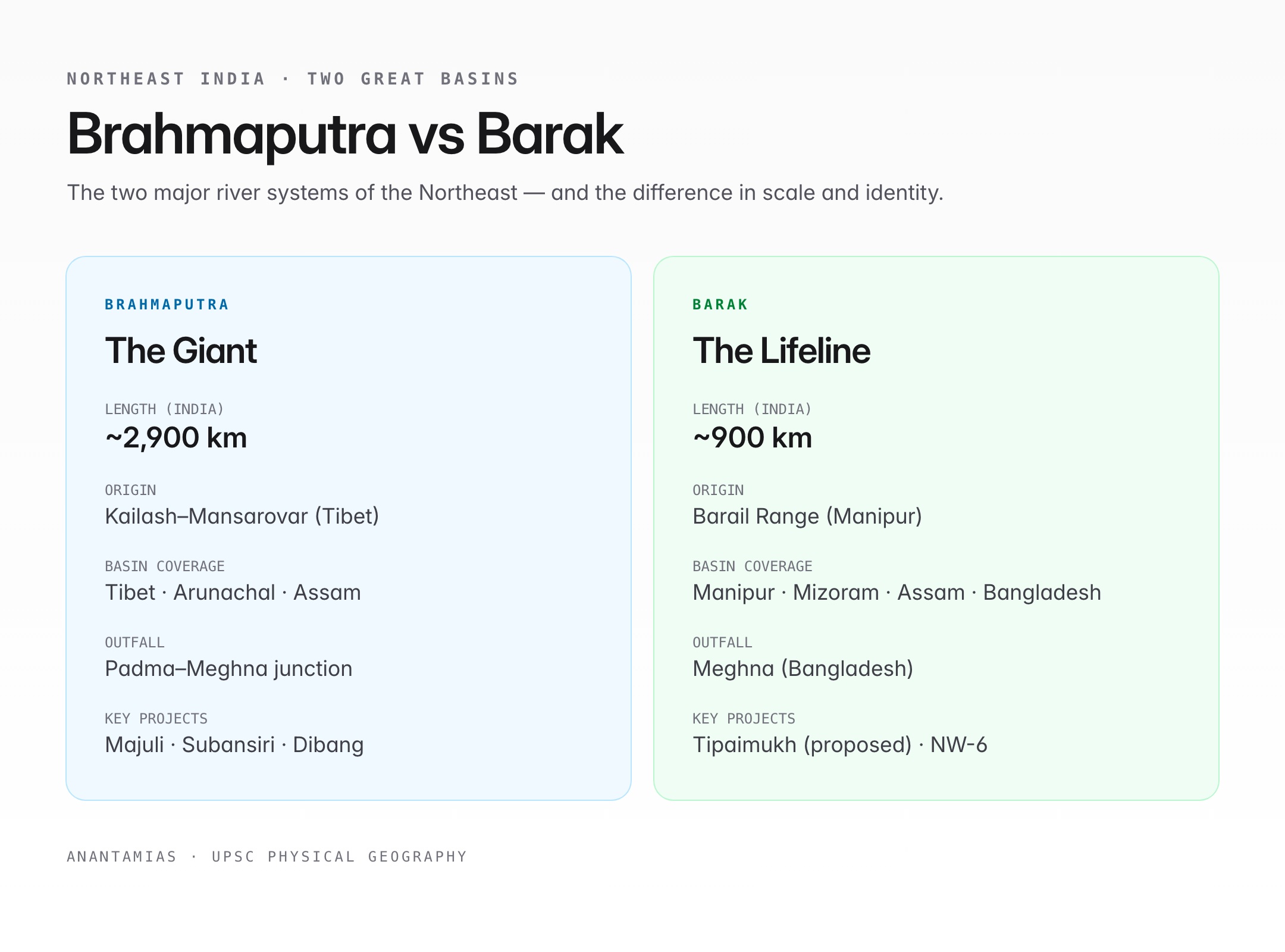
| Parameter | Brahmaputra | Barak |
|---|---|---|
| Length (India) | ~2,900 km | ~900 km |
| Basin | North-east (Tibet, Arunachal, Assam) | Manipur, Assam, Mizoram, Bangladesh |
| Origin | Kailash–Mansarovar | Barail Range, Manipur |
| Outfall | Padma–Meghna junction, Bangladesh | Meghna, Bangladesh |
| Key projects | Majuli island, Lower Subansiri, Dibang | Tipaimukh (proposed), NW-6 |
Recent Issues (2024–25)
- Silchar floods 2022 and 2024 — extensive embankment breaches; relief and rehabilitation remain incomplete.
- Tipaimukh Dam — India–Bangladesh negotiations revived; Meghalaya and Manipur tribal groups oppose on displacement and ecological grounds.
- Badarpur–Silchar–Vairengte rail and road upgrades — tied to multimodal Barak logistics.
- NW-6 development tenders — IWAI calls for terminal and dredging contracts to make the waterway fully operational.
Quick Revision
- Source: Barail Range, Manipur.
- Outfall: Meghna (Bangladesh) → Bay of Bengal.
- Indian states: Manipur, Nagaland, Mizoram, Assam (Barak Valley).
- Key hub: Silchar.
- NW-6: 121 km, Lakhipur to Bhanga.
- Proposed dam: Tipaimukh (Barak-Tuivai confluence).
UPSC Relevance
Prelims (GS Paper I): Map-based questions on Barak origin, Barak Valley districts, National Waterway 6, and Meghna system appear regularly. The Tipaimukh Dam, Barak-Surma-Meghna basin, and Silchar (19 May 1961) are frequently tested.
Mains (GS Paper I — Geography):
- Discuss the Barak as a secondary river system of the Northeast and its role in regional development.
- Examine recurrent flooding in the Barak Valley and the structural reforms needed.
Mains (GS Paper II — International Relations):
- Evaluate the role of inland waterways (including NW-6) in India's Act East policy and sub-regional engagement with Bangladesh and Myanmar.
- Discuss the Tipaimukh Dam issue in the context of India-Bangladesh water relations.
Mains (GS Paper III — Environment / Infrastructure): Flood management, seismic risk in the Northeast, and inland water transport as a sustainable logistics option.
Essay: Themes like "rivers as routes of integration," "the Northeast's forgotten basin," and "connectivity as foreign policy" fit the Barak story well.
Tell Google you want more of this.
Add Anantam IAS as a preferred sourceOne tap, and this site shows up more often in your own Top Stories, AI Overviews and AI Mode. Remove it any time.






