Why in news ?
India launched EOS-05 (GISAT-1A) aboard GSLV-F17 from Sriharikota on 4 September 2026. It is the successor to EOS-03/GISAT-1, which was lost in the GSLV-F10 failure in August 2021.
UPSC Relevance
Prelims
GS 3
Science and Technology- Developments and their Applications and Effects in Everyday Life.
Awareness in the fields of IT, Space, Computers, Robotics, Nano-technology, Bio-technology and issues relating to Intellectual Property Rights.
Mission Overview
- ISRO successfully launched the Earth Observation Satellite EOS-05 aboard the GSLV-F17 (19th flight of GSLV).
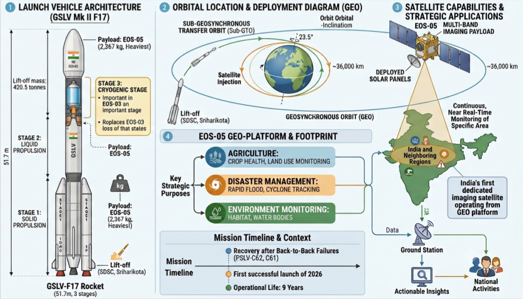
- Payload Capacity: At 2,367 kg, EOS-05 is the heaviest payload launched by the 3-stage, 51.7-meter GSLV Mk II rocket.
- Significance: This launch restores operational momentum after previous mission setbacks (including GSLV-F10/EOS-03 in 2021 and recent PSLV failures).
- EOS-05 is India’s 1st dedicated land-imaging satellite operating from geosynchronous altitude. India already had weather satellites in geostationary orbit and high-resolution land-imaging satellites such as Cartosat and Resourcesat in low Earth orbits.
Orbit and Positioning Characteristics
- Geosynchronous Orbit (GEO): EOS-05 is India’s first dedicated imaging satellite designed for continuous observation from a geosynchronous altitude (~36,000 km).
- Orbit Injected: Placed initially into a Sub-Geosynchronous Transfer Orbit (Sub-GTO); on-board propulsion systems will raise it to its final operational geostationary/geosynchronous platform.
- Thus, launch success ≠ mission commissioning.
- Geo vs. LEO/Sun-Synchronous Remote Sensing:
- Low Earth Orbit (LEO) Imaging: Provides finer resolution detail, but constantly moves relative to Earth, taking days to return to the same location.
- Geosynchronous Imaging: Fixed relative to Earth’s rotation, enabling high temporal resolution (frequent revisit capability) over broad regions at the cost of ultra-fine spatial resolution.
A crucial Prelims distinction : types of orbits
- Geosynchronous: orbital period equals one sidereal day (23 hours, 56 minutes and 4 seconds) ; the orbit may be inclined or elliptical.
- Geostationary: a special GSO that is circular, equatorial and has near-zero inclination; therefore the satellite appears fixed over one longitude.
- Sun-synchronous: usually a near-polar low-Earth orbit whose plane precesses at roughly the rate of Earth’s revolution around the Sun, ensuring observations at similar local solar times.
- Polar: high inclination allowing successive passes over or near both poles.
Trap: Sun-synchronous and polar are not synonymous.
Technical Specifications
- Sensor Capabilities: EOS-05 carries a 700-mm Ritchey–Chrétien telescope and multispectral/hyperspectral sensors covering VNIR (visible and near-infrared) and SWIR (short-wave infrared) moving beyond simply producing photographs towards spectral intelligence about materials and their condition to distinguish land cover, vegetation, and thermal variations.
- Lifespan & Power: an operational life of 7 to 9 years and equipped with deployable solar panels.
- Launch Vehicle Architecture: GSLV uses a 3-stage structure (Solid primary stage, Liquid Vikas-based second stage, and an Indigenous Cryogenic Upper Stage – CUS).
The central trade-off: spatial vs temporal resolution
| LEO imagers | EOS-05 in GEO |
| ~500–800 km altitude | ~35,786 km |
| Much higher spatial resolution | Coarser: ~42 m to 318 m |
| Revisit generally measured in days | Selected areas potentially every ~5 min |
| Different ground tracks | Persistent view of the same broad region |
| What exactly is there? | What is changing, and when? |
- EOS-05 therefore complements rather than replaces LEO satellites.
- A mature Indian remote-sensing architecture can be understood as:
- Cartosat/Resourcesat: high spatial detail — What is it?
- RISAT/NISAR: radar, day-night and cloud-penetrating — What is happening despite clouds?
- EOS-05: persistent optical observation — When did the change occur?
- This is essentially a “tip-and-cue” architecture: GEO detects an unusual change, while higher-resolution LEO satellites investigate it.
Applications & Strategic Importance
- Disaster Risk Reduction (DRR): Real-time, continuous tracking of rapid natural hazard dynamics such as flash floods, glacial lake outburst floods (GLOFs), forest fires, and cyclone tracking.
- Agricultural & Environmental Governance: Continuous monitoring of crop growth cycles, stubble burning detection (identifying timing shifts), forest dynamics, and water resource management.
- Stubble burning — governance lesson – Polar satellites may miss fires that occur outside their predictable overpass windows. A GEO satellite can repeatedly observe north India and reduce this temporal blind spot.
- Hyperspectral and SWIR data can support crop classification, acreage estimation, moisture-stress detection and yield forecasting, complementing programmes such as PMFBY, FASAL and CHAMAN.
- Strategic & Security Applications: Near real-time “eye in the sky” surveillance capability along national borders and maritime zones to enhance national security infrastructure.
- Policy Data Integration: Acts as a persistent data source for evidence-based decision-making in climate adaptation, land-use planning, and regional development.
Challenges & Policy Imperatives
- Data Processing Pipeline: Translating massive feeds of raw satellite imagery into actionable, real-time insights requires robust ground station analytics and open-access data distribution frameworks.
- Launch Vehicle Reliability: Ensuring long-term consistency in the GSLV cryogenic stage and standardizing manufacturing protocols across PSLV/GSLV variants to maintain operational cadence.
- The recent GSLV success does not erase problems in the PSLV. The PSLV is India’s commercial workhorse, and repeated failures have implications for commercial credibility and the emerging private launch ecosystem.
- Coarse spatial resolution: ~42 m at best makes it unsuitable for detailed object identification.
- Atmospheric interference: At 36,000 km, the signal travels through a long atmospheric path, complicating atmospheric correction and reducing signal quality.
- Poorer high-latitude geometry: Himalayan regions are viewed at more oblique angles from an equatorial geostationary position.
- Clouds: Optical sensors cannot see through clouds. This is particularly significant because monsoon floods, cyclones and kharif agriculture coincide with heavy cloud cover.
- No reflective-band night imaging: Unlike radar, optical multispectral/hyperspectral observation is fundamentally constrained by illumination.
Hence NISAR and other radar capabilities remain crucial. India’s broader weakness is not the lack of a single satellite but the need for a balanced optical-radar constellation.
The Himalayan disaster lesson: detection is not warning
- The August 2026 Bhote Koshi disaster in Nepal provides a critical test case.
- An ice-and-rock avalanche from the Langtang Lirung region temporarily dammed a stream; the dam failed, producing a destructive debris-laden surge. Early descriptions called it a Glacial Lake Outburst Flood (GLOF), but this distinction matters: a strict GLOF requires drainage of a pre-existing glacial lake. Here, the immediate mechanism was an ice-and-rock avalanche followed by failure of a landslide dam.
- Nepal had satellite monitoring, glacial-lake inventories and early-warning capabilities. Yet the hazard originated from an uncatalogued unstable rock face, rather than a monitored glacial lake.
- EOS-05 could potentially help detect progressive slope movement, glacier change or lake expansion, but it could not necessarily prevent an instantaneous collapse. With the flood reportedly reaching downstream locations within minutes, there was insufficient warning time for satellite observation alone to save lives.
- Therefore, Satellites reduce the detection problem; they do not automatically solve the warning-to-action problem.
- Where lead time approaches zero, hazard zonation, land-use regulation and safer infrastructure siting become more important than faster imagery.
- This is especially relevant to the Himalayas, where India must also address transboundary data-sharing with Nepal, China and other downstream states.
The institutional layer
- The value of EOS-05 depends on institutions converting imagery into action. The National Geospatial Policy 2022 and Geospatial Data Guidelines have liberalised access to geospatial information.
- Platforms such as Bhuvan, NRSC’s data systems and the National Database for Emergency Management (NDEM) are important for dissemination and disaster response.
- The broader ecosystem must include government agencies, private firms, universities and analysts.
EOS-05 represents a shift from periodic observation to persistent observation. Its greatest contribution is not seeing smaller objects, but seeing change unfold in time.
Technology gives us sight; institutions decide whether we see.
EOS-05 can provide the eye. India still needs the analysts, data-sharing arrangements, hazard maps, regulatory institutions and last-mile warning systems that turn that eye into public safety.
Practice Question
In light of recent operational successes and launch vehicle setbacks, analyze how EOS-05 mission enhances India’s disaster management and strategic security, and discuss the critical reliability challenges facing ISRO’s launch vehicles. (15 marks)
UPSC Prelims Practice Question
Q. With reference to India’s space missions and Earth Observation Satellites (EOS), consider the following statements:
1. EOS-05 is India’s first dedicated Earth imaging satellite placed in a Geosynchronous Orbit.
2. Satellites placed in Low Earth Orbit (LEO) offer continuous, 24/7 observation of a fixed geographical location, unlike Geosynchronous imaging satellites.
3. The GSLV Mk II launch vehicle utilizes a three-stage propulsion system consisting of solid core with liquid strap-ons, a liquid second stage, and an indigenous cryogenic upper stage.
Which of the statements given above is/are correct?
(a) 1 and 2 only
(b) 1 and 3 only
(c) 2 and 3 only
(d) 1, 2, and 3
Answer: (b) 1 and 3 only
Tell Google you want more of this.
Add Anantam IAS as a preferred sourceOne tap, and this site shows up more often in your own Top Stories, AI Overviews and AI Mode. Remove it any time.