Why in News?
India is heading into a summer marked by multiple climate extremes. A fresh Western Disturbance is expected to bring unseasonal rainfall to northern India, while the possibility of an El Niño year in 2026 raises concerns over a weaker monsoon and more intense heatwaves.
Rising humidity levels are already making temperatures feel far worse than the thermometer actually records. As a result, India is likely to witness more frequent and severe heatwave conditions in 2026.
| UPSC Relevance: GS-1 Geography: Physical Geography; GS-3 Environment: Climate Change Prelims: Western Disturbance, ENSO, El Niño, La Niña, Heat Wave, Wet Bulb Temperature, Heat Index |
1. What is a Western Disturbance?
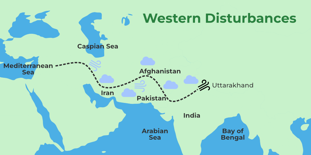
- Western Disturbances are eastward-moving rain-bearing weather systems that originate beyond Afghanistan and Iran. They gather moisture from the Mediterranean Sea, Black Sea, Caspian Sea, and Arabian Sea before reaching the Indian subcontinent.
- These systems are generally extra-tropical cyclones formed due to the interaction between polar and tropical air masses.
- They travel within the subtropical westerly jet stream, a fast-moving high-altitude air current flowing from west to east over the Himalayan and Tibetan region.
- Western Disturbances occur mainly during the winter months from December to March. They significantly influence the weather of northwestern India and neighbouring regions such as Pakistan, Afghanistan, and Tajikistan.
- Importance for India:
- Bring winter rainfall to northwestern India.
- Cause snowfall in the Himalayas, which is crucial for glaciers and river systems.
- Support rabi crops such as wheat and mustard.
- Sometimes trigger hailstorms, flash floods, and unseasonal rain, damaging crops and infrastructure.
2. 2026- An El Niño Year:
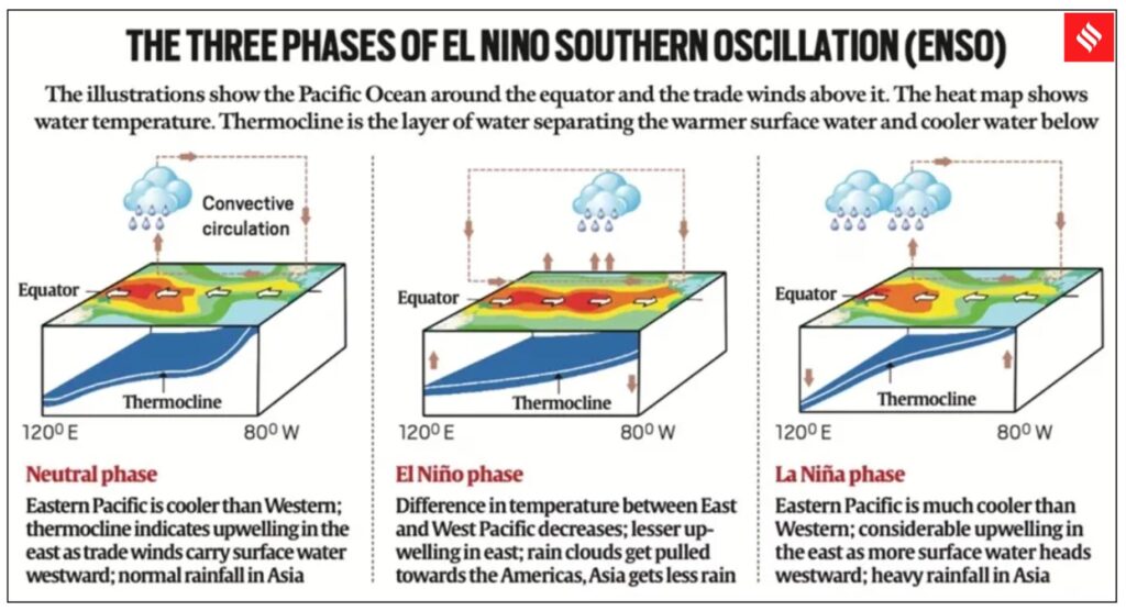
- The El Niño Southern Oscillation (ENSO) is a major climate phenomenon linked to changes in sea surface temperatures in the Pacific Ocean and shifts in atmospheric circulation patterns. ENSO affects weather systems across the globe, including the Indian monsoon. ENSO has three phases. These phases occur irregularly every 2 to 7 years.
- El Niño (warm phase)
- La Niña (cool phase)
- Neutral phase
Neutral Phase:
- Under normal conditions, the eastern Pacific Ocean near South America remains cooler than the western Pacific near Indonesia and the Philippines. This happens because easterly trade winds push warm surface waters westward, allowing cooler deep waters to rise in the east.
El Niño
- During El Niño, the eastern Pacific Ocean becomes unusually warm. This weakens the movement of moisture-bearing winds towards India and disrupts the southwest monsoon.
- Impact of El Niño on India:
- Weak or delayed monsoon.
- Longer dry spells in agricultural regions.
- Reduced crop productivity.
- Increased frequency and intensity of heatwaves.
- Higher risk of drought-like conditions.
The US Climate Prediction Centre has projected a 61% probability of El Niño developing between May and July 2026, with conditions likely to continue till the end of the year.
La Niña
- La Niña represents the opposite phase, where the eastern Pacific Ocean becomes cooler than normal. This strengthens moisture-laden winds towards India and generally supports a stronger monsoon.
- Impact of La Niña on India:
- Better monsoon rainfall.
- Improved agricultural output.
- Increased risk of floods and crop damage in extreme rainfall events.
3. What is a Heat Wave?
- A heat wave is a prolonged period of abnormally high temperatures compared to the normal climate of a region. The definition varies across regions because “normal” temperatures differ from place to place.
- Heatwave intensity can become worse due to high humidity, strong hot winds, and long duration of heat exposure.
- IMD Criteria for Declaring a Heat Wave: The India Meteorological Department declares a heat wave when the maximum temperature reaches at least 40°C in plains or 30°C in hilly regions. After this threshold is crossed, heatwaves are classified using two methods:
- Based on Departure from Normal Temperature: Heat Wave: 4.5°C to 6.4°C above normal. Severe Heat Wave: More than 6.4°C above normal.
- Based on Actual Maximum Temperature: Heat Wave: Temperature reaches 45°C or more. Severe Heat Wave: Temperature reaches 47°C or more.
- Coastal Areas: For coastal stations, humidity is also considered. A heat wave may be declared if the maximum temperature is at least 37°C, and the temperature is 4.5°C above normal.
These conditions must occur in at least two stations of a meteorological subdivision for two consecutive days. The official declaration is made on the second day.
4. What is Wet Bulb Temperature?
- The temperature normally reported in weather forecasts is called the Dry Bulb Temperature. It measures heat but does not account for moisture in the air.
- Wet Bulb Temperature measures the lowest temperature that can be achieved through evaporation. It shows how effectively sweat can evaporate from the human body and cool it down. In simple terms, wet bulb temperature indicates the limit to which the human body can cool itself.
- Humidity plays a major role in heat stress. When humidity is high:
- Sweat evaporates more slowly
- The body struggles to cool itself
- Risk of heat exhaustion and heatstroke increases.
- Normally, wet bulb temperature remains lower than dry bulb temperature. The gap becomes larger when the air is dry.
- According to the Sixth Assessment Report of the Intergovernmental Panel on Climate Change, sustained wet bulb temperatures above 35°C can become fatal for humans.
- Wet bulb temperatures above 31°C are dangerous during intense physical activity. Vulnerable Groups: Outdoor labourers, elderly people, children, individuals with heart disease or diabetes.
However, the IPCC notes that such extreme wet bulb temperatures are unlikely to persist for long durations in most regions.
5. What Does “Feels Like” Temperature Mean?
- “Feels like” temperature, also known as apparent temperature, combines actual air temperature with humidity and wind conditions to show how hot or cold the weather feels to the human body. For example:
- A 40°C day in Delhi may feel less uncomfortable because the air is relatively dry.
- A 40°C day in Palakkad, Kerala, may feel much hotter because of high humidity levels.
- In humid conditions, sweat does not evaporate efficiently, making the body feel hotter than the actual temperature. Thus, the “feels like” temperature in coastal or humid regions can rise close to 45°C even if the thermometer shows 40°C.
- Heat Index: The combination of temperature and humidity is called the heat index. It reflects how hot conditions feel to humans.
- Wind Chill Index: Similarly, the wind chill index combines temperature and wind speed to measure how cold weather feels when wind removes the thin insulating layer of warm air around the body.
India’s climate challenges are becoming increasingly interconnected. Western Disturbances are causing erratic rainfall, El Niño conditions threaten weaker monsoons and stronger heatwaves, and rising humidity is increasing heat stress across the country.
Tell Google you want more of this.
Add Anantam IAS as a preferred sourceOne tap, and this site shows up more often in your own Top Stories, AI Overviews and AI Mode. Remove it any time.