Why in News?
The first phase of the National Maritime Heritage Complex at Lothal, Gujarat, is nearing its planned opening. The Indian Express reported that visitors will be able to walk through reconstructed Harappan streets, markets, civic spaces and dockyards rather than encounter the settlement only through display cases.
A Ministry of Ports, Shipping and Waterways review had set July as the target for completing Phase 1A. The project joins a modern maritime museum to an archaeological landscape associated with Harappan urbanism, craft production and long-distance exchange.
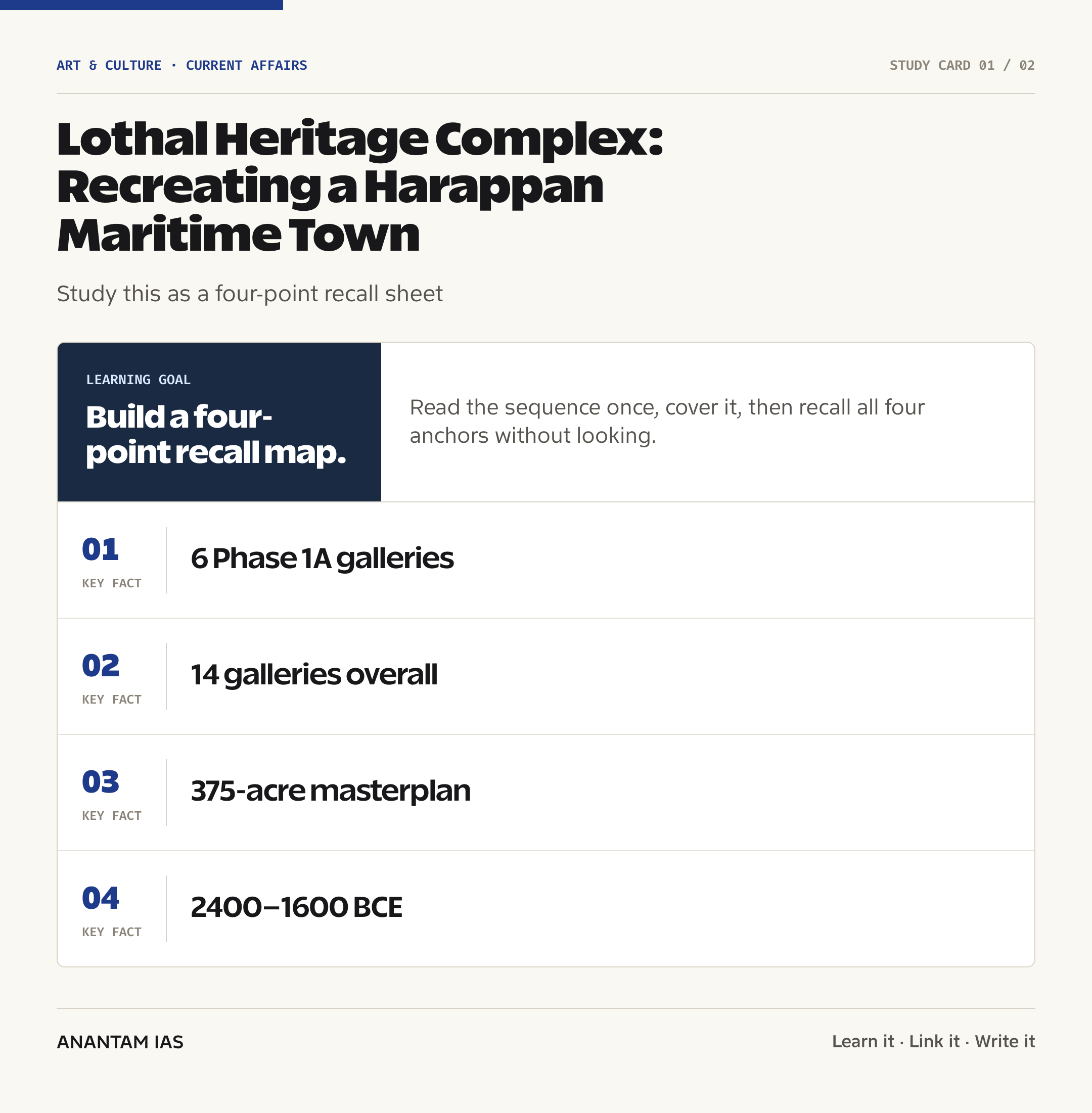
- Phase 1A includes six museum galleries, a recreated Lothal township, aquatic and common-area theming, a jetty walkway and Indian Navy artefacts.
- The Indian Express reported that the recreated settlement will place Harappan streets, markets, houses and civic spaces within a living-history experience.
- The full museum plan provides for 14 interconnected galleries covering maritime history from Harappan exchange to modern shipping and naval development.
- The 375-acre masterplan is organised through an architectural reading of Harappan upper, middle and lower town principles.
- India has signed maritime-heritage collaboration MoUs with 10 countries, while the ministry has sought wider partnerships and a viable long-term revenue model.
The development matters in the context of:
- The project matters in the context of converting archaeological evidence into public history without blurring the line between excavated remains and modern reconstruction.
- It connects maritime heritage with museum policy, tourism, local livelihoods, research and cultural diplomacy.
- It also brings focus back to Lothal’s basin, town plan, bead industry and trade evidence within the wider Indus Valley Civilisation.
UPSC Relevance
Prelims Relevance
- Lothal is in Dholka taluk of Ahmedabad district, Gujarat, near the Bhogava River, a tributary of the Sabarmati, and the Gulf of Khambat.
- The heritage submission records Harappan occupation at Lothal broadly between 2400 BCE and 1600 BCE.
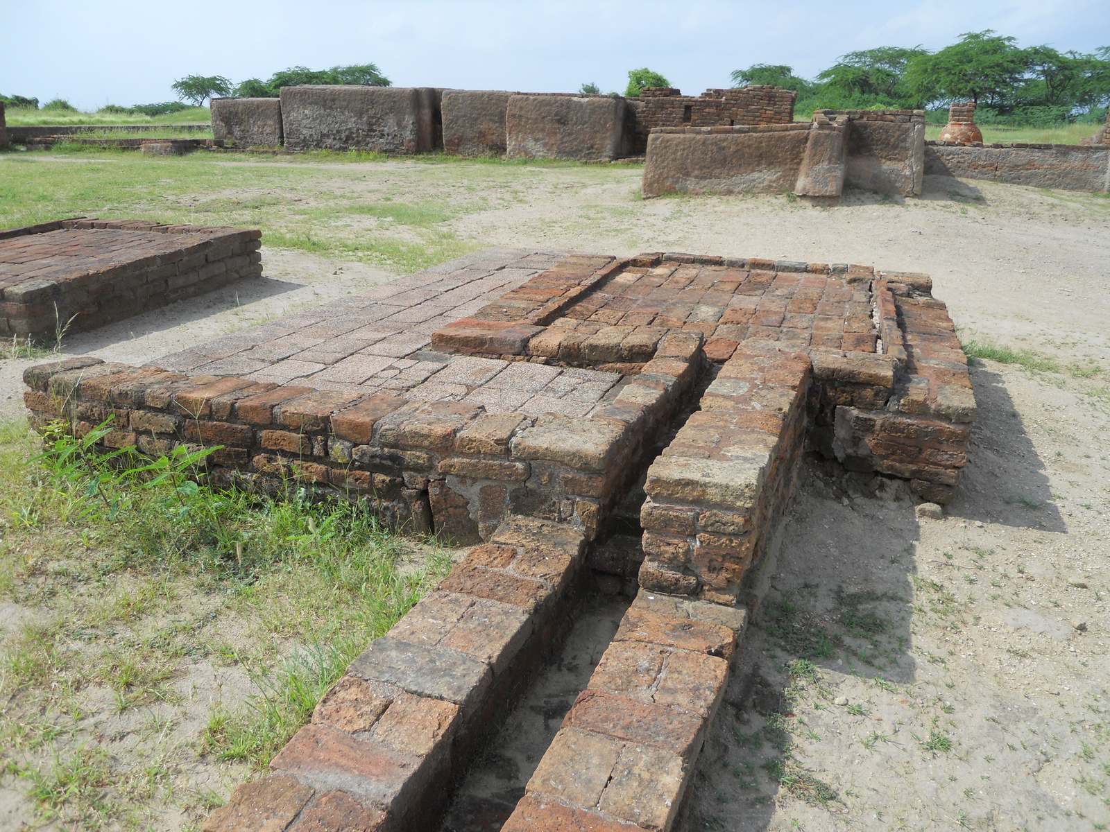
- The settlement had an upper town and lower town; the upper town stood on elevated mud-brick platforms in the south-eastern part.
- A large brick-lined basin with inlet and outlet channels is identified in official heritage accounts as a tidal dockyard.
- A wharf-like platform, a structure identified as a warehouse, stone anchors, marine shells and Persian Gulf-linked seals support a maritime interpretation.
- The lower town contains evidence of specialised crafts, including a bead-making industry, weights, sealings and other production activity.
- Lothal has been on India’s UNESCO Tentative List since 2014; it is not an inscribed World Heritage Site.
- The excavated remains are protected and maintained by the Archaeological Survey of India under the Ancient Monuments and Archaeological Sites and Remains Act, 1958.
- NMHC is being developed by the Ministry of Ports, Shipping and Waterways under the Sagarmala Programme.
Mains Relevance
GS Paper 1
- Use Lothal to explain Harappan town planning, hydraulic adaptation, craft specialisation and overseas exchange.
- Assess how museums, reconstructions and interpretation centres can widen access to archaeological heritage while preserving authenticity.
GS Paper 3
- Examine heritage infrastructure as a link between tourism, local enterprise and employment.
- Discuss resilient planning for a large visitor complex in a landscape shaped by flooding, siltation and climate risk.
Essay
- The sea as a civilisational bridge: Ports connect commerce, technology, migration and cultural exchange across time.
- Preserving the past, designing the future: Public history succeeds when spectacle remains accountable to evidence.
Background and Context
Lothal in the Harappan World
Lothal was a compact but strategically placed Harappan settlement in the estuarine landscape of south-eastern Gujarat.
- The site lies near the Bhogava River, a tributary of the Sabarmati, with access towards the Gulf of Khambat; changing channels and siltation have altered the present landscape.
- The UNESCO Tentative List description places its Harappan cultural sequence broadly between 2400 BCE and 1600 BCE, covering mature and later phases of the civilisation.
- Excavations led by S. R. Rao for the Archaeological Survey of India in the 1950s revealed the town plan, basin, warehouse-like platform, craft areas, houses, drains and cemetery.
- Lothal should be read alongside larger Harappan centres, but its scale and coastal location give it a distinct role in studying production and exchange.
- The wider civilisation included regional adaptations rather than one identical urban template. Compare Lothal’s port-oriented setting with Dholavira’s water-centred urbanism in Kutch.
Town Planning and Flood Adaptation
The settlement combined zoning, drainage and raised construction in a landscape repeatedly exposed to water.
- Lothal had two primary zones: an elevated upper town in the south-east and a larger lower town associated with residences, workshops and commercial activity.
- Mud-brick platforms raised important buildings above the surrounding level, while peripheral walls and elevated plinths suggest responses to flood risk.
- Streets, bathing platforms and drains indicate civic organisation. Drainage was linked to household and street design rather than added as a separate afterthought.
- The settlement’s spatial order supports a broader pattern described in Harappan architecture and town planning: standardised materials, functional zoning and water management.
- Flood layers and the eventual silting of channels also show a limit to urban engineering: environmental change could disrupt both settlement and access routes.
The Basin and Maritime Interpretation
Lothal’s most discussed feature is a large brick-lined basin interpreted in official heritage records as a tidal dockyard.
- The UNESCO Tentative List submission records the basin at about 217 metres long and 26 metres wide, with vertical walls and identified inlet and outlet channels.
- A wharf-like platform and a nearby structure identified as a warehouse help explain how goods may have moved between boats, storage and the town.
- Stone anchors, marine shells and sealings linked to the Persian Gulf add material context to the dockyard interpretation, though archaeological claims should be presented with their evidentiary basis rather than as spectacle.
- Boats are understood to have approached through a tidal creek connected to the Gulf of Khambat. Control of water level would have been essential in a high-tidal-range environment.
- The phrase “world’s oldest dockyard” is common in public accounts. A careful answer can call it one of the earliest known engineered maritime basins while noting that the dockyard identification is an archaeological interpretation.
Crafts, Trade and Economic Organisation
Lothal’s importance rests not only on seafaring but on the production system that made exchange possible.
- The lower town preserves evidence of a bead-making workshop, including furnaces and craft debris associated with processing semi-precious materials.
- Standardised weights, seals and sealings point to systems for measurement, identification and control within trade and administration.
- Carnelian beads, shell objects and metalwork show skilled production and access to raw materials moving through regional networks.
- Finds connected with the Persian Gulf and broader West Asian exchange indicate that Harappan commerce operated through overland, riverine and maritime routes, not through a single port alone.
- The warehouse interpretation links storage to accountable movement of goods. It can be studied with other Harappan archaeological findings such as weights, baked-brick houses and craft tools.
What the Heritage Complex Will Contain
The National Maritime Heritage Complex is planned as a museum, research, tourism and public-space ecosystem rather than a single gallery building.
- The Indian Express reported that the main maritime museum covers roughly seven lakh square feet and uses monumental elevated forms inspired by the flood-resistant character of Harappan construction.
- The final museum sequence is planned around 14 galleries; Phase 1A opens the first six, including maritime narratives and a Navy and Coast Guard component with external artefacts.
- A recreated Lothal settlement, reported at 80 metres by 80 metres, is intended to let visitors move through streets, houses, markets, civic spaces and the dock environment.
- The display plan uses suspended artefacts, tactile exhibits, water tanks, projections and underwater-themed installations to narrate periods from Harappan trade to modern shipping.
- The larger masterplan also provides for a lighthouse museum, children’s spaces, a Bageecha complex, coastal-state pavilions, public plazas, research and training facilities, eco-resorts and theme parks.
- The ministry’s Sagarmala project page says the 375-acre plan adapts the idea of a Harappan citadel, middle town and lower town to organise museum, garden, recreation and hospitality functions.
Phasing, Governance and Partnerships
The project’s phased structure separates the near-complete public museum components from later facilities that need additional funding and partnerships.
- Phase 1A is being executed through the Engineering, Procurement and Construction model and covers six galleries, the Lothal township, aquatic theming, a jetty walkway and naval artefacts.
- The May ministry review said Phase 1B would add eight galleries, a lighthouse museum, the Bageecha complex, other visitor components and a 50-dome theatre, with an investment of about ₹3,000 crore.
- The Union Cabinet approved the project framework on 9 October 2024 and gave in-principle approval to the later phases subject to resource mobilisation.
- A separate society under the Societies Registration Act, 1860, governed by a council headed by the Union Minister for Ports, Shipping and Waterways, is to manage future implementation and operation.
- The Directorate General of Lighthouses and Lightships is to fund the lighthouse museum, while Phase 2 relies on land subleasing and public-private participation for hospitality and recreation components.
- MoUs with maritime countries can support loans, replicas, research and curatorial exchange, but international reach must complement local scholarship and community participation.
Heritage Interpretation and Public Value
A reconstruction can make archaeology legible, but it must keep evidence, inference and imagination visibly distinct.
- The excavated site and the modern complex serve different purposes: the former is primary archaeological evidence, while the latter is an interpretive and educational environment.
- Recreated houses, markets or dock scenes should disclose which elements follow excavated plans, which rely on comparative Harappan evidence and which are curatorial reconstructions.
- High visitor footfall can support guides, crafts, transport and hospitality in nearby villages, but benefits depend on local procurement, skill development and fair access for community enterprises.
- The complex needs a stable revenue model for conservation, staffing, exhibit renewal and maintenance. Ticket income alone can create pressure to favour entertainment over research integrity.
- Flood-resilient infrastructure, drainage, heat mitigation and carrying-capacity planning are essential because the project sits in a sensitive estuarine and archaeological landscape.
- Success should be measured through learning outcomes, conservation standards, accessible design, original research and local livelihoods, not only through visitor numbers.
Way Forward
Protect the archaeological core
- Maintain a clear buffer between the ASI-protected remains and new construction, traffic, vibration, drainage or commercial activity.
- Use condition mapping, hydrological monitoring and preventive conservation for brick structures exposed to salts, moisture and weathering.
Label reconstruction honestly
- Create a visible evidence scale for each reconstruction: excavated, inferred or illustrative.
- Publish curatorial notes and source trails so teachers, students and researchers can test claims instead of treating every immersive scene as a recovered fact.
Build a research-led museum
- Institutionalise partnerships among the ASI, universities, maritime museums, Navy, Coast Guard and coastal communities.
- Rotate artefacts and temporary exhibitions to include shipbuilding, navigation, monsoon knowledge, ports, labour, fisheries and Indian Ocean connections.
Share economic gains locally
- Train local residents as guides, conservators, hospitality workers and producers of evidence-based educational material.
- Tie procurement and enterprise spaces to nearby villages and artisan groups, with public reporting on jobs, accessibility and ecological performance.
Conclusion
Lothal offers a compact lesson in how geography, hydraulic knowledge, craft production and exchange came together in a Harappan settlement. The new complex can make that system easier to understand if it treats archaeology as evidence rather than merely as a theme.
The strongest version of NMHC will combine immersive storytelling with conservation, transparent interpretation, research and local benefit. Its public value will come from helping visitors distinguish what was excavated, what scholars infer and how India’s maritime history continued to evolve.
UPSC Practice Questions
Prelims MCQ 1
With reference to Lothal, consider the following statements:
- It is located near the Bhogava River, a tributary of the Sabarmati.
- Its upper town was raised on mud-brick platforms in the south-eastern part of the settlement.
- It is an inscribed UNESCO World Heritage Site.
How many of the above statements are correct?
(a) Only one (b) Only two (c) All three (d) None
Answer: (b) Only two
Explanation:
Statements 1 and 2 are correct. Lothal is near the Bhogava-Sabarmati system, and its upper town occupied raised platforms. It is on India’s UNESCO Tentative List, not the inscribed World Heritage List.
Prelims MCQ 2
Which one of the following correctly describes Phase 1A of the National Maritime Heritage Complex?
(a) Six galleries, a recreated Lothal township, jetty walkway and naval artefacts (b) Coastal-state pavilions, eco-resorts and four theme parks only (c) Eight galleries and a lighthouse museum only (d) An archaeological excavation programme without a museum
Answer: (a) Six galleries, a recreated Lothal township, jetty walkway and naval artefacts
Explanation:
Phase 1A contains the first six museum galleries and the principal Lothal-themed visitor components. Coastal-state pavilions and major hospitality or recreation elements belong to later phases.
UPSC Mains Questions
- Lothal reveals how urban planning, craft specialisation and maritime exchange reinforced one another in the Harappan economy. Discuss with reference to archaeological evidence and the site’s environmental setting. (250 words)
- Immersive reconstruction can widen access to archaeology, but it can also turn interpretation into apparent fact. Evaluate how the National Maritime Heritage Complex should balance experience, authenticity and conservation. (250 words)
- Heritage infrastructure produces durable public value only when conservation, scholarship and local livelihoods are designed together. Examine in the context of the National Maritime Heritage Complex at Lothal. (150 words)
Sources: PIB, Ministry of Ports, Shipping and Waterways and The Indian Express.
Frequently Asked Questions
What is Lothal famous for?
Lothal is a Harappan settlement in Gujarat known for its planned upper and lower town, drainage, bead-making industry, warehouse-like structure and a large brick-lined basin identified in official heritage records as a tidal dockyard. Its finds help explain craft production and long-distance exchange across the Gulf region.
Where is Lothal located?
Lothal is in Dholka taluk of Ahmedabad district, Gujarat, near the village of Saragwala. The archaeological site lies near the Bhogava River, a tributary of the Sabarmati, in the wider Gulf of Khambat landscape. Ancient water channels and modern siltation make its maritime geography different from today’s appearance.
Is Lothal a UNESCO World Heritage Site?
No. The Archaeological Remains of a Harappa Port-Town, Lothal, were submitted to UNESCO’s Tentative List in 2014 under the cultural category. A Tentative List entry is a site a country may consider for nomination; it is not the same as inscription on the World Heritage List.
What is the National Maritime Heritage Complex?
The National Maritime Heritage Complex is a phased museum and tourism project of the Ministry of Ports, Shipping and Waterways under Sagarmala. It combines galleries on India’s maritime history with a recreated Lothal township, naval artefacts, public landscapes, research and training plans, and later lighthouse, state-pavilion and hospitality components.
What does NMHC Phase 1A include?
Phase 1A includes six museum galleries, the recreated Lothal township, aquatic and common-area theming, a jetty walkway and Indian Navy artefacts. It is the opening museum package within the larger plan for 14 galleries and additional cultural, research, recreation and visitor facilities to be delivered in later phases.
Why is Lothal important for maritime history?
Lothal combines a basin interpreted as a tidal dockyard with a wharf-like platform, warehouse evidence, stone anchors, marine shells, seals and specialised craft production. Together, these finds support the study of how Harappan settlements connected manufacturing, storage, river access and overseas exchange with the Persian Gulf and West Asia.
Tell Google you want more of this.
Add Anantam IAS as a preferred sourceOne tap, and this site shows up more often in your own Top Stories, AI Overviews and AI Mode. Remove it any time.