Desertification is land degradation in arid, semi-arid and dry sub-humid areas, caused mainly by human activity and climatic variation. That is the UNCCD definition, and the wording matters: desertification is not deserts advancing outward, it is productive dryland losing its productivity. ISRO’s Atlas puts 97.85 million hectares of India’s 328.72 million hectares under degradation in 2018-19, which is 29.7 per cent of the country and one of its largest, least visible resource problems.
Desertification and Land Degradation Are Not the Same Thing
| Land degradation | Desertification | |
|---|---|---|
| Where | Any climatic zone | Only arid, semi-arid and dry sub-humid zones |
| What | Long-term loss of ecosystem function and productivity | Land degradation occurring specifically in drylands |
| Scope in India | About 97.85 million hectares (29.7% of area) | Drylands subset of the above |
| Governing convention | Broadly the CBD and UNCCD | UNCCD (1994), which India ratified in 1996 |
Every case of desertification is land degradation. Not every case of land degradation is desertification.
The Indian Picture
The authoritative source is ISRO’s Desertification and Land Degradation Atlas of India, produced by the Space Applications Centre, Ahmedabad.
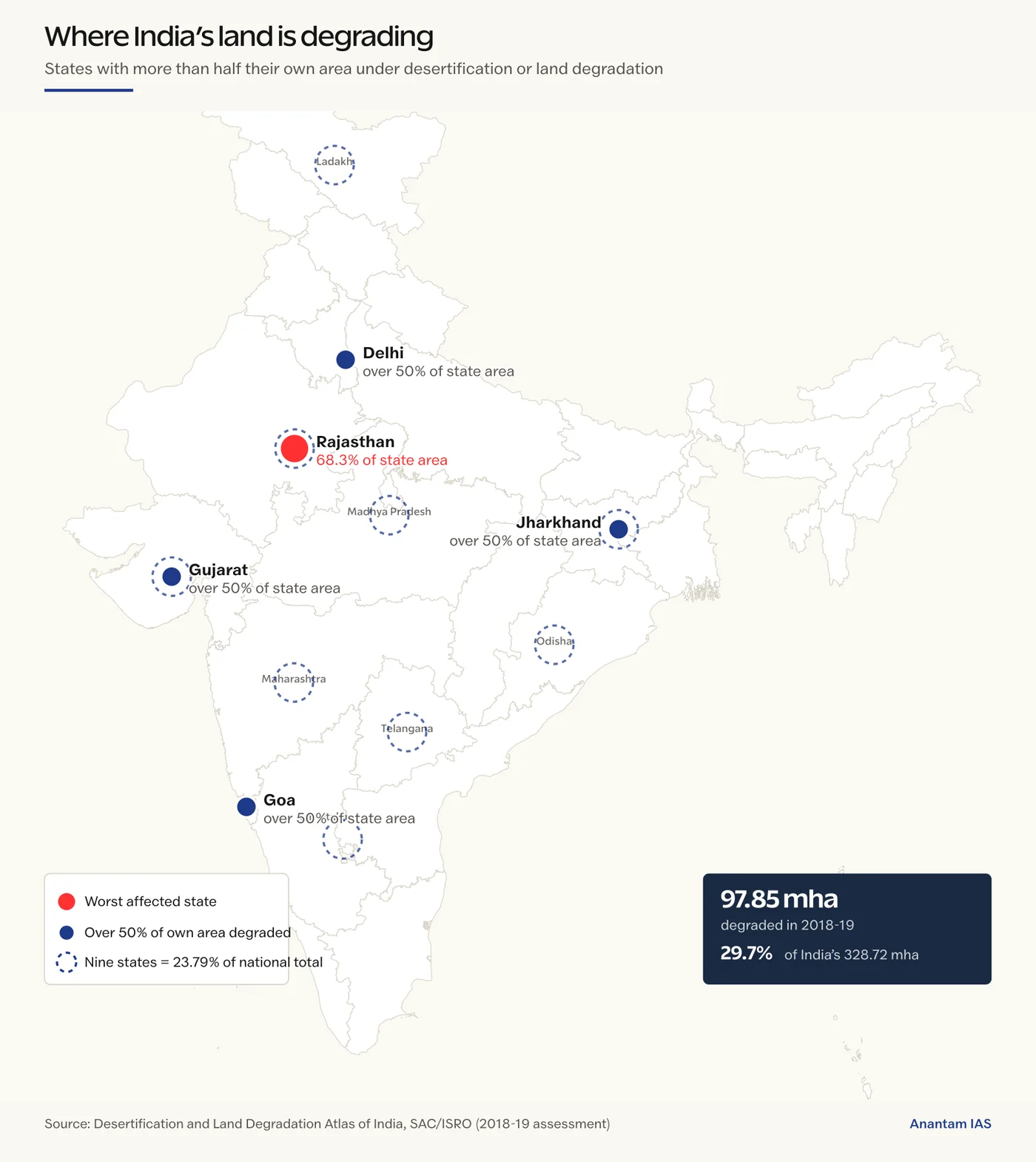
- Roughly 97.85 million hectares, about 29.7 per cent of India’s geographical area, is under degradation.
- Water erosion is the single largest process at about 10.98 per cent of the total geographical area, with loss of soil cover at 11.01 per cent and vegetation degradation at 9.15 per cent.
- Wind erosion accounts for about 5.46 per cent, concentrated in Rajasthan and Gujarat.
- Of the national total, 83.69 million hectares was specifically desertification, up from 81.48 mha in 2003-05 and 82.64 mha in 2011-13.
- Five states and union territories have more than half their own area degraded: Rajasthan (68.3 per cent), Delhi, Gujarat, Goa and Jharkhand. Nine states together account for 23.79 per cent of national desertification: Rajasthan, Maharashtra, Gujarat, Karnataka, Ladakh, Jharkhand, Odisha, Madhya Pradesh and Telangana.
Causes
Natural processes set the stage, but the triggers are almost always human.
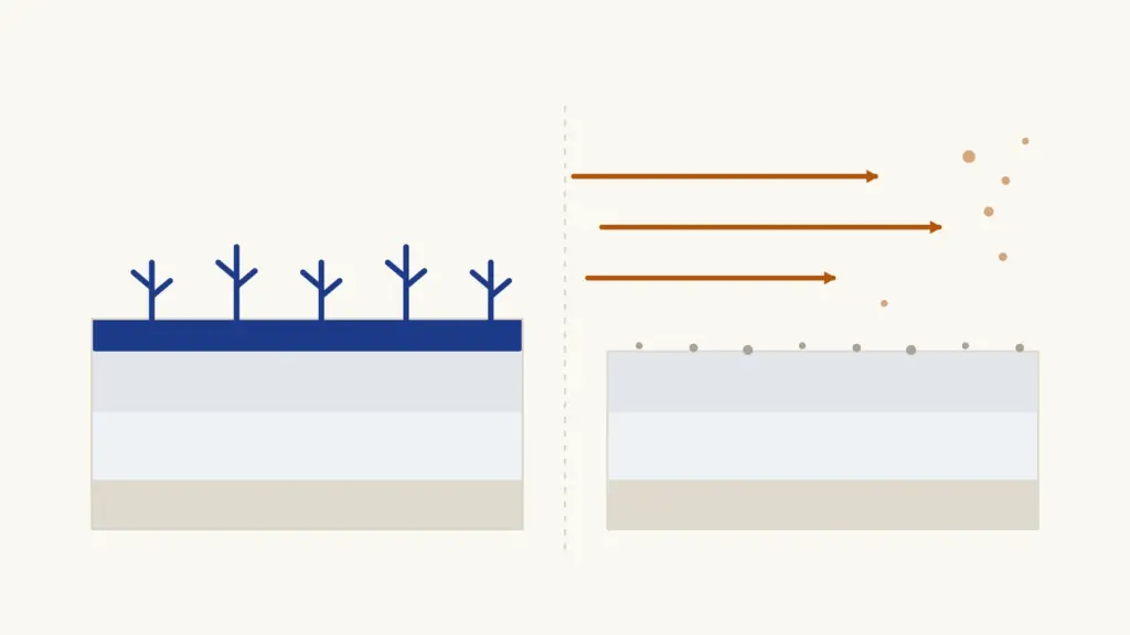
- Overgrazing beyond carrying capacity, which strips the protective vegetative crust and lets wind and water attack bare soil.
- Deforestation and removal of shelter vegetation for fuelwood, timber and cultivation.
- Unsuitable cultivation, including ploughing marginal pasture and growing water-intensive crops on dryland.
- Over-extraction of groundwater, lowering water tables and concentrating salts in the root zone.
- Waterlogging and salinity from poorly drained canal command areas, a major problem in parts of Punjab, Haryana and western UP.
- Mining and quarrying, which remove topsoil and leave overburden.
- Climatic factors: rainfall variability, prolonged drought and rising evapotranspiration under warming.
The Processes at Work
- Water erosion: sheet, rill and gully erosion, most visible in the ravine tracts of the Chambal and Yamuna.
- Wind erosion: deflation strips fine silt, clay and organic matter; saltation moves sand in low hops; migrating dunes bury cropland and canals. The landform vocabulary is covered in our note on weathering and erosion landforms.
- Salinisation and alkalinisation, where evaporation concentrates salts at the surface.
- Nutrient and organic-carbon depletion from continuous cropping without replenishment.
- Frost shattering and glacial action in cold deserts such as Ladakh and Spiti.
Consequences
- Falling yields push cultivators onto still more marginal land, which is a self-reinforcing degradation spiral.
- Siltation of canals and reservoirs, reduced groundwater recharge and shorter reservoir life.
- Loss of biodiversity and shrinkage of grazing commons, hitting pastoralists first.
- Dust storms causing respiratory illness, road and air accidents, and transboundary particulate loading.
- Distress migration from degraded rural tracts, and an estimated economic cost running to a significant share of GDP once ecosystem services are counted.
What India Is Doing
| Instrument | What it does |
|---|---|
| UNCCD commitment | India hosted COP14 in 2019 and pledged land degradation neutrality; the Delhi Declaration came out of that meeting |
| Bonn Challenge pledge | Restore 26 million hectares of degraded land by 2030 |
| Desert Development Programme | Area-based works in hot and cold desert districts |
| Integrated Watershed Management | Now under PMKSY 2.0, with ridge-to-valley treatment |
| MGNREGA | Water harvesting, afforestation and land-development works at scale |
| National Afforestation Programme and Green India Mission | Forest and tree cover restoration |
| Soil Health Cards | Nutrient management to slow chemical degradation |
Field-level control follows a well-tested sequence: shelterbelts and windbreaks, sand-dune stabilisation with species such as Prosopis and Calligonum, contour bunding and check dams, silvipasture, mulching and rotational grazing. The wider toolkit is in our guide to soil conservation.
The Honest Limits
- Land degradation neutrality targets are easy to announce and hard to verify; restoration is often counted by plantation area rather than by surviving canopy.
- Compensatory afforestation frequently replaces diverse natural systems with monoculture plantation, which restores cover but not function.
- Common grazing land is legally weak and easily reclassified as wasteland available for allotment, so pastoral users lose first.
- Engineering works fail without the vegetative component; stabilisation is a biological problem before it is a civil one.
Frequently Asked Questions
What is desertification according to the UNCCD?
The United Nations Convention to Combat Desertification defines it as land degradation in arid, semi-arid and dry sub-humid areas resulting from various factors, including climatic variations and human activities. It does not mean existing deserts physically expanding.
How much of India’s land is degraded?
ISRO’s Desertification and Land Degradation Atlas puts roughly 97.85 million hectares, about 29.7 per cent of India’s total geographical area, under degradation. Water erosion is the largest single process, followed by vegetation degradation and wind erosion.
What is the difference between desertification and land degradation?
Land degradation is the long-term loss of ecosystem function in any climatic zone. Desertification is the subset of land degradation that occurs specifically in arid, semi-arid and dry sub-humid areas. All desertification is land degradation, but not the reverse.
Which Indian states are worst affected by desertification?
Five states and union territories have more than half their own area under degradation: Rajasthan, Delhi, Gujarat, Goa and Jharkhand, with Rajasthan the worst at 68.3 per cent. By absolute contribution, nine states account for 23.79 per cent of national desertification: Rajasthan, Maharashtra, Gujarat, Karnataka, Ladakh, Jharkhand, Odisha, Madhya Pradesh and Telangana.
What is land degradation neutrality?
It is the UNCCD target of ensuring that the amount and quality of land resources needed to support ecosystem functions remains stable or increases. India committed to it at COP14, held in New Delhi in 2019, and has pledged to restore 26 million hectares by 2030 under the Bonn Challenge.
What are the main methods to control desertification?
Shelterbelts and windbreaks, sand-dune stabilisation with hardy species, contour bunding and check dams, watershed treatment on a ridge-to-valley basis, silvipasture, mulching and rotational grazing. Vegetative stabilisation matters more than engineering works alone.
Practice Questions
Prelims MCQs
1. Desertification, as defined by the UNCCD, refers to land degradation in:
- (a) All climatic zones
- (b) Humid tropical zones only
- (c) Arid, semi-arid and dry sub-humid areas
- (d) Coastal zones only
Answer: (c) Arid, semi-arid and dry sub-humid areas
2. Which organisation publishes the Desertification and Land Degradation Atlas of India?
- (a) ICAR
- (b) ISRO’s Space Applications Centre
- (c) Central Ground Water Board
- (d) Forest Survey of India
Answer: (b) ISRO’s Space Applications Centre
3. The largest single process of land degradation in India by area affected is:
- (a) Wind erosion
- (b) Water erosion
- (c) Salinity
- (d) Waterlogging
Answer: (b) Water erosion
4. UNCCD COP14, which produced the Delhi Declaration, was held in:
- (a) 2015
- (b) 2017
- (c) 2019
- (d) 2021
Answer: (c) 2019
5. Under the Bonn Challenge, India has pledged to restore how much degraded land by 2030?
- (a) 13 million hectares
- (b) 21 million hectares
- (c) 26 million hectares
- (d) 33 million hectares
Answer: (c) 26 million hectares
Mains Questions
- Discuss the role of aeolian processes in desertification and land degradation.
- “Desertification in India is a governance failure before it is a climatic one.” Critically examine.
- Distinguish between land degradation and desertification, and assess India’s progress towards land degradation neutrality.
- Examine the effectiveness of watershed development programmes in arresting land degradation in India.
- Discuss the socio-economic consequences of land degradation for pastoral and forest-dependent communities in India.
Tell Google you want more of this.
Add Anantam IAS as a preferred sourceOne tap, and this site shows up more often in your own Top Stories, AI Overviews and AI Mode. Remove it any time.