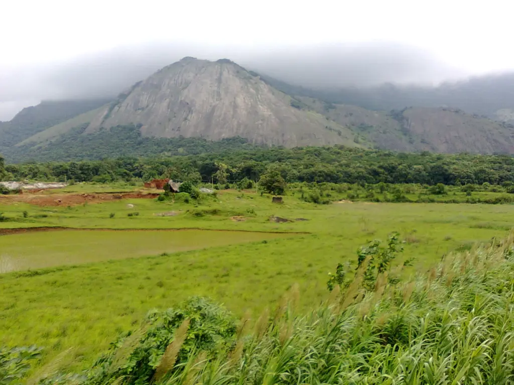
The Palghat Gap, also called the Palakkad Gap, is the widest break in the Western Ghats: a lowland corridor between the Nilgiri Hills to the north and the Anaimalai Hills to the south that joins Palakkad in Kerala with Coimbatore in Tamil Nadu. For most of their length the Ghats stand as an unbroken wall along the west coast, and the Palghat Gap is where that wall opens, so the main road and railway between the two states run through it and monsoon air crosses into Tamil Nadu through it.
Most readers picture a pass as a notch over a high ridge, and they carry one width figure from a guidebook. The Palghat Gap is neither. Its floor lies at about 140 m while the hills on both sides rise above 2,000 m, it follows a scar in the ancient crust rather than a river’s cut, and published widths run from 24 to 40 km depending on the source. This note sorts out what the sources actually say, then explains why one break in a mountain range matters so much for the climate and the wildlife of south India.
Where Is the Palghat Gap?
The Palghat Gap lies at about 11°N, astride the Kerala-Tamil Nadu border, where the Western Ghats fall away from the Nilgiri massif to a floor of about 140 m and rise again into the Anaimalai Hills. Britannica calls it a major break in the range and a major communication route between the two states. The Palakkad district administration puts it more plainly: the district opens Kerala to the rest of the country through the gap. The note on the Western Ghats sets the whole range in context; these are the facts about this one opening.
| Fact | Detail |
|---|---|
| Also called | Palakkad Gap; the Palghat pass in Tamil Nadu’s wind-energy records |
| Location | About 11°N, on the Kerala-Tamil Nadu border between Palakkad and Coimbatore districts |
| Flanking hills | Nilgiri Hills to the north, Anaimalai Hills to the south, both above 2,000 m (Rajendran, 2025) |
| Width | About 32 km (Britannica); 32 to 40 km (Palakkad district); 40 km (Robin et al., 2010; Vidya et al., 2005); 24 to 30 km (Rajendran, 2025) |
| Floor elevation | About 140 m (Rajendran, 2025) |
| Geology | Lies on the Palghat-Cauvery shear zone; its high-pressure rocks dated to about 535 million years ago (Collins et al., 2007) |
| River | The Bharathappuzha, draining west to the Arabian Sea at Ponnani |
| Transport | Highways and rail lines linking Palakkad with Coimbatore and Pollachi; the Pattambi-Podanur rail section opened on 14 April 1862 |
| Wind | One of Tamil Nadu’s four wind passes, feeding Coimbatore, Tirupur and Erode districts (Tamil Nadu ENVIS Centre) |
Four sources give four widths, and none of them is careless. A gap has no sharp walls. The hills shelve down into foothills, so where a writer draws the edge decides the number. That’s an inference from the spread, not something the sources state, but it explains why a genetics paper, an encyclopedia and a district website can all be right at once.
So which figure goes into an answer? It is wise to write 32 to 40 km, the range the Kerala government’s own district page uses, and to add that estimates vary. The ranking doesn’t vary. Robin and colleagues measured the Palghat Gap as the widest opening in the range and the Shencottah Gap further south as the narrowest, only about 7.5 km across.
The elevation rests on one source: about 140 m, from a 2025 commentary by the geologist C.P. Rajendran of the National Institute of Advanced Studies, Bengaluru. Treat it as the approximate height of the gap’s floor; a gap has no summit the way a Himalayan pass does.
How Did the Palghat Gap Form?
The Palghat Gap sits on the Palghat-Cauvery shear zone, a belt of intensely deformed ancient rock that runs roughly east-west across south India. It isn’t a valley carved through the Ghats by a river. It’s the place where the range crosses a deep scar in the crust.
A shear zone is a band where two masses of rock slid past each other deep underground, under enough heat and pressure that the rock flowed instead of snapping. Push the top half of a deck of cards sideways and the cards in the middle smear into a slanted band. The analogy holds for the sliding and breaks on everything else. Cards slide on clean surfaces and stay the same cards, while rock in a shear zone recrystallizes into new minerals, and those new minerals are exactly what lets geologists date the movement.
Geologists care about this belt because it marks a seam between two very different pieces of the peninsula:
- To the north lies the Dharwar craton, the old, stable core of south India under most of Karnataka. A craton is a block of continental crust that has stayed intact since the Archean, more than 2.5 billion years ago.
- To the south lies the Southern Granulite Terrain, rocks under Tamil Nadu and Kerala that were baked deep in the crust into granulites, a family of high-temperature metamorphic rocks.
How old the seam is, and exactly where it runs, are still argued over. Three pieces of work show the range of views:
- Collins and colleagues (Terra Nova, 2007) dated zircon and monazite crystals from the zone’s high-pressure rocks to about 535 million years ago, in the Cambrian. They read the zone as the suture of the Mozambique Ocean, the sea that closed as Gondwana assembled, and as the continuation of the Betsimisaraka suture in Madagascar. A suture is the seam left where two plates were welded together.
- Das and Rai (Precambrian Research, 2019) note that the boundary between the Dharwar craton and the Southern Granulite Terrain has been debated for about 75 years, and that the Palghat-Cauvery zone is widely taken as the contact. Their seismic image from 80 stations found a thick layer of dense lower crust under the southern craton that carries on south past the shear zone, which suggests the craton reaches further south than the maps show.
- Rajendran’s 2025 commentary sums up the older alternatives: plate interactions between 2.5 and 1 billion years ago, and a minority idea of an asteroid crater about 100 km wide and 1.5 billion years old, which hasn’t gained much support.
Rajendran also flags a puzzle. The crust under Palghat is 36 to 38 km thick, against more than 50 km beneath the Nilgiris, so the gap is a place where the crust is thin as well as low, which he links to subsidence. The zone isn’t geologically silent either. He records a magnitude 4.3 earthquake near Wadakkanchery on 2 December 1994 and an event close to magnitude 5.5 on 8 February 1900.
Hold on to the settled part: the gap lines up with an ancient shear zone, and the rocks on either side have different histories. The date and the exact boundary are where the research is still moving. The note on the Peninsular Block and its landforms gives the wider structure these pieces belong to.
How Does the Palghat Gap Affect the Monsoon and Winds?
The Palghat Gap lets air through a range that otherwise blocks it. Britannica notes that both the wet southwest monsoon and storms from the Bay of Bengal cross the Ghats through the opening, so the gap works in both directions.
Along most of the Ghats, the southwest monsoon rises up the western slopes, cools and drops its rain on the Kerala side. The plateau behind is left in a rain shadow, a belt that stays drier because the rain has already fallen before the air arrives. The southwest monsoon note covers that mechanism in full.
Coimbatore sits in that rain shadow, the district administration says, yet it enjoys a pleasant climate aided by the breeze that flows through the gap. Rajendran describes the gap as a conduit for moisture-laden monsoon winds into Tamil Nadu that moderates the summer heat. Picture the Ghats as a long wall with one wide doorway. The doorway explains the breeze. The analogy breaks on rain, and this is the confusion worth clearing up: the gap softens Coimbatore’s weather, but it doesn’t give Coimbatore Kerala’s rainfall, and the district still counts itself in the rain shadow.
A Funnel for Wind Power
The same opening makes the gap one of south India’s wind-power zones. The Tamil Nadu government’s ENVIS Centre, run by its Department of Environment, lists four wind passes in the state:
- Palghat pass, covering Coimbatore, Tirupur and Erode districts.
- Cumbum pass, covering Theni and Dindigul.
- Sengottah pass, covering Tirunelveli and Thoothukudi.
- Aralvaimozhi pass, covering Kanyakumari and Tirunelveli, where Muppandal has the state’s largest installation of windmills.
On the Palghat pass, the ENVIS record says the gap funnels westerly winds onto Coimbatore and Tirupur districts, with large wind farms in and around Udumalaipettai and Kadathur. The national wind agency took the gap seriously early. The Centre for Wind Energy Technology, now the National Institute of Wind Energy, bought a SODAR, an instrument that uses sound pulses to profile the wind at height, for a project to study the flow pattern in the Palghat gap, according to its April-June 2005 bulletin.
Kerala went to the same spot. The first non-conventional energy project of the Kerala State Electricity Board was the wind farm at Kanjikode in Palakkad district: nine turbines of 225 kW each, 2.025 MW in all, commissioned on 18 May 1995.
Why Do Roads and Railways Run Through the Palghat Gap?
Because it’s the one wide, low crossing of the southern Ghats. Anything that needs a gentle gradient between the Kerala coast and the Tamil Nadu plains is drawn to it, a railway most of all. Britannica notes the highways and rail lines through the gap that link Palakkad with Coimbatore and Pollachi.
The railway came early. Southern Railway’s history of its Palakkad division records the Pattambi-Podanur section, 105 km long, opening on 14 April 1862, about a year after the first line in present-day Kerala opened between Beypore and Tirur on 12 March 1861. Podanur is on the Coimbatore side and Pattambi on the Kerala side, so that 1862 section is the line through the gap. Today the Palakkad division runs from Podanur in the east to Mangalore via Shoranur, and its Palakkad Town-Pollachi line was converted to broad gauge in March 2015.
The gap also carries the river that drains it. The Bharathappuzha, also written Bharathapuzha and called the Ponnani river or the Nila, rises in the Ghats northeast of Palakkad in Britannica’s account and flows west across the plain to the Arabian Sea at Ponnani. The plain it waters is farm country, and the district administration calls Palakkad one of the main granaries of Kerala.
Why Is the Palghat Gap a Barrier for Wildlife?
For species that live only in the cool, high forests of the Ghats, a warm lowland 30 to 40 km across is as hard to cross as a strip of sea. Over long spans of time, populations on either side stop mixing and their genes drift apart. Four genetic studies show this at the Palghat Gap:
- White-bellied shortwing. Robin, Sinha and Ramakrishnan (PLoS ONE, 2010) found populations of this small bird of the high shola forests to be reciprocally monophyletic across the gap, meaning each side forms its own separate branch of the family tree. They argued the two should be treated as different species.
- Montane birds as a community. Robin and colleagues (Proceedings of the Royal Society B, 2015) sampled 23 bird species; 10 showed their oldest splits across the Palghat Gap, which they call the widest and deepest valley in the range. Most of those splits date to the Pleistocene.
- Asian elephant. Vidya and colleagues (Heredity, 2005) found the Nilgiri population, the world’s single largest population of Asian elephants, genetically distinct from the Anaimalai and Periyar populations south of the gap.
- Nilgiri tahr. Joshi and colleagues (Mitochondrial DNA Part B, 2018) found two diverged populations of the Nilgiri tahr north and south of the gap, a shallow split they place in the Pleistocene.
A barrier isn’t a wall, and the same studies say so. In the 2015 bird study a majority of the 23 species showed no split at any valley, and the tahr’s divergence is shallow. Elephants still use the forests on the gap’s floor, as the railway section below shows. The gap filters movement over thousands of years; it doesn’t stop an animal walking across in a season.
The practical lesson for conservation follows from the genetics. The southern Ghats don’t hold one continuous population of each species. The Asian elephant shows it: numerous in the Nilgiris, it survives south of the gap as smaller, genetically separate populations, and losses there can’t simply be made up from the north.
The same pattern repeats further south. Robin’s 2010 study treats the Palghat and Shencottah gaps as the two older gaps of the range, both lying along shear zones that were active about 500 million years ago, and the narrow Shencottah Gap separates the Cardamom Hills from the ranges to their south.
The Palghat Gap Today
No single law protects the Palghat Gap as a unit. Its floor is towns, paddy fields and industry, while the forests on its flanks sit in protected areas and in the long-running Western Ghats Ecologically Sensitive Area process. The recent record, with its dates, runs like this.
Elephants and the Railway
Two railway tracks cross the Solakarai beat and Bolampatti Block-I reserved forests of Tamil Nadu’s Madukkarai range, where they border Kerala’s forests along the Walayar river. In February 2024 the Tamil Nadu forest department inaugurated an AI-based early-warning system there, with 12 towers carrying thermal and ordinary cameras that alert forest staff and loco pilots when elephants approach the track. Down To Earth reported in March 2025 that 11 elephants had died in train collisions in the range since 2008. It also reported that the state had allocated Rs 7.24 crore, and that a year after launch officials counted zero elephant deaths, 5,011 alerts and 2,500 safe crossings.
Industry on the Corridor
On 28 August 2024 the Cabinet Committee on Economic Affairs approved 12 industrial nodes under the National Industrial Corridor Development Programme, and Palakkad in Kerala is one of them, according to the PIB release. The corridor logic hasn’t changed since 1862.
Heat and Wind
Palakkad, on the Kerala side of the gap, reached 41.8 °C on 27 April 2024, and the IMD declared the district heatwave-hit. On the Tamil Nadu side, the Palghat pass is one of the state’s wind passes, and the repowering challenge facing India’s older wind farms applies to it as well.
Protection on the Flanks
The hills that frame the gap carry protected forest on both sides, with Silent Valley on the Nilgiri side and Parambikulam on the Anaimalai side. Both fall in Palakkad district. The wider legal cover has now run through six drafts: the Environment Ministry’s sixth draft notification proposes declaring over 56,800 sq km of the Ghats across six states an Ecologically Sensitive Area, after earlier drafts lapsed.
How to Study the Palghat Gap for Exams
The Palghat Gap sits in GS Paper I twice: under the physiography of India, as the widest break in the Western Ghats, and under climate, as the reason monsoon air reaches Coimbatore. It turns up again in resource geography, because wind farms crowd into passes, and in GS Paper III’s environment topics, because it splits the hotspot’s populations. The note on the Nilgiri Hills covers the northern wall of the gap in detail.
Mains doesn’t name the gap; it asks about the processes the gap illustrates. Mains 2022 GS Paper I asked: “Examine the potential of wind energy in India and explain the reasons for their limited spatial spread.” The Palghat pass is the example that answers the second half of that question: turbines cluster where terrain funnels the wind, and that happens in only a few places. Indian geography accounts for 70 of the 1,403 questions in the Prelims question bank, and a location like this one is the kind of fact map questions reward.
These are the facts to carry into revision:
- Location: between the Nilgiri Hills (north) and the Anaimalai Hills (south), joining Palakkad in Kerala with Coimbatore in Tamil Nadu, at about 11°N.
- Size: about 32 km wide (Britannica), 32 to 40 km (Palakkad district), 40 km (genetic studies); floor about 140 m.
- Geology: the Palghat-Cauvery shear zone, with high-pressure rocks dated to about 535 million years ago; widely taken as the Dharwar craton-Southern Granulite Terrain contact, a boundary still debated.
- Climate: lets southwest monsoon air and Bay of Bengal storms cross the Ghats; Coimbatore stays in the rain shadow but gets the breeze.
- Wind: one of Tamil Nadu’s four wind passes (Coimbatore, Tirupur, Erode); KSEB’s Kanjikode wind farm, commissioned in 1995.
- Transport: the Pattambi-Podanur rail section through the gap opened on 14 April 1862.
- Ecology: genetic splits across the gap in the white-bellied shortwing, the Asian elephant and the Nilgiri tahr.
Four confusions come up again and again:
- Palghat and Palakkad. Same place. Palakkad is the official name of the town and district; the older spelling survives in the gap’s name.
- Palghat Gap and Shencottah Gap. Palghat is the wide northern break at about 11°N. Shencottah is the narrow southern one, about 7.5 km at 9°N, linking Sengottai in Tamil Nadu with Punalur in Kerala.
- Gap and pass. The Thal and Bhor ghats of the northern Ghats are road passes that climb the escarpment. The Palghat Gap is a lowland where the range itself is interrupted.
- Breeze and rain. The gap brings wind and some moisture to Coimbatore, not Kerala’s rainfall.
The breaks and passes of the southern Ghats are easiest to keep apart side by side:
| Break or pass | Where | Size in the sources | Tamil Nadu wind districts (ENVIS) |
|---|---|---|---|
| Palghat Gap | Nilgiri and Anaimalai hills; Palakkad to Coimbatore | 32 to 40 km; the widest (Robin et al., 2010) | Coimbatore, Tirupur, Erode |
| Shencottah (Sengottah) Gap | Sengottai (Tamil Nadu) to Punalur (Kerala) | About 7.5 km; the narrowest (Robin et al., 2010) | Tirunelveli, Thoothukudi |
| Cumbum pass | Tamil Nadu to central Kerala | Not given in these sources | Theni, Dindigul |
| Aralvaimozhi pass | Southern end of the Ghats | Not given in these sources | Kanyakumari, Tirunelveli; Muppandal wind farms |
The Palghat Gap is a small mark on the map that carries three syllabus themes at once: structure, climate and biogeography. Learn it as a working example rather than a single fact, and it gives any answer on the Western Ghats one concrete place to stand on.
Frequently Asked Questions
Where is the Palghat Gap located?
The Palghat Gap lies on the Kerala-Tamil Nadu border at about 11 degrees north, between the Nilgiri Hills to the north and the Anaimalai Hills to the south. It joins Palakkad in Kerala with Coimbatore in Tamil Nadu and is the widest break in the Western Ghats.
What is the width of the Palghat Gap?
Sources differ. Britannica gives about 32 km, the Palakkad district administration 32 to 40 km, the genetic studies 40 km and a 2025 commentary by the geologist C.P. Rajendran 24 to 30 km. The safest answer is 32 to 40 km, with a note that estimates vary, and a floor elevation of about 140 m.
Is the Palghat Gap the same as the Palakkad Gap?
Yes. Palakkad is the official name of the town and district that used to be spelled Palghat, and both names are used for the gap. Tamil Nadu’s wind-energy records call it the Palghat pass.
How was the Palghat Gap formed?
The gap lies on the Palghat-Cauvery shear zone, a belt of intensely deformed ancient rock widely taken as the boundary between the Dharwar craton and the Southern Granulite Terrain. Collins and colleagues dated its high-pressure rocks to about 535 million years ago, though the age and the exact boundary are still debated.
Why is the Palghat Gap important for Tamil Nadu’s climate?
It is the one wide opening through which southwest monsoon air crosses the Western Ghats into Tamil Nadu. Coimbatore still lies in the rain shadow, but the breeze through the gap gives it a milder climate than the rest of the leeward side.
Why are there so many wind farms near the Palghat Gap?
The gap funnels westerly winds onto Coimbatore and Tirupur districts, so Tamil Nadu counts it as one of its four wind passes, with large farms around Udumalaipettai. On the Kerala side, the state electricity board commissioned its first wind farm at Kanjikode in Palakkad district in 1995.
Which animals are genetically separated by the Palghat Gap?
Genetic studies have found splits across the gap in the white-bellied shortwing, the Asian elephant and the Nilgiri tahr. A 2015 study of 23 montane bird species found the oldest divergences of 10 of them at the Palghat Gap.
Which river and railway pass through the Palghat Gap?
The Bharathappuzha drains the gap westward to the Arabian Sea at Ponnani. The railway through the gap dates to the Pattambi-Podanur section, opened on 14 April 1862, and highways and rail lines now link Palakkad with Coimbatore and Pollachi.
Practice Questions
Prelims
1. The Palghat Gap separates which of the following pairs of hill ranges?
- (a) Nilgiri Hills and Anaimalai Hills
- (b) Anaimalai Hills and Cardamom Hills
- (c) Nilgiri Hills and Biligirirangan Hills
- (d) Cardamom Hills and Agasthyamalai Hills
Answer: (a) The gap lies between the Nilgiri Hills to the north and the Anaimalai Hills to the south.
2. Consider the following statements about the Palghat Gap: 1. It lies on the Palghat-Cauvery shear zone. 2. High-pressure metamorphism along this shear zone has been dated to about 535 million years ago. 3. It is the narrowest break in the Western Ghats. Which of the statements given above is/are correct?
- (a) 1 only
- (b) 1 and 2 only
- (c) 2 and 3 only
- (d) 1, 2 and 3
Answer: (b) Statements 1 and 2 are correct; the Palghat Gap is the widest break, and the Shencottah Gap is the narrowest.
3. Consider the following statements: 1. The Palghat pass is one of the wind passes of Tamil Nadu. 2. The Muppandal wind farms lie along the Palghat pass. Which of the statements given above is/are correct?
- (a) 1 only
- (b) 2 only
- (c) Both 1 and 2
- (d) Neither 1 nor 2
Answer: (a) Muppandal lies near the Aralvaimozhi pass in Kanyakumari district, not in the Palghat pass.
4. Genetic studies have reported divergence between populations north and south of the Palghat Gap in which of the following? 1. Asian elephant 2. Nilgiri tahr 3. White-bellied shortwing. Select the correct answer using the code given below.
- (a) 1 and 2 only
- (b) 2 and 3 only
- (c) 1 and 3 only
- (d) 1, 2 and 3
Answer: (d) Vidya et al. (2005), Joshi et al. (2018) and Robin et al. (2010) reported splits in all three.
5. Coimbatore lies in the rain shadow of the Western Ghats yet has a relatively mild climate. Which one of the following best explains this?
- (a) Its altitude of over 1,500 m
- (b) Monsoon air entering through the Palghat Gap
- (c) Its location on the Coromandel coast
- (d) Sea breeze from the Gulf of Mannar
Answer: (b) The Coimbatore district administration credits the breeze through the Palakkad Gap for the city’s pleasant climate.
Mains
- Briefly mention the alignment of major mountain ranges of the world and explain their impact on local weather conditions, with examples. (15 marks, 250 words) Previous year: Mains 2021, GS Paper I.
- The Palghat Gap is a narrow feature with wide consequences. Discuss its influence on the climate, economy and connectivity of Kerala and Tamil Nadu. (15 marks, 250 words)
- How do gaps in the Western Ghats shape the genetic structure of montane species? Illustrate with evidence from the Palghat Gap. (10 marks, 150 words)
- The Palghat-Cauvery shear zone has been described both as a continental suture and as a craton boundary. Explain these terms and why its age and extent are still debated. (10 marks, 150 words)
- Linear infrastructure through wildlife habitat is a recurring source of conflict. Evaluate technology-based mitigation such as AI early-warning systems, with reference to the railway through the Palghat Gap. (15 marks, 250 words)
Tell Google you want more of this.
Add Anantam IAS as a preferred sourceOne tap, and this site shows up more often in your own Top Stories, AI Overviews and AI Mode. Remove it any time.