


Disclosure: this guide contains Amazon affiliate links. As an Amazon Associate, Anantam IAS earns from qualifying purchases — at no extra cost to you.
The Subarnarekha river is a small but hydrologically and economically important peninsular river of eastern India, flowing across Jharkhand, West Bengal, and Odisha before emptying into the Bay of Bengal. Its name, meaning "streak of gold," is traced to the fine gold particles historically panned from its bed near Piska village. Rising in the Chhotanagpur plateau and falling over spectacular escarpments such as Hundru Falls, the river supports the industrial corridor around Jamshedpur and the fertile alluvial plains of Balasore. For UPSC, the Subarnarekha is a key example of a small east-flowing peninsular river.
Origin and Basic Profile
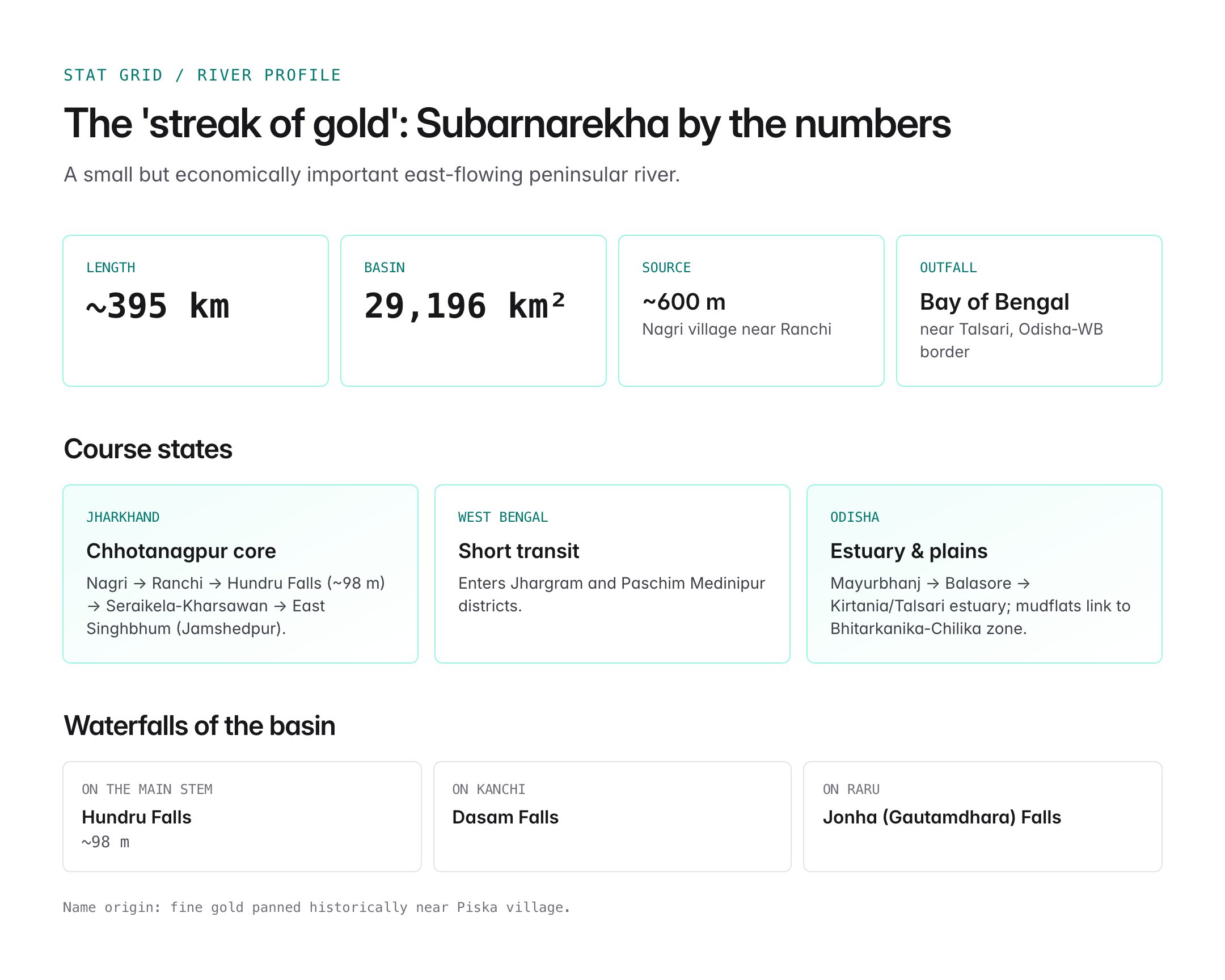
The Subarnarekha originates near Nagri village, close to Ranchi on the Chhotanagpur plateau in Jharkhand, at an altitude of about 600 metres.
- Total length: approximately 395 kilometres.
- Basin area: around 29,196 square kilometres, spread mostly across Jharkhand, with portions in Odisha and West Bengal.
- It is one of the smaller east-flowing peninsular rivers, along with the Baitarani and Brahmani.
- It flows broadly south-eastwards to meet the Bay of Bengal near Talsari, close to the Odisha-West Bengal border.
The river is entirely rain-fed and shows marked seasonal variation, with most of its flow concentrated in the south-west monsoon months.
Course of the River

Oxford Student Atlas for India — 7th Edition
- 160 pages, Oxford University Press, the current edition
- India-focused thematic maps: physical, political, rivers, climate, soils, vegetation, plus world maps
- Made for UPSC and state PSC map work; slim enough to stay open beside the textbook
In Jharkhand
- Rises near Nagri and flows past Ranchi.
- Forms the spectacular Hundru Falls (~98 m) where the river plunges over a resistant escarpment.
- Other significant waterfalls in the basin include Dasam Falls on the Kanchi tributary and Jonha (Gautamdhara) Falls on the Raru.
- Flows through Seraikela-Kharsawan and East Singhbhum, supporting the industrial complex at Jamshedpur (Tatanagar).
In West Bengal
- Enters Jhargram and Paschim Medinipur districts.
- Flows briefly through southern West Bengal before moving into Odisha.
In Odisha
- Enters Mayurbhanj and Balasore districts.
- Meets the Bay of Bengal near Kirtania/Talsari, forming a small estuary and mudflats that connect ecologically to Bhitarkanika and Chilika biogeographic zones further south.
Tributaries
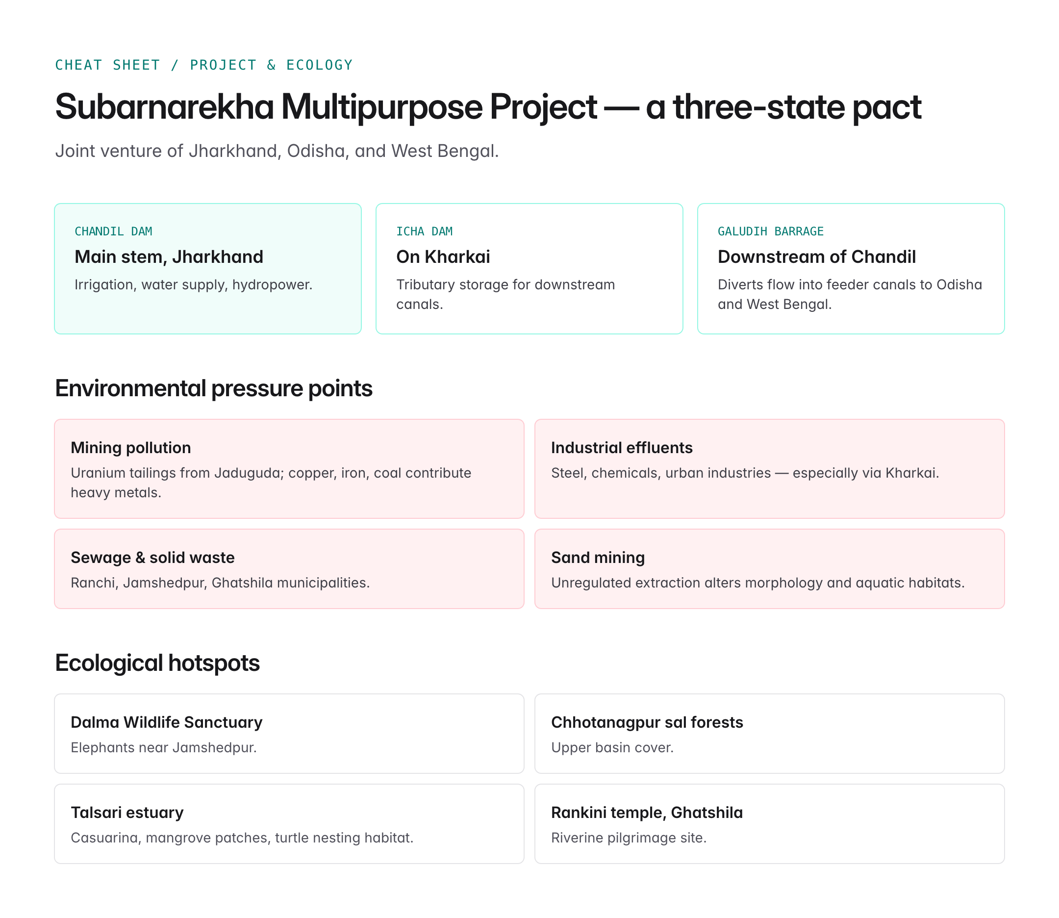
| Tributary | Bank | Notes |
|---|---|---|
| Kharkai | Right | Joins at Domuhani in Jamshedpur |
| Kanchi | Left | Forms Dasam Falls |
| Raru | Left | Forms Jonha/Gautamdhara Falls |
| Karkari | Left | Drains parts of Ranchi plateau |
| Sankh (minor) | — | Seasonal contribution |
The Kharkai confluence at Domuhani is a notable landmark inside Jamshedpur and central to the city's water supply and flood behaviour.
Subarnarekha Multipurpose Project
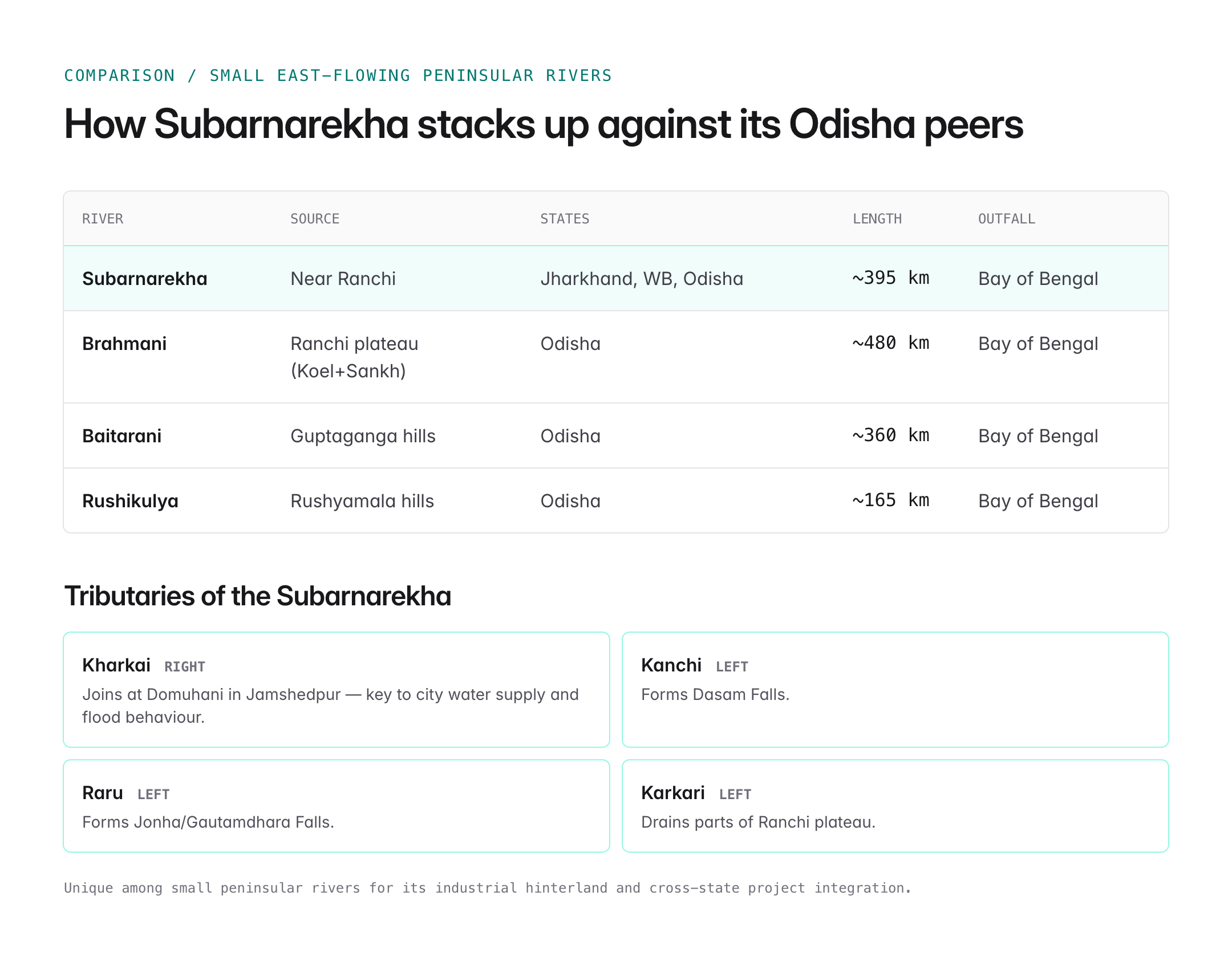
The river is harnessed through a major inter-state project.
- Subarnarekha Multipurpose Project (SMP): A joint venture of Jharkhand, Odisha, and West Bengal.
- Primary components include:
- Chandil Dam on the main Subarnarekha in Jharkhand, providing irrigation, water supply, and hydropower.
- Icha Dam on the Kharkai tributary.
- Galudih Barrage downstream of Chandil.
- Feeder canals serving Odisha and West Bengal.
- Designed to irrigate several lakh hectares across the three states and supply water to Jamshedpur's industrial complex.
- The project has faced long delays due to land acquisition, rehabilitation concerns, and inter-state coordination issues.
In addition, several minor irrigation schemes and urban water-supply intakes depend on the river, especially for Ranchi, Jamshedpur, and Ghatshila.
Ecology and Environment
The Subarnarekha basin is ecologically significant.
- Drains portions of Dalma Wildlife Sanctuary near Jamshedpur, home to elephants.
- Upper reaches pass through the Chhotanagpur plateau forests with sal dominance.
- The estuarine reach near Talsari hosts casuarina plantations, mangrove patches, and turtle nesting habitats.
- Migratory waterbirds frequent the lower basin and Balasore coast.
However, the river faces serious environmental pressures.
- Mining pollution: Uranium tailings from Jaduguda mines, as well as copper, iron, and coal mining in the basin, contribute heavy metals.
- Industrial effluents: Steel, chemicals, and urban industries discharge into tributaries, particularly the Kharkai.
- Sewage and solid waste: From Ranchi, Jamshedpur, and Ghatshila municipalities.
- Sand mining: Unregulated extraction affects morphology and aquatic habitats.
- Seasonal flows: The river's rain-fed nature makes it vulnerable to erratic monsoons and drought.
Studies by the Central Pollution Control Board (CPCB) have periodically flagged stretches of the Subarnarekha as polluted, requiring action plans under the Namami Gange and National River Conservation Plan frameworks.
Economic and Historical Importance
- Gold panning: Traditionally, fine gold was washed from the upper Subarnarekha near Piska and Ranchi. Although not commercially viable now, artisanal panning persists in small pockets.
- Industrial base: The river and its tributaries underpin the Jamshedpur steel city, one of India's earliest planned industrial hubs, and the Bokaro-Jamshedpur industrial corridor.
- Mining economy: Iron ore, copper, coal, and uranium mining in the basin contributes to India's strategic minerals supply.
- Agriculture: Rice, maize, pulses, and oilseeds are grown along the valley, especially in the alluvial reaches of Balasore.
- Cultural importance: Several pilgrimage sites, including Jonha Falls and the Rankini temple near Ghatshila, are associated with the river.
Comparison with Other Small Peninsular Rivers
| River | Source | States | Length (km) | Outfall |
|---|---|---|---|---|
| Subarnarekha | Near Ranchi | Jharkhand, WB, Odisha | ~395 | Bay of Bengal |
| Brahmani | Ranchi plateau (Koel+Sankh) | Odisha | ~480 | Bay of Bengal |
| Baitarani | Guptaganga hills | Odisha | ~360 | Bay of Bengal |
| Rushikulya | Rushyamala hills | Odisha | ~165 | Bay of Bengal |
The Subarnarekha is unique for its industrial hinterland and cross-state project integration.
UPSC Relevance
Prelims focus:
- Origin near Nagri in Jharkhand; meeting the Bay of Bengal near Talsari.
- Key tributaries: Kharkai, Kanchi, Raru.
- Famous waterfalls: Hundru, Dasam, Jonha (Gautamdhara).
- Subarnarekha Multipurpose Project with Chandil, Icha, and Galudih structures.
- States covered: Jharkhand, West Bengal, Odisha.
Mains GS-I and GS-III angles:
- Drainage characteristics of peninsular east-flowing rivers.
- Role of rivers in industrial location and regional development (Jamshedpur case).
- Environmental concerns: mining pollution, heavy metals, and river health.
- Inter-state river cooperation through joint projects.
Sample PYQ angle: "Account for variations in oceanic salinity and discuss its multi-dimensional effects" or questions on India's drainage systems and resource-rich river basins. Subarnarekha's combination of mineral wealth, industrial usage, and inter-state institutional arrangements provides ready examples for GS-I physical geography and GS-III resource management answers.
Tell Google you want more of this.
Add Anantam IAS as a preferred sourceOne tap, and this site shows up more often in your own Top Stories, AI Overviews and AI Mode. Remove it any time.






