Why in News?
On 9 September 2026, the Department of Land Resources announced that DILRMP 3.0 operational guidelines would be launched on 10 September at 6:30 PM, outlining a proposed integrated Land Stack.
- DILRMP 3.0 is presented as a Central Sector Scheme; its scheduled evening launch remains upcoming at morning publication.
- The proposed GIS-enabled Land Stack would connect maps, ownership details, property registration and court cases.
- Bhu-Aadhaar or ULPIN would identify land parcels through a 14-digit identifier; it is a parcel reference, not an ownership guarantee.
- Planned interventions include georeferenced cadastral maps, paperless registration and integrated revenue court case management.
- Fragmented records can make citizens reconcile different descriptions of the same property across offices.
- Land governance depends on matching a physical parcel with recorded rights, transactions and disputes, while preserving correction and hearing procedures.
UPSC Relevance
Prelims Relevance
- DILRMP: Digital India Land Records Modernization Programme.
- DoLR: Department of Land Resources, Ministry of Rural Development.
- Cadastral map: a map showing individual land parcels and their boundaries.
- ULPIN: Unique Land Parcel Identification Number, also called Bhu-Aadhaar.
- RCCMS: Revenue Court Case Management System.
Mains Relevance
GS Paper 2
- Governance: coordinated land services, accessible corrections and accountable information sharing.
GS Paper 3
- Land reforms: reliable parcel information, transaction costs and protection against disputed claims.
Essay
- Trust in public records requires both accurate information and a fair opportunity to contest it.
Background and Context
Start with the parcel, not the screen
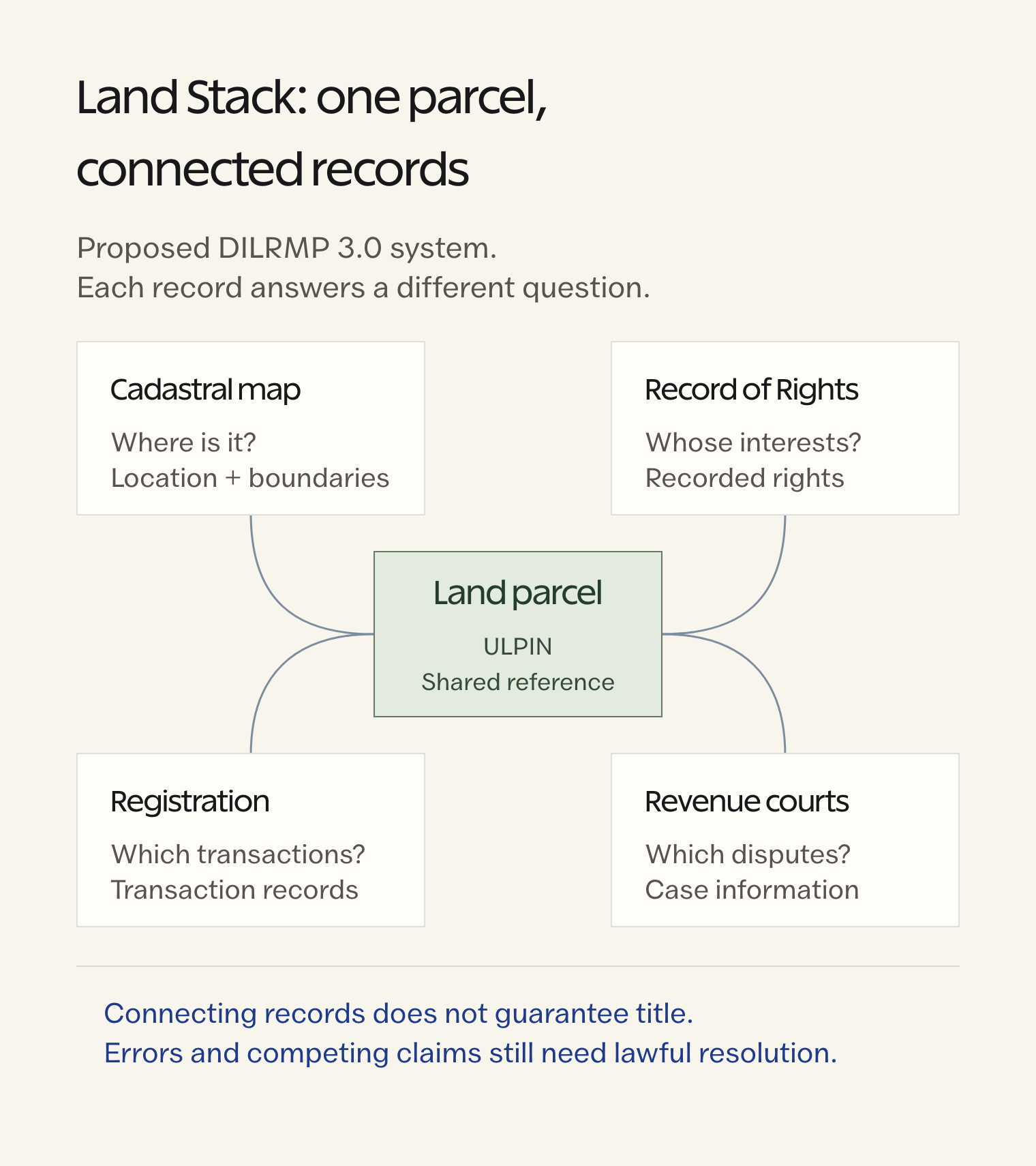
A Land Stack becomes useful when different records reliably refer to the same piece of land, despite describing different aspects of it.
- A physical parcel is a bounded piece of land. Field bunds are visible features, but they alone cannot establish the surveyed boundary, recorded owner or legal title.
- A cadastral map describes parcel boundaries and location relative to neighbouring parcels. Georeferencing connects that mapped space to geographic coordinates, helping officials compare the map with land on the ground.
- A Record of Rights supplies textual information about recorded interests in land. Its entries and the parcel map must correspond; a digitised name without the correct spatial reference can misidentify the property.
- The proposed ULPIN provides a shared reference for a parcel across connected systems. Identification helps link information, but does not independently verify every entry attached to that reference or settle competing ownership claims.
- GIS enables spatial information to be examined alongside associated records. The key administrative gain is locating which parcel a transaction or dispute concerns, rather than merely displaying another scanned document online.

Connect maps, transactions and disputes
The proposed architecture links complementary records around a parcel; it does not turn every record into the same kind of evidence.
- The registration system holds records of registered transactions. Linking these with land records can help officials identify relevant changes, while recognising that registration information and the updated revenue entry serve different purposes.
- Revenue records and survey information answer different questions about a property. Integration should expose discrepancies between a parcel description and its recorded interests instead of silently treating one database as universally correct.
- An integrated revenue court case system could show whether a linked parcel is involved in recorded proceedings. Case visibility supports informed decisions; it cannot itself decide the merits of the dispute.
- The Department of Land Resources describes court linkage as providing authentic first-hand land and registration information. Its value lies in supporting judicial examination, while the competent court still evaluates the evidence.
- Secure APIs would allow authorised systems to exchange information. A sound design should retain the responsible office, update time and source record, allowing a user to trace why a parcel entry changed.
Digital identity is not guaranteed title
The most important exam distinction is between improving access to evidence and changing the legal certainty that the evidence provides.
- India’s land-record modernisation seeks to move towards conclusive titling. That policy objective must not be confused with a completed legal transition merely because a parcel acquires a digital identifier or online record.
- Revenue entries do not by themselves confer title, as the Supreme Court has reiterated. A computerised entry cannot gain stronger legal force simply through scanning, database linkage or display on an official portal.
- Legacy errors can spread when connected systems reuse an incorrect boundary or name. A useful safeguard is a documented correction process that checks supporting records and identifies which office must resolve the inconsistency.
- Exclusion risks arise if people cannot inspect entries, submit objections or obtain assisted service. Digitisation should make such remedies easier to use, especially where literacy, connectivity or documentation gaps obstruct access.
- The announcement establishes proposed interventions, not demonstrated nationwide outcomes. Evaluate implementation through accurate parcel matching, completed corrections and accessible dispute information; fewer visits or faster disposal remain expected benefits until supported by evidence.
Way Forward
Make every linked entry contestable
- Reconcile before linking: compare parcel maps, textual records and registration descriptions; flag mismatches for accountable review.
- Preserve due process: provide notice, accessible objections and assisted correction channels before disputed changes become widely reused.
- Measure service quality: track correction completion and retrieval of relevant case information, alongside digitisation progress.
- Limit access: use permissions and audit trails to protect personal information while enabling legitimate public services.
Conclusion
- DILRMP 3.0 proposes a move from separate digital documents towards connected parcel information. Its distinctive promise is making maps, recorded interests, transactions and disputes intelligible together for citizens and institutions.
- Use this distinction in answers: interoperability improves access to evidence; reliable title also requires lawful records and dispute resolution. Judge the reform by the accuracy and contestability of the information it connects.
UPSC Practice Questions
Prelims MCQ 1
With reference to the proposed Land Stack, consider the following statements:
- ULPIN identifies a land parcel.
- Georeferencing connects mapped land information to geographic coordinates.
- An integrated case-management system automatically adjudicates disputes over title.
How many of the above statements are correct?
(a) Only one (b) Only two (c) All three (d) None
Answer: (b) Only two
Explanation:
The first two statements are correct. Case management links proceedings and information; adjudication remains with the competent authority.
Prelims MCQ 2
Which distinction best explains the purpose of connecting land records with registration and court information?
(a) All connected records become conclusive title certificates. (b) Physical boundaries become irrelevant once records are online. (c) Different records provide complementary information about the same parcel. (d) A pending court case automatically cancels every registered transaction.
Answer: (c) Different records provide complementary information about the same parcel.
Explanation:
Maps, textual records, registered transactions and court proceedings describe different aspects of a parcel. Integration supports examination without making their legal roles identical.
UPSC Mains Questions
- Explain how a parcel-centred Land Stack could improve land governance. What safeguards are necessary to prevent digitisation from reproducing errors?
- Distinguish digital land-record integration from conclusive titling. Discuss why access to remedies remains essential in land administration.
Sources: PIB, Ministry of Rural Development and Department of Land Resources.
Frequently Asked Questions
What is the proposed DILRMP 3.0 Land Stack?
It is a proposed interoperable land-information system connecting maps, recorded ownership details, registration information and court cases. The aim is to make information about the same parcel easier to retrieve and compare.
Had the DILRMP 3.0 guidelines been launched at this note’s publication?
No. The 9 September announcement scheduled the launch for 6:30 PM on 10 September 2026. This morning note explains announced proposals and does not claim their rollout or implementation.
Does ULPIN prove ownership?
No. ULPIN identifies a parcel so connected systems can refer to the same land. Identification does not itself establish title, validate all associated entries or resolve a dispute between competing claimants.
Why connect court cases with land records?
Linkage can help courts and users find relevant records and the recorded dispute status of a property. It improves access to information while leaving examination of evidence and adjudication to competent authorities.
What is georeferencing in land administration?
Georeferencing links mapped information to geographic coordinates. For cadastral maps, it helps relate the depicted parcel to its ground location; it does not independently determine who legally owns that parcel.
Tell Google you want more of this.
Add Anantam IAS as a preferred sourceOne tap, and this site shows up more often in your own Top Stories, AI Overviews and AI Mode. Remove it any time.