The Mahanadi River is the workhorse of east-central India. It drains a basin of about 141,600 square kilometers across four states, runs for roughly 858 kilometers from the highlands of Chhattisgarh to the Bay of Bengal in Odisha, and feeds one of post-independence India’s most ambitious infrastructure projects: the Hirakud Dam. For most of the 20th century the Mahanadi River basin was treated as a domestic Odisha story. That stopped being true after Chhattisgarh became a separate state in 2000 and started building upstream barrages.
The Mahanadi River dispute is now one of India’s active inter-state water conflicts, with a dedicated tribunal constituted in 2018 still hearing arguments. The case sits alongside Cauvery, Krishna, and Ravi-Beas as a textbook example of why federal water management in India is structurally difficult. For UPSC, the Mahanadi River appears across GS-I (geography), GS-II (federalism, inter-state relations, tribunals), and GS-III (water resources, agriculture, infrastructure).
This piece walks through the river’s geography, the Hirakud project, the substance of the Odisha-Chhattisgarh dispute, the tribunal mechanism under the Inter-State River Water Disputes Act 1956, and the deeper structural problems that the case exposes about how India shares rivers across state lines.
Quick Facts at a Glance
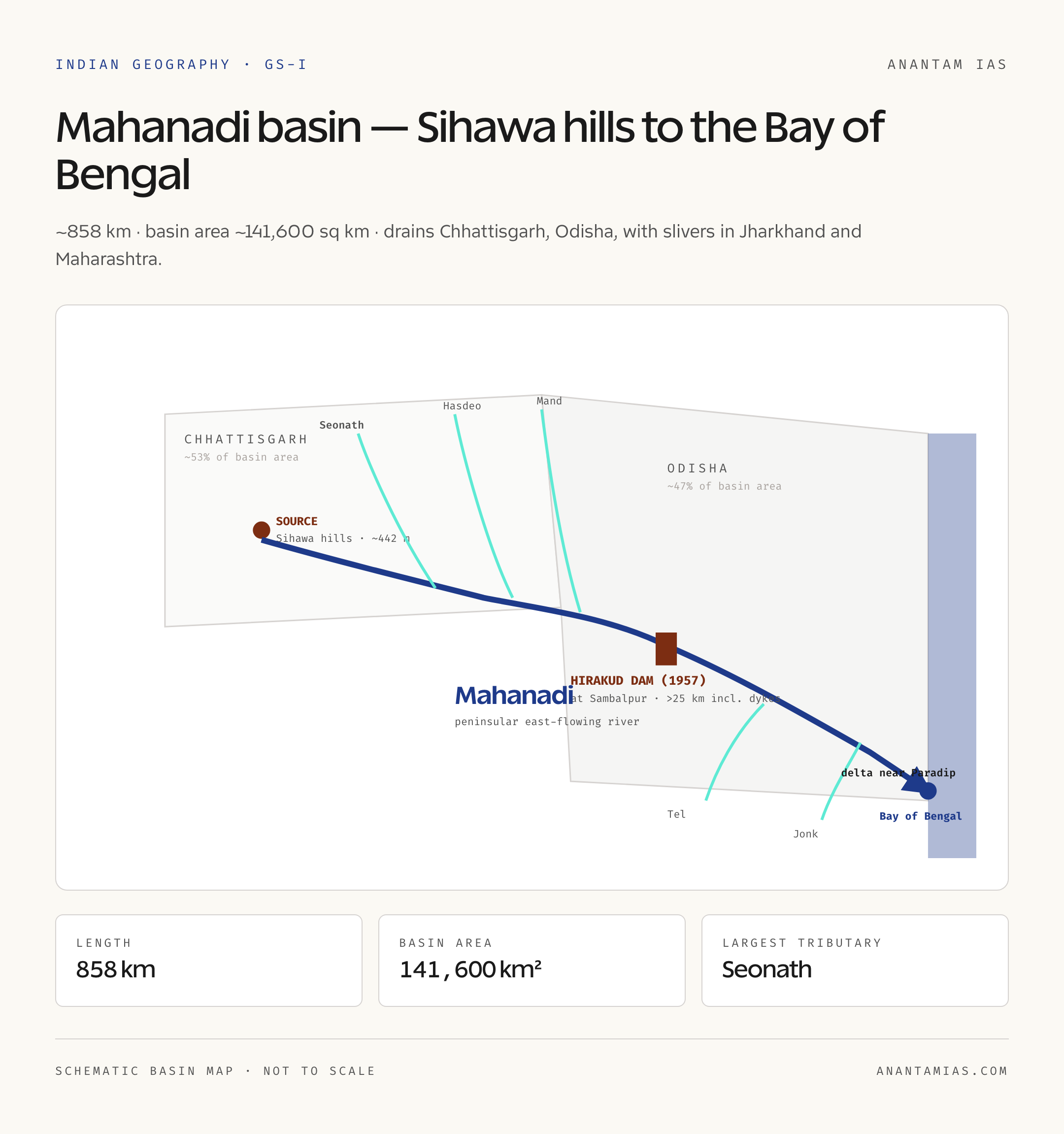
- River: Mahanadi (literally “great river” in Sanskrit)
- Length: Approximately 858 km
- Source: Sihawa hills, Dhamtari district, Chhattisgarh (around 442 m elevation)
- Mouth: Bay of Bengal, near Paradip in Odisha (forms a large delta)
- Basin area: Approximately 141,600 sq km
- Basin states: Chhattisgarh, Odisha, Jharkhand, Maharashtra (small portion)
- Major tributaries: Seonath, Hasdeo, Mand, Ib (left bank); Ong, Tel, Jonk (right bank)
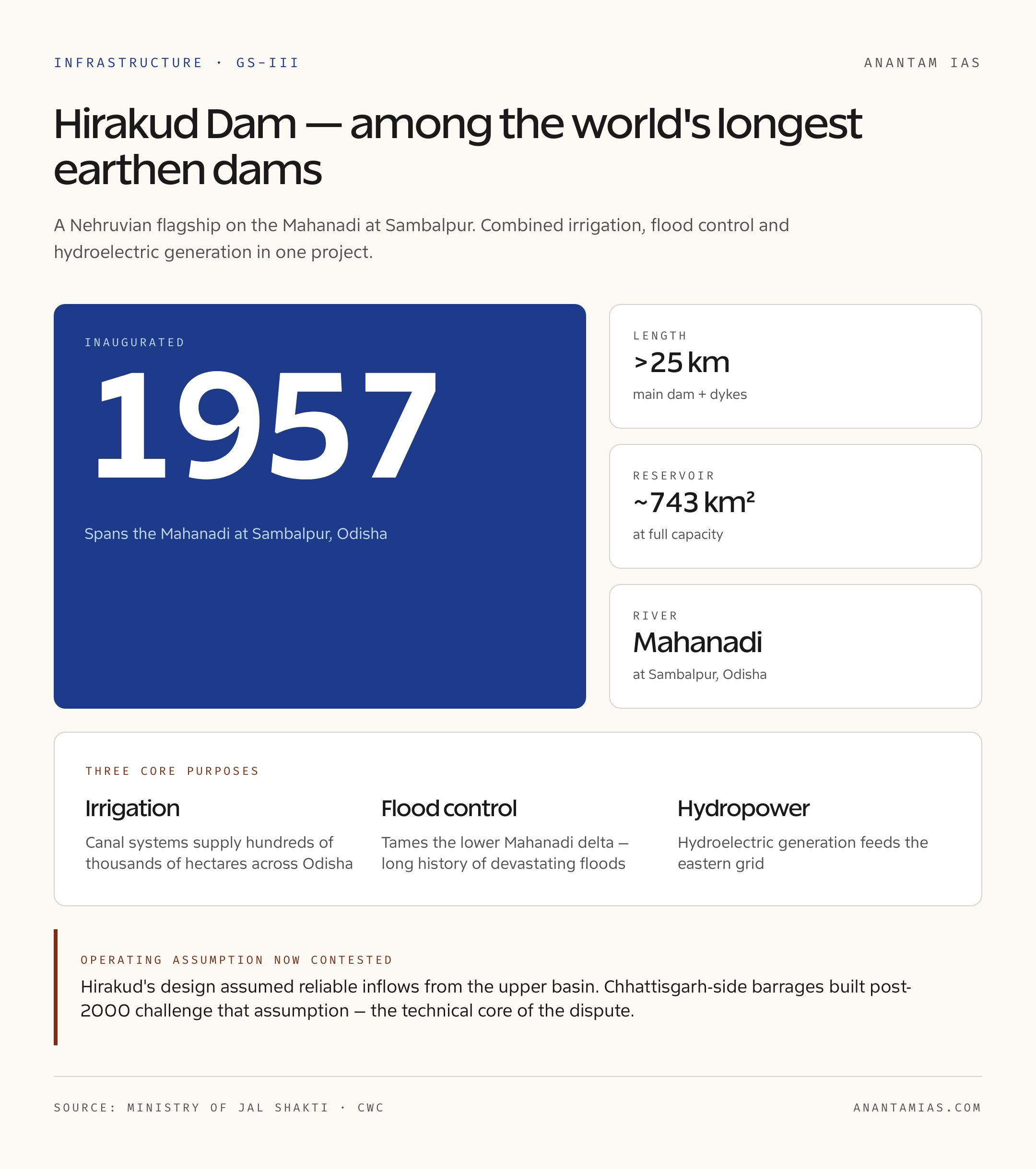
- Major dam: Hirakud Dam (commissioned 1957, world’s longest earthen dam at over 25 km including dykes)
- Direction of flow: Generally west to east (peninsular east-flowing river)
- Key dispute: Odisha vs Chhattisgarh over upstream barrages
- Tribunal: Mahanadi Water Disputes Tribunal, constituted March 2018
What Just Happened: Tribunal Hearings and Renewed Tensions
The Mahanadi River dispute returned to news in late April 2026 as the Mahanadi Water Disputes Tribunal continued substantive hearings. Odisha has consistently argued that Chhattisgarh’s upstream barrages and weirs (built largely after the state’s formation in 2000) have reduced flows to the Hirakud reservoir, especially during the non-monsoon months when storage is most critical. Chhattisgarh has argued that its upstream uses are within its share of the basin’s resources, and that Odisha overstates the impact of Chhattisgarh-side projects.
The tribunal was constituted in March 2018 under the Inter-State River Water Disputes Act, 1956, after Odisha approached the Supreme Court seeking a binding allocation. As per latest available data, the tribunal is in extended hearings, with deadlines repeatedly pushed forward, which is characteristic of how Indian water tribunals tend to function.
Background and Historical Context
How the Mahanadi Dispute Built Up
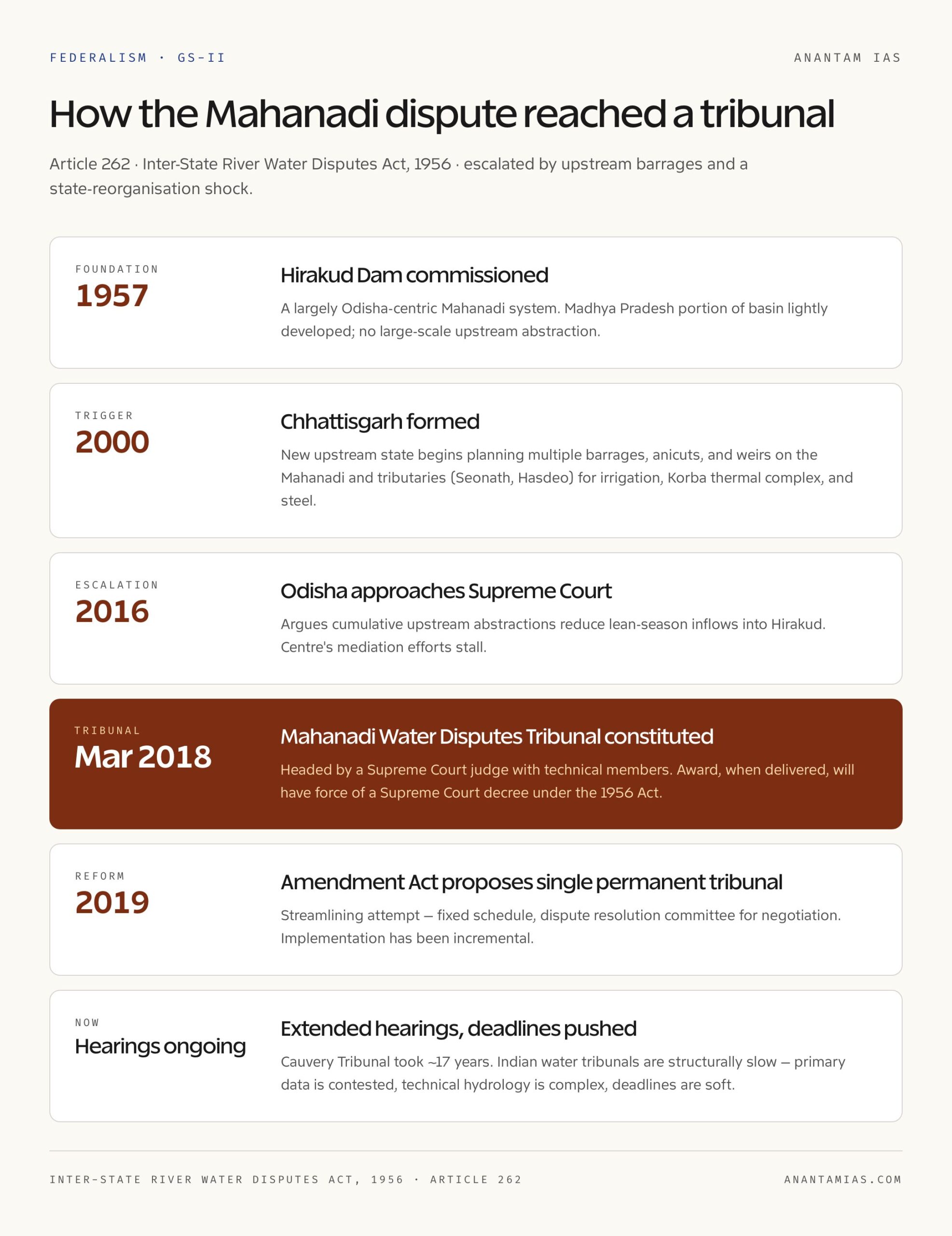
For most of independent India’s history, the Mahanadi River basin was managed as a largely Odisha-centric system. Odisha got the Hirakud Dam in 1957 — at the time the world’s longest earthen dam, a Nehruvian flagship that combined irrigation, flood control, and hydroelectric power. The basin’s headwaters in the Madhya Pradesh portion (which became Chhattisgarh in 2000) were lightly developed. The hydrological status quo worked because no large-scale upstream abstraction existed.
That changed after Chhattisgarh’s formation. The new state had legitimate development priorities: industrial growth in the central Chhattisgarh plains, expanded irrigation in the Mahanadi basin’s upper reaches, and water supply for the Korba thermal power complex and other industrial users. Multiple barrages, anicuts, and weirs were planned and constructed on the Mahanadi and its tributaries (the Seonath, Hasdeo, and others) over the 2000s and 2010s.
Odisha began protesting in the early 2010s, arguing that cumulative upstream abstractions were reducing inflows into the Hirakud reservoir during the lean (non-monsoon) season. The state took the matter to the Supreme Court in 2016, and after the Centre’s mediation efforts stalled, the Mahanadi Water Disputes Tribunal was constituted in March 2018.
Geographic Setting and Key Features
The Mahanadi River rises in the Sihawa hills of Dhamtari district in Chhattisgarh, at about 442 meters elevation. From there it flows generally north and then east through the Chhattisgarh plains, picking up its largest tributary, the Seonath, near Sheorinarayan. The combined flow continues into Odisha, where it enters the Hirakud reservoir at Sambalpur.
Below Hirakud, the Mahanadi flows through eastern Odisha, gathers more tributaries including the Tel and Jonk, and eventually splits into a complex deltaic network before emptying into the Bay of Bengal near Paradip. The delta is one of the most fertile rice-growing regions in eastern India.
Major tributaries (left bank): Seonath (the largest), Hasdeo, Mand, Ib. The Seonath itself drains a substantial chunk of central Chhattisgarh.
Major tributaries (right bank): Ong, Tel, Jonk.
Basin states: Chhattisgarh contains roughly 53 percent of the basin area, Odisha about 47 percent, with small slivers in Jharkhand and Maharashtra.
Climate and discharge: The Mahanadi basin receives most of its rainfall from the southwest monsoon between June and September. The river is highly seasonal, with peak flows during the monsoon and substantially lower flows during the dry months. This seasonality is central to the dispute, because upstream abstractions during the lean season have an outsized impact on downstream availability.
Why the Mahanadi River Matters
Three reasons. First, the Mahanadi River is the agricultural backbone of Odisha. Hirakud-fed canal systems irrigate hundreds of thousands of hectares, and any reduction in lean-season flow translates directly into reduced rabi crop output. Second, the basin is industrially important on both sides: thermal power, mining, and steel in Chhattisgarh, and similar uses plus port-related industry in Odisha. Third, the dispute is a stress test for India’s inter-state river dispute mechanism, which has struggled to deliver timely resolutions across the country.
Detailed Analysis
The Hirakud Dam
Hirakud is one of the iconic structures of post-independence India. Inaugurated in 1957, it spans the Mahanadi at Sambalpur with a main dam and a network of dykes that, taken together, exceed 25 kilometers in length, making it among the longest earthen dams in the world. The reservoir is about 743 square kilometers at full capacity. The project has three core purposes: irrigation, flood control for the lower Mahanadi delta (which had a long history of devastating floods), and hydroelectric generation.
Hirakud’s design assumed reliable inflows from the upper basin. That assumption is now contested by Chhattisgarh-side projects, which is the technical core of the dispute.
Chhattisgarh’s Upstream Projects
Chhattisgarh has built or planned multiple barrages and weirs on the main Mahanadi and on tributaries like the Seonath and Hasdeo. Some are for irrigation, some for industrial water supply (notably for thermal power plants in the Korba region and steel facilities in the Raipur-Bhilai belt). Odisha’s case is that the cumulative effect, especially during the non-monsoon months, has reduced inflows into Hirakud below the historical baseline.
Chhattisgarh’s case is that the 75 percent dependable yield available to upstream basin states under accepted hydrological norms is sufficient for its planned uses, and that monsoon-season flows (which dominate annual runoff) are not significantly affected.
The Tribunal Mechanism
The Inter-State River Water Disputes Act, 1956 is the constitutional vehicle for adjudicating these conflicts. Article 262 of the Constitution authorizes Parliament to legislate on inter-state river disputes and to bar Supreme Court jurisdiction in such matters. Under the Act, the central government constitutes a tribunal when negotiation fails. Past tribunals include the Krishna, Godavari, Cauvery, Ravi-Beas, and Vansadhara tribunals.
The Mahanadi Water Disputes Tribunal was constituted in March 2018, headed by a Supreme Court judge with technical members. The tribunal’s award, when finalized, will be binding and will have the force of a Supreme Court decree under the 1956 Act.
Why Tribunals Are Slow
Indian water tribunals have a poor reputation for timeliness. The Cauvery Tribunal took nearly 17 years to deliver its final award. The Ravi-Beas case has been open for decades. The reasons include the technical complexity of hydrology, the politicized nature of state submissions, the need for primary data collection in basins where shared monitoring is weak, and the structural design of the Act, which lacks strict deadlines.
The Inter-State River Water Disputes (Amendment) Act, 2019 attempted to streamline the process by proposing a single permanent tribunal with a fixed schedule, but implementation has been incremental.
For more on inter-state federalism issues, our piece on the 73rd Amendment covers a related dimension of how power is divided in India’s federal structure.
Comparative Perspective: India’s Major Inter-State Water Disputes
The Mahanadi River dispute fits a recognizable pattern.
Cauvery: Karnataka vs Tamil Nadu (with Kerala and Puducherry). Tribunal constituted 1990, final award 2007, Supreme Court modification 2018, Cauvery Water Management Authority operational. Our explainer on the Cauvery river goes into depth.
Krishna: Andhra Pradesh, Telangana, Karnataka, Maharashtra. KWDT-I (1969-1976), KWDT-II (2004 onwards), still active.
Godavari: Resolved relatively well by the Bachawat Tribunal (1969-1979).
Ravi-Beas: Punjab, Haryana, Rajasthan. Long-running, politically explosive (the Sutlej-Yamuna Link canal issue).
Vansadhara: Odisha vs Andhra Pradesh, tribunal 2010, award 2017.
The Mahanadi dispute is structurally most similar to Cauvery and Krishna in that an upstream-downstream dynamic combined with state reorganization (Chhattisgarh, like Telangana) created the conditions for conflict.
Challenges and Critiques
Three structural problems show up in the Mahanadi case. First, basin-wide planning is weak. There is no robust river basin organization with statutory authority over the Mahanadi as a whole. Second, primary data on actual abstractions, flows, and reservoir operations is contested. Both states present different numbers, which makes adjudication slow. Third, the time horizon is wrong. By the time tribunals deliver awards, the ground reality has often shifted because more projects have been built.
Critics also argue that the political incentive structure favors prolonging disputes. State governments find it politically convenient to fight rather than settle, and the tribunal mechanism gives them a face-saving forum to do so without conceding ground.
For broader context on Indian water governance, our Indian geography maps reference covers the country’s river basins and our piece on the Ken River discusses inter-basin transfer ambitions.
UPSC Prelims Pointers
- The Mahanadi River rises in the Sihawa hills of Dhamtari district, Chhattisgarh
- Total length approximately 858 km
- Basin states: Chhattisgarh, Odisha, Jharkhand, Maharashtra (small)
- Largest tributary: Seonath (left bank); other left-bank tributaries include Hasdeo, Mand, Ib
- Right-bank tributaries: Ong, Tel, Jonk
- Empties into the Bay of Bengal forming a delta near Paradip in Odisha
- Hirakud Dam (commissioned 1957) is among the longest earthen dams in the world
- Mahanadi Water Disputes Tribunal constituted in March 2018
- Tribunals operate under the Inter-State River Water Disputes Act, 1956 (Article 262)
- Inter-State River Water Disputes (Amendment) Act, 2019 proposed a single permanent tribunal
Mains Practice Questions
- GS Paper I: Discuss the geographical features of the Mahanadi basin and explain how the river’s seasonality and basin distribution have shaped the current Odisha-Chhattisgarh water dispute. (250 words)
- GS Paper II: “The Inter-State River Water Disputes Act, 1956 has structural shortcomings that the 2019 amendment only partially addresses.” Examine in light of the Mahanadi tribunal’s progress. (250 words)
- GS Paper III: Discuss the role of the Hirakud Dam in Odisha’s agriculture and flood management. How do upstream developments threaten its operational assumptions? (250 words)
- GS Paper II: Compare the Mahanadi dispute with the Cauvery and Krishna disputes. What common patterns emerge, and what reforms in inter-state water governance does the comparison suggest? (150 words)
Way Forward
The Mahanadi case calls for three reforms. First, a credible river basin organization with statutory powers over the Mahanadi basin as a whole, with both state governments and the Centre at the table. Second, transparent, jointly maintained hydrological data — real-time flow monitoring, standardized measurement protocols, and shared dashboards. Third, faster tribunal procedures with hard deadlines, which the 2019 amendment gestures at but has not fully delivered.
There’s also a broader case for shifting from rigid annual allocations to flexible, climate-aware sharing rules. The Mahanadi basin will face more variable monsoons in coming decades, and rules designed for 1957 hydrology won’t fit 2050 hydrology.
For UPSC aspirants, the Mahanadi River dispute is one of those topics where prelims facts (length, source, tributaries, tribunal year) and mains arguments (federalism, water governance, climate adaptation) sit comfortably together. Worth knowing both layers. You can pair this with our broader geography reference at Indian geography maps.
Frequently Asked Questions
What is the source of the Mahanadi River?
The Mahanadi River rises in the Sihawa hills of Dhamtari district in Chhattisgarh, at an elevation of about 442 meters.
Which states does the Mahanadi River basin cover?
The basin covers Chhattisgarh (about 53 percent), Odisha (about 47 percent), and small portions of Jharkhand and Maharashtra.
What is the Mahanadi Water Disputes Tribunal?
It is a tribunal constituted by the central government in March 2018 under the Inter-State River Water Disputes Act, 1956 to adjudicate the Odisha-Chhattisgarh dispute over Mahanadi waters.
Why is Hirakud Dam significant?
Hirakud Dam, commissioned in 1957, is among the world’s longest earthen dams (over 25 km including dykes) and serves irrigation, flood control, and hydroelectric purposes for Odisha.
What are the major tributaries of the Mahanadi?
The principal left-bank tributaries are the Seonath (the largest), Hasdeo, Mand, and Ib. Right-bank tributaries include the Ong, Tel, and Jonk.
Why did the Mahanadi dispute emerge after 2000?
Chhattisgarh’s formation in 2000 created a new upstream state that began building barrages and weirs for irrigation and industrial water supply, which Odisha argues has reduced lean-season flows into the Hirakud reservoir.
Under what constitutional provision are inter-state water disputes adjudicated?
Article 262 of the Constitution authorizes Parliament to legislate on inter-state river disputes. The Inter-State River Water Disputes Act, 1956 is the statutory framework.
What did the 2019 amendment to the Inter-State River Water Disputes Act propose?
The 2019 amendment proposed a single permanent tribunal with a dispute resolution committee for negotiation and stricter timelines, aimed at reducing the chronic delays seen in earlier tribunals.
Tell Google you want more of this.
Add Anantam IAS as a preferred sourceOne tap, and this site shows up more often in your own Top Stories, AI Overviews and AI Mode. Remove it any time.