Frontiers and boundaries are not two words for the same thing, and the distinction is the foundation of political geography. A frontier is a zone; a boundary is a line. One faces outward and invites settlement; the other faces inward and fixes jurisdiction. Every dispute over a border is, at bottom, an argument about which of the two a place is.
Frontier Against Boundary
| Frontier | Boundary | |
|---|---|---|
| Form | A zone, with width | A line, without width |
| Orientation | Faces outward, away from the settled core | Faces inward, enclosing the state |
| Function | A zone of transition, contact and settlement | A precise limit of sovereignty |
| Legal status | Rarely defined in law | Defined by treaty and marked on the ground |
| Historical moment | Characteristic of expanding or pre-modern states | Characteristic of the modern state system |
Frontiers preceded boundaries historically, and the shift from one to the other is the spatial expression of the modern state’s claim to exclusive authority within a fixed territory.
The Four Stages of Boundary Making
A boundary is made in a sequence, and the terms are frequently confused with one another.
- Definition: the treaty text describing where the line runs, in words.
- Delimitation: drawing that description onto a map.
- Demarcation: marking it physically on the ground with pillars, fences or posts.
- Administration: maintaining and managing it thereafter.
Most boundary disputes live in the gap between the first two stages and the third. A boundary can be defined and delimited and remain undemarcated for decades, and an undemarcated boundary is where incidents happen.
Hartshorne’s Genetic Classification
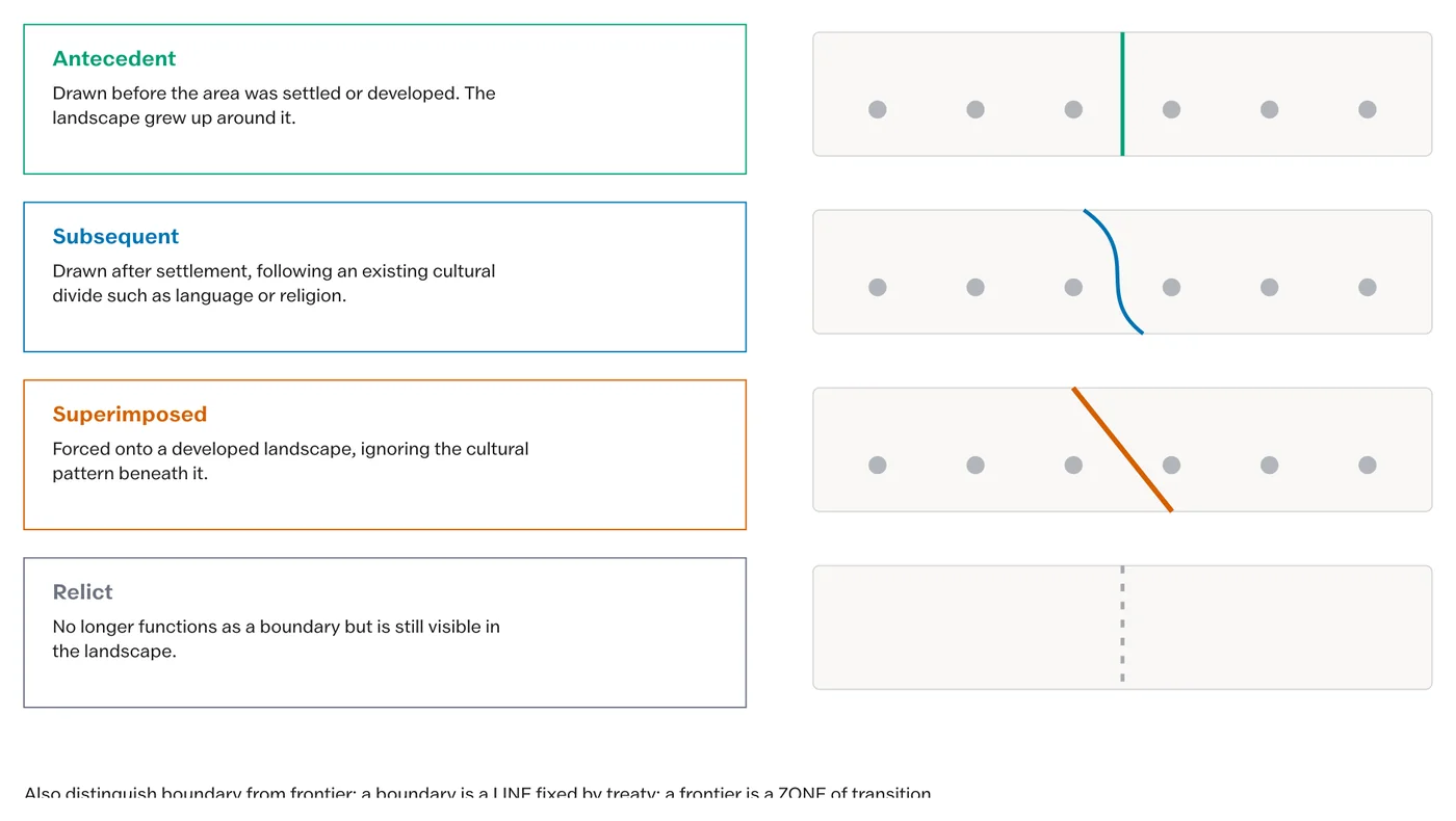
Richard Hartshorne classified boundaries by their relationship to the cultural landscape at the moment they were drawn. This is the classification most often asked for, and its value is that it predicts how much trouble a boundary will cause.
- Antecedent: drawn before the area was settled or its cultural landscape developed, so settlement grew up on either side of an existing line. The United States and Canada boundary along the 49th parallel is the standard case.
- Subsequent (also called consequent): drawn after the cultural landscape developed and conforming to a divide already present in it, such as a linguistic or religious one. Most European boundaries are of this kind.
- Superimposed: drawn after the landscape developed and against it, ignoring existing patterns. The colonial boundaries of Africa are the standard case, and the Durand Line is the South Asian one.
- Relict: no longer functioning as a boundary but still visible in the landscape through settlement, land use, road pattern and building style. The former inner German border is the classic example.
The predictive value is straightforward. Superimposed boundaries generate the most conflict, because they cut through communities that had no part in drawing them. Antecedent boundaries generate the least, because nobody was displaced by them.
Classification by Physical Feature
A second classification runs by what the boundary follows, and each type has a characteristic failure mode.
| Type | Follows | Characteristic problem |
|---|---|---|
| Geometric | A line of latitude or longitude, or a straight line | Ignores terrain and communities entirely |
| River | A watercourse | Rivers move; the channel shifts and the boundary becomes ambiguous |
| Watershed | A drainage divide | Divides are hard to locate precisely in broad or glaciated terrain |
| Mountain | A range crest | Crest, watershed and highest points need not coincide |
| Anthropogeographic | A linguistic, religious or ethnic divide | Such divides are gradients rather than lines |
The Thalweg Principle
Where a boundary follows a navigable river, international practice places it along the thalweg, the line of deepest water, rather than along a bank or the midpoint. The rule exists so that both states retain access to the navigable channel.
The complication is that a thalweg migrates. On a meandering river the deepest channel swings from bank to bank and shifts over time, and international law distinguishes accretion, gradual change which moves the boundary with the channel, from avulsion, an abrupt change of course which does not. That distinction is the substance of the Sir Creek dispute between India and Pakistan, where the two states disagree about whether the boundary follows the eastern bank or the mid-channel of a tidal creek in the Rann of Kachchh.
The Geopolitical Frameworks
Three schemes of global political space recur, and they are best held as a sequence of arguments about whether land power or sea power is decisive.
- Mackinder’s heartland. The interior of Eurasia, inaccessible to sea power and drained to landlocked or ice-bound seas, is the pivot of world politics. He named it the pivot area in 1904 and enlarged and renamed it the heartland in 1919, within the world island of Eurasia and Africa together.
- Spykman’s rimland. The decisive belt is not the interior but the coastal and peninsular fringe of Eurasia, running from Western Europe through West and South Asia to East Asia, because it holds the population, the industry and the ports and is accessible to both land and sea power. It is Mackinder’s inner crescent with the opposite conclusion drawn from it.
- Cohen’s geostrategic realms. The world divides into a maritime realm and a Eurasian continental realm, each containing geopolitical regions, with shatterbelts between them: regions internally fragmented and caught between competing external powers, so that the two conditions reinforce each other.
Mackinder said the interior decides. Spykman said the fringe decides. India lies in the fringe, which is why the argument is not academic here.
India’s Boundaries
India’s land boundaries illustrate almost every category above.
- The Durand Line with Afghanistan is superimposed, drawn in 1893 across Pashtun territory.
- The Radcliffe Line of 1947 is superimposed, drawn in weeks across settled agrarian districts.
- The McMahon Line follows a watershed principle and is disputed, in part because crest and watershed do not coincide.
- The Line of Control is a ceasefire line rather than an international boundary, which is a legally distinct category.
- Sir Creek is the thalweg dispute described above.
The geographical contribution to any of these is the part usually left out of the diplomatic account: the terrain, the corridor, the watershed and the river channel are what make a line easy or impossible to hold.
What is the difference between a frontier and a boundary?
A frontier is a zone with width, facing outward from the settled core, characterised by transition and settlement. A boundary is a line without width, facing inward, legally defined, whose function is to fix the limit of sovereignty exactly.
What are the four stages of boundary making?
Definition, meaning the treaty text describing the line in words; delimitation, drawing it on a map; demarcation, marking it physically on the ground; and administration, maintaining it thereafter. Most disputes arise where a boundary is delimited but never demarcated.
What is Hartshorne’s genetic classification of boundaries?
A classification by the boundary’s relation to the cultural landscape when drawn. Antecedent boundaries precede settlement; subsequent boundaries follow an existing cultural divide; superimposed boundaries are drawn against the existing pattern; relict boundaries no longer function but remain visible in the landscape.
What is the thalweg principle?
The rule that a boundary along a navigable river follows the line of deepest water rather than a bank or the midpoint, so that both states retain access to the channel. It is the substance of the Sir Creek dispute between India and Pakistan.
What is the difference between the heartland and the rimland?
Mackinder’s heartland is the interior of Eurasia, inaccessible to sea power, which he held to be the pivot of world politics. Spykman’s rimland is the coastal and peninsular fringe, which he held to be decisive because it holds the population, industry and ports and is accessible to both land and sea power.
What is a shatterbelt?
In Cohen’s scheme, a region that is internally fragmented along ethnic, religious or political lines and simultaneously caught between competing external great powers. Both conditions must hold together: a divided region with no external interest is simply divided.
Practice Questions
Prelims
1. A boundary drawn before an area was settled is termed
- (a) subsequent
- (b) antecedent
- (c) superimposed
- (d) relict
Answer: (b)
2. The colonial boundaries of Africa are the standard example of a
- (a) antecedent boundary
- (b) subsequent boundary
- (c) superimposed boundary
- (d) relict boundary
Answer: (c)
3. The thalweg is the
- (a) mid-point of a river
- (b) line of deepest water in a river
- (c) outer bank of a meander
- (d) watershed between two basins
Answer: (b)
4. The concept of the rimland was formulated by
- (a) Halford Mackinder
- (b) Nicholas Spykman
- (c) Saul Cohen
- (d) Richard Hartshorne
Answer: (b)
5. Demarcation of a boundary refers to
- (a) describing it in a treaty
- (b) drawing it on a map
- (c) marking it physically on the ground
- (d) maintaining it over time
Answer: (c)
Mains
- Distinguish between a frontier and a boundary. (10 marks)
- Explain Hartshorne’s genetic classification of boundaries with one example of each type. (15 marks)
- What is the thalweg principle, and how does it bear on the Sir Creek dispute? (10 marks)
- Compare Mackinder’s heartland thesis with Spykman’s rimland thesis and assess their relevance to India. (20 marks)
- “India’s boundaries illustrate every category of the genetic classification.” Discuss. (20 marks)
Tell Google you want more of this.
Add Anantam IAS as a preferred sourceOne tap, and this site shows up more often in your own Top Stories, AI Overviews and AI Mode. Remove it any time.