

Strait of Malacca and Important Straits for UPSC 2026
A strait is a narrow channel of water connecting two larger bodies of water. Straits have shaped history — whoever controls a strait, controls the movement of ships, goods, and military forces. They’re the chokepoints of the global economy.
For UPSC, straits appear in Prelims (map-based, factual), Mains GS Paper 1 (world geography), GS Paper 2 (international relations, maritime security), and GS Paper 3 (trade, economy).
What Makes a Strait Strategically Important?
A strait becomes geopolitically significant when:
- Trade volume passing through is high (oil, LNG, container cargo)
- No alternative route exists nearby
- Naval access is critical for regional or global powers
- Two significant water bodies are connected
These factors define a maritime chokepoint — a strait whose closure would significantly disrupt global trade or military movement.
Complete List of Major World Straits
| Strait | Connects | Between | Strategic Importance |
|---|---|---|---|
| Strait of Malacca | Andaman Sea / Indian Ocean → South China Sea / Pacific | Malaysia (Malay Peninsula) and Indonesia (Sumatra) | World’s busiest; ~80% of China’s oil imports |
| Strait of Hormuz | Persian Gulf → Gulf of Oman → Arabian Sea | Iran and Oman | ~20% of global oil trade; critical for Middle East exports |
| Strait of Gibraltar | Atlantic Ocean → Mediterranean Sea | Spain (Europe) and Morocco (Africa) | Gateway to Mediterranean; NATO strategic interest |
| Bosphorus (Istanbul Strait) | Black Sea → Sea of Marmara → Aegean Sea | European Turkey and Asian Turkey | Russia’s only warm-water naval exit to Mediterranean |
| Strait of Dover | English Channel → North Sea | England (UK) and France | Busiest shipping lane in the world |
| Palk Strait | Bay of Bengal → Palk Bay | India (Tamil Nadu) and Sri Lanka | India-Sri Lanka connection; Adam’s Bridge/Ram Setu |
| Ten Degree Channel | Andaman Sea → Indian Ocean | Andaman Islands and Nicobar Islands (India) | Separates Andaman and Nicobar groups |
| Eight Degree Channel | Arabian Sea | Minicoy Island and Maldives | India’s southern maritime limit |
| Nine Degree Channel | Arabian Sea | Lakshadweep Islands | Separates Lakshadweep groups |
| Strait of Magellan | Atlantic Ocean → Pacific Ocean | Chile mainland and Tierra del Fuego | Southern South America; alternative to Drake Passage |
| Drake Passage | Atlantic Ocean → Pacific Ocean | South America (Cape Horn) and Antarctica | Stormiest sea passage; southernmost |
| Mozambique Channel | Indian Ocean (Madagascar Strait) | Mozambique (Africa) and Madagascar | Important for shipping around Africa |
| Bass Strait | Tasman Sea → Southern Ocean | Australia (Victoria/NSW) and Tasmania | Australia |
| Torres Strait | Coral Sea → Arafura Sea | Australia (Queensland) and Papua New Guinea | Pacific-Indian Ocean route |
| Luzon Strait | South China Sea → Pacific | Philippines (Luzon) and Taiwan | China’s naval access to Pacific |
| Sunda Strait | Indian Ocean → Java Sea | Indonesia (Sumatra) and Java | Alternative to Malacca for ships |
| Lombok Strait | Indian Ocean → Bali Sea | Indonesia (Bali) and Lombok | Deep-water alternative to Malacca |
| Makassar Strait | Sulawesi Sea → Java Sea | Borneo and Sulawesi (Indonesia) | Part of Indonesian Throughflow |
| Korea Strait | Sea of Japan → East China Sea | South Korea and Japan | Japan-Korea maritime boundary |
| Taiwan Strait | South China Sea → East China Sea | China (Fujian) and Taiwan | Major flashpoint; contested by China |
| Strait of Florida | Gulf of Mexico → Atlantic Ocean | Florida (USA) and Cuba | US maritime |
| Yucatan Channel | Caribbean Sea → Gulf of Mexico | Mexico (Yucatan) and Cuba | Gulf of Mexico gateway |
| Bab-el-Mandeb | Red Sea → Gulf of Aden | Yemen (Arabia) and Djibouti/Eritrea (Africa) | Red Sea chokepoint; Suez Canal access route |
The Strait of Malacca: India’s Key Concern
The Strait of Malacca is the world’s most important strait for India and for global trade.
Geography
- Length: ~800 km
- Narrowest point: ~2.7 km wide (near Tanjung Piai, Malaysia — the southernmost tip of mainland Asia)
- Depth: Shallow in parts (~25 m minimum at narrowest), limiting vessel draught
- Borders: Malaysia and Singapore on the north; Indonesia (Sumatra) on the south
Trade Significance
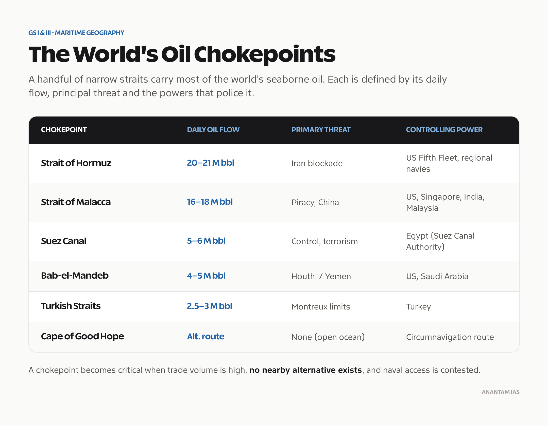
- Over 100,000 vessels pass through annually (~270 per day)
- Carries approximately one-third of global trade by value
- 80% of China’s oil imports pass through Malacca from the Middle East and Africa
- 50% of Japan and South Korea’s oil transits here
- 40% of global seaborne trade
- Connects the Indian Ocean to the South China Sea and the Pacific
For India, nearly all trade with Southeast Asia, East Asia (China, Japan, South Korea), and the Pacific passes through or near this strait.
The “Malacca Dilemma”
Chinese strategists coined this term: China’s over-dependence on the Malacca Strait for energy imports is a strategic vulnerability. The US Navy or India could potentially disrupt these supply lines in a conflict. This has driven China to:
- Build oil pipelines bypassing Malacca (Myanmar-Yunnan pipeline)
- Develop alternative ports (CPEC, Gwadar, Colombo, Hambantota)
- Expand the PLAN (People’s Liberation Army Navy) in the Indian Ocean
India’s response: The Andaman and Nicobar Command (India’s only tri-services command) is positioned right at the northern entrance to the Malacca Strait. India has developed INS Kohassa and other facilities in the Andamans to monitor and project power near Malacca.
Why India Cares About Malacca
- India’s trade with Southeast and East Asia depends on free navigation through Malacca
- Energy imports from the Gulf pass through the Indian Ocean, and return cargoes go toward East Asia
- Any Chinese control or harassment around Malacca would threaten India’s economic interests
- India’s “Act East Policy” and QUAD (India, US, Japan, Australia) are partly aimed at keeping Indo-Pacific sea lanes open
Strait of Hormuz: The Oil Chokepoint
- Location: Between Iran (north) and Oman/UAE (south)
- Width: ~55 km, but the shipping lane is only ~3 km wide in each direction
- Significance: About 20% of global oil trade — roughly 17–20 million barrels per day
- All oil exports from Saudi Arabia, UAE, Kuwait, Iraq, Qatar, and Iran pass through here
- About 80% of India’s oil imports from the Gulf region pass through Hormuz
- Iran has repeatedly threatened to close Hormuz during US sanctions standoffs
- India’s concern: Any closure would immediately spike oil prices and severely affect India’s import bill
The Strait of Hormuz is perhaps the world’s most tension-laden waterway. US Navy’s Fifth Fleet is headquartered in Bahrain specifically to protect it.
Bab-el-Mandeb: The Red Sea Gateway
- Location: Between Yemen (Arabian Peninsula) and Djibouti/Eritrea (Africa)
- Width: ~29 km
- Significance: All ships using the Suez Canal must pass through Bab-el-Mandeb
- Houthi attacks (2023-2024): Yemen’s Houthi rebels began attacking commercial ships in the Red Sea in late 2023 in response to the Israel-Gaza war, forcing most global shipping to reroute around the Cape of Good Hope — adding ~10 days and significant cost
- India’s concern: India is a major user of the Suez Canal for trade with Europe and the Mediterranean. The Houthi attacks severely disrupted India’s trade with the West.
Palk Strait: India’s Local Strait
- Location: Between India (Tamil Nadu coast) and Sri Lanka (Northern Province)
- Width: 53–80 km
- Connected waters: Bay of Bengal (north) to Palk Bay (south), which connects to Gulf of Mannar
- Adam’s Bridge/Ram Setu: A chain of limestone shoals connecting Pamban Island (Rameswaram, India) to Mannar Island (Sri Lanka). Under 1 m deep in places. The proposed Sethusamudram Shipping Canal Project aims to dredge a channel through it, which remains highly controversial.
- Significance for India: Fishing disputes between Indian and Sri Lankan fishermen are a constant diplomatic issue. Tamil Nadu fishermen regularly venture into Sri Lankan territorial waters.
Bosphorus: Russia’s Strategic Bottleneck
- Location: Divides Istanbul between European and Asian Turkey
- Length: ~31 km, width: 700 m to 3 km
- Significance: Russia’s Black Sea Fleet (based in Sevastopol, Crimea) can only access the Mediterranean through the Bosphorus and Dardanelles straits
- Montreux Convention (1936): Governs navigation through the Bosphorus. In peacetime, commercial ships have free passage; warships of non-Black Sea states are restricted. Turkey can close the strait to warships during conflict.
- Ukraine War (2022): Turkey invoked the Montreux Convention to block Russian warships from passing through (except those returning to home ports) after Russia’s invasion of Ukraine
- India’s interest: India has abstained on several UN votes on Ukraine; Turkey-Russia-NATO dynamics around Bosphorus affect India’s strategic calculus
India’s Straits: The Channel System
India has its own system of channels (functionally equivalent to straits) in the Andaman and Lakshadweep archipelagos:
| Channel | Location | Connects |
|---|---|---|
| Ten Degree Channel | Between Andaman and Nicobar Islands | Bay of Bengal and Andaman Sea |
| Eight Degree Channel | Between Minicoy and Maldives | Arabian Sea (north and south of Lakshadweep) |
| Nine Degree Channel | Within Lakshadweep | Separates northern and southern Lakshadweep groups |
| Duncan Passage | Between South Andaman and Little Andaman | Andaman Sea |
| Coco Channel | Between Andaman Islands and Myanmar’s Coco Islands | Andaman Sea (India-Myanmar maritime) |
The Eight Degree Channel marks the approximate southern boundary of India’s Exclusive Economic Zone (EEZ) in the Arabian Sea.
Maritime Chokepoints: Strategic Summary
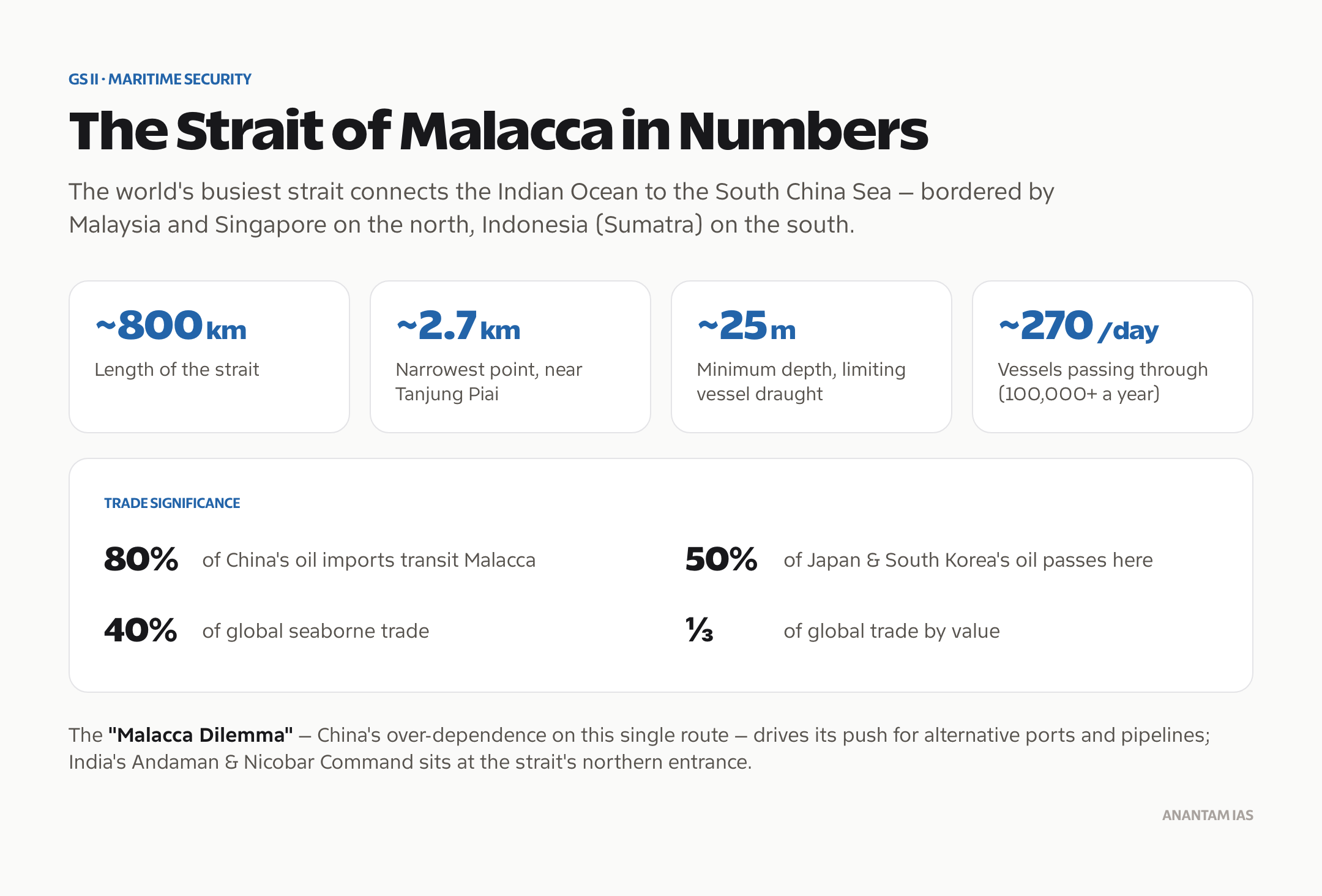
| Chokepoint | Daily Oil Flow | Primary Threat | Controlling Power |
|---|---|---|---|
| Strait of Hormuz | 20–21 million bbl | Iran blockade | US Fifth Fleet, regional navies |
| Strait of Malacca | 16–18 million bbl | Piracy, China | US, Singapore, India, Malaysia |
| Bab-el-Mandeb | 4–5 million bbl | Houthi/Yemen | US, Saudi Arabia |
| Suez Canal | 5–6 million bbl | Egypt control, terrorism | Egypt (Suez Canal Authority) |
| Turkish Straits | 2.5–3 million bbl | Turkey (Montreux) | Turkey |
| Cape of Good Hope | Alternative route | None (open ocean) | Circumnavigation route |
Freedom of Navigation
Freedom of Navigation (FON) is a principle of international maritime law (UNCLOS — United Nations Convention on the Law of the Sea, 1982) that guarantees ships of all nations the right to pass through international straits.
Key points:
- UNCLOS Article 38: Guarantees “transit passage” through international straits
- Transit passage cannot be suspended, unlike innocent passage in territorial waters
- China’s excessive maritime claims in the South China Sea (including over straits like Luzon) are challenged under UNCLOS
- Freedom of Navigation Operations (FONOPS) — US Navy regularly conducts these in the South China Sea and near the Strait of Taiwan to challenge China’s claims
- India supports UNCLOS and FON but has not conducted FONOPS itself
Atmosphere: Layers and Composition
Frequently Asked Questions
Q1. Which is the most important strait in the world for trade?
The Strait of Malacca is generally considered the most important strait in the world for international trade. About 100,000 vessels pass through annually, carrying approximately one-third of global trade by value. It’s critical for China’s oil imports from the Middle East, Japan and South Korea’s energy supplies, and trade between the Indian Ocean and Pacific regions.
Q2. Why is the Strait of Hormuz strategically important for India?
About 60–65% of India’s crude oil imports come from the Persian Gulf region — Saudi Arabia, Iraq, UAE, Kuwait — and all of it passes through the Strait of Hormuz. Any closure or disruption of Hormuz would immediately impact India’s oil supply and spike global oil prices. Iran’s threats to close the strait during sanctions periods are closely monitored by India.
Q3. What is the Malacca Dilemma?
The u0022Malacca Dilemmau0022 is a strategic concept coined by Chinese analysts acknowledging that China’s over-dependence on the Strait of Malacca for energy imports is a strategic vulnerability. In a conflict, a hostile power (the US, India, or both) could potentially disrupt these supply lines. China has tried to address this by building land-based pipelines (Myanmar-Yunnan), investing in alternative ports (Gwadar, Hambantota), and expanding its navy in the Indian Ocean. India’s Andaman & Nicobar Command is positioned directly at the entrance to the Malacca Strait.
Q4. What is the Montreux Convention?
The Montreux Convention (1936) is an international agreement that gives Turkey control over the Bosphorus and Dardanelles straits. Under it, commercial ships have free passage in peacetime. Warships of non-Black Sea nations face restrictions (tonnage limits, advance notice). During wartime, Turkey can close the straits to all warships. Turkey invoked this in 2022 during the Russia-Ukraine war to prevent additional warships from entering the Black Sea, significantly limiting Russia’s ability to reinforce its Black Sea Fleet.
Q5. What is the Ten Degree Channel and why is it important for India?
The Ten Degree Channel is a passage in the Indian Ocean that separates the Andaman Islands from the Nicobar Islands. It lies approximately at 10°N latitude (hence the name). It connects the Bay of Bengal to the Andaman Sea. It’s strategically important because it’s one of the natural gateways to the northern Malacca Strait, and India’s Andaman & Nicobar Command monitors this passage. The channel is about 150 km wide and is used by ships transiting between the Indian Ocean and the Pacific.
Tell Google you want more of this.
Add Anantam IAS as a preferred sourceOne tap, and this site shows up more often in your own Top Stories, AI Overviews and AI Mode. Remove it any time.






