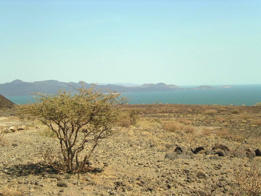
Lake Turkana — popularly called the Jade Sea for the striking blue-green colour it takes on under the desert sun — is the world’s largest permanent desert lake and the largest alkaline lake on the planet. It stretches roughly 290 km north-to-south through the arid Turkana basin of northern Kenya, with its northernmost tip crossing into southwestern Ethiopia. Lake Turkana is the fourth-largest of Africa’s Great Rift Valley lakes by area (around 6,400 sq km) and the third-largest by volume. It is also one of the most saline of the rift lakes — about 2.5 grams of salt per litre — yet supports a remarkable fish fauna, hippopotamus, the world’s largest population of Nile crocodiles, and around 350 bird species. The Lake Turkana National Parks have been a UNESCO World Heritage Site since 1997 (revised inscription) under both natural criteria and as a “cradle of humankind” given the hominin fossils found on its eastern shore at Koobi Fora.
The challenge facing Lake Turkana today is largely upstream. About 90 per cent of the lake’s inflow comes from the Omo River, which rises in the Ethiopian highlands. Ethiopia’s series of mega-dams on the Omo — Gibe I, II, III and the under-construction Gibe IV — combined with the vast Kuraz sugar plantations in the lower Omo, threaten to reduce inflow and accelerate lake-level decline. UNESCO placed Lake Turkana on the List of World Heritage in Danger in 2018 because of these upstream pressures.
Geographic Setting
Lake Turkana sits in the eastern arm of the East African Rift System in the northern Kenyan county of Turkana. The lake occupies a long, narrow rift basin between the Loriu Plateau in the west, the Suguta valley to the south, and a steep volcanic escarpment to the east. Three volcanic islands — South, Central and North — rise from the lake bed; each forms part of the Lake Turkana National Parks.
Dimensions
- Length: about 290 km
- Maximum width: 32 km
- Average depth: 30 m; maximum depth: 109 m
- Surface area: 6,400 sq km (variable)
- Catchment area: about 130,000 sq km
- Elevation: 360 m above sea level
The Omo River
The Omo River, rising in the Ethiopian Highlands south of Addis Ababa, is the dominant inflow — contributing about 90 per cent of the lake’s freshwater supply. The Turkwel and Kerio rivers, fed by the Cherangani Hills of Kenya, contribute the remaining 10 per cent but are themselves now dammed (Turkwel Gorge Dam). The lake has no outflow — it is endorheic — so all water lost is by evaporation, which exceeds 2,300 mm per year.
Geology and the East African Rift
Lake Turkana lies on the floor of the East African Rift, a still-active continental rift where the Somali tectonic plate is splitting away from the Nubian (African) plate at roughly 6-7 mm per year. The rift will eventually grow into an ocean if rifting continues over millions of years.
Volcanism
The basin floor is studded with active and dormant volcanoes — Central Island erupted as recently as the 19th century, and South Island has fumaroles. The shoreline is fringed with ancient lava flows and obsidian outcrops once quarried by prehistoric communities.
Comparison with Other Rift Valley Lakes
| Lake | Area (sq km) | Type | Country |
|---|---|---|---|
| Victoria | 68,800 | Shallow plateau | Uganda, Tanzania, Kenya |
| Tanganyika | 32,900 | Deep rift (1,470 m) | Tanzania, DRC, Burundi, Zambia |
| Malawi (Nyasa) | 29,500 | Deep rift (706 m) | Malawi, Mozambique, Tanzania |
| Turkana | 6,400 | Shallow desert rift | Kenya, Ethiopia |
| Albert | 5,300 | Western rift | Uganda, DRC |
| Kivu | 2,700 | Volcanic (CO2 saturated) | Rwanda, DRC |
| Edward | 2,300 | Western rift | Uganda, DRC |
| Naivasha | 139 | Freshwater closed | Kenya |
| Bogoria | 34 | Hot springs, saline | Kenya |
Lake Turkana is the largest of the rift’s truly desert lakes. Lake Eyasi (Tanzania) and Lake Natron are smaller, harsher salt lakes nearby. For contrast with the world’s most saline water body, see the Dead Sea; the same East African Rift system also hosts the continent’s highest peak, Mount Kilimanjaro.
Climate
The Turkana basin has a hot, arid climate. Mean annual temperature exceeds 30 C, rainfall averages just 200-250 mm and is highly erratic, and evaporation is around 2,300-2,500 mm per year. Strong easterly trade winds funnelled by the rift produce frequent dust storms and standing waves on the lake.
Why the Lake Is Jade
The distinctive jade-green hue comes from suspended blue-green algae (cyanobacteria), mainly Microcystis and Anabaena, that bloom in the warm, alkaline surface waters. The colour intensifies near volcanic islands where mineral nutrients enrich the upper layer.
Fauna of Lake Turkana
Fish
Despite the salinity, Lake Turkana supports about 60 fish species, mostly cichlids and tigerfish. Endemic species include Lates longispinis. Fishing is the principal occupation of lakeside communities.
Crocodiles
Lake Turkana holds the world’s largest concentration of Nile crocodiles (Crocodylus niloticus) — estimates range from 12,000 to 14,000 adults. They breed on the sandy beaches of Central Island, where the volcanic warmth incubates their eggs.
Hippos
Hippopotamus pods inhabit the southern and middle reaches of the lake, though numbers have fallen due to fishing competition and drought.
Birds
Over 350 bird species use Lake Turkana, including very large numbers of migratory shorebirds, lesser flamingos, white-faced whistling ducks, African skimmers, ospreys and herons. The lake is on the Asian-East African flyway, the same migration corridor used by some birds that winter in India.
Koobi Fora — The Cradle of Humankind
The eastern shore of Lake Turkana, at the Koobi Fora research base, has yielded some of the most important hominin fossils on Earth, including:
- Homo habilis — about 2.3 million years old
- Homo erectus / Homo ergaster — including KNM-ER 3733 and the Nariokotome Boy (H. erectus), a remarkably complete teenager dated to 1.6 million years ago
- Paranthropus boisei — KNM-ER 406 cranium
- Stone tools of the Oldowan and Acheulean industries
The hominin fossil sites helped Lake Turkana win its UNESCO inscription. The Turkana Basin Institute, led for decades by Richard and Meave Leakey, continues palaeo-anthropological excavations.
The Lake Turkana National Parks
Three national parks make up the UNESCO inscription:
- Sibiloi National Park on the eastern shore — Koobi Fora fossil beds and a stronghold of zebras, Grevy’s zebras, lions and oryx
- Central Island National Park — three crater lakes and the world’s biggest crocodile breeding site
- South Island National Park — flamingo populations and a cone of dormant volcanism
Indigenous Communities
About 10 distinct ethnic groups depend on Lake Turkana, including the Turkana, Dasanech, Gabbra, El Molo (one of Africa’s smallest tribes), Rendille and Samburu. Most are pastoralists, but the El Molo and parts of the Turkana have fishing economies. Severe drought cycles have pushed pastoralists into greater dependence on the lake’s fish.
Gibe III and the Threat from the Omo
Ethiopia’s Gibe III Dam (1,870 MW), completed in 2016, was the third in a planned cascade on the Omo River. Combined with the under-construction Gibe IV (Koysha Dam, 2,160 MW) and the diversion of Omo water for the 175,000-hectare Kuraz sugar plantations, the upstream regime is profoundly altered.
Documented Impacts
- Lake level has fallen by approximately 1.5 metres since 2015
- Lake salinity rising — fish stocks already declining
- Floodplain agriculture along the Omo deprived of natural flood pulse
- Inter-ethnic conflict in the lower Omo over shrinking grazing and fishing resources
UNESCO World Heritage in Danger
In June 2018 UNESCO added Lake Turkana to the List of World Heritage in Danger, citing the upstream dam impacts. The status remains in 2025, and Kenya has formally protested through diplomatic channels.
Climate Change Compounds the Threat
The Turkana basin is warming faster than the global average — about 1.8 C of warming since 1960 — and rainfall has become more erratic, with prolonged droughts (2017, 2019-23) followed by heavier short rains. The combination of upstream water diversion and climate stress is the most serious threat to Lake Turkana.
Lake Turkana and India — Indian Ocean Connections
Lake Turkana sits within the broader Indian Ocean climate system. Rainfall over the Ethiopian and Kenyan highlands is influenced by the Indian Ocean Dipole — positive IOD events bring heavier short rains, negative IOD years drought. Indian scientific cooperation with Kenya covers fisheries, oceanography (via Centre for Marine Living Resources and Ecology, Kochi) and meteorology.
Strategic and Cultural Significance
The lake corridor sits across one of Africa’s most important strategic axes — Kenya, Ethiopia, South Sudan and Somalia all share security interests around the Turkana-Omo borderlands. The proposed Lamu Port-South Sudan-Ethiopia Transport (LAPSSET) Corridor is designed to skirt Lake Turkana’s east shore. Cultural festivals like the Lake Turkana Festival celebrate the rich diversity of pastoralist communities.
Frequently Asked Questions
Where is Lake Turkana?
Lake Turkana lies in northern Kenya, with its northernmost tip crossing into southwestern Ethiopia. It sits in the eastern arm of the East African Rift Valley.
Why is Lake Turkana called the Jade Sea?
Because of its striking blue-green colour caused by blue-green algae (cyanobacteria) blooming in the warm, alkaline water. The colour deepens around the volcanic islands.
Is Lake Turkana the largest desert lake in the world?
Yes. Lake Turkana is the world’s largest permanent desert lake and the largest alkaline lake on the planet, with a surface area of about 6,400 sq km.
What is the main inflow into Lake Turkana?
The Omo River from the Ethiopian Highlands contributes about 90 per cent of the lake’s freshwater. The Turkwel and Kerio rivers from Kenya provide the remaining 10 per cent.
Why is Lake Turkana a UNESCO World Heritage Site?
For its outstanding natural value (volcanic islands, crocodile and bird populations, rift geology) and for the Koobi Fora hominin fossil sites that document key stages of human evolution. It was inscribed in 1997.
Why did UNESCO list Lake Turkana as World Heritage in Danger?
Because of upstream dam and irrigation impacts — particularly Ethiopia’s Gibe III dam and the Kuraz sugar plantations — that have reduced the Omo River’s flow and lowered lake levels and biodiversity since 2015.
What hominin fossils have been found at Lake Turkana?
Fossils of Homo habilis, Homo erectus/ergaster (including the Nariokotome Boy), and Paranthropus boisei — collectively documenting a long arc of human evolution between roughly 2.3 and 1.5 million years ago.
Is Lake Turkana freshwater or saline?
Lake Turkana is brackish — about 2.5 grams of salt per litre, much less than the ocean but enough to be classified as alkaline saline. The lake is endorheic with no outflow, so salt accumulates over time.
Tell Google you want more of this.
Add Anantam IAS as a preferred sourceOne tap, and this site shows up more often in your own Top Stories, AI Overviews and AI Mode. Remove it any time.