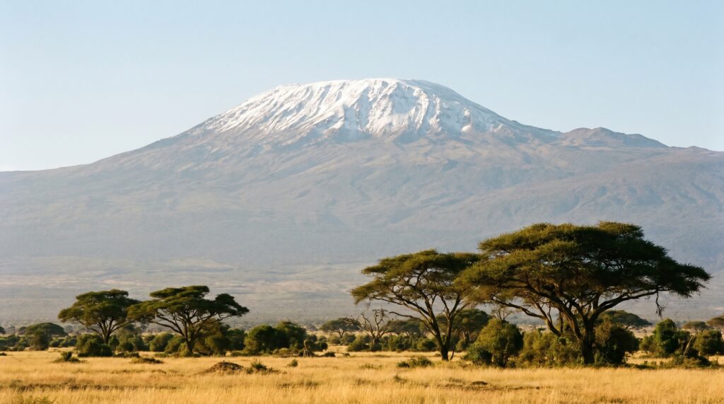
Ask which is the highest mountain in Africa and most people will guess right, Kilimanjaro. Ask the follow-up, what kind of mountain it is, and the confident answers fall apart. It is not part of a long range like the Himalaya, it was not pushed up by two plates colliding, and it is not extinct. Mount Kilimanjaro is a dormant volcano standing almost completely alone on a flat East African plain, rising to about 5,895 metres in northeastern Tanzania. That “standing alone” part is not a throwaway detail. It is the single fact that makes Kilimanjaro different from almost every other famous peak on Earth.
Here is what trips people up. Kilimanjaro is often called the roof of Africa, and it is, but the more precise claim is that it is the world’s tallest free-standing mountain, meaning it is not a summit within a range but a single massive cone bursting straight out of the surrounding plateau. It also carries three separate volcanic cones, a stack of climate zones you would normally have to travel from the equator to the poles to see, and a shrinking ice cap that has become one of the most photographed symbols of climate change. Get those layers straight and Kilimanjaro stops being a trivia answer and becomes a compact geography lesson.
What Mount Kilimanjaro actually is, and why “free-standing” matters
Mount Kilimanjaro is a dormant stratovolcano in northeastern Tanzania, close to the border with Kenya, and its highest point, Uhuru Peak, reaches about 5,895 metres above sea level. That makes it the highest mountain in Africa and one of the Seven Summits, the highest peaks on each of the seven continents.
The word doing the heavy lifting is free-standing. Most great mountains are part of a range: Everest sits inside the Himalaya, Mont Blanc inside the Alps. Kilimanjaro is different. It is a single volcanic mass rising abruptly from a plain that sits at roughly 900 metres, so the mountain climbs almost 4,900 metres from its own base to its summit, which is why it counts as the tallest free-standing mountain in the world. Translate that into something you can picture: you are standing on flat savanna with elephants and acacia trees, and a snow-capped cone taller than any building rises straight out of the ground in front of you, with no foothills leading up to it.
A stratovolcano, sometimes called a composite volcano, is the classic cone-shaped mountain built from alternating layers of hardened lava and ash, the same family as Japan’s Fuji. Kilimanjaro’s volcanism is tied to the East African Rift, the great crack where the African continent is slowly pulling apart, which is where the molten rock came from. If you have studied volcanoes and their types, Kilimanjaro is your textbook stratovolcano, and the East African Rift Valley is the reason it is there at all.
| Attribute | Detail |
|---|---|
| Height | About 5,895 m (Uhuru Peak) |
| Rank | Highest mountain in Africa; tallest free-standing mountain on Earth |
| Country | Tanzania (near the Kenya border) |
| Type | Dormant stratovolcano (composite volcano) |
| Volcanic cones | Kibo (highest, dormant), Mawenzi, Shira |
| Origin | Volcanism linked to the East African Rift |
| Protected area | Kilimanjaro National Park |
| UNESCO listing | World Heritage Site, 1987 |
| Meaning of Uhuru | “Freedom” in Swahili |
| Part of | The Seven Summits |
The three cones: Kibo, Mawenzi, and Shira
Kilimanjaro is not one volcano but three, built by three separate volcanic centres that grew together into a single mountain. From highest to lowest they are Kibo, Mawenzi, and Shira, and telling them apart is the cleanest way to show you actually understand the mountain rather than just its height.
Kibo is the youngest and highest of the three, and it is the one that carries Uhuru Peak and the summit ice cap. Kibo is dormant, not extinct, and that distinction matters: dormant means it is not erupting now but could again, and Kibo still has fumaroles, vents releasing volcanic gas, near its crater. Its last major eruption was hundreds of thousands of years ago, but the mountain is not geologically dead.
Mawenzi, at about 5,149 metres, is the second-highest cone, a jagged, heavily eroded pinnacle that looks nothing like Kibo’s smooth dome, because it is older and long extinct. Shira, the oldest at about 3,962 metres, is the most worn down of all: it collapsed and eroded into a broad plateau rather than a distinct peak. So the three cones are really three chapters of the mountain’s life, oldest and most eroded (Shira), older and extinct (Mawenzi), youngest and still dormant (Kibo). Hold them in that order and you have the mountain’s biography in three words.
Five worlds on one slope: the ecological zones
The most striking thing about climbing Kilimanjaro is that in a few days you pass through five distinct ecological zones, the rough equivalent of walking from the equator to the Arctic. This altitudinal zonation happens because temperature drops steadily with height, so each band of the slope has its own climate, plants, and animals. It is the single best real-world illustration of how climate changes with elevation.
At the base sit the cultivated foothills, warm and well-watered farmland where coffee and bananas grow on the volcanic soil. Climb higher and you enter the montane forest, a belt of dense, misty rainforest that catches the moisture and shelters most of the mountain’s wildlife. Above the trees comes the heath and moorland zone, open ground dotted with strange giant lobelias and groundsels that survive the cold nights. Higher still is the alpine desert, a cold, dry, wind-scoured band where little grows and the sun is fierce by day and freezing by night.
Then, at the very top, the arctic summit zone: bare rock, permanent cold, and the famous glaciers and ice cap. That an ice cap can sit almost on the equator is exactly the puzzle Kilimanjaro solves, because height, not latitude, sets the temperature here. If you have worked through the way vegetation changes with altitude in the Himalayan region, Kilimanjaro is the same principle compressed onto a single free-standing cone, which is why it is such a clean teaching example.
The vanishing snows: Kilimanjaro as a climate signal
The glaciers crowning Kilimanjaro have become one of the world’s most-watched symbols of climate change, and the reason is simple: they are disappearing fast, and there is a photographic record to prove it. The mountain has lost more than 80 per cent of its summit ice since 1912, when it was first carefully surveyed, and at current rates scientists warn the ice fields could vanish within a couple of decades.
Here is the nuance that separates a careful answer from a lazy one. The loss is not only about rising air temperature. Much of Kilimanjaro’s ice retreat has been driven by reduced snowfall and drier air, tied to changes in regional rainfall and the clearing of forests on the lower slopes that once fed moisture up the mountain. So the vanishing snows are a signal of a shifting climate system, not just a thermometer reading, which makes Kilimanjaro a richer case study than “it is getting hotter, so the ice melts.”
The stakes are local as well as symbolic. Meltwater and the forest belt feed the rivers and farms around the mountain, so a drying summit and a thinning forest threaten the water supply of the communities below. When you revise climate change and retreating glaciers, Kilimanjaro is your equatorial example, a counterpart to the Himalayan and Andean glaciers, and the one with the longest and most vivid before-and-after record.
Kilimanjaro National Park and its World Heritage status
The mountain and the land around it are protected as Kilimanjaro National Park, which was inscribed on the UNESCO World Heritage List in 1987 for its outstanding natural value. The listing recognises both the mountain as a dramatic natural landmark and the ecosystems stacked on its slopes, from rainforest to alpine desert, that shelter species found nowhere else nearby.
That protection carries a real tension worth naming. Kilimanjaro is one of the most climbed high mountains on Earth, drawing tens of thousands of trekkers a year, and that tourism is both an economic lifeline for Tanzania and a source of pressure on the fragile slopes through litter, erosion, and firewood demand. Managing the mountain means balancing the income from climbers against the damage they can do, a familiar problem for any protected landscape. If your notes on UNESCO World Heritage Sites group sites by why they were listed, Kilimanjaro belongs firmly in the natural-value column, listed for the mountain and its living slopes rather than for any human monument.
How Kilimanjaro fits into world geography, and how to study it
Kilimanjaro earns its place in world geography because it is the perfect contrast piece: it is everything a fold mountain is not. The Himalaya, the Alps, and the Andes are fold mountains, thrown up where tectonic plates collided and crumpled the crust. Kilimanjaro is a volcanic mountain, built by lava and ash from the East African Rift, standing alone rather than in a chain. Set the two side by side and each teaches the other: comparing Kilimanjaro with a fold range is the fastest way to lock in how different types of mountains form.
The efficient way to revise the peak is to build it on five anchors and hang the detail off each: what it is and where, the three cones, the ecological zones, the shrinking glaciers, and its protected status. Almost every question worth asking is a variation on one of those five.
Start with the two claims people muddle: highest in Africa, and tallest free-standing mountain in the world. Keep them as separate statements, because a careless answer collapses them or forgets the “free-standing” qualifier that is the whole point. Then drill the three cones in order of age, Shira, Mawenzi, Kibo, and remember that Kibo is dormant, not extinct. Attach the ecological zones as a ladder from cultivated foothills to arctic summit, and tie the glaciers to a “so what”: they are a climate signal and a water source, not just scenery. Facts anchored to a consequence survive revision. Loose ones evaporate.
Frequently Asked Questions
Where is Mount Kilimanjaro located?
It is in northeastern Tanzania, close to the border with Kenya, in East Africa. It rises from a plain and is not part of any mountain range, which is why it is called free-standing.
How high is Mount Kilimanjaro?
Its highest point, Uhuru Peak on the Kibo cone, stands at about 5,895 metres above sea level. That makes it the highest mountain in Africa and one of the Seven Summits.
What kind of mountain is Kilimanjaro?
It is a dormant stratovolcano, also called a composite volcano, built from layers of lava and ash. Its volcanism is linked to the East African Rift, where the continent is slowly splitting apart.
What are the three volcanic cones of Kilimanjaro?
Kibo, Mawenzi, and Shira. Kibo is the youngest and highest and carries the summit and ice cap; it is dormant. Mawenzi and Shira are older and extinct, with Shira eroded into a plateau.
Why are the glaciers on Kilimanjaro shrinking?
The mountain has lost more than 80 per cent of its summit ice since 1912. The retreat is driven by both warming and by reduced snowfall and drier air linked to changing rainfall and deforestation on the lower slopes.
Why is Mount Kilimanjaro a UNESCO World Heritage Site?
Kilimanjaro National Park was inscribed in 1987 for its outstanding natural value, recognising the free-standing volcanic mountain and the ecological zones on its slopes, from rainforest to alpine desert.
What are the ecological zones on Kilimanjaro?
Climbing the mountain passes through five bands: cultivated foothills, montane forest, heath and moorland, alpine desert, and the arctic summit. They change with altitude, like travelling from the equator to the poles.
Practice Questions
1. Mount Kilimanjaro is best described as:
a) A fold mountain formed by plate collision
b) The world’s tallest free-standing mountain and Africa’s highest peak
c) The highest peak in the Andes
d) An extinct block mountain
Answer: b
2. In which country is Mount Kilimanjaro located?
a) Kenya
b) Ethiopia
c) Tanzania
d) Uganda
Answer: c
3. Which of the three cones of Kilimanjaro is the highest and still dormant?
a) Shira
b) Mawenzi
c) Kibo
d) Uhuru
Answer: c
4. The formation of Mount Kilimanjaro is associated with:
a) The collision of the Indian and Eurasian plates
b) The East African Rift
c) A mid-ocean ridge
d) A glacial deposit
Answer: b
5. The shrinking glaciers of Kilimanjaro are considered significant because they:
a) Prove the mountain is extinct
b) Serve as a visible indicator of climate change and a source of local water
c) Are the largest glaciers in the world
d) Feed the River Nile directly
Answer: b
Mains-style questions
1. Distinguish between fold mountains and volcanic mountains, using the Himalaya and Mount Kilimanjaro as contrasting examples. 2. Explain the concept of altitudinal zonation of vegetation with reference to the ecological zones of Mount Kilimanjaro. 3. Discuss how the retreat of Kilimanjaro’s summit glaciers reflects wider changes in the regional climate, beyond simple warming. 4. Examine the tension between tourism and conservation at a heavily visited natural World Heritage Site, using Kilimanjaro National Park as an example. 5. “Kilimanjaro is a single mountain that tells the story of a continent pulling apart.” Discuss with reference to its volcanic origin and the East African Rift.
Kilimanjaro rewards the aspirant who treats it as more than a height on a list. The number gets you in the door, but the mountain earns its place in your preparation because it ties together so many threads at once: a stratovolcano born of a rifting continent, three cones marking three chapters of its life, a full ladder of climate zones on one slope, an equatorial ice cap that reads the changing climate, and a protected landscape balancing tourists against fragility. Learn it as that bundle, not as a single figure, and it stops being a name you can confuse with any other peak and becomes a mountain you can actually explain.
Tell Google you want more of this.
Add Anantam IAS as a preferred sourceOne tap, and this site shows up more often in your own Top Stories, AI Overviews and AI Mode. Remove it any time.