
Land-use change in India is unusually intense because the country supports about 18 per cent of the world’s population and 15 per cent of its livestock on 2.4 per cent of the world’s land area. Net sown area has stayed near 140 million hectares for decades, which makes the aggregate look stable. What has changed radically is the composition underneath: cropland converted to settlement, forest to plantation, wetland and commons to construction.
How Land Use Is Classified in India
The nine-fold classification used in Indian land-use statistics is worth knowing precisely, because questions often turn on the category names.
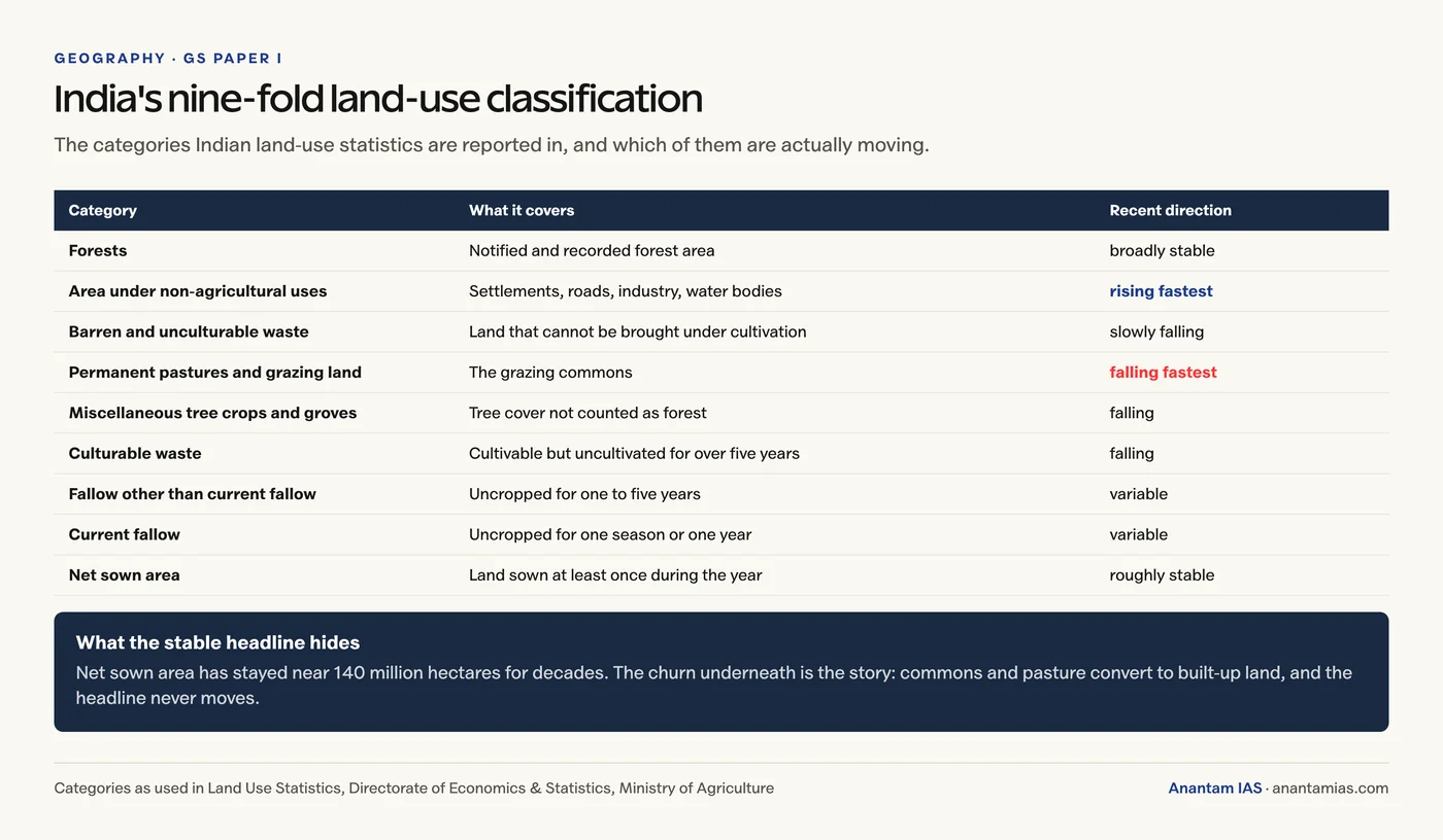
- Forests
- Area under non-agricultural uses (settlements, roads, industry, water bodies)
- Barren and unculturable waste
- Permanent pastures and other grazing land
- Land under miscellaneous tree crops and groves
- Culturable waste
- Fallow other than current fallow
- Current fallow
- Net sown area
The two categories shrinking fastest are permanent pastures and culturable waste, and both are commons. The category growing fastest is area under non-agricultural uses.
The Major Drivers
- Urbanisation and settlement expansion. India’s urban population is projected to approach 600 million by 2036, and peri-urban conversion of fertile land around Delhi-NCR, Bengaluru and Hyderabad is the fastest-moving frontier. See our note on urbanisation in India.
- Agricultural intensification. Canal and tubewell irrigation pushed cultivation into semi-arid tracts, while cropping shifted towards water-intensive paddy and sugarcane.
- Industry, mining and quarrying. Coal in the Jharkhand-Odisha-Chhattisgarh belt, iron ore at Bellary and Keonjhar, and sand mining along most major rivers.
- Infrastructure. Highways, dedicated freight corridors, ports, airports and hill roads. Linear projects fragment habitat far out of proportion to the area they occupy.
- Energy transition. Utility-scale solar and wind parks in Rajasthan, Gujarat and Karnataka now claim large blocks of common and pasture land.
- Policy and tenure. Land acquisition law, SEZ policy, compensatory afforestation that substitutes plantation for natural forest, and the classification of commons as “wasteland” available for allotment.
- Climate feedback. Coastal erosion, salinity ingress and Himalayan hazard exposure force change even where no development decision was taken.
Geographical Consequences
| Domain | Consequence |
|---|---|
| Hydrological | Higher runoff coefficients and reduced recharge, producing urban flooding (Chennai 2015, Bengaluru 2022) and falling water tables in over-extracted blocks |
| Ecological | Habitat fragmentation, broken wildlife corridors, rising human-wildlife conflict, biodiversity loss in the Western Ghats and Himalayan foothills |
| Geomorphic | Accelerated soil erosion, riverbed lowering and bank instability from sand mining, landslides on cut hill slopes, reservoir siltation |
| Climatic | Urban heat islands raising city temperatures several degrees above surrounding rural areas; altered albedo and evapotranspiration affecting local convection |
| Socio-spatial | Displacement and loss of commons for pastoralists and forest-dependent communities; informal settlements pushed onto the most hazard-prone land |
The Wetland Problem Specifically
Wetland loss deserves separate mention because it is the least visible and the most consequential for flood risk. Tanks and lakes that once absorbed monsoon peaks have been built over across peninsular India, and the flood events that follow are routinely described as unprecedented rainfall when they are in fact ordinary rainfall meeting a vanished detention system. The regulatory frame is the Wetland (Conservation and Management) Rules, 2017, and the international one is the Ramsar Convention, covered in our note on Ramsar sites in India.
Governance Instruments
- Forest (Conservation) Act and CAMPA for diversion and compensatory afforestation.
- Coastal Regulation Zone notifications for the coastal strip.
- Wetland (Conservation and Management) Rules, 2017.
- Master plans and development control rules at city level, plus land-pooling models such as the Rajasthan model.
- India’s land degradation neutrality target and the Bonn Challenge pledge to restore 26 million hectares by 2030.
- ISRO’s national land-use and land-cover mapping, which supplies the evidence base.
The Real Constraint
Instruments exist. What does not exist at the required scale is spatial planning capacity at district and municipal level. Master plans are frequently outdated, poorly enforced or absent entirely, and ecological function is not priced into any land transaction. Until planning operates at the same scale as the drivers, each sectoral gain will keep being offset by a hydrological or ecological loss recorded somewhere else.
Frequently Asked Questions
What is land-use change?
It is the conversion of land from one use to another, such as cropland to settlement, forest to plantation, or wetland to built-up area. In India it is measured through the nine-fold land-use classification and through ISRO’s land-use and land-cover mapping.
What is the nine-fold land-use classification in India?
Forests; area under non-agricultural uses; barren and unculturable waste; permanent pastures and grazing land; land under miscellaneous tree crops and groves; culturable waste; fallow other than current fallow; current fallow; and net sown area.
Why has India’s net sown area stayed roughly constant?
Because losses to settlement and infrastructure have been offset by bringing culturable waste, fallow and pasture into cultivation. The stable aggregate hides a large internal churn, and the categories shrinking fastest are commons such as permanent pasture.
How does land-use change cause urban flooding?
Replacing permeable soil and vegetation with impervious surfaces raises the runoff coefficient and cuts groundwater recharge, so more rain becomes surface flow. When wetlands and tanks that once absorbed monsoon peaks are also built over, the natural detention capacity disappears and ordinary rainfall produces extraordinary flooding.
What is an urban heat island?
It is the effect where built-up areas record temperatures several degrees higher than surrounding rural areas, because concrete and asphalt absorb and re-radiate heat, vegetation cover that would cool through evapotranspiration is removed, and waste heat is added by vehicles and air conditioning.
What is the main obstacle to managing land-use change in India?
Not the absence of instruments but the absence of spatial planning capacity at district and municipal level. Master plans are often outdated or unenforced, commons are weakly protected in law, and the ecological function of land is not priced into land transactions.
Practice Questions
Prelims MCQs
1. Which land-use category has grown fastest in India in recent decades?
- (a) Net sown area
- (b) Permanent pastures
- (c) Area under non-agricultural uses
- (d) Culturable waste
Answer: (c) Area under non-agricultural uses
2. India supports approximately what share of the world’s population on 2.4 per cent of its land area?
- (a) 12 per cent
- (b) 15 per cent
- (c) 18 per cent
- (d) 22 per cent
Answer: (c) 18 per cent
3. The Wetland (Conservation and Management) Rules were notified in:
- (a) 2010
- (b) 2016
- (c) 2017
- (d) 2020
Answer: (c) 2017
4. An urban heat island is primarily caused by:
- (a) Higher rainfall in cities
- (b) Impervious surfaces, loss of vegetation and waste heat
- (c) Greater altitude of urban areas
- (d) Increased wind speed in built-up areas
Answer: (b) Impervious surfaces, loss of vegetation and waste heat
5. CAMPA in the context of land-use change relates to:
- (a) Coastal zone management
- (b) Compensatory afforestation fund management
- (c) Command area development
- (d) Crop area monitoring
Answer: (b) Compensatory afforestation fund management
Mains Questions
- Analyze the major drivers of human-induced land-use changes in India and their geographical consequences.
- “India’s urban flooding is a land-use problem before it is a rainfall problem.” Examine.
- Discuss the impact of the renewable energy transition on common and pasture land in India.
- Examine the adequacy of India’s spatial planning framework in regulating land-use change.
- Assess the ecological consequences of linear infrastructure projects in ecologically sensitive regions of India.
Tell Google you want more of this.
Add Anantam IAS as a preferred sourceOne tap, and this site shows up more often in your own Top Stories, AI Overviews and AI Mode. Remove it any time.