

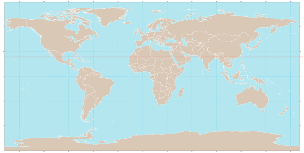
The Tropic of Cancer is an imaginary line of latitude at approximately 23°26' North of the Equator. It marks the northernmost point at which the sun can appear directly overhead at noon (during the summer solstice, around June 21). In India, it passes through 8 states — a fact that is one of the most frequently tested geography questions in UPSC Prelims.
Understanding the Tropic of Cancer is not just about memorising which states it crosses. It divides India into two distinct climatic zones and has direct implications for agriculture, rainfall patterns, and temperature distribution.
What Is the Tropic of Cancer?
The Earth's axis is tilted at approximately 23.5° relative to its orbital plane. Because of this tilt:
- On the summer solstice (June 21), the sun is directly overhead at 23°26'N — the Tropic of Cancer
- On the winter solstice (December 22), the sun is directly overhead at 23°26'S — the Tropic of Capricorn
- The region between these two lines is the Tropics (tropical zone)
The Tropic of Cancer gets its name from the constellation Cancer. When the line was named over 2,000 years ago, the sun was in the constellation Cancer during the summer solstice. Due to axial precession, this is no longer the case, but the name persists.
Current latitude: 23°26'11.7" N (this shifts slightly over a 40,000-year cycle).
Tropic of Cancer in India: 8 States
The Tropic of Cancer enters India from the Rann of Kutch in the west and exits through Mizoram in the east. It passes through 8 states in the following west-to-east order:
| # | State | Region/District It Passes Through | Notable Feature |
|---|---|---|---|
| 1 | Gujarat | Rann of Kutch, Mehsana, Sabarkantha | Enters India from Pakistan border |
| 2 | Rajasthan | Banswara, Dungarpur | Passes through southern Rajasthan |
| 3 | Madhya Pradesh | Shajapur, Bhopal, Jabalpur, Amarkantak | Longest stretch — passes through the state capital Bhopal |
| 4 | Chhattisgarh | Korba, Surguja | Crosses the northern part of the state |
| 5 | Jharkhand | Ranchi | Passes near the state capital |
| 6 | West Bengal | Bankura, Purulia, Nadia | Crosses the western districts |
| 7 | Tripura | Central Tripura | Only northeastern state other than Mizoram |
| 8 | Mizoram | Aizawl | Passes near the state capital; exits India |
Mnemonic for Remembering
"Gu-Ra-Ma-Cha-Jha-We-Tri-Mi" — Gujarat, Rajasthan, Madhya Pradesh, Chhattisgarh, Jharkhand, West Bengal, Tripura, Mizoram.
Another popular mnemonic: "Go Right, My Child, Just Walk To Mizoram"
Key UPSC trap: The Tropic of Cancer does NOT pass through Odisha, Maharashtra, Bihar, Assam, Meghalaya, or Manipur. These are common wrong options in Prelims.
Note: Madhya Pradesh has the longest stretch of the Tropic of Cancer of any Indian state. It is literally the "middle province" — and the Tropic of Cancer roughly bisects it.
Climatic Significance
The Tropic of Cancer divides India into two broad climatic zones:
North of the Tropic (Subtropical Zone)
- Experiences greater temperature variation between summer and winter
- Receives more winter rainfall (Western Disturbances)
- Continental climate characteristics — hot summers, cool/cold winters
- Includes the Indo-Gangetic Plain, Thar Desert, and Himalayan region
South of the Tropic (Tropical Zone)
- Less temperature variation — relatively warm throughout the year
- Maritime influence moderates temperatures
- Receives predominantly monsoon rainfall
- Includes the Deccan Plateau, Western and Eastern Ghats, and coastal plains
| Parameter | North of Tropic of Cancer | South of Tropic of Cancer |
|---|---|---|
| Temperature range | High (10–45°C in some regions) | Moderate (20–38°C typically) |
| Winter temperatures | Can drop below 5°C (north plains) | Rarely below 15°C (except high altitude) |
| Rainfall pattern | Monsoon + Western Disturbances | Predominantly monsoon |
| Vegetation | Tropical dry deciduous to temperate | Tropical wet/dry to tropical evergreen |
| Agriculture | Wheat, mustard (Rabi); rice, sugarcane (Kharif) | Rice, coconut, spices, rubber, tea |
Sun's Position and Seasons
- During the summer solstice (June 21), the sun is directly overhead on the Tropic of Cancer. Locations along this line experience the sun at zenith (90° altitude).
- This creates the peak heating belt, which drives the monsoon mechanism — the ITCZ (Inter-Tropical Convergence Zone) shifts northward, pulling moisture-laden winds from the Indian Ocean.
Tropic of Cancer vs. Tropic of Capricorn
| Feature | Tropic of Cancer | Tropic of Capricorn |
|---|---|---|
| Latitude | 23°26' N | 23°26' S |
| Hemisphere | Northern | Southern |
| Sun overhead | Summer solstice (~June 21) | Winter solstice (~December 22) |
| Passes through India? | Yes (8 states) | No |
| Major countries | India, China, Mexico, Egypt, Saudi Arabia, Myanmar, Bangladesh | Australia, Brazil, South Africa, Chile, Madagascar |
| Named after | Constellation Cancer | Constellation Capricorn |
Countries the Tropic of Cancer Passes Through
The Tropic of Cancer passes through 16 countries (and Western Sahara territory):
Africa: Western Sahara, Mauritania, Mali, Algeria, Niger, Libya, Chad, Egypt
Asia: Saudi Arabia, UAE, Oman, India, Bangladesh, Myanmar, China (including Taiwan)
North America: Mexico, Bahamas (maritime)
Key fact for UPSC: The Tropic of Cancer passes through the maximum number of countries in Africa.
Five Key Latitudes and Longitudes for India
For context, here are the important reference lines for India:
| Line | Position | Significance |
|---|---|---|
| Tropic of Cancer | 23°26' N | Divides India into tropical and subtropical zones |
| Standard Meridian | 82°30' E | India's standard time reference (passes through Mirzapur, UP) |
| Northern extent | ~37°6' N | Indira Col (northernmost point of India) |
| Southern extent | ~6°45' N | Indira Point, Great Nicobar (southernmost point) |
| Mainland southern tip | ~8°4' N | Kanyakumari (Cape Comorin) |
UPSC Map-Based Tips
The Tropic of Cancer is a favourite for map-based questions. Here's how it appears:
- Direct question: "Which of the following states does the Tropic of Cancer NOT pass through?" — Memorise the 8 states; eliminate wrong options.
- Indirect climate questions: "Which of the following factors contributes to the subtropical climate of the Indo-Gangetic Plain?" — The Tropic of Cancer's position explains why north India has a subtropical (not tropical) climate.
- Agriculture connections: Questions linking crop patterns to climatic zones divided by the Tropic of Cancer.
- Trick questions: States the Tropic passes "near" but not "through" — Odisha and Maharashtra are close but not crossed.
Quick Revision Box
- Latitude: 23°26' N
- 8 Indian states (W→E): Gujarat, Rajasthan, Madhya Pradesh, Chhattisgarh, Jharkhand, West Bengal, Tripura, Mizoram
- Longest stretch: Madhya Pradesh
- Divides India into: Tropical (south) and Subtropical (north)
- Sun overhead: June 21 (Summer Solstice)
- Total countries crossed: 16
- Named after: Constellation Cancer
- Added by 42nd Amendment? No — that's the Preamble. Don't confuse your revision topics!
Tell Google you want more of this.
Add Anantam IAS as a preferred sourceOne tap, and this site shows up more often in your own Top Stories, AI Overviews and AI Mode. Remove it any time.






