

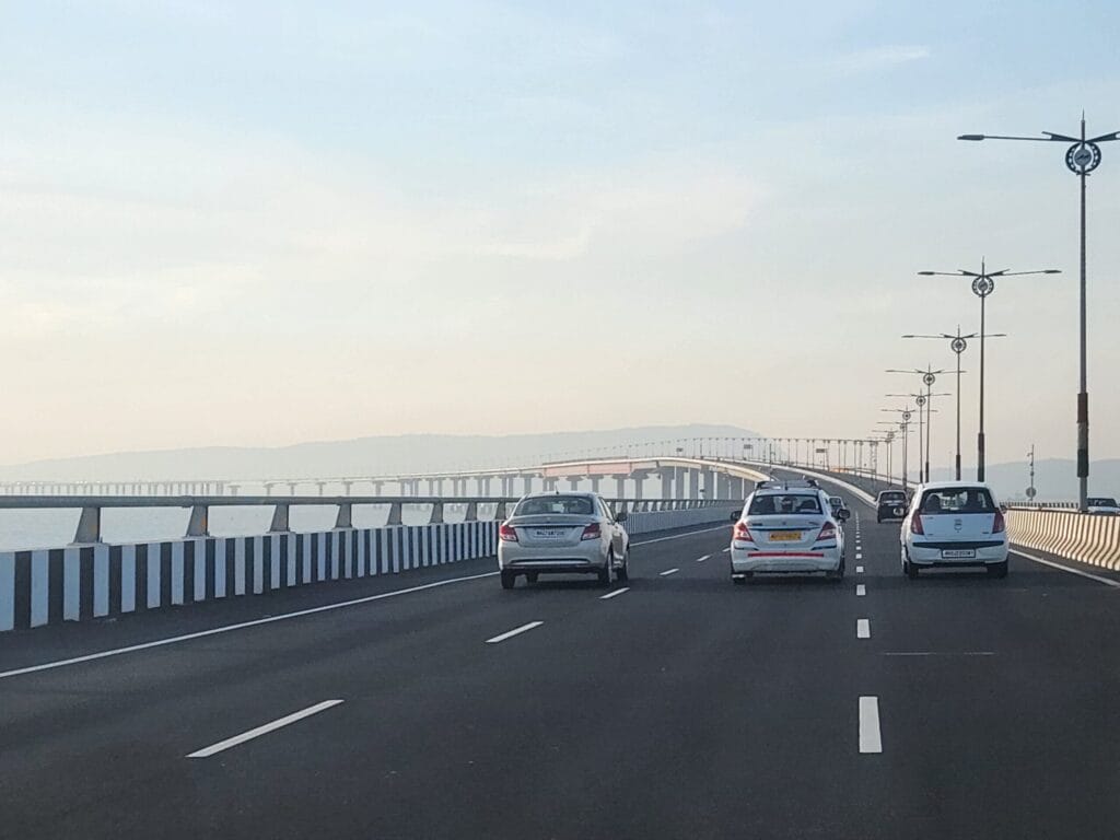
Atal Setu — officially the Atal Bihari Vajpayee Sewri-Nhava Sheva Atal Setu, also called the Mumbai Trans Harbour Link (MTHL) — is India's longest sea bridge and one of the longest sea bridges in the world. The 22 km bridge connects Sewri in South Mumbai with Chirle near Nhava Sheva in Navi Mumbai, dramatically reducing travel time between Mumbai and the satellite city.
The bridge was inaugurated on January 12, 2024 by Prime Minister Narendra Modi and named after former PM Atal Bihari Vajpayee.
For UPSC, Atal Setu appears in Economy (GS3 — infrastructure), Geography (Mumbai region), and Governance (PPP project execution).
Key Facts
| Aspect | Detail |
|---|---|
| Official name | Atal Bihari Vajpayee Sewri-Nhava Sheva Atal Setu |
| Common name | Mumbai Trans Harbour Link (MTHL); Atal Setu |
| Length | 21.8 km (16.5 km over sea + 5.5 km over land) |
| Cost | ~Rs. 17,840 crore |
| Type | 6-lane sea bridge (3 lanes each direction) |
| Connects | Sewri (Mumbai Island) to Chirle near Nhava Sheva (Navi Mumbai) |
| Inaugurated | January 12, 2024 |
| Inaugurated by | PM Narendra Modi |
| Implementing agency | Mumbai Metropolitan Region Development Authority (MMRDA) |
| Funded by | Japan International Cooperation Agency (JICA) loan + state contributions |
| Construction period | ~2018-2024 |
| Speed limit | 100 km/h (cars); 80 km/h (heavy vehicles) |
| Toll (one-way) | Rs. 250 (cars) at launch |
Background: Need for the Bridge
Mumbai's Geographic Constraint
Mumbai is built on a series of islands that have been progressively connected by causeways and reclaimed land. The city's geographic constraints have always been:
- Limited horizontal expansion — surrounded by sea on three sides
- Heavy traffic congestion
- Long commute times within the metropolitan region
- Need to develop satellite cities (Navi Mumbai, Thane)
Existing Routes to Navi Mumbai
Before MTHL, the main routes between Mumbai and Navi Mumbai were:
- Sion-Panvel Highway — heavy traffic, frequent congestion
- Vashi Bridge — over Thane Creek; congested
- Eastern Freeway + Vashi route — limited capacity
A trip from South Mumbai to Navi Mumbai/Nhava Sheva could take 2-3 hours during peak traffic. MTHL reduces this to 20-25 minutes.
Strategic Importance
Beyond commute reduction, MTHL serves several strategic purposes:
- Connectivity to Jawaharlal Nehru Port (JNPT) — India's largest container port (located near Nhava Sheva)
- Access to upcoming Navi Mumbai International Airport (under construction)
- Connection to Mumbai-Pune Expressway through Navi Mumbai
- Eastern dispersal route reducing pressure on Mumbai's roads
Technical Features
Structural Engineering
| Feature | Detail |
|---|---|
| Total length | 21.8 km |
| Sea section | 16.5 km (over Thane Creek/Mumbai Harbour) |
| Land approaches | 5.5 km |
| Width | ~27 m |
| Lanes | 6 (3 each direction) |
| Foundation | Pile foundations sunk into sea bed |
| Span types | Mix of orthotropic steel decks and concrete sections |
| Maximum span | 180 m (over the navigation channel) |
| Height clearance | Sufficient for naval and commercial ships |
Bridge Sections
The bridge has multiple engineering sections:
- Sewri end approach (Mumbai side)
- Mid-sea section (over Thane Creek, with views of Mumbai harbour)
- Navigation channel section (with cable-stayed-style spans for ship clearance)
- Chirle/Nhava Sheva approach (Navi Mumbai side)
Environmental Considerations
The MTHL passes near or over:
- Sewri-Mahul mudflats — important bird habitat (especially Greater Flamingos that visit Mumbai annually)
- Mangrove patches along the coast
- Marine ecosystem of Mumbai harbour
Environmental measures included:
- Avoiding direct construction over the most sensitive flamingo areas
- Special design to minimise pile-driving impact on marine life
- Replanting of mangroves where construction caused damage
However, environmental groups continue to raise concerns about long-term impacts on the flamingo habitat and marine ecosystem.
Construction Challenges
Engineering Challenges
| Challenge | Solution |
|---|---|
| Sea-bed conditions | Detailed geological surveys; specialised pile foundations |
| Tidal variations | Construction phases adjusted to tide patterns |
| Ship traffic | Construction methods designed not to disrupt port operations |
| Cyclone season | Construction halted during monsoon high winds |
| Welding underwater segments | Specialised orthotropic deck assembly |
Project Management
The project was implemented through:
- JICA loan for ~85% of the cost (~Rs. 15,109 crore)
- State government contributions
- EPC (Engineering, Procurement, Construction) contracts with consortia of Indian and foreign companies
- MMRDA as implementing agency
- L&T, IHI, Daewoo, and other companies as construction contractors
Economic Impact
Direct Benefits
| Benefit | Estimate |
|---|---|
| Commute time reduction | Mumbai-Navi Mumbai: 2 hours → 20 minutes |
| Fuel savings | Estimated ~50% reduction in fuel consumption per trip |
| Annual traffic | Expected ~70,000 vehicles per day in early years; ~1 lakh+ at full capacity |
| Carbon emissions | Significant reduction due to shorter routes |
Property Market Impact
The MTHL has accelerated real estate development in Navi Mumbai:
- Property prices in Ulwe, Karanjade, and Panvel areas have risen significantly
- Commercial development along the access roads
- Industrial corridors linked to the bridge
Port Logistics
For Jawaharlal Nehru Port (JNPT) — India’s largest container port, handling ~50% of India’s container traffic:
- Faster container movement to Mumbai industries
- Reduced truck delays at existing routes
- Better integration with Mumbai's distribution networks
World's Longest Sea Bridges (Context)
| Rank | Bridge | Length | Country | Year |
|---|---|---|---|---|
| 1 | Hong Kong-Zhuhai-Macau Bridge | 55 km | China | 2018 |
| 2 | Hangzhou Bay Bridge | 36 km | China | 2008 |
| 3 | East Sea Grand Bridge | 32.5 km | China | 2005 |
| 4 | Donghai Bridge | 32.5 km | China | 2005 |
| 5 | Atal Setu (MTHL) | 21.8 km | India | 2024 |
While Atal Setu is not the world's longest sea bridge, it is India's longest by a significant margin — the previous longest was the Bandra-Worli Sea Link (also in Mumbai) at 5.6 km.
Other Major Indian Sea Bridges
| Bridge | Length | Location | Year |
|---|---|---|---|
| Atal Setu (MTHL) | 21.8 km | Mumbai | 2024 |
| Pamban Bridge | 2 km | Tamil Nadu (rail/road) | 1914 (rail); 1988 (road) |
| Bandra-Worli Sea Link | 5.6 km | Mumbai | 2009 |
| Bogibeel Bridge | 4.94 km | Assam (Brahmaputra; rail-cum-road) | 2018 |
| Bhupen Hazarika Setu (Dhola-Sadiya Bridge) | 9.15 km | Assam-Arunachal | 2017 |
The Dhola-Sadiya Bridge is India's longest river bridge; Atal Setu is the longest sea bridge.
UPSC Relevance
GS3 (Economy): Infrastructure development, transportation, urban connectivity.
GS1 (Geography): Mumbai region, coastal infrastructure.
GS2 (Governance): PPP/government projects, large infrastructure execution.
Key Prelims facts:
- Official name: Atal Bihari Vajpayee Sewri-Nhava Sheva Atal Setu
- Common name: MTHL (Mumbai Trans Harbour Link)
- Length: 21.8 km (longest sea bridge in India)
- Sea section: 16.5 km
- Connects: Sewri (Mumbai) to Chirle (Navi Mumbai)
- Inaugurated: January 12, 2024
- Inaugurated by: PM Narendra Modi
- Cost: ~Rs. 17,840 crore
- Major funder: JICA (Japan International Cooperation Agency)
- Implementing agency: MMRDA
- Lanes: 6 (3 each direction)
- Speed limit: 100 km/h (cars)
- Toll (cars, one-way at launch): Rs. 250
- Travel time reduction: 2 hours to 20 minutes (Mumbai-Navi Mumbai)
- Connects to: JNPT, Mumbai-Pune Expressway, future Navi Mumbai Airport
- Previous longest sea bridge in India: Bandra-Worli Sea Link (5.6 km)
Tell Google you want more of this.
Add Anantam IAS as a preferred sourceOne tap, and this site shows up more often in your own Top Stories, AI Overviews and AI Mode. Remove it any time.






