Disclosure: this guide contains Amazon affiliate links. As an Amazon Associate, Anantam IAS earns from qualifying purchases — at no extra cost to you.
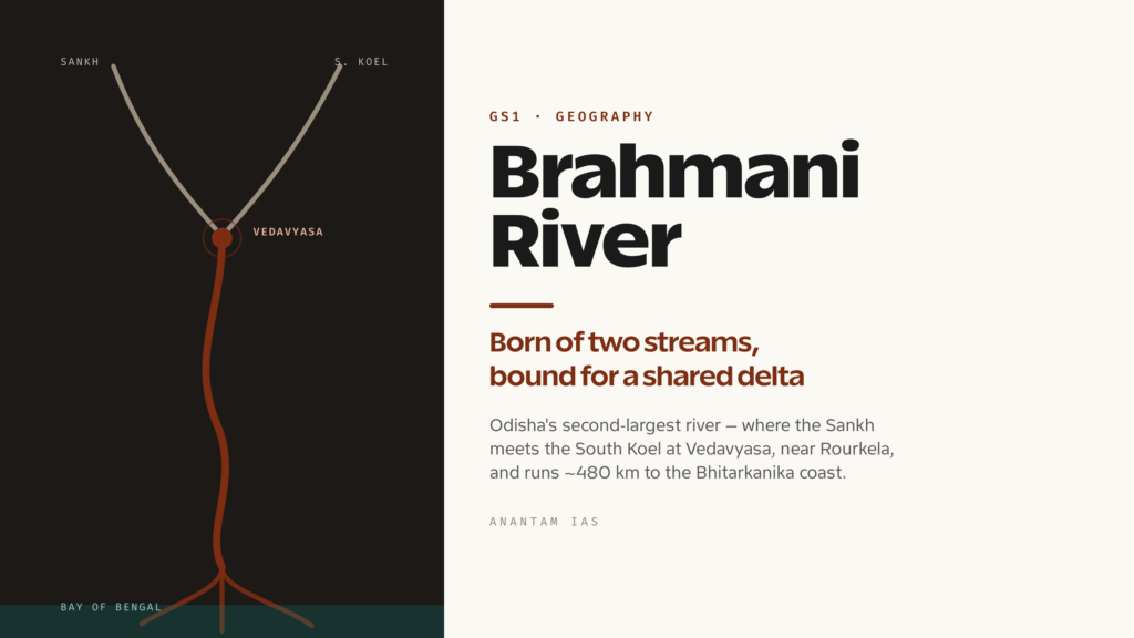
The Brahmani begins not at a spring but at a handshake. Two plateau rivers — the Sankh from the west and the South Koel from the south — run down off the Chhotanagpur uplands and meet at a small spot called Vedavyasa, just outside the steel town of Rourkela. Below that meeting point the combined stream takes a new name and becomes Odisha’s second-largest river, after the Mahanadi. From there it crosses the state diagonally, picks up the runoff of one of the densest mining and industrial belts in India, and finally fans out into a shared delta where saltwater crocodiles bask and Olive Ridley turtles come ashore by the lakh.
That arc — from a quiet plateau confluence to a contested, heavily worked, ecologically priceless estuary — is exactly why the Brahmani keeps turning up in UPSC papers. It’s a peninsular east-flowing river you can be asked to identify by its source confluence. It’s a case study in how industry and a river basin collide. And it’s the freshwater lifeline of the Bhitarkanika mangroves, the second-largest mangrove system in the country. Get its anatomy right once and you’ve stocked answers for both GS-I geography and GS-III environment.
Source and Course: A River Born of Two
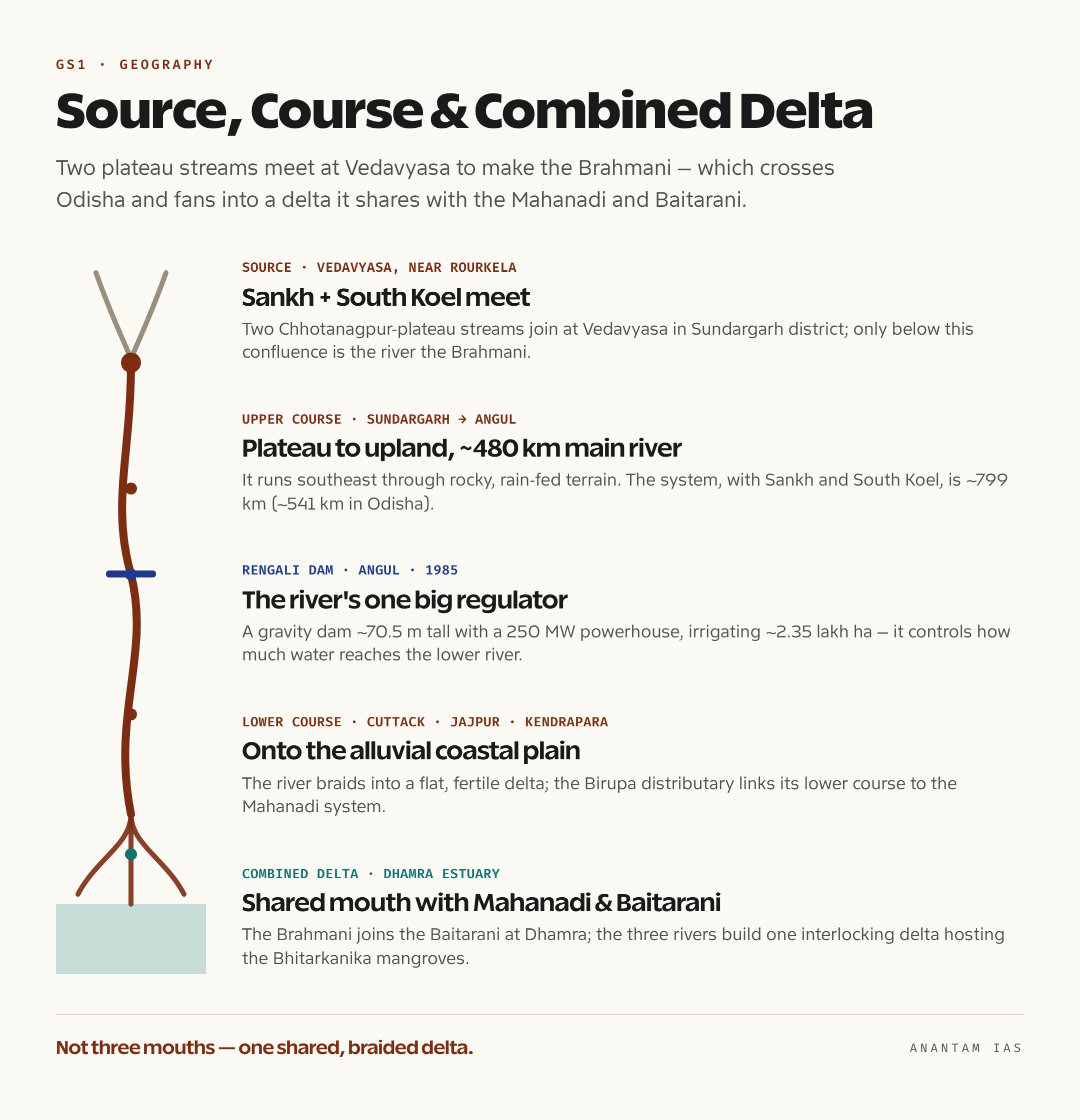
The Brahmani has no single point of origin, and that’s the first thing to fix in memory. It’s a composite river, formed by the meeting of two headwater streams that each rise on the Chhotanagpur plateau in Jharkhand. The Sankh rises in the Gumla-Netarhat uplands near the Jharkhand-Chhattisgarh border. The South Koel rises from the same plateau country near Lohardaga. They flow down through forested, undulating terrain and join at Vedavyasa (also written Veda Vyasa), close to Rourkela in Odisha’s Sundargarh district. Only below this confluence is the river called the Brahmani.

Oxford Student Atlas for India — 7th Edition
- 160 pages, Oxford University Press, the current edition
- India-focused thematic maps: physical, political, rivers, climate, soils, vegetation, plus world maps
- Made for UPSC and state PSC map work; slim enough to stay open beside the textbook
How long is it? This is where you have to be precise, because different sources quote different numbers and an examiner can exploit the gap. The Brahmani proper — measured from Vedavyasa to the sea — runs roughly 480 kilometres. But if you count the river along with its constituent Sankh and South Koel, the system runs about 799 kilometres, of which around 541 kilometres lie inside Odisha. So both figures are “right”; they just measure different things. The safe phrasing for an answer is that the Brahmani system is about 799 km long, the main river below the confluence about 480 km.
From Vedavyasa the river flows broadly southeast, threading through Sundargarh, Deogarh, Angul, Dhenkanal, Cuttack, Jajpur and Kendrapara districts. It descends from the eastern plateau onto undulating uplands and finally onto the alluvial coastal plain. The early reaches are rocky and rain-fed; the lower reaches braid into a flat, fertile delta. And because the whole river is monsoon-dependent, it swings hard between a flood-prone wet season and a thin, stressed lean season — a seasonality that shapes everything from its dams to its mangroves.
Tributaries and Basin: Plateau to Coast
The Brahmani basin spreads across parts of Jharkhand, Chhattisgarh and Odisha, but the bulk of the catchment sits in Odisha. The total basin is roughly 39,000 square kilometres. Apart from its two headwater founders, the river is fed by several tributaries that drain the mineral-rich Keonjhar-Sundargarh belt.
| Tributary | Side | Note |
|---|---|---|
| Sankh | Headwater | Joins the South Koel at Vedavyasa to form the Brahmani |
| South Koel | Headwater | Rises near Lohardaga on the Chhotanagpur plateau |
| Tikra | Right bank | Joins in the upper reaches |
| Karo | Left bank | Drains the iron-ore mining belt of Keonjhar |
| Nandira Jhor | Right bank | Flows past the Talcher-Angul industrial zone |
| Birupa | Distributary link | Connects the Brahmani’s lower course with the Mahanadi system |
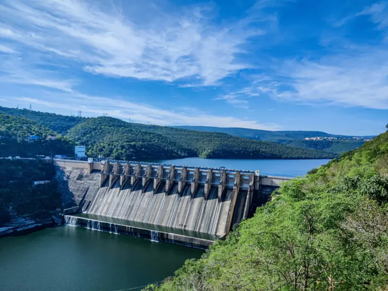
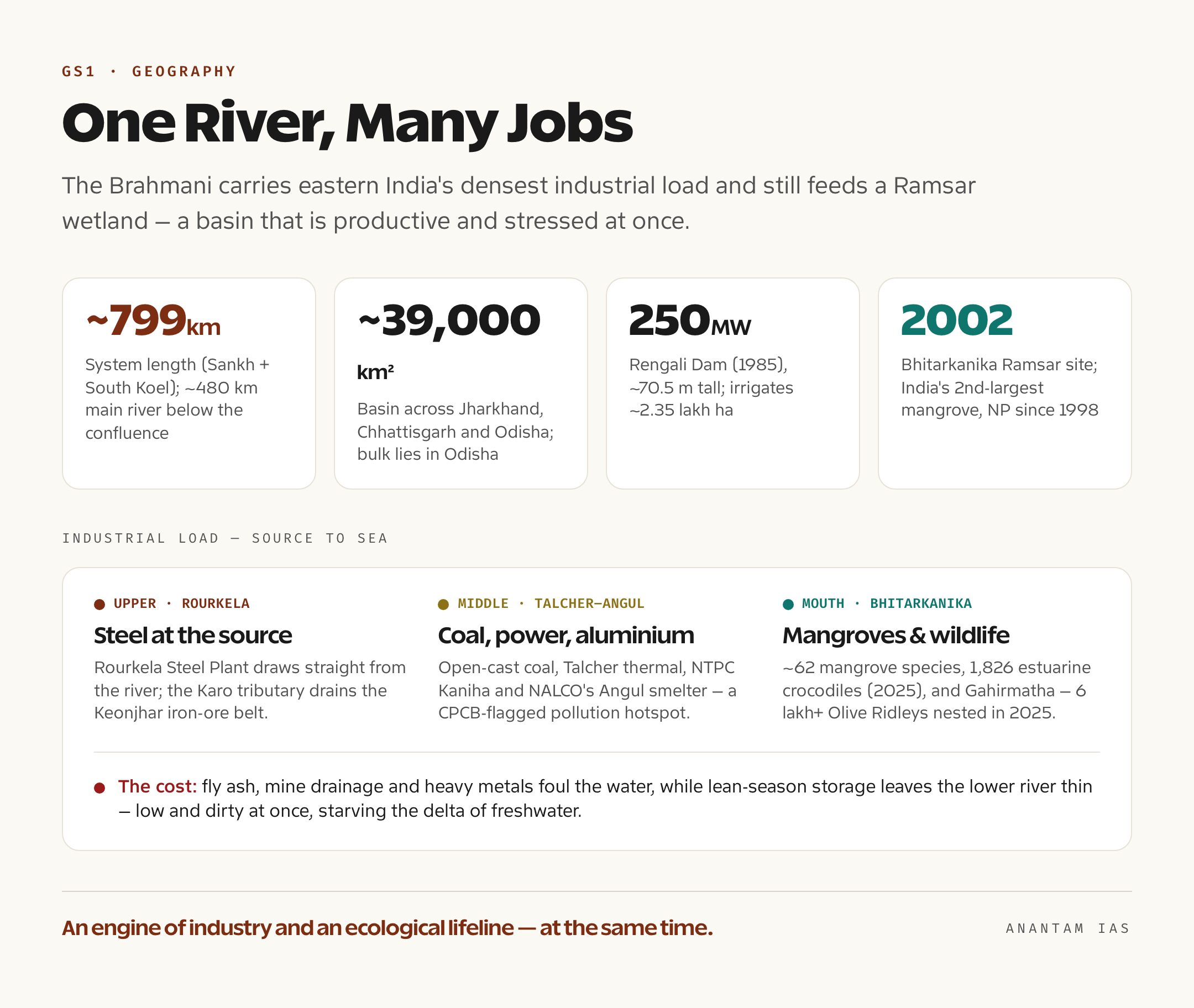
Two features define the basin’s physical story. The first is the plateau-to-coast gradient: hard rock and forest upstream, alluvium and estuary downstream, which is why the upper basin is about mining and power and the lower basin is about agriculture and mangroves. The second is the Rengali Dam, the river’s single biggest structure, built across the Brahmani near Rengali village in Angul district and commissioned in 1985. It’s a multipurpose gravity dam about 70.5 metres tall and over a kilometre wide, with a powerhouse rated at 250 MW (five units of 50 MW each). Its reservoir is among the largest in Odisha and is designed for flood moderation, irrigation across roughly 2.35 lakh hectares, and hydropower. Because the dam regulates how much water reaches the lower river, it sits at the centre of every downstream argument — about farming, about pollution dilution, and about the delta.
So why does this basin matter out of proportion to its size? Because it does an extraordinary number of jobs at once. The same river that supplies the Rourkela Steel Plant near its source also irrigates central Odisha through the Rengali canal command, supplies drinking water to Rourkela, Angul and the delta towns, carries away the effluent of a national coal-and-power hub, and finally feeds the freshwater that keeps the Bhitarkanika mangroves alive. Few Indian rivers compress so many competing demands into so short a course. And the basin’s location on the cyclone-prone Odisha coast adds a final layer: the delta’s mangroves are a natural storm shield for lakhs of people, which means the Brahmani’s flow isn’t just an economic question, it’s a disaster-resilience one.
The Combined Delta and Bhitarkanika
Near the coast the Brahmani does something unusual: it doesn’t reach the sea alone. It splits into distributaries — the Kharsuan and Kimiria branches among them — and merges with the Baitarani to discharge through the Dhamra estuary, while the larger Mahanadi delta sits immediately alongside. The result is one of India’s biggest combined deltas, where the Mahanadi, Brahmani and Baitarani build a single, braided coastal plain on the northern Odisha coast. This is the detail that catches candidates out: people picture three separate mouths, when the reality is a shared, interlocking deltaic system.
That delta hosts the Bhitarkanika mangroves, the second-largest mangrove ecosystem in India after the Sundarbans, with around 62 mangrove species recorded. Its core was declared Bhitarkanika National Park in 1998, and the wetland was listed as a Ramsar site of international importance in 2002. Bhitarkanika holds the country’s highest density of saltwater crocodiles — the 2025 reptile census counted 1,826 estuarine crocodiles, including a handful of rare albinos — and it shelters a huge population of estuarine birds.
And just offshore lies the reason the world watches this coast. Gahirmatha, the beach fronting Bhitarkanika in Kendrapara district, is the largest known nesting ground on the planet for Olive Ridley sea turtles. Each year, between roughly January and March, the turtles gather for the arribada — the mass synchronised nesting when hundreds of thousands come ashore in a few days. In the 2025 season more than six lakh turtles nested at Gahirmatha over a five-day window. But the event is fragile and irregular: in some years the turtles barely show, a swing linked to changing sea conditions, beach erosion and the freshwater balance of the estuary — which is where the Brahmani’s lean-season flow comes back into the story.
The delta also carries weight as infrastructure and as buffer. The Dhamra port, near the Brahmani-Baitarani mouth, gives Odisha a deep-water gateway for its mineral and steel exports — but it sits right beside the Gahirmatha Marine Sanctuary, so every expansion reopens the same growth-versus-conservation question the basin keeps posing. And the mangroves themselves are a hard, measurable asset: when Cyclone Bhitarkanika-belt storms make landfall, the dense forest absorbs the surge and shields the farming villages behind it. That protective service depends on the river continuing to push enough freshwater into the estuary to keep the mangroves healthy — a quiet link between an inland dam and the safety of the coast.
Industry, Pollution and a Stressed River
The Brahmani basin carries one of the most concentrated industrial loads of any river in eastern India, and the river pays for it. Walk the basin from top to bottom and you pass almost the full menu of heavy industry. Near the source sits the Rourkela Steel Plant, the public-sector steelworks that draws water straight from the river. In the middle basin lies the Talcher-Angul cluster — open-cast coal mines, the Talcher thermal power station, NTPC’s large station at Kaniha, and NALCO’s aluminium smelter at Angul. The Karo tributary drains the iron-ore belt of Keonjhar. Add the drinking-water demand of Rourkela, Angul and the delta towns, and you have a river asked to do everything at once.
The cost shows up in water quality. The Central Pollution Control Board has repeatedly flagged the Brahmani — particularly the stretches around Rourkela and downstream of Talcher — as polluted, and the Talcher-Angul area is treated as an industrial-pollution hotspot. The sources are textbook: fly ash sluiced from thermal stations, mine drainage and heavy-metal contamination (studies have found lead well above safe drinking limits in places), effluents from steel and aluminium works, and untreated urban sewage. On top of pollution sits a quantity problem. In the dry months, upstream storage at Rengali plus diversion and siltation leave the lower river thin — and a river that’s both low and dirty is the worst combination, because there’s too little clean water to dilute the load. That same lean flow is what starves the delta, pushing saline water further inland and stressing the very mangroves that protect this cyclone-battered coast.
Way Forward: Sharing, Cleaning, Protecting
The Brahmani’s problems are solvable, but only if the basin is managed as one connected system rather than a string of separate permits. Three priorities stand out.
The first is integrated basin governance. Because the river is shared between Jharkhand and Odisha, and because its lower course is linked to the Mahanadi through the Birupa, the long-discussed idea of a Brahmani-Baitarani river basin authority matters — a single body to plan flows, reconcile upstream storage with downstream needs, and guarantee an environmental flow in the lean season so the delta and Bhitarkanika don’t run dry. The second is pollution abatement with teeth: enforcing zero-liquid-discharge at the big steel, aluminium and thermal plants, fixing fly-ash handling, and building sewage treatment for the basin towns, backed by the kind of monitoring the CPCB and National Green Tribunal can act on rather than just record. The third is coastal and ecological protection — restoring eroding mangrove buffers, controlling sand mining in the middle reaches, and managing the estuary’s freshwater-saltwater balance so that crocodiles, turtles and the delta’s farming villages can all survive the next cyclone. None of this is exotic. It’s the standard toolkit of sustainable river management; the Brahmani simply shows why using it is urgent.
For Your Mains Answer
The Brahmani is a flexible peg for GS Paper 1 (Indian and world geography — drainage systems, deltaic landforms) and especially for GS Paper 3 (environment, pollution, conservation, and infrastructure-ecology trade-offs). It also works in interview and essay contexts on “development versus environment.” Treat it as a case study: a single river that demonstrates how a basin can be productive and degraded at the same time.
How to Build the Answer
Open with the river’s anatomy — composite source at Vedavyasa, course through Odisha, combined delta — then pivot quickly to the tension that makes it examinable: heavy industry upstream, a fragile Ramsar wetland downstream, and a lean-season flow caught between them. Move from facts to argument: describe the use, name the pollution, then propose basin-level fixes. Close on the development-versus-ecology balance rather than a one-sided lament.
Common Mistakes to Avoid
Don’t confuse the Brahmani’s two length figures — say clearly that the system is ~799 km and the main river below the confluence ~480 km. Don’t write that it has a single source; it’s formed by the Sankh and South Koel. Don’t separate the three deltas — the Mahanadi, Brahmani and Baitarani build a combined delta. And don’t reduce Bhitarkanika to “a forest”; it’s a national park, Ramsar site and the Gahirmatha turtle rookery in one.
A Compact Answer Spine
Sankh + South Koel meet at Vedavyasa near Rourkela → Brahmani, Odisha’s second-largest river (~799 km system) → flows through Sundargarh to the coast → Rengali Dam (250 MW, irrigation, flood control) → combined delta with Mahanadi and Baitarani via the Dhamra estuary → Bhitarkanika mangroves and Gahirmatha turtles → heavy industry (Rourkela steel, Talcher-Angul power and aluminium) → CPCB-flagged pollution + lean-season stress → way forward: basin authority, environmental flow, pollution control, mangrove protection.
Diagram or Flowchart Idea
Draw the river as a single line from a forked top (Sankh and South Koel joining at Vedavyasa) down to a delta that interlocks with two neighbouring rivers. Pin three labels along it: “Rourkela — steel” near the top, “Talcher-Angul — coal, power, aluminium” in the middle, and “Bhitarkanika — mangroves, crocodiles, turtles” at the mouth. That one sketch carries source, course, use and ecology together.
A Balanced-Conclusion Line
The Brahmani shows that a river can be an engine of industrial growth and an ecological lifeline at once — and that the test of good governance is making the two coexist, by guaranteeing clean water and a living delta even while the steel and power keep running.
How to Use Data Without Cramming
You need only a few anchors: ~799 km system / ~480 km main river, basin ~39,000 sq km, Rengali Dam 250 MW commissioned 1985, Bhitarkanika a 2002 Ramsar site and India’s second-largest mangrove, and Gahirmatha’s six-lakh-plus turtle arribada in 2025. Drop two or three of these, not all of them, and let the argument carry the rest.
FAQ
How is the Brahmani River formed and where? It’s a composite river formed by the confluence of the Sankh and South Koel rivers at Vedavyasa, near Rourkela in Odisha’s Sundargarh district. Both headwater streams rise on the Chhotanagpur plateau in Jharkhand, and the combined flow below the confluence is called the Brahmani.
How long is the Brahmani and how big is its basin? The Brahmani system, counting its constituent Sankh and South Koel, runs about 799 kilometres, of which roughly 541 km are in Odisha; the main river below the confluence is about 480 km. Its basin covers around 39,000 square kilometres across Jharkhand, Chhattisgarh and Odisha.
What is the main dam on the Brahmani? The Rengali Dam, near Rengali village in Angul district, commissioned in 1985. It’s a multipurpose gravity dam roughly 70.5 metres tall with a 250 MW powerhouse, built for flood moderation, irrigation of about 2.35 lakh hectares, and hydropower.
Why is the Brahmani important for the environment? Its combined delta with the Mahanadi and Baitarani hosts the Bhitarkanika mangroves — India’s second-largest mangrove system, a national park and a 2002 Ramsar site with the country’s highest density of saltwater crocodiles — and the Gahirmatha beach, the world’s largest Olive Ridley turtle nesting ground.
Practice Questions
Prelims MCQs
- The Brahmani River is formed by the confluence of which two rivers?
(a) Mahanadi and Baitarani
(b) Sankh and South Koel
(c) Subarnarekha and Kharkai
(d) Tel and Ib
Answer: (b) The Sankh and the South Koel, both rising on the Chhotanagpur plateau, meet at Vedavyasa near Rourkela to form the Brahmani. - With reference to the Brahmani River, consider the following: which is its largest dam?
(a) Hirakud Dam
(b) Rengali Dam
(c) Indravati Dam
(d) Salandi Dam
Answer: (b) The Rengali Dam, across the Brahmani in Angul district, is the river’s major multipurpose project; Hirakud is on the Mahanadi. - The Brahmani reaches the Bay of Bengal through a combined delta shared with which rivers?
(a) Mahanadi and Subarnarekha
(b) Baitarani and Subarnarekha
(c) Mahanadi and Baitarani
(d) Vamsadhara and Nagavali
Answer: (c) The Mahanadi, Brahmani and Baitarani build a single interlocking delta, with the Brahmani and Baitarani joining at the Dhamra estuary. - Bhitarkanika, in the Brahmani-Baitarani delta, is correctly described as:
(a) only a Ramsar site
(b) only a national park
(c) a national park and Ramsar site with India’s highest saltwater crocodile density
(d) a tiger reserve
Answer: (c) Bhitarkanika became a national park in 1998 and a Ramsar site in 2002, and holds the country’s densest saltwater crocodile population. - Gahirmatha, near the Brahmani delta, is best known as:
(a) a major port
(b) the world’s largest Olive Ridley turtle nesting site
(c) a UNESCO World Heritage site
(d) a tiger reserve
Answer: (b) Gahirmatha beach in Kendrapara district is the largest known mass-nesting (arribada) ground for Olive Ridley sea turtles.
Mains Practice Questions
- The Brahmani basin illustrates the tension between industrial growth and river ecology. Examine this statement with reference to its upstream industries and downstream wetlands. (15 marks, 250 words)
- “A river can be low and polluted at the same time, and that is its worst state.” Discuss how lean-season flow regulation and industrial effluent together degrade rivers like the Brahmani, and suggest remedies. (15 marks, 250 words)
- Discuss the geomorphology and significance of combined deltas in peninsular India, using the Mahanadi-Brahmani-Baitarani delta as your example. (10 marks, 150 words)
- The health of the Bhitarkanika mangroves depends on the freshwater flow of the Brahmani. Analyse the linkage between river-basin management and coastal ecosystem conservation. (15 marks, 250 words)
- Inter-state rivers require basin-level institutions, not just project-level permits. Evaluate this argument with reference to the proposed Brahmani-Baitarani basin authority. (10 marks, 150 words)
Tell Google you want more of this.
Add Anantam IAS as a preferred sourceOne tap, and this site shows up more often in your own Top Stories, AI Overviews and AI Mode. Remove it any time.