

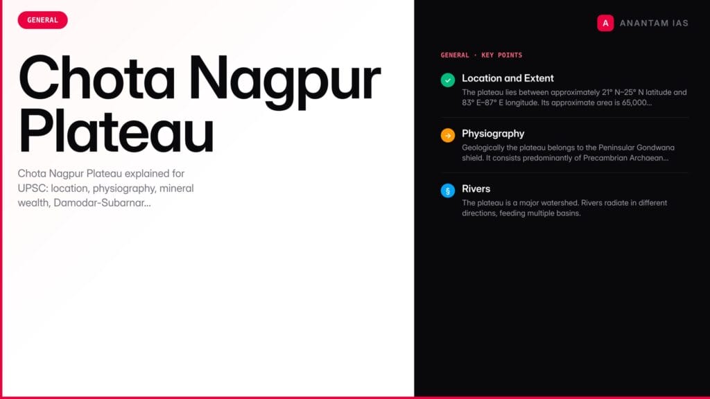
The Chota Nagpur Plateau is a raised, dissected landmass in eastern India that holds one of the largest concentrations of mineral wealth on the Indian subcontinent. It spans parts of Jharkhand, Chhattisgarh, Odisha, West Bengal, and marginally Bihar and Madhya Pradesh. Its coal, iron, mica, bauxite and copper underpin India's steel, power and engineering industries. Geographically it is an ancient Gondwana landmass; demographically it is the heartland of many of India's largest Scheduled Tribes; economically it hosts industrial cities such as Ranchi, Jamshedpur, Bokaro, Dhanbad, Rourkela. For UPSC, Chota Nagpur is a compound topic that weaves together physical geography, economic geography, human geography, and contemporary governance.
Location and Extent
The plateau lies between approximately 21° N–25° N latitude and 83° E–87° E longitude. Its approximate area is 65,000–70,000 sq km, though definitions vary between physiographic (narrower) and economic-geographic (wider) delineations.
| State | Share (approximate) | Principal Districts |
|---|---|---|
| Jharkhand | ~70% | Ranchi, Hazaribagh, Dhanbad, Bokaro, Giridih, Singhbhum (East & West), Palamu |
| Chhattisgarh | ~10% | Surguja, Jashpur, Raigarh fringes |
| Odisha | ~10% | Sundergarh, Mayurbhanj, Keonjhar fringes |
| West Bengal | ~7% | Purulia, Bankura (west), Medinipur fringes |
| Bihar | ~3% | South Bihar fringes adjoining Jharkhand |
It is bounded by:
- North: Indo-Gangetic Plain
- East: Rajmahal Hills and Gangetic West Bengal
- South: Mahanadi basin / Eastern Ghats
- West: Baghelkhand and Maikal range
Physiography
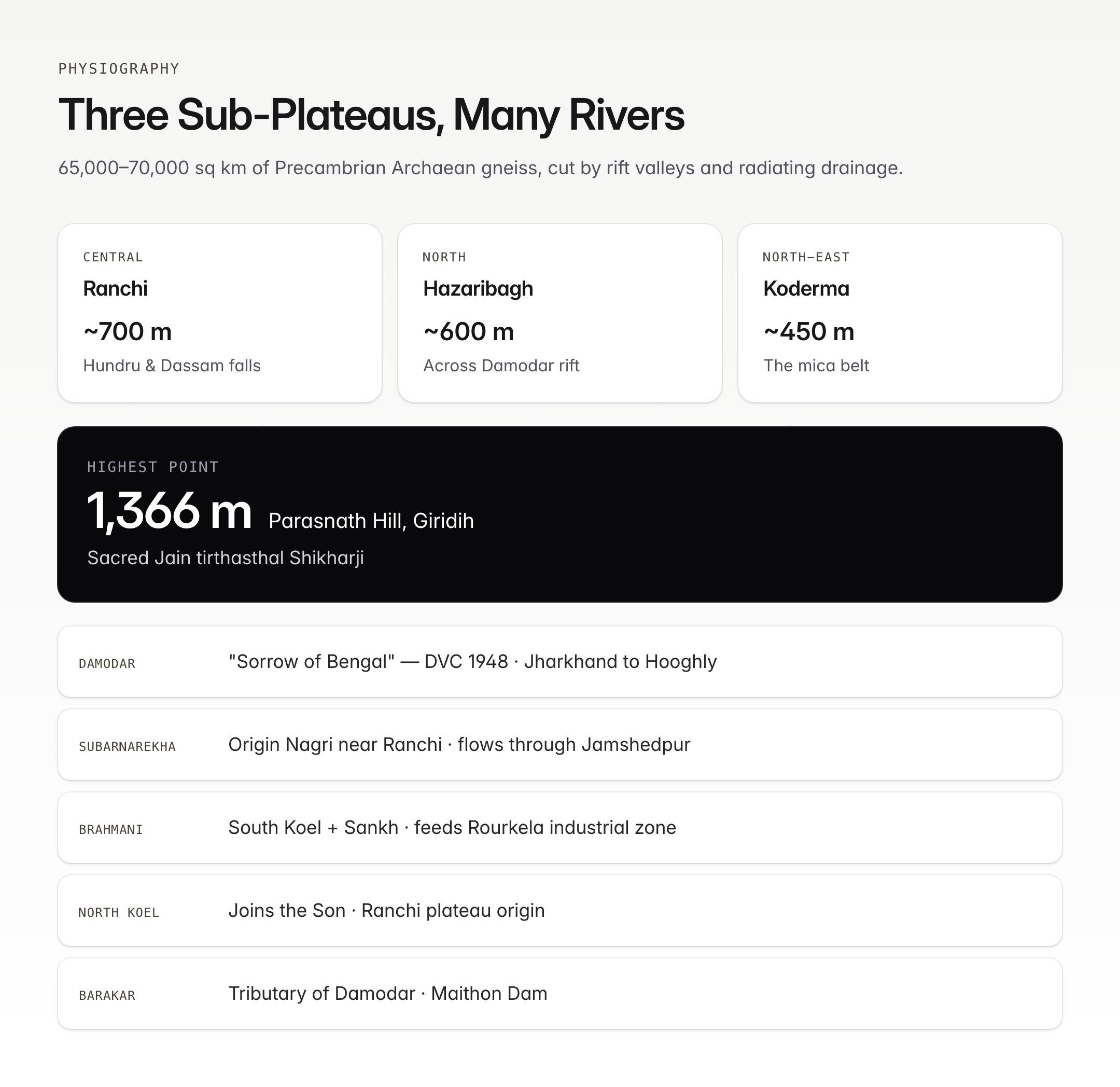
Geologically the plateau belongs to the Peninsular Gondwana shield. It consists predominantly of Precambrian Archaean gneisses and schists (Chota Nagpur Gneissic Complex), intruded by Gondwana sedimentary rocks in the rift basins (Damodar valley) and capped in places by Deccan-like basalt.
It is divided into three sub-plateaus:
| Sub-plateau | Key Features | Average Elevation |
|---|---|---|
| Ranchi Plateau | Central; Ranchi city, Hundru Falls, Dassam Falls on Subarnarekha | ~700 m |
| Hazaribagh Plateau | North; separated from Ranchi by Damodar rift valley | ~600 m |
| Koderma Plateau | North-east; mica belt | ~450 m |
Other notable relief:
- Parasnath Hill (1,366 m) in Giridih — highest point of the plateau; sacred Jain tirthasthal (Shikharji).
- Rajmahal Hills — north-eastern extension into Jharkhand (Sahibganj, Godda), rich in lava flows and Gondwana fossils.
- Dalma Range — near Jamshedpur, with Dalma Wildlife Sanctuary.
- Netarhat Plateau — "Queen of Chota Nagpur," part of the western plateau surface.
- Waterfalls: Hundru, Dassam, Jonha, Hirni, Lodh (highest in Jharkhand, on Budha Ghagh) — products of rejuvenation.
Rivers
The plateau is a major watershed. Rivers radiate in different directions, feeding multiple basins.
| River | Origin | Course | Notes |
|---|---|---|---|
| Damodar | Chandwa plateau, Palamu | East through Jharkhand and West Bengal, joins Hooghly | "Sorrow of Bengal"; DVC (Damodar Valley Corporation) — India's first multipurpose project, 1948 |
| Subarnarekha | Nagri near Ranchi | East through Jharkhand, Odisha, West Bengal to Bay of Bengal | Forms Hundru and Dassam falls; flows through Jamshedpur |
| Koel (North and South) | Ranchi plateau | North Koel joins Son; South Koel joins Brahmani | |
| Brahmani | Confluence of South Koel and Sankh | Odisha, to Bay of Bengal | Important for Rourkela industrial zone |
| Barakar | Hazaribagh | Tributary of Damodar | Maithon Dam |
| Sankh | Sanchi, Jharkhand | Joins South Koel to form Brahmani | |
| Ajay | Munger Hills | West Bengal to Bhagirathi | Eastern part of plateau |
| Mayurakshi | Trikut Hills | Jharkhand to West Bengal | Massanjore Dam |
Mineral Wealth — "Ruhr of India"
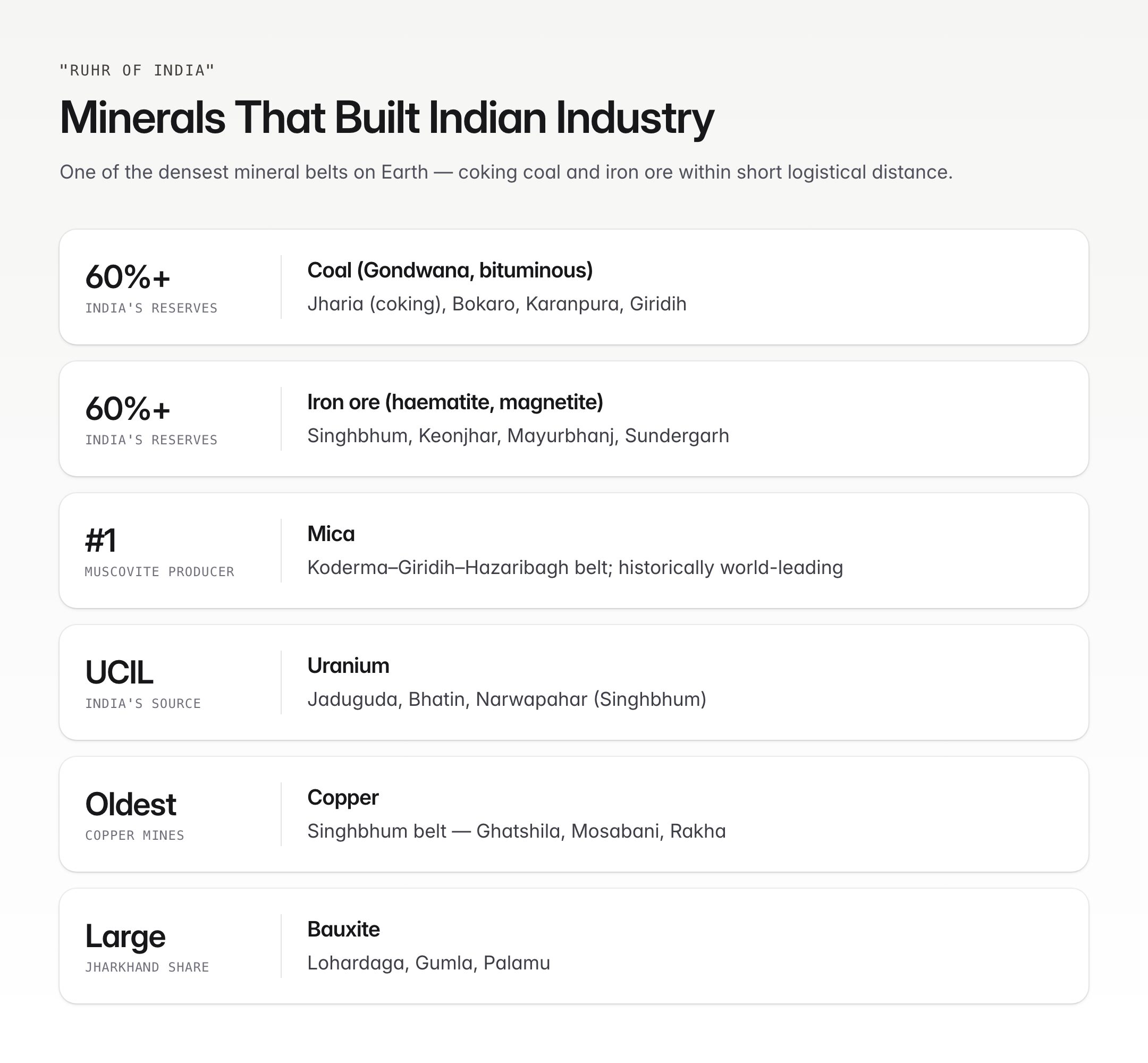
Chota Nagpur Plateau is often called the "Ruhr of India", a reference to Germany's Ruhr industrial region. It is the single most important mineral belt of India.
| Mineral | Major Locations | India's Share |
|---|---|---|
| Coal (Gondwana, bituminous) | Jharia (coking), Bokaro, Raniganj (fringe), Karanpura, Giridih | Chota Nagpur + adjoining holds ~60%+ of India's coal reserves |
| Iron ore (haematite, magnetite) | Singhbhum (Noamundi, Gua), Keonjhar, Mayurbhanj, Sundergarh (Barsua, Kiriburu, Meghahatuburu) | Odisha + Jharkhand hold over 60% of India's reserves |
| Mica (muscovite) | Koderma–Giridih–Hazaribagh belt | Largest muscovite producer; historically world-leading |
| Bauxite | Lohardaga, Gumla, Palamu (Jharkhand); Raigarh | Significant Jharkhand share |
| Copper | Singhbhum copper belt (Ghatshila, Mosabani, Rakha) | Historic — India's oldest copper mines |
| Uranium | Jaduguda, Bhatin, Narwapahar (Singhbhum) | India's principal uranium source (UCIL) |
| Manganese | Singhbhum, Keonjhar | |
| Limestone, dolomite, fireclay, chromite, kyanite | Distributed across plateau |
The combination of coking coal (Jharia) and iron ore (Singhbhum) within short logistical distance made the plateau the natural cradle of Indian heavy industry.
Industrial Cities
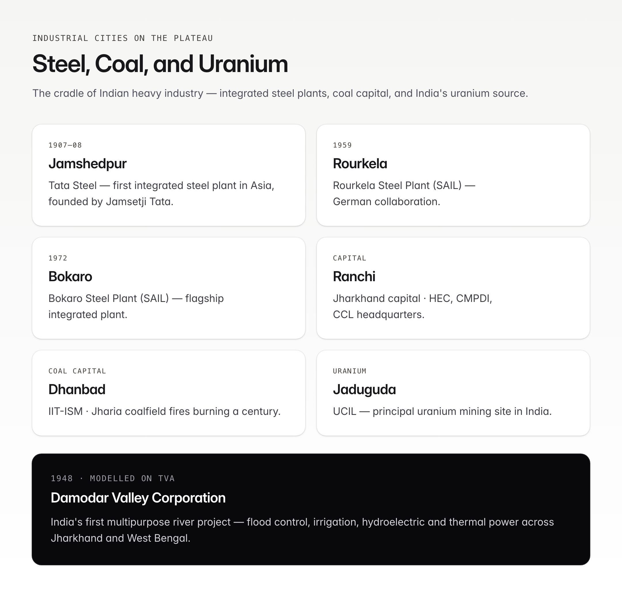
- Jamshedpur — Tata Steel (1907–08, first integrated steel plant in Asia), founded by Jamsetji Tata.
- Bokaro — Bokaro Steel Plant (SAIL), commissioned 1972.
- Rourkela — Rourkela Steel Plant (SAIL), commissioned 1959 (German collaboration).
- Durgapur — Durgapur Steel Plant (SAIL) — just east of the plateau, 1959 (UK collaboration).
- Dhanbad — coal capital, ISM (IIT-ISM) Dhanbad.
- Ranchi — capital of Jharkhand, Heavy Engineering Corporation (HEC), CMPDI, CCL headquarters.
- Bokaro Thermal, Chandrapura, Patratu — thermal power plants along the Damodar.
- Jaduguda — uranium mining, UCIL.
The Damodar Valley Corporation (DVC), modelled on the Tennessee Valley Authority, integrates flood control, irrigation, hydroelectricity and thermal power across Jharkhand and West Bengal.
Climate and Vegetation
Climate is tropical wet-and-dry (Aw/Cwa) with:
- Summer highs of 38–42°C in lower plateau, cooler at Netarhat and Parasnath.
- Rainfall of 1,200–1,600 mm, monsoon-dominated.
- Natural vegetation: tropical dry deciduous and moist deciduous forests — sal (Shorea robusta), mahua (Madhuca longifolia), palash, kendu, bamboo. Rich minor forest produce (MFP) economy.
- Protected areas: Betla National Park (Palamu), Hazaribagh Wildlife Sanctuary, Dalma WLS, Simlipal National Park (Odisha, marginally contiguous).
Tribal Population
Chota Nagpur is one of India's densest tribal regions. Major groups:
| Tribe | Distribution | Language Family |
|---|---|---|
| Santhal | Jharkhand, West Bengal, Odisha | Austroasiatic (Mundari branch) — Santali (8th Schedule) |
| Oraon (Kurukh) | Jharkhand, Chhattisgarh | Dravidian |
| Munda | Ranchi, Khunti, Singhbhum | Austroasiatic |
| Ho | Singhbhum | Austroasiatic |
| Bhumij | Jharkhand, West Bengal, Odisha | Austroasiatic/Indo-Aryan |
| Kharia | Simdega, Gumla | Austroasiatic |
| Asur, Birhor, Paharia (Sauria and Mal), Korwa | PVTGs in Chota Nagpur belt | Various |
The plateau witnessed foundational tribal movements: Kol Revolt (1831–32), Santhal Hul (1855–56) led by Sidhu-Kanhu-Chand-Bhairav, Birsa Munda‘s Ulgulan (1895–1900). The Chota Nagpur Tenancy Act, 1908 and Santhal Parganas Tenancy Act, 1949 bar transfer of tribal land to non-tribals — among India’s most significant tribal land protection laws. The plateau is also where PESA and the Forest Rights Act are centrally operational.
Challenges
- Mining-induced displacement and rehabilitation deficits.
- Coal mine fires — Jharia coalfield underground fires burning for over a century.
- Environmental degradation — air quality in Dhanbad/Jharia, water contamination near Jaduguda.
- Left-Wing Extremism — Red Corridor overlaps with tribal belt; though significantly rolled back after 2017, residual affected districts remain.
- Human–elephant conflict — migratory corridors crossing Jharkhand-Odisha-West Bengal.
- Land alienation despite CNT and SPT Acts; pressure to amend tenancy laws resisted by tribal movements.
- Infrastructure gaps — health, education, connectivity in interior blocks.
UPSC Relevance
Prelims: States covered, sub-plateau names (Ranchi, Hazaribagh, Koderma), highest point Parasnath Hill (1,366 m), major rivers (Damodar, Subarnarekha, Koel, Brahmani), DVC (1948), CNT Act (1908), key mineral locations (Jharia–coal, Singhbhum–iron/copper/uranium, Koderma–mica, Lohardaga–bauxite), tribes and PVTGs.
GS-I (Geography): Plateau formation, Gondwana geology, mineral distribution, drainage, "Ruhr of India." Typical question: "Discuss the geological and economic significance of the Chota Nagpur Plateau in India's industrial landscape."
GS-I (Society): Tribal communities, tribal movements, cultural geography.
GS-III (Economy / Internal Security): Mineral resources, LWE, displacement, environmental concerns.
Essay: Themes like "resource curse and resource wealth," "development and displacement," "tribal heritage and modernisation."
Interview: Expect questions on Jharia coal fires, uranium mining at Jaduguda, CNT Act debates, Jharkhand's development trajectory post-2000 bifurcation.
Know the plateau three ways: rocks (mineral belt that industrialised India), rivers (Damodar-Subarnarekha and DVC), and people (Santhal, Munda, Oraon whose land laws still hold). That is the full UPSC package for Chota Nagpur.
Tell Google you want more of this.
Add Anantam IAS as a preferred sourceOne tap, and this site shows up more often in your own Top Stories, AI Overviews and AI Mode. Remove it any time.






