Why in News?
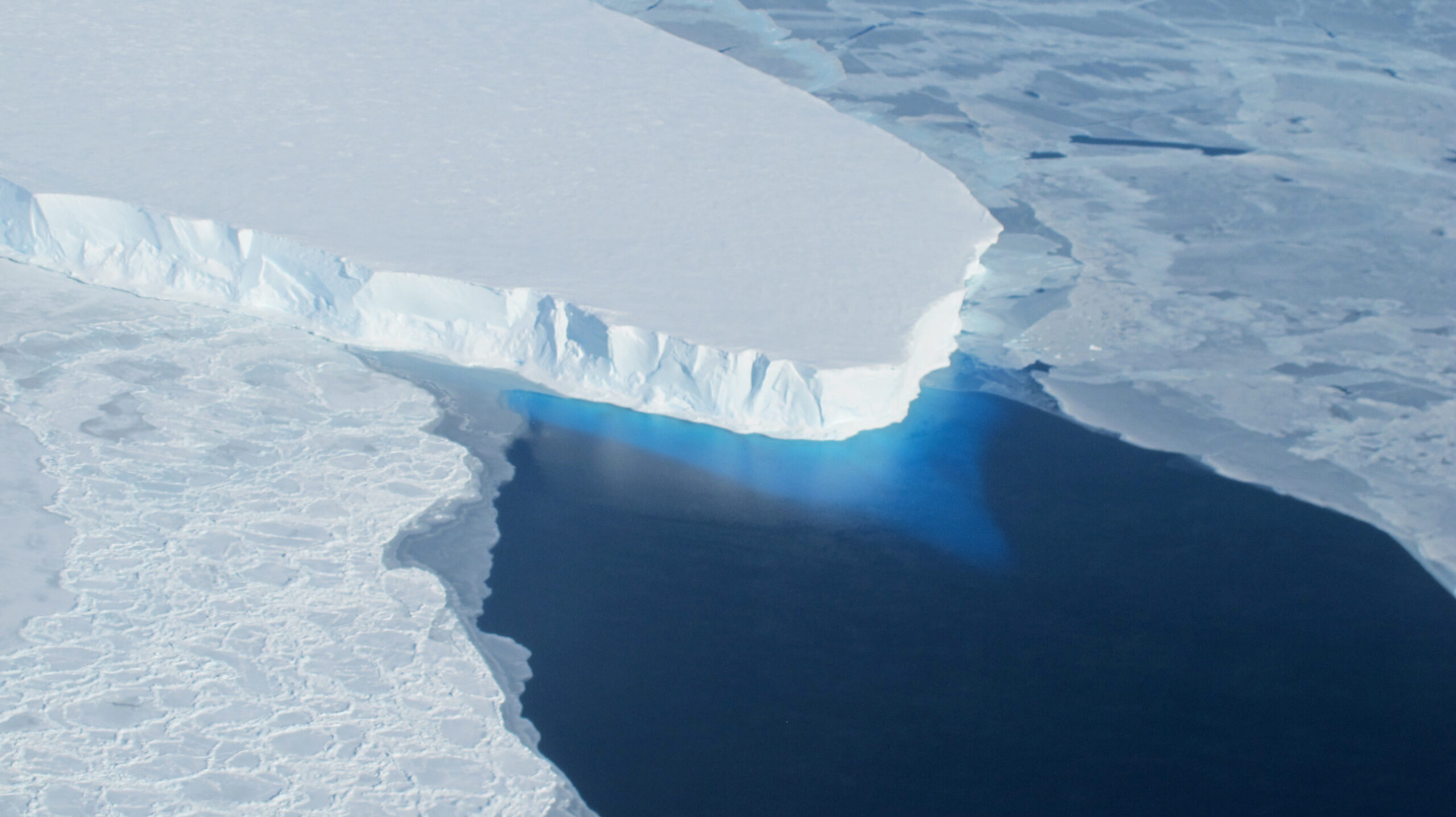
Thwaites Glacier in West Antarctica — popularly called the Doomsday Glacier — remains the most closely watched ice mass on Earth, with researchers warning that its grounding line is retreating faster than models predicted as warm ocean water melts it from below.
Roughly the size of Florida (about 192,000 sq km), Thwaites alone holds enough ice to lift global mean sea level by around 65 cm, and its loss could unpin the wider West Antarctic Ice Sheet (WAIS), with far larger long-term consequences for coastal nations including India.
- Nickname: dubbed the Doomsday Glacier for its outsized, potentially abrupt impact on global sea level.
- Scale: roughly Florida-sized (~192,000 sq km), one of the widest glaciers on the planet.
- Direct contribution: full collapse could raise global sea level by about 65 cm.
- Tipping risk: acts as a cork holding back the West Antarctic Ice Sheet, which stores enough ice for several metres of rise.
- Mechanism: warm Circumpolar Deep Water is melting the glacier at its grounding line, accelerating retreat.
- India link: rising seas threaten low-lying coasts, deltas and island groups, sharpening the case for polar research from stations Maitri and Bharati.
The development matters in the context of:
- Cryosphere stress: Antarctica and Greenland are now the dominant drivers of accelerating sea-level rise, overtaking thermal expansion.
- Marine ice-sheet instability: glaciers grounded below sea level on inward-sloping beds, like Thwaites, can retreat in a self-sustaining feedback once destabilised.
- IPCC framing: the IPCC flags polar ice loss as a low-probability, high-impact tail risk that could push sea levels beyond central projections.
- Coastal India: Mumbai, Kolkata, Chennai, the Sundarbans and Lakshadweep are highly exposed to even decimetre-scale sea-level change.
UPSC Relevance
Prelims Relevance
- Thwaites Glacier location — West Antarctica, draining into the Amundsen Sea embayment.
- Meaning of an ice shelf versus a grounding line versus sea ice.
- West Antarctic Ice Sheet (WAIS) as a marine-based ice sheet grounded below sea level.
- Circumpolar Deep Water (CDW) — a relatively warm, salty water mass circling Antarctica.
- Concept of thermohaline circulation and the role of polar waters in it.
- Components of the cryosphere: glaciers, ice sheets, ice shelves, sea ice, permafrost.
- India’s Antarctic research stations — Maitri, Bharati (and historic Dakshin Gangotri).
- Nodal Indian body for polar science — NCPOR, under the Ministry of Earth Sciences.
- The IPCC as the UN body assessing climate science and sea-level projections.
- Difference between thermal expansion and land-ice melt contributions to sea-level rise.
Mains Relevance
GS Paper 1 (Geography)
- Explain how grounding-line retreat and warm ocean intrusion destabilise marine-based ice sheets, and why this matters for global geomorphology.
- Discuss the cryosphere’s role in regulating sea level and ocean circulation, using Thwaites as a case study.
GS Paper 3 (Environment)
- Assess the implications of polar ice-sheet instability for India’s coastal vulnerability and disaster preparedness.
- Evaluate the significance of international and Indian polar research in monitoring climate tipping points.
Essay
- Use Thwaites as a vivid anchor in essays on climate tipping points, intergenerational equity and the limits of prediction.
- Relevant to essays on the commons, planetary boundaries and the ethics of acting under deep uncertainty.
Background and Context
Where Thwaites sits and why it is called the Doomsday Glacier
A vast, fast-flowing outlet glacier with disproportionate leverage over global sea level.
- Setting: lies in West Antarctica, draining into the Amundsen Sea.
- Size: about Florida-sized (~192,000 sq km) and exceptionally wide at its ocean front.
- Nickname: called the Doomsday Glacier because its collapse could trigger large, hard-to-reverse sea-level rise.
- Cork effect: it buttresses neighbouring ice; losing Thwaites could unplug a much larger reservoir of inland ice.
Cryosphere basics: ice shelves, grounding lines and sea ice
Getting the vocabulary right is half the battle in answering questions on polar ice.
- Cryosphere: the frozen parts of the Earth system — glaciers, ice sheets, ice shelves, sea ice and permafrost.
- Ice shelf: the floating extension of a glacier or ice sheet over the ocean; it already displaces water, so its melt adds little directly to sea level.
- Grounding line: the boundary where the ice lifts off the bedrock and begins to float; its inland retreat signals real ice loss.
- Sea ice: frozen seawater that forms and melts seasonally — distinct from land-based glacial ice.
How warm water is undermining the glacier
The threat to Thwaites comes mainly from the ocean below, not the air above.
- Circumpolar Deep Water: relatively warm, salty water is being drawn beneath the floating ice, melting it from underneath.
- Grounding-line retreat: as the line shifts inland over a downward-sloping bed, thicker ice meets the ocean and melts faster — a self-reinforcing loop.
- Marine ice-sheet instability: glaciers grounded below sea level on reverse-sloping beds can retreat in a runaway fashion once tipped.
- Thinning shelf: weakening of the floating ice shelf reduces the back-pressure that slows the glacier’s flow to the sea.
Sea-level rise and the link to thermohaline circulation
Polar ice does not only raise seas; it also helps power the global ocean conveyor.
- Direct rise: a full Thwaites collapse adds roughly 65 cm to global mean sea level; destabilising the wider WAIS could add several metres over centuries.
- Two drivers: sea-level rise comes from thermal expansion of warming water plus land-ice melt from glaciers and ice sheets.
- Thermohaline circulation: cold, dense polar water sinks and drives the deep-ocean conveyor belt; large freshwater pulses from melting ice can disrupt it.
- IPCC view: the IPCC treats rapid polar ice loss as a high-impact risk that could push rise above central projections.
India's stake and its polar research footprint
A glacier on the far side of the planet has direct consequences for Indian coasts.
- Exposed coasts: Mumbai, Kolkata, Chennai, the Sundarbans delta and Lakshadweep are highly vulnerable to even small rises.
- India in Antarctica: research is run from the stations Maitri and Bharati, coordinated by NCPOR under the Ministry of Earth Sciences.
- Monitoring: Indian glaciology and ocean science feed into global assessments of ice loss and sea-level projections.
- Adaptation: coastal zone management, mangrove protection and disaster preparedness become central planning priorities.
Why prediction is hard and the stakes of uncertainty
The honest answer is that scientists cannot yet date the collapse precisely.
- Deep uncertainty: the timing of any rapid collapse spans decades to centuries, but the direction of travel is clear.
- Inaccessibility: the glacier’s remote, harsh setting makes direct measurement difficult and costly.
- Irreversibility: once marine ice-sheet instability is triggered, retreat may continue even if warming stabilises.
- Precaution: high-impact tail risks justify aggressive emission cuts and serious investment in polar observation.
Way Forward
Strengthen polar observation
- Sustained monitoring: expand under-ice ocean sensors, satellite altimetry and grounding-line surveys to narrow timing estimates.
- Indian capacity: deepen NCPOR-led glaciology and Southern Ocean research from Maitri and Bharati.
Cut emissions and plan for the long tail
- Mitigation: rapid decarbonisation remains the only lever that meaningfully lowers worst-case sea-level outcomes.
- Scenario planning: incorporate high-end ice-loss scenarios into long-term coastal and infrastructure decisions.
Build coastal resilience in India
- Coastal management: enforce coastal regulation zones, protect mangroves and restore natural buffers.
- Preparedness: map flood-exposed assets and embed sea-level rise into city master plans and disaster frameworks.
Conclusion
The leverage point: Thwaites earns its grim nickname because a single, remote glacier can swing global sea level by tens of centimetres and unlock far more by destabilising the West Antarctic Ice Sheet.
The mechanism is clear: warm Circumpolar Deep Water eroding the grounding line is a textbook case of how the ocean, not just the air, drives modern ice loss.
The Indian lesson: a frozen continent’s fate is tied to the safety of Indian deltas and cities, which is exactly why polar research and decisive climate action are national, not distant, concerns.
UPSC Practice Questions
Prelims MCQ 1
With reference to Thwaites Glacier, consider the following statements:
- It is located in West Antarctica and drains into the Amundsen Sea.
- Its destabilisation is driven mainly by warm Circumpolar Deep Water melting it at the grounding line.
- It is roughly the size of the state of Florida.
How many of the above statements are correct?
(a) Only one (b) Only two (c) All three (d) None
Answer: (c) All three
Explanation:
Thwaites lies in West Antarctica draining into the Amundsen Sea, is roughly Florida-sized, and is being undermined by warm Circumpolar Deep Water at its retreating grounding line. All three statements are correct.
Prelims MCQ 2
Which one of the following best explains why melting of a floating ice shelf adds little directly to global sea level?
(a) Ice shelves are made of frozen seawater, which is denser than ice (b) The floating ice already displaces ocean water before it melts (c) Ice shelves are located above the grounding line on bedrock (d) Meltwater from ice shelves evaporates before reaching the ocean
Answer: (b) The floating ice already displaces ocean water before it melts
Explanation:
A floating ice shelf already displaces its own weight of water (Archimedes’ principle), so its melt adds little directly. Loss of land-based grounded ice, and the loss of buttressing that speeds up glaciers, is what raises sea level.
UPSC Mains Questions
- Explain the mechanism of marine ice-sheet instability with reference to Thwaites Glacier. Why is the retreat of the grounding line considered a more reliable indicator of ice loss than the melting of floating ice shelves?
- Polar ice-sheet instability is a low-probability, high-impact climate risk. Discuss its implications for India’s coastal regions and the role of Indian polar research in addressing this challenge.
- Distinguish between thermal expansion and land-ice melt as drivers of sea-level rise. How might large freshwater inputs from Antarctic melting affect global thermohaline circulation?
Sources: National Centre for Polar and Ocean Research (NCPOR), Ministry of Earth Sciences and Intergovernmental Panel on Climate Change (IPCC).
Frequently Asked Questions
Why is Thwaites called the Doomsday Glacier?
Because its collapse could raise global sea level by around 65 cm on its own and, by unplugging the wider West Antarctic Ice Sheet, eventually contribute several metres more. A single glacier with that much leverage over the world’s coastlines earns the dramatic nickname.
Where is Thwaites Glacier located?
It lies in West Antarctica, draining into the Amundsen Sea. Roughly the size of Florida (about 192,000 sq km), it is one of the widest glaciers on Earth and a key part of the marine-based West Antarctic Ice Sheet.
What is making the glacier retreat?
Mainly the ocean, not the air. Relatively warm, salty Circumpolar Deep Water is drawn beneath the floating ice and melts it from below. As the grounding line retreats inland over a downward-sloping bed, melting accelerates in a self-reinforcing loop.
What is the difference between an ice shelf and a grounding line?
An ice shelf is the floating extension of a glacier over the sea; because it already displaces water, its melt adds little directly to sea level. The grounding line is where ice lifts off bedrock and starts to float — its inland retreat marks genuine loss of land-based ice.
How does Thwaites threaten coastal India?
Sea-level rise from Antarctic ice loss endangers low-lying Indian coasts and deltas — Mumbai, Kolkata, Chennai, the Sundarbans and Lakshadweep. Even decimetre-scale rise worsens flooding, erosion and saltwater intrusion, making coastal management and disaster preparedness urgent.
What is India’s role in polar research?
India runs Antarctic science from its stations Maitri and Bharati, coordinated by the NCPOR under the Ministry of Earth Sciences. This work on glaciers and the Southern Ocean feeds into global assessments of ice loss and sea-level rise.
Tell Google you want more of this.
Add Anantam IAS as a preferred sourceOne tap, and this site shows up more often in your own Top Stories, AI Overviews and AI Mode. Remove it any time.