

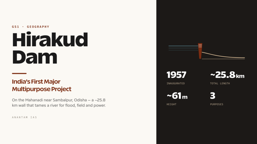
Hirakud Dam is the kind of structure that makes more sense the longer you look at it. Drive along its crest and you don’t reach the far bank in a minute or two, the way you would on most dams. You keep going. Counting the earthen dykes that close the gaps between the surrounding hills, the whole barrier runs to roughly 25.8 kilometres across the Mahanadi near Sambalpur in Odisha, which is why it is so often called one of the longest dams on earth. Behind it sits an artificial lake big enough to be seen clearly from space.
But the scale isn’t really the point. Hirakud matters because of when it was built and what it was for. Inaugurated in 1957, it was independent India’s first major multipurpose river-valley project, the prototype for a model of development that Jawaharlal Nehru famously called the “temples of modern India.” It was meant to tame a river that drowned the Mahanadi delta almost every monsoon, to water fields that had only ever known the rain, and to light up a region with no power. Seventy years on, it has done all three and accumulated a second story underneath the first: of silt slowly filling the reservoir, of farmers and factories fighting over the same water, and of a long-running quarrel with the state next door over who controls the river upstream.
What and Where: The Dam on the Mahanadi
The Mahanadi is one of peninsular India’s great rivers. It rises in the Sihawa hills of Dhamtari district in Chhattisgarh, flows east and north-east across Chhattisgarh and Odisha, and finally fans out into a broad delta around Cuttack before spilling into the Bay of Bengal. It drains a basin of about 1.4 lakh square kilometres shared mainly between the two states. And for most of recorded history its lower reaches were a disaster zone. The delta floods of 1937 and 1943 were the immediate provocation, but flooding here was an annual fact of life, not an occasional shock.
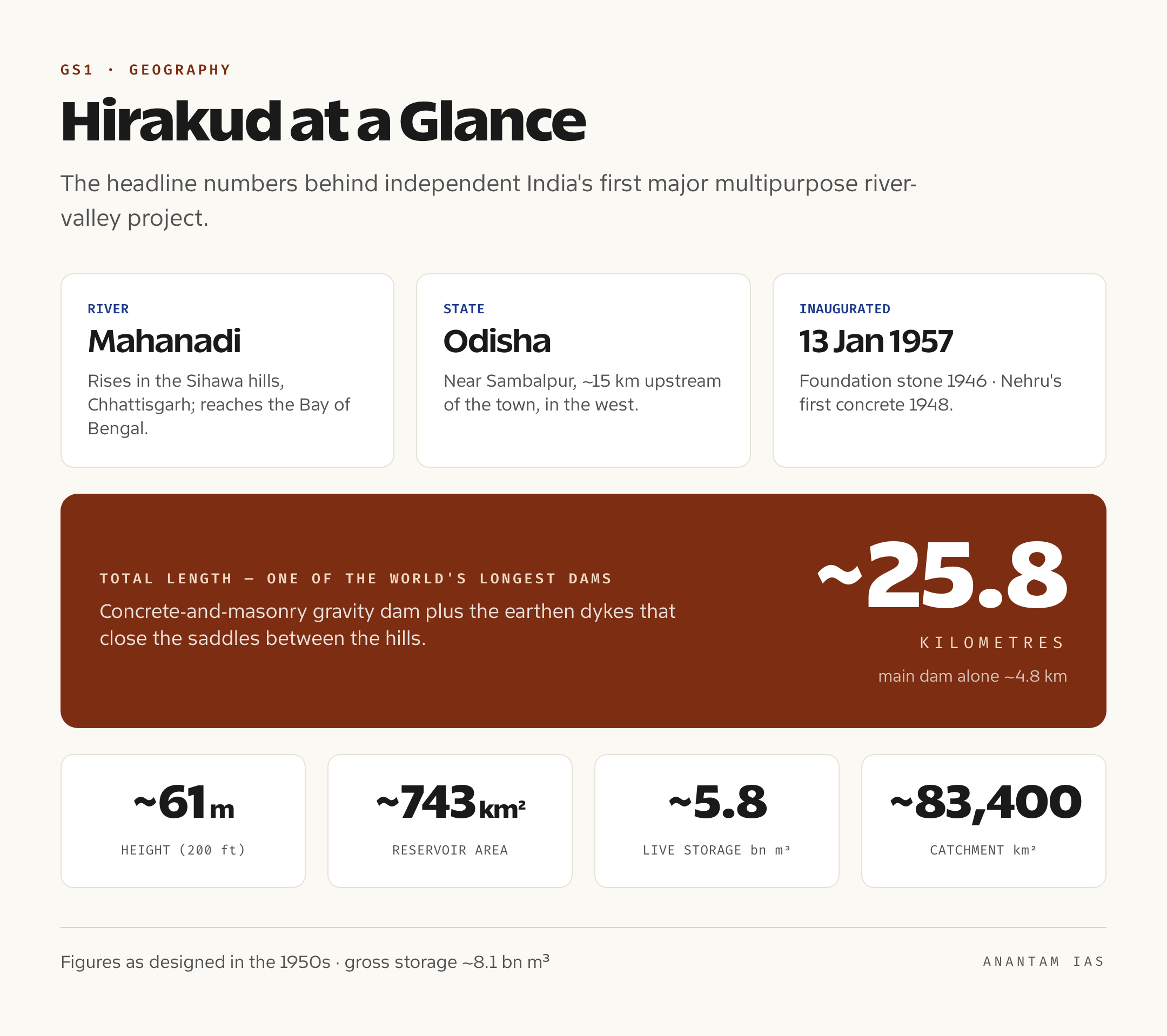
Hirakud sits on this river about 15 kilometres upstream of Sambalpur town, in western Odisha. Its job is to catch the run-off from a catchment of roughly 83,400 square kilometres before that water reaches the vulnerable delta downstream. Geographically that placement is the whole logic of the dam: stand far enough up the river to hold back the flood peak, but stay close enough to the productive delta and the power-hungry industrial belt to serve them.
So when a Prelims question asks “Hirakud Dam is built on which river?” the answer is the Mahanadi, in Odisha, near Sambalpur. The harder Mains point is that you cannot understand Hirakud through Odisha alone. A dam is only as good as the river feeding it, and that river is born in Chhattisgarh. That single fact sits underneath almost every modern problem the project now faces.
Engineering and Reservoir: A Composite Giant
Hirakud isn’t one dam so much as a system. The central section is a concrete and masonry gravity dam, the part that holds the main channel of the Mahanadi. On either flank, where the valley opens into low saddles between hills, long earthen dykes close the gaps. The main dam stretches about 4.8 kilometres; add the dykes on both banks and the total length reaches that headline figure of around 25.8 kilometres. The structure stands about 61 metres (200 feet) high. Water is controlled through a large bank of gates, with separate sluice gates near the riverbed and crest gates along the top to release floodwater in a controlled way.
Behind the wall lies the Hirakud Reservoir, one of the largest artificial lakes in Asia. At full capacity it spreads across roughly 743 square kilometres with a shoreline running over 600 kilometres, and it stretches dozens of kilometres back up the valley. The original design gave it a gross storage of close to 8.1 billion cubic metres, of which the usable, or “live,” storage was about 5.8 billion cubic metres. That live storage is the working heart of the project: the cushion the dam uses to swallow a flood peak in July and the bank balance it draws down to irrigate fields and spin turbines through the dry months.
Two observation towers crown the dam, Gandhi Minar and Nehru Minar, and from them the reservoir reads like an inland sea. It’s worth remembering, though, that these numbers describe the dam as designed in the 1950s. The most important thing about Hirakud today is that one of them, the live storage, is no longer what the engineers wrote down.
Purposes and Significance: Why It Was Built
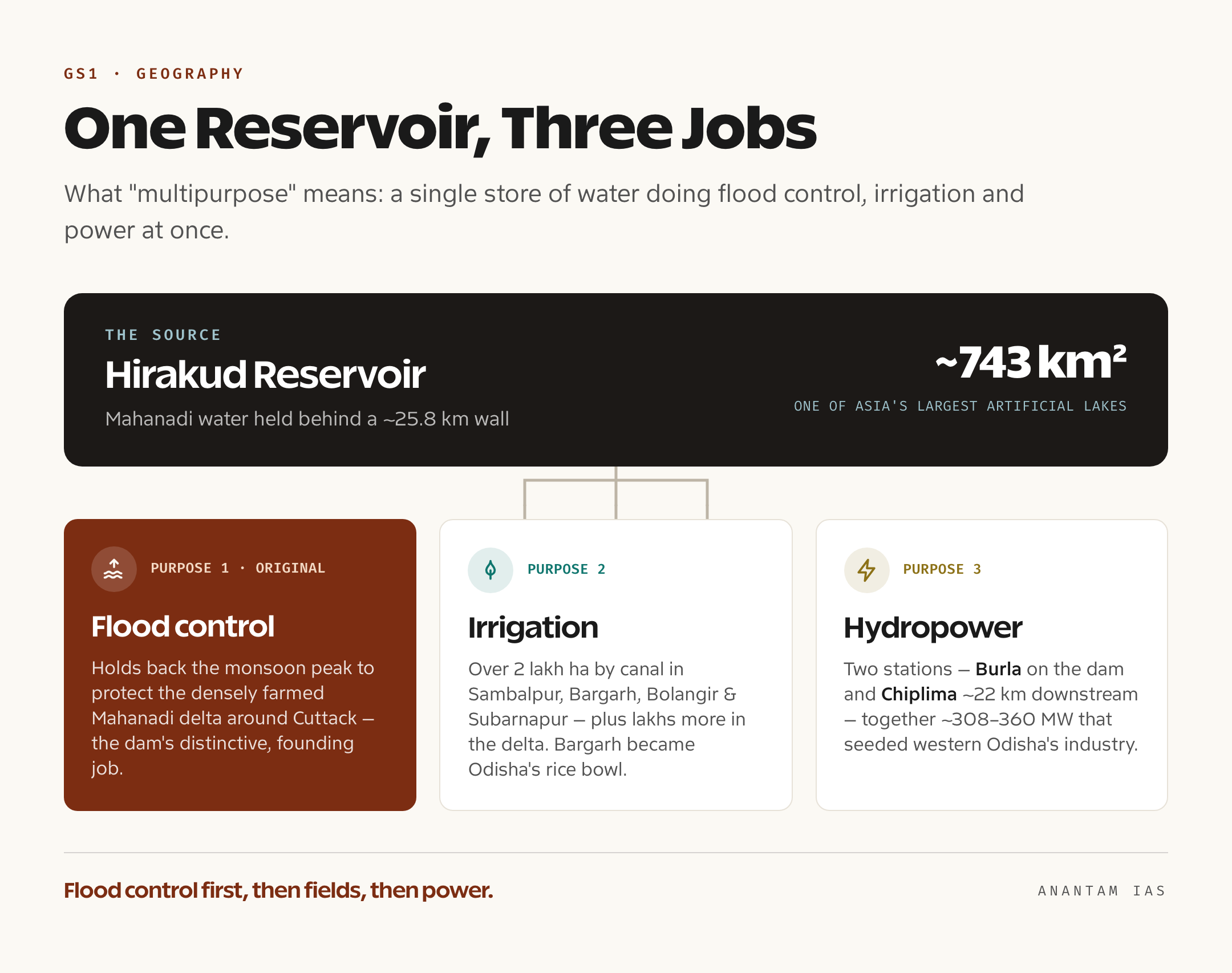
Hirakud was designed to do three jobs at once, which is exactly what “multipurpose” means, and the order in which it was meant to do them tells you a lot about the project.
The first job, and the distinctive one, is flood control. Most famous Indian dams are remembered for irrigation or power. Hirakud was conceived first as a flood-control structure for the Mahanadi delta, the densely populated and intensely farmed stretch around Cuttack that the river had drowned for centuries. By holding back the monsoon peak in its reservoir and then releasing water in a managed way, the dam protects a large swathe of delta. It hasn’t ended flooding entirely, and a few severe years have still seen heavy releases, but it has converted a near-annual catastrophe into an occasional emergency. For a country that prioritised flood control in its First Five Year Plan, that was the headline achievement.
The second job is irrigation. The project waters well over two lakh hectares in the upstream districts of Sambalpur, Bargarh, Bolangir and Subarnapur through its canal network, and the water released through the power houses goes on to irrigate several lakh hectares more in the Mahanadi delta downstream. Bargarh district, fed by the canal system, turned into one of Odisha’s most reliable rice-growing zones, often called the rice bowl of the state. Land that had depended entirely on a fickle monsoon could suddenly grow a second crop.
The third job is hydropower. Hirakud generates electricity at two stations: the Burla power house, built into the right bank of the dam, and the Chiplima power house about 22 kilometres downstream, which uses the natural fall of the river. Their combined installed capacity is in the range of around 308 to 360 megawatts depending on the count of units over the years. That power, modest by today’s standards, was transformative in the 1950s and 1960s. It helped seed the industrial belt running through Sambalpur, Jharsuguda and Rourkela, including the energy-hungry aluminium and steel plants that still define western Odisha’s economy.
The timing is part of the significance. The foundation stone went down in 1946, Nehru laid the first batch of concrete in 1948, and he returned to inaugurate the completed dam on 13 January 1957, by which point it had become the showpiece of the First Five Year Plan. This was the era when Nehru spoke of large dams and steel plants as the “temples of modern India,” and Hirakud was the first of them on this scale. So the significance is not just hydraulic. It is the founding example of the dam-led development model that India bet on after independence, the template that Bhakra-Nangal, Nagarjuna Sagar and a generation of projects went on to follow.
Problems: Silt, Water Fights and an Old Wound
The trouble with a reservoir is that rivers carry mud as well as water, and the mud doesn’t leave. Decade after decade, silt brought down by the Mahanadi settles on the bed of the Hirakud Reservoir and quietly steals its storage. This is the project’s most serious physical problem. Survey and remote-sensing studies have tracked the loss for years, and recent assessments reported in 2025 suggest the reservoir’s overall capacity has dropped by around a quarter since 1957, with the usable live storage shrinking too. Less storage means a smaller cushion for the flood peak and less water banked for the dry season, which erodes every one of the dam’s three purposes at once. Projections in the technical literature warn that, on current trends, a very large share of the original live storage could be gone within a century of impounding.
The second problem is a fight over the water that does arrive: farms versus factories. As industry expanded across the Sambalpur-Jharsuguda belt, more and more of Hirakud’s water was allocated to thermal power plants and other plants. Farmers in the command area, especially in years of weak monsoon, have protested bitterly that water meant for their fields is being diverted to industry. Those tensions have spilled into the streets more than once, and they go to the core of the multipurpose model: when there isn’t enough water for everyone, who gets first call.
The third problem is the oldest and the rawest: people. Building the reservoir meant flooding the valley behind the dam. By official accounts the project submerged hundreds of villages and displaced around 22,000 families, roughly a lakh or more people, many of them tribal and small farmers. Rehabilitation was widely criticised as inadequate; decades later, displaced families and groups like the Hirakud Budi Anchal Sangram Samiti were still demanding the land and compensation they were promised. Hirakud became, and remains, a textbook case in India’s long argument about development versus displacement.
And then there is the river itself. Because the Mahanadi rises in Chhattisgarh, dams and barrages built upstream affect how much water reaches Hirakud, especially in the lean season. Odisha has long argued that upstream construction in Chhattisgarh is choking its share of the flow. In 2018 the Centre constituted the Mahanadi Water Disputes Tribunal to settle the matter. Progress has been slow and litigious; after a change of chairperson, the tribunal is now headed by a Supreme Court judge, and in recent hearings it has pressed both states toward a negotiated settlement, with reports in 2025 indicating a firm deadline before it delivers a binding verdict. The dispute is the modern face of that early lesson: Hirakud’s fortunes are decided as much upstream, in another state, as at the dam wall itself.
The Way Forward: Keeping a Seventy-Year-Old Dam Useful
Hirakud’s problems are real, but none of them argue for abandoning it. They argue for modernising it, and several threads of that effort are already underway.
The first priority is the storage itself, which means taking siltation seriously instead of treating it as background noise. That includes catchment-area treatment in the upstream basin, planting and soil conservation to cut the sediment load before it reaches the reservoir, and honest, regular bathymetric surveys so that operating rules are based on the reservoir’s real capacity today, not its 1957 design figures. Dam safety is the second priority, and here Hirakud has been folded into the Centre’s Dam Rehabilitation and Improvement Project, backed by the World Bank, under which an additional spillway and structural upgrades are planned to let the ageing dam pass extreme floods safely.
The third fix is governance of the water. The farms-versus-industry clash needs transparent, published allocation rules and genuine community participation, not ad hoc diversions decided in a drought. And the interstate question needs the Mahanadi tribunal to land a durable, basin-wide sharing formula, because piecemeal upstream construction without a settlement guarantees recurring conflict. Finally, the rehabilitation wound should be closed rather than ignored: settling the long-pending claims of Hirakud’s oustees is both a matter of justice and a precondition for public trust in any future water project.
The larger lesson is that a multipurpose dam is not a monument you build once and admire. It is a living piece of infrastructure that has to be re-surveyed, repaired and re-governed for every generation it serves. Hirakud’s first seventy years proved the model could work. Its next phase will test whether India can maintain what it built.
For Your Mains Answer
Hirakud is a flexible example that maps onto several papers. In GS Paper 1 (Geography) it sits under drainage systems, peninsular rivers and multipurpose river-valley projects. In GS Paper 3 it serves disaster management (flood control), agriculture and irrigation, infrastructure, and the environmental and water-resource debates around large dams. The development-versus-displacement angle is also usable in GS Paper 2 (governance, rehabilitation policy) and even the Essay paper.
How to Build the Answer
Start with the river, not the dam. Locate the Mahanadi, name the flood-prone delta, and only then introduce Hirakud as independent India’s first major multipurpose project. Lay out its three purposes in order, lead with flood control because that is what makes it distinctive, then move to the problems and a way forward. The arc location and purpose, then problems, then solutions works for almost any dam or river-project question.
Common Mistakes to Avoid
Don’t say Nehru laid the foundation stone in 1948; the foundation stone was actually laid in 1946, Nehru laid the first concrete in 1948, and he inaugurated the completed dam in 1957. Don’t quote the original storage capacity as if it still holds, the siltation loss is the whole point. Don’t reduce Hirakud to its length; “longest dam” is a Prelims hook, not a Mains argument. And don’t forget the upstream dimension; an answer that treats this as a purely Odisha story misses the Mahanadi dispute entirely.
A Compact Answer Spine
Mahanadi rises in Chhattisgarh, drowns the Odisha delta → Hirakud built near Sambalpur as India’s first major multipurpose project (inaugurated 1957) → composite dam ~25.8 km, huge reservoir → three purposes: flood control, irrigation, hydropower (Burla, Chiplima) → problems: siltation cutting storage, farms versus industry, displacement legacy, Mahanadi interstate dispute → way forward: catchment treatment, dam safety (DRIP), transparent allocation, tribunal settlement, closing rehabilitation claims.
Diagram or Flowchart Idea
Draw the Mahanadi as a single arrow from Chhattisgarh (source) to the Bay of Bengal (delta), mark Hirakud on it near Sambalpur, and branch three labelled outputs from the reservoir: “flood control” down to the delta, “irrigation” to the canal districts, and “power” to Burla and Chiplima. Add an upstream node labelled “Chhattisgarh dams and barrages” to show why the interstate dispute exists. It captures geography and function in one frame.
A Balanced-Conclusion Line
Hirakud shows both the promise and the price of the dam-led development model: it tamed a killer river and powered a region, but the bill, in silt, in displacement and in interstate friction, is one that every generation has to keep paying.
How to Use Data Without Cramming
You need only a handful of anchors: inaugurated 1957, total length about 25.8 km, height about 61 m, three purposes, reservoir capacity down by roughly a quarter since 1957 due to silt, and tribunal constituted in 2018. Drop the unmemorable decimals. Examiners reward a candidate who knows that the storage is shrinking far more than one who recites the exact original cubic-metre figure.
FAQ
On which river is Hirakud Dam built, and where is it? Hirakud Dam is built across the Mahanadi River near Sambalpur in western Odisha, about 15 kilometres upstream of the town. The Mahanadi rises in the Sihawa hills of Chhattisgarh, flows east through Chhattisgarh and Odisha, and reaches the Bay of Bengal through a delta around Cuttack.
Why is Hirakud called one of the longest dams in the world? Its total length, counting the main concrete-and-masonry dam plus the long earthen dykes that close the saddles between the surrounding hills, comes to roughly 25.8 kilometres. The main dam alone is about 4.8 kilometres. That combined span made it one of the longest dam structures on earth when it was completed in 1957.
What are the main purposes of Hirakud Dam? It is a multipurpose project with three jobs: flood control in the Mahanadi delta (its original and most distinctive purpose), irrigation for districts such as Sambalpur, Bargarh and Bolangir, and hydropower from the Burla and Chiplima power houses. It was independent India’s first major multipurpose river-valley project.
What is the Mahanadi water dispute, and how does it affect Hirakud? Because the Mahanadi rises in Chhattisgarh, dams and barrages built upstream there affect how much water reaches Hirakud, especially in the dry season. Odisha argues this curtails its share. The Centre set up the Mahanadi Water Disputes Tribunal in 2018 to resolve the issue, and it has been pushing both states toward a binding water-sharing settlement.
Practice Questions
Prelims MCQs
- Hirakud Dam is built across which river? Options:
(a) Godavari
(b) Mahanadi
(c) Krishna
(d) Brahmani.
Answer: (b) The Mahanadi, which rises in Chhattisgarh and flows through Odisha to the Bay of Bengal. - In which state and near which town is Hirakud Dam located? Options:
(a) Chhattisgarh, near Raipur
(b) Andhra Pradesh, near Vijayawada
(c) Odisha, near Sambalpur
(d) Jharkhand, near Ranchi.
Answer: (c) It lies near Sambalpur in western Odisha, upstream of the Mahanadi delta. - Which of the following is correct about Hirakud Dam? Options:
(a) It was a British-era project completed before 1947
(b) It was independent India’s first major multipurpose river-valley project, inaugurated in 1957
(c) It is primarily a tidal power project
(d) It lies entirely within Chhattisgarh.
Answer: (b) It was inaugurated by Jawaharlal Nehru in 1957 as India’s first major multipurpose project. - With reference to Hirakud Dam, consider the following purposes:
1. Flood control 2. Irrigation 3. Hydropower generation. Which of these are functions of the project? Options:
(a) 1 and 2 only
(b) 2 and 3 only
(c) 1 and 3 only
(d) 1, 2 and 3.
Answer: (d) Hirakud is a multipurpose project serving flood control, irrigation and hydropower together. - The Mahanadi Water Disputes Tribunal was constituted by the Centre to resolve a dispute between which two states? Options:
(a) Odisha and Andhra Pradesh
(b) Odisha and Chhattisgarh
(c) Odisha and Jharkhand
(d) Chhattisgarh and Telangana.
Answer: (b) The 2018 tribunal addresses Odisha’s grievances over Chhattisgarh’s upstream construction on the Mahanadi.
Mains Practice Questions
- “Hirakud was conceived first as a flood-control structure, not merely as an irrigation or power project.” Examine this distinctive feature and assess how far the dam has met its founding objective. (15 marks, 250 words)
- Multipurpose river-valley projects were central to India’s early development strategy. Using Hirakud as a case study, evaluate the strengths and limitations of this model. (15 marks, 250 words)
- Siltation is quietly undermining the storage capacity of India’s older reservoirs. Discuss this problem with reference to Hirakud, and suggest measures to extend a dam’s useful life. (15 marks, 250 words)
- “Large dams in India have repeatedly raised the question of development versus displacement.” Critically analyse this tension with reference to the rehabilitation legacy of the Hirakud project. (15 marks, 250 words)
- Interstate river-water disputes increasingly turn on upstream construction in one state affecting downstream users in another. Explain the Mahanadi dispute in this light and suggest a framework for durable resolution. (15 marks, 250 words)
Tell Google you want more of this.
Add Anantam IAS as a preferred sourceOne tap, and this site shows up more often in your own Top Stories, AI Overviews and AI Mode. Remove it any time.






