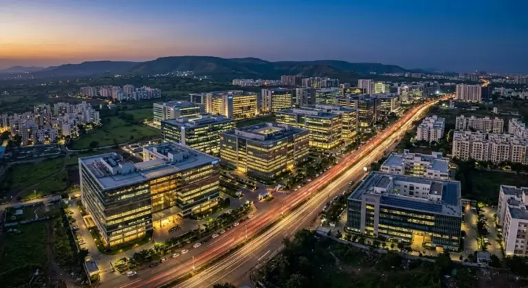
Ask why Jamshedpur grew up where it did, and the answer is sitting in the ground beneath it. India’s first integrated steel plant went up in 1907 on the Chota Nagpur plateau because that single patch of land sat within easy reach of iron ore from Singhbhum, coal from the Jharia and Raniganj fields, limestone, water from the Subarnarekha river, and a railway line to carry it all out. Steel is a weight-losing business — you burn far more raw material than the metal you end up with — so the smart move was to drag the factory to the minerals, not the minerals to the factory. Now ask why a software company in 2026 can sit in Bengaluru, Hyderabad, Pune or a converted warehouse in Gurugram with equal ease, and you get the opposite answer: it isn’t tied to anything heavy at all. Between those two stories lies the whole subject of industrial location.
Industrial location is the study of why factories settle where they do — which pulls and pushes decide whether an industry hugs a coalfield, crowds into a port city, or floats free of geography altogether. For a UPSC aspirant this sits right at the heart of economic geography in GS1, and it’s one of those topics that pays back twice: it teaches a clean set of factors and theories you can deploy on demand, and it links straight to live policy on Special Economic Zones, industrial corridors and the push to decentralise manufacturing away from a few crowded clusters. Get the logic once and you can reason your way through almost any location question, from a German economist’s triangle drawn in 1909 to where India should put its next semiconductor fab.
The Classic Determinants of Industrial Location
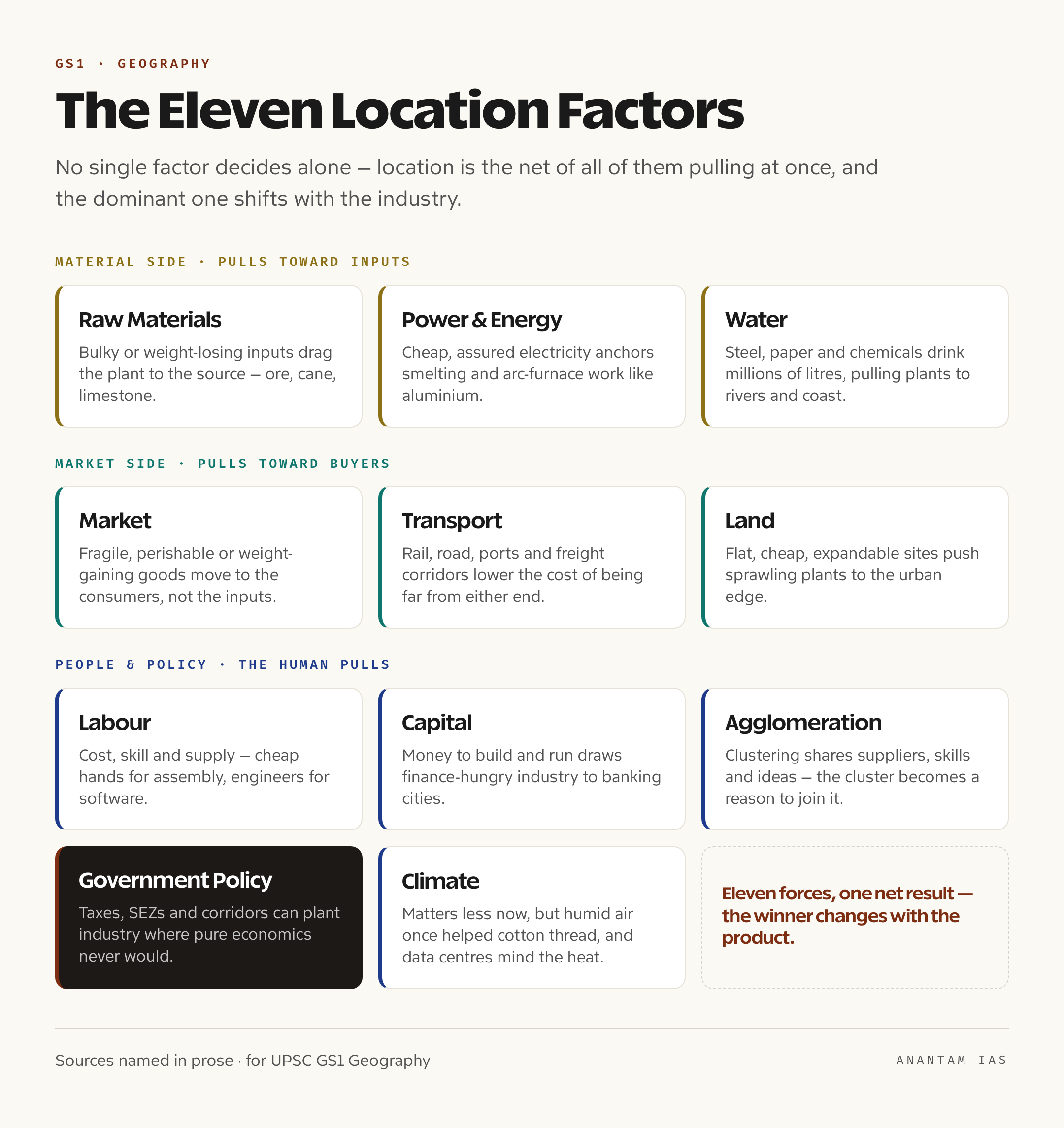
Start with the factors, because every theory and every example is just these forces fighting it out. Geographers usually count around eleven, and the trick is not to memorise a list but to see which one wins for a given industry.
The first is raw materials, the oldest pull of all. Where the inputs are bulky, heavy or perishable — iron ore, sugarcane, timber — the factory chases them to save freight, which is why sugar mills cluster in the cane belts of Uttar Pradesh and Maharashtra and why ore-based industries hug the mineral plateaus. The second is power and energy, since smelting aluminium or running an arc furnace demands enormous, cheap electricity; aluminium plants gravitate to areas with assured power, and the early jute and cotton mills first grew near coal. Third is labour — its cost, skill and supply. Cheap, abundant hands draw garment and assembly work; deep pools of engineers draw software; specialised craft skills anchor things like the brass work of Moradabad. Fourth is capital, the money to build and run the plant, which is why finance-hungry industries lean toward cities with banks, stock exchanges and venture funding.
The fifth factor is the market. Where the finished product is fragile, perishable, bulky or simply gains weight in the making — bottled drinks, bread, furniture, newspapers — the factory moves to the consumers rather than the inputs. Sixth is transport, the connective tissue that ties materials to markets; good rail, road, ports and now freight corridors lower the cost of being far from either end, which is why so much heavy industry lines up along trunk routes and coasts. Seventh is water, easy to forget until you remember that steel, paper, chemicals and thermal power all drink it by the millions of litres, pulling such plants to rivers, lakes and the coast. Eighth is land — flat, cheap, well-drained sites large enough to expand on, which is why sprawling plants push to the urban edge where land is affordable.
The ninth factor is the subtle one that explains why industries cluster: agglomeration economies. When firms gather in one place they share suppliers, repair shops, skilled labour pools, transport links and a constant exchange of ideas, so each saves money simply by being near the others. It’s why Tiruppur became a knitwear town and Surat a diamond-and-textile hub — the cluster itself becomes a reason to join the cluster. Tenth is government policy — taxes, subsidies, licences, environmental rules and, above all, deliberate incentives like SEZs and corridor projects that can plant an industry where pure economics never would. The eleventh, climate, matters less now but still counts: the humid air of Mumbai once helped cotton thread resist snapping, and temperature-sensitive work like precision instruments or data centres still cares about heat and humidity. No single factor decides alone. Location is the net result of all of them pulling at once, and the dominant one shifts with the industry.
Weber’s Least-Cost Theory and the Locational Triangle
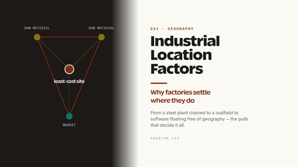
Theory enters here, and the foundation stone is Alfred Weber, a German economist whose 1909 work on the location of industries still frames how the subject is taught. Weber’s core claim is simple and powerful: a firm picks the site where its total cost is lowest, and for him the cost that mattered most was transport. Picture his famous locational triangle — two corners holding sources of raw material, the third holding the market. The factory settles at the point inside that triangle where the combined cost of hauling materials in and the product out is at its minimum, with each pull weighted by how heavy that flow is.
To predict which corner wins, Weber gave us the material index — the weight of the localised raw materials divided by the weight of the finished product. When the index is greater than one, the industry is losing weight in production (think ore-to-steel or cane-to-sugar), so it pays to sit at the raw material to avoid shipping waste, and the plant becomes material-oriented. When the index is less than one, the product is heavier or bulkier than its inputs (a soft-drink plant adding water, say), so the factory chases the market. And when it’s about one, the firm is free to sit at either end. Weber drew the cost surface with two neat tools worth naming in an answer: an isotim, a line joining points of equal transport cost for one item, and an isodapane, a line joining points of equal total transport cost. Where labour was much cheaper somewhere off the least-transport-cost point, a firm would shift — but only if the labour saving beat the extra freight, a trade-off the isodapanes let you read off the map.
Weber’s model is a deliberate simplification, and naming its limits is exactly what earns marks. It assumes a flat plain with uniform transport, fixed raw-material sources, perfect competition and a single market — none of which quite holds in the real world, where rail freight isn’t a straight line of distance, governments hand out subsidies, and markets are scattered. But the framework still does real work. It explains why India’s iron and steel industry grew on the Chota Nagpur plateau, why cement plants sit on limestone, and why sugar mills crowd the cane fields. Treat Weber as the skeleton — least cost, the triangle, the material index — and you have a tool you can apply to almost any heavy industry on demand.
Losch’s Market Area and the Rise of the Footloose Factory
Weber answered where costs are lowest, but he left a hole: he barely looked at demand. The economist who filled it was August Losch, whose work in the early 1940s flipped the question from minimising cost to maximising profit. Losch argued that a firm should locate where it can capture the largest, most profitable market, and he built an elegant geometry to show it. On an even plain each producer carves out a circular sales territory, but circles either leave gaps or overlap — so as competitors crowd in, those territories pack down into hexagons, the shape that tiles a plane with no waste. The result is Losch’s “economic landscape”, a honeycomb of market areas whose size shrinks as more firms enter. Where Weber pulls the factory toward inputs, Losch pulls it toward buyers, and the two together bracket the real choice every firm faces.
Real industries also enjoy something neither model fully prices in — agglomeration economies, the savings firms reap by clustering. Locate near rivals and suppliers and you share a trained workforce, specialised services, transport links and a flow of know-how that lifts everyone. This is the gravitational force behind industrial clusters everywhere, from the auto belt around Chennai to Silicon Valley, and it explains why firms often pile into one crowded district rather than spreading out where land is cheaper. The flip side is congestion — soaring rents, choked roads, polluted air — which eventually pushes some firms back out, the diseconomies of over-agglomeration.
Then there’s the modern wrinkle that breaks the old rules: the footloose industry, a term linked to economists William Alonso and Edgar Hoover for activities so light on transport costs that they’re free to locate almost anywhere. Microchips, software, design studios, fine instruments — their inputs and outputs are tiny in weight relative to value, so freight barely figures. Freed from raw materials and markets, these firms chase other things: skilled talent, good universities, fast connectivity, airports, pleasant living and the buzz of being near similar firms. That’s why India’s IT industry settled in Bengaluru and Hyderabad — not for any mineral but for engineering colleges, an international airport and a deep pool of coders. As more of the economy goes digital and weightless, the classic locational pulls weaken, and policy, talent and quality of life decide more and more.
How Location Logic Changes from Heavy to Hi-Tech Industry
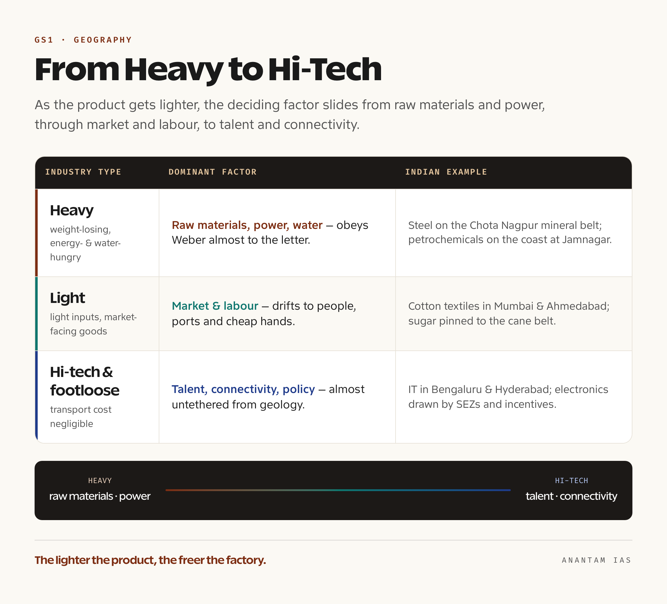
The single most useful idea here is that the dominant factor slides as the product gets lighter. Heavy industries — iron and steel, aluminium, cement, heavy chemicals, petrochemicals — are weight-losing and energy- and water-hungry, so they obey Weber almost to the letter, settling on raw materials, power and water. India’s steel plants sit on the mineral belt of Jharkhand, Odisha and Chhattisgarh; cement plants stand on limestone; and petrochemical complexes line the coast at places like Jamnagar, where imported crude lands at the port and water is on hand. For these, geography is destiny.
Light industries make goods that weigh little but serve big consumer markets — packaged food, garments, electronics assembly, consumer goods. Their inputs are light and their products are often perishable, fragile or market-gaining, so they drift toward population centres, cheap labour and good transport rather than mines. India’s cotton textile mills grew in Mumbai and Ahmedabad for a telling mix of reasons: humid coastal air that kept thread from snapping, port access for machinery and cotton, capital from the trading houses, and a large labour force and home market close by. Sugar — heavy, perishable cane that must be crushed within hours of cutting — stays glued to the fields of western Uttar Pradesh and the Maharashtra cane belt, a reminder that perishability can pin even a “light” product to its source.
Hi-tech and footloose industries sit at the far end, almost untethered. Software, semiconductors, biotech, aerospace design and precision instruments care little for ore or coal and everything for brains, bandwidth and a good airport. They cluster in knowledge hubs — Bengaluru, Hyderabad, Pune, the Gurugram-Noida belt — drawn by universities, skilled migrants, venture capital and the agglomeration buzz of peers next door. So as you climb from steel to software, the deciding factor migrates from raw materials and power, through market and labour, to talent, infrastructure and policy. Hold that gradient in your head and you can place almost any industry without memorising a single case.
SEZs, Industrial Corridors and India’s Push to Decentralise
Left to pure economics, industry concentrates — a handful of mineral belts, port cities and metros end up with everything, while vast regions stay industrially empty. India has spent decades trying to bend that outcome, because lopsided industrialisation widens regional inequality and overloads a few cities. The earliest tools were freight-equalisation and licensing policies that subsidised the movement of coal and steel so plants could be set up far from the coalfields, and a deliberate spread of public-sector steel and heavy-engineering units into the interior. The results were mixed, but the intent — pull industry toward backward regions — has never gone away.
The modern instruments are sharper. Special Economic Zones, governed by the SEZ Act of 2005, are enclaves with duty-free imports, tax breaks and lighter regulation, designed to draw export-oriented and footloose industry to chosen sites; they’re a textbook case of government policy overriding natural locational pulls. Bigger still are the industrial corridors, which try to engineer location at the scale of whole regions. The flagship is the Delhi-Mumbai Industrial Corridor, a roughly 1,483-kilometre belt cutting across six states, anchored on a dedicated freight railway and backed financially and technically by Japan, with a string of planned smart cities and investment nodes like Dholera in Gujarat. As the implementing agency describes it, the corridor bundles freight rail, ports, power and ready industrial land so that manufacturing can take root along the spine rather than only at the old clusters. Other corridors — Chennai-Bengaluru, Amritsar-Kolkata, Bengaluru-Mumbai — extend the same logic across the map.
And the deepest shift is the one technology is driving on its own. As industry goes digital and footloose, the old anchors loosen, and that hands policy a real opening: if software, electronics and services aren’t tied to minerals, then talent, connectivity and incentives can put them almost anywhere a state is willing to build the ecosystem. That’s the promise behind data centres spreading beyond Mumbai, electronics plants rising in Tamil Nadu and the north, and semiconductor projects courted with subsidies. The classic factors still rule heavy industry, but for the fast-growing weightless economy, government policy and human capital are quietly becoming the decisive location factors of the century.
For Your Mains Answer
This is a core topic for GS Paper 1, which covers the distribution of key natural resources and the location of primary, secondary and tertiary industries across India and the world, plus the factors behind their location. It also feeds GS Paper 3 wherever questions touch manufacturing policy, regional development or industrial corridors. The examiner’s reward goes to the candidate who can name the factors crisply, deploy at least one theory by name, and then ground both in sharp Indian examples — exactly the spine this article follows.
How to Build the Answer
Move from factor to theory to example, in that order. Open by defining industrial location and listing the determinants in quick groups — material-side (raw materials, power, water), market-side (market, transport), and people-and-policy (labour, capital, agglomeration, government, climate). Then bring in theory: Weber for least cost and the material index, Losch for market area and profit, the footloose concept for the modern exception. Close every limb with an Indian example so the answer never floats — steel on Chota Nagpur, cotton in Mumbai-Ahmedabad, IT in Bengaluru, sugar in the cane belt. End by judging how SEZs, corridors and the digital shift are rewriting the old rules.
Common Mistakes to Avoid
Don’t just dump all eleven factors with equal weight — the marks are in showing which one dominates for which industry. Don’t confuse the theorists: Weber minimises cost, Losch maximises profit through market area. Don’t forget the material index direction — index above one means material-oriented, below one means market-oriented; reversing it is a classic slip. And don’t treat footloose industry as a vague buzzword; tie it to low transport cost and the pull of talent and connectivity, with Bengaluru as proof.
A Compact Answer Spine
Location = net of eleven factors (raw materials, power, labour, capital, market, transport, water, land, agglomeration, policy, climate) → Weber’s least cost: locational triangle + material index (>1 material-oriented, <1 market-oriented), isotim/isodapane → Losch: profit maximisation, hexagonal market areas → footloose industry (Alonso/Hoover): transport cost negligible, chases talent + connectivity → gradient: heavy = raw materials/power (steel on Chota Nagpur), light = market/labour (cotton in Mumbai-Ahmedabad), hi-tech = talent (IT in Bengaluru) → policy layer: SEZ Act 2005, DMIC (~1,483 km, six states, Japan-backed) → verdict: classic pulls still rule heavy industry, but policy and human capital now decide the weightless economy.
Diagram or Flowchart Idea
Sketch Weber’s locational triangle — two raw-material corners, one market corner, the plant at the least-cost point inside — and beside it a simple gradient bar running heavy industry → light industry → hi-tech, with the dominant factor labelled under each (raw materials/power → market/labour → talent/connectivity). That pairing shows you know both the theory and the modern shift in one glance.
A Balanced-Conclusion Line
A line that lands the marks: “Industrial location was once written by geology and freight, but as industry turns digital and footloose, the deciding hand is shifting from the coalfield to the campus — and from nature to deliberate policy through SEZs and corridors.”
How to Use Data Without Cramming
You need only a few anchors, not a gazetteer: Weber’s 1909 theory, the material index rule (>1 versus <1), the SEZ Act of 2005, and the DMIC's headline shape — roughly 1,483 km across six states with Japanese backing. Attach each to the right point and the answer reads as informed. Attribute plainly — "as the corridor's implementing agency describes it" — rather than scattering loose numbers.
FAQ
What are the main factors that decide industrial location? The classic set runs to about eleven: raw materials, power and energy, labour, capital, market, transport, water, land, agglomeration economies, government policy and climate. No single factor decides on its own — location is the net result of all of them pulling at once, and the dominant one changes with the industry. Heavy industry leans on raw materials, power and water; light industry on market and labour; hi-tech on talent and connectivity.
What is Weber’s least-cost theory of industrial location? Alfred Weber argued in 1909 that a firm locates where its total cost, chiefly transport cost, is lowest. His locational triangle places raw-material sources at two corners and the market at the third, with the plant settling at the least-cost point inside. His material index — weight of raw materials divided by weight of product — predicts the pull: above one means material-oriented, below one means market-oriented.
What is a footloose industry, and why does it matter? A footloose industry is one whose transport costs are so low that it can locate almost anywhere — software, microchips, design and precision work, where inputs and outputs are tiny in weight relative to value. The term is linked to economists William Alonso and Edgar Hoover. Freed from raw materials and markets, these firms chase skilled talent, universities, connectivity and quality of life, which is why India’s IT industry settled in Bengaluru and Hyderabad rather than near any mine.
How is India trying to decentralise industry away from a few clusters? Through deliberate policy. Special Economic Zones under the SEZ Act of 2005 offer tax breaks and lighter regulation to draw export-oriented industry to chosen sites, and industrial corridors engineer location at regional scale — the flagship Delhi-Mumbai Industrial Corridor runs about 1,483 km across six states with Japanese backing, bundling freight rail, ports and ready industrial land. As industry goes digital and footloose, policy and human capital have growing power to place industry where pure economics never would.
Practice Questions
Prelims MCQs
- According to Alfred Weber’s least-cost theory, an industry with a material index greater than one will tend to be located where?
(a) Near the market for the finished product
(b) At the source of the raw material
(c) Midway between raw material and market
(d) Wherever labour is cheapest
Answer: (b) A material index above one means the industry loses weight in production, so it locates at the raw material to avoid shipping waste, becoming material-oriented. - In Weber’s model of industrial location, the term “isodapane” refers to which of the following?
(a) A line joining points of equal rainfall
(b) A line joining points of equal transport cost for a single commodity
(c) A line joining points of equal total transport cost
(d) A line joining points of equal labour cost
Answer: (c) An isodapane joins points of equal total transport cost, while an isotim joins points of equal transport cost for one item. - The concept of hexagonal market areas in industrial and settlement location is most closely associated with which economist?
(a) Alfred Weber
(b) August Losch
(c) Johann von Thunen
(d) Edgar Hoover
Answer: (b) August Losch developed the market-area approach built on profit maximisation and the honeycomb of hexagonal market areas, the “economic landscape”. - Which of the following best characterises a “footloose industry”?
(a) An industry strictly tied to mineral deposits
(b) An industry whose transport costs are negligible, allowing it to locate almost anywhere
(c) An industry that must locate on the coast for water
(d) An industry dependent on perishable raw materials
Answer: (b) A footloose industry has very low transport costs relative to product value, so it is free to chase talent, connectivity and quality of life rather than raw materials or markets. - The Delhi-Mumbai Industrial Corridor (DMIC) is correctly described by which statement?
(a) It is a roughly 1,483-km corridor across six states, anchored on a dedicated freight railway and backed by Japan
(b) It is a coastal corridor linking Chennai and Kolkata funded by the World Bank
(c) It is a power-transmission corridor with no industrial component
(d) It is a corridor confined entirely to the state of Gujarat
Answer: (a) The DMIC spans about 1,483 km across six states, is built around a dedicated freight corridor with financial and technical backing from Japan, and includes planned investment nodes like Dholera.
Mains Practice Questions
- “Industrial location is the net result of several factors pulling at once, and the dominant one shifts with the industry.” Discuss with reference to heavy, light and hi-tech industries in India. (15 marks, 250 words)
- Critically examine Alfred Weber’s least-cost theory of industrial location. How far does it explain the location of India’s iron and steel and cement industries? (15 marks, 250 words)
- Compare Weber’s least-cost approach with August Losch’s market-area approach to industrial location. Which is more relevant to understanding modern footloose industries? (15 marks, 250 words)
- What are footloose industries? Explain the factors influencing their location and why they have weakened the classic locational pulls of raw materials and markets. (10 marks, 150 words)
- Evaluate the role of government policy — through Special Economic Zones and industrial corridors such as the DMIC — in decentralising industry in India. (15 marks, 250 words)
Tell Google you want more of this.
Add Anantam IAS as a preferred sourceOne tap, and this site shows up more often in your own Top Stories, AI Overviews and AI Mode. Remove it any time.