Most aspirants can recite “Himadri, Himachal, Shiwalik” but freeze when an MCQ asks which range Pir Panjal belongs to, or which is older, the Aravalli or the Himalayas. The names blur together because they are usually memorized as a flat list, with no sense of where the ranges sit, how they were born, or why one is jagged and snow-capped while another is a worn green ridge. That gap is exactly where Prelims questions live.
India’s mountains fall into two clean families: the young, towering Himalayas in the north, thrown up where the Indian plate is still grinding into Asia, and the ancient, worn-down Peninsular ranges in the south, which are among the oldest landforms on Earth. Get that one distinction firm and almost everything else, the peaks, the passes, the rivers that drain off them, slots into place. This is one of the highest-frequency map topics in the UPSC Prelims, and it quietly underpins half of physical geography.
Why India Has Two Completely Different Mountain Families
India’s two mountain systems differ because they were made in completely different ways, at completely different times. The Himalayas are fold mountains, crumpled up like a tablecloth pushed across a table, formed when the Indian plate collided with the Eurasian plate roughly 50 million years ago. That collision is still happening, which is why the Himalayas are tall, sharp, and seismically active. The peninsular ranges are residual or block mountains, the eroded stumps of far older highlands sitting on one of the planet’s most stable land masses, the Deccan plateau.
“Fold mountain” just means rock layers buckled into folds by compression, the way a rug bunches when you shove it. “Block mountain” means a chunk of crust lifted or left standing between cracks called faults, the way the Satpura sits between two rift valleys. “Residual” means what is left after millions of years of erosion wore everything else down, which is what the Aravalli is today. The smart thing to notice is that age maps onto shape: young Himalayas are pointed and snow-clad because erosion has not had time to round them; the Aravalli is a low, rolling ridge because it has been weathering since before complex life existed.
This split also decides drainage, and that is a favourite linkage in Mains answers. The Himalayas feed perennial, snow-and-glacier-fed rivers like the Ganga, Yamuna, and Brahmaputra, which keep flowing even in summer. The peninsular ranges feed rain-dependent rivers like the Godavari, Krishna, and Narmada, which can run thin in the dry months. If you want the river side of this story in depth, our explainer on the drainage systems of India builds directly on these watersheds.
The Himalayas: Three Parallel Ranges, West to East
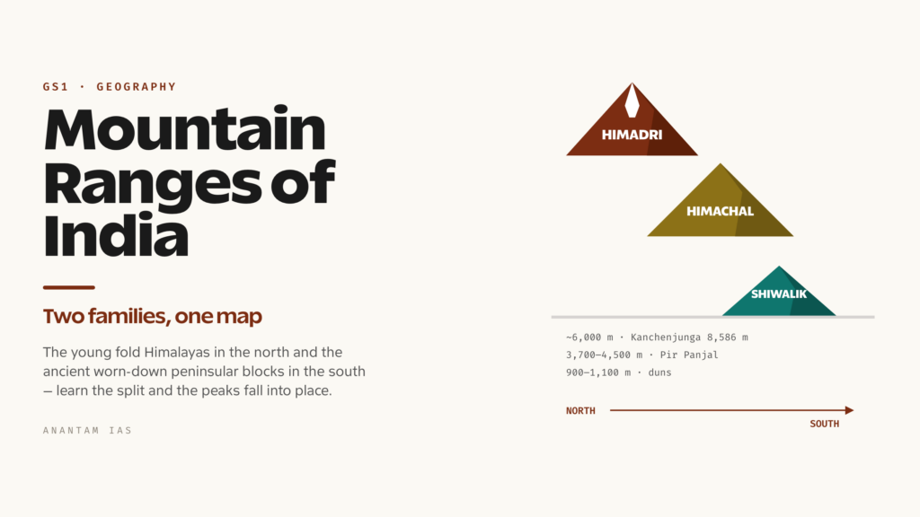
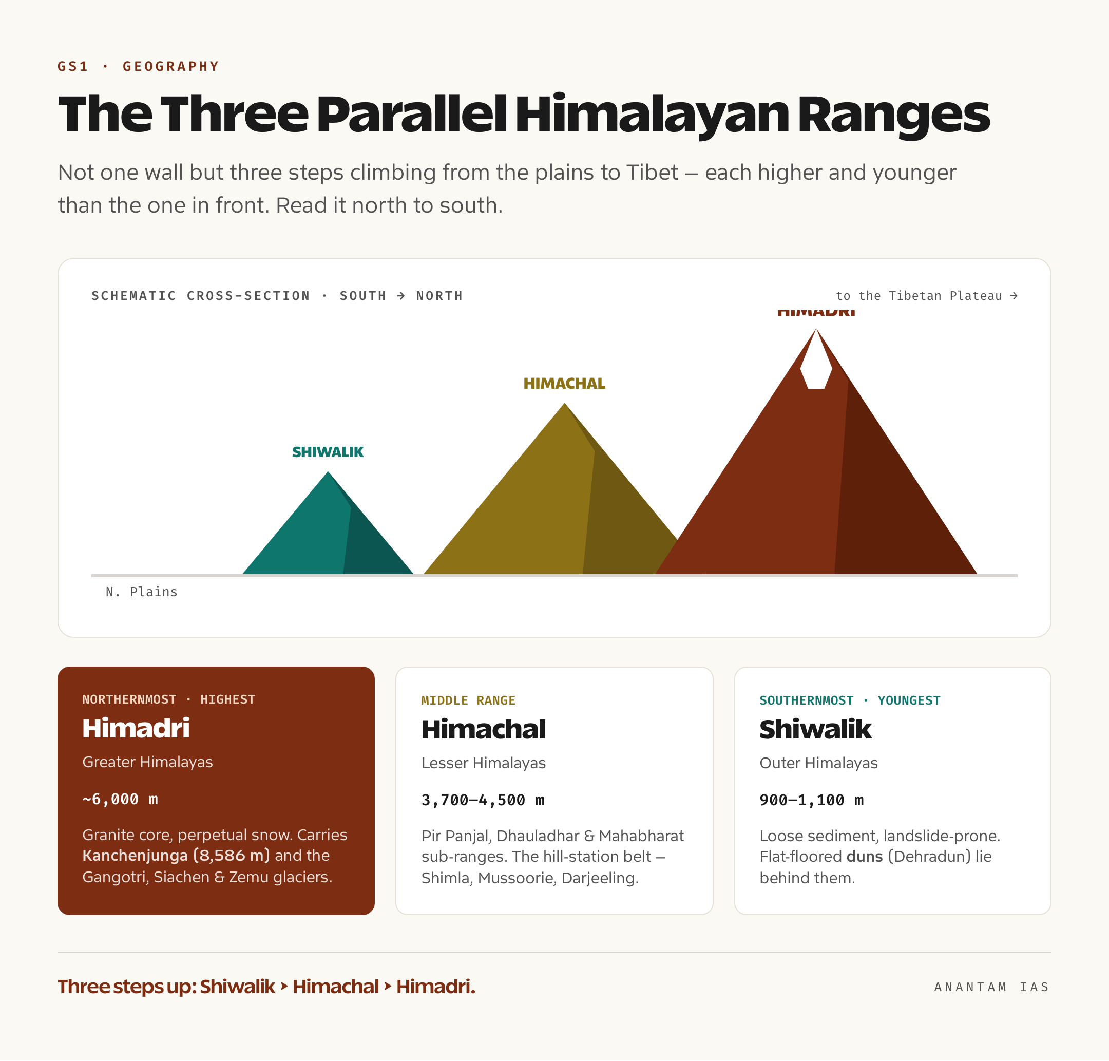
The Himalayas are not one wall but three roughly parallel ranges running north-west to south-east, each lower and younger than the one behind it. From north to south they are the Greater Himalayas (Himadri), the Lesser Himalayas (Himachal), and the Outer Himalayas (Shiwaliks). Picture three steps climbing from the plains up to the Tibetan plateau, and you have the structure that examiners test again and again.
Himadri (Greater Himalayas)
The Himadri is the northernmost, highest, and most continuous range, holding the loftiest peaks on Earth. Its average height is around 6,000 metres, and it carries the giants: Kanchenjunga (8,586 m), the highest peak entirely within India, on the Sikkim-Nepal border, along with Everest and Makalu just beyond the border in Nepal. This range has a granite core, is permanently snow-covered, and is the source of the great glaciers, Gangotri, Siachen, Zemu, that feed north India’s rivers.
Himachal (Lesser Himalayas)
The Himachal lies just south of the Himadri, with heights between 3,700 and 4,500 metres. This is the range of the famous sub-ranges: the Pir Panjal (the longest, in Kashmir), the Dhauladhar (Himachal Pradesh), and the Mahabharat (Nepal). It is also where the hill stations sit, Shimla, Mussoorie, Nainital, Darjeeling, because the altitude is high enough to be cool but low enough to be habitable. The lush summer pastures here have local names worth knowing: Margs in Kashmir (Gulmarg, Sonamarg) and Bugyals in Uttarakhand.
Shiwaliks (Outer Himalayas)
The Shiwaliks are the southernmost, lowest, and youngest range, only 900 to 1,100 metres high. They are made of unconsolidated sediment, gravel and silt washed down from the rising mountains above, which makes them prone to landslides. Their signature landform is the dun (or doon): a flat-floored longitudinal valley between the Shiwaliks and the Lesser Himalayas, formed where rivers dumped their load. Dehradun is the textbook example, and duns are a reliable one-mark question.
The Himalayas also divide neatly from west to east into four regional sections, defined by the rivers that cut across them. From west to east: the Punjab/Kashmir Himalayas (between the Indus and the Sutlej), the Kumaon Himalayas (Sutlej to Kali), the Nepal Himalayas (Kali to Tista, holding the tallest peaks), and the Assam Himalayas (Tista to Dihang). The eastern syllabus then bends sharply south into the Purvanchal, the hills of the north-east, where the Himalayas turn and run down India’s border with Myanmar: the Patkai Bum, the Naga Hills, the Manipur Hills, and the Mizo (Lushai) Hills. These are lower, forested, and folded into the same plate collision, just rotated south. For the bigger picture of how this whole arc formed and behaves, see our deep dive on the Himalayas.
The Peninsular Ranges: Old, Worn, and Often Underrated
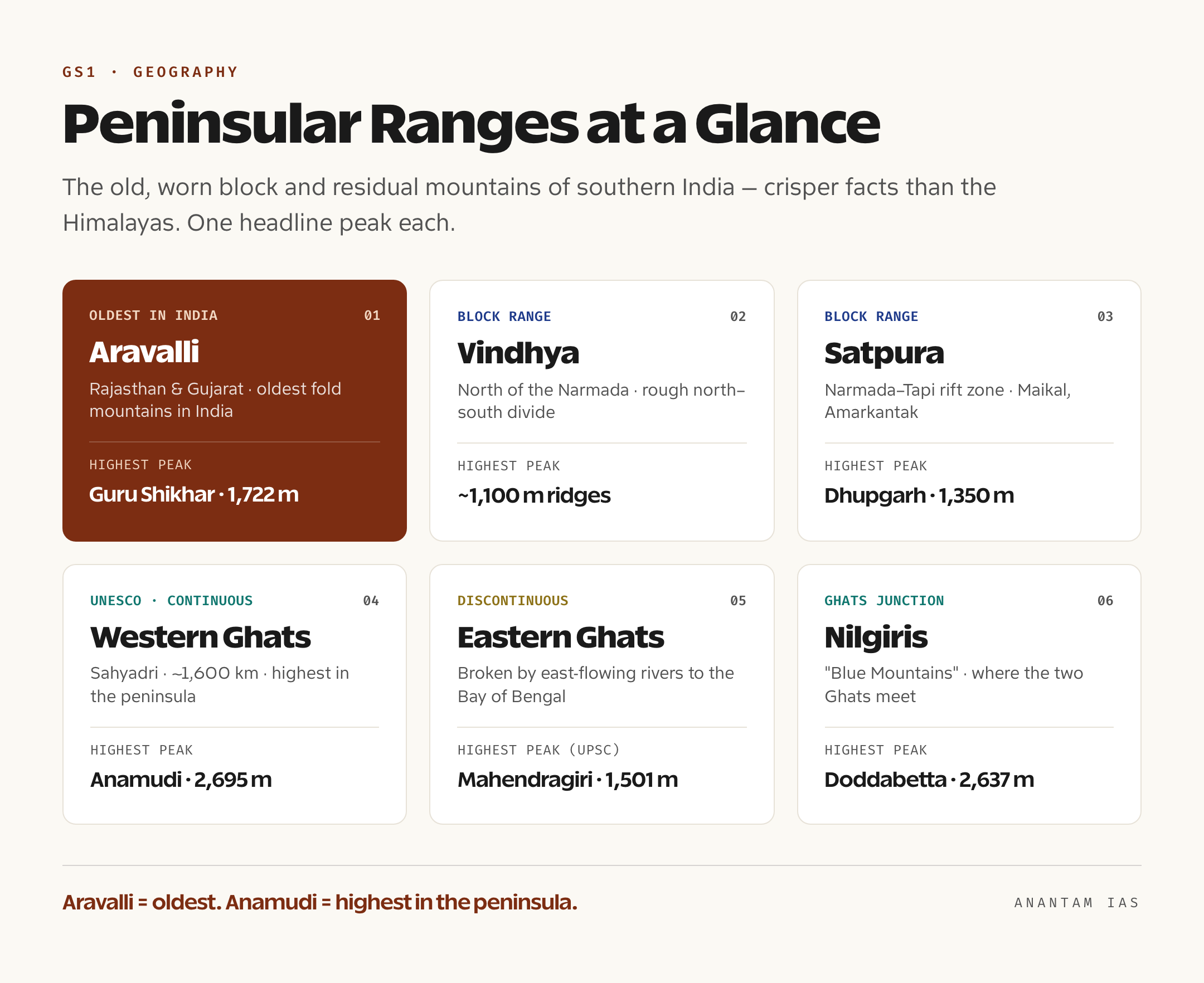
The peninsular ranges are the ancient block and residual mountains of southern India, and aspirants routinely underweight them because they look unimpressive on a map. That is a mistake. They generate as many questions as the Himalayas, partly because their facts are crisper, one oldest range, one highest peak, two ghats. The peninsula’s mountains frame the Deccan plateau like a tilted table: high in the west, sloping gently east.
The single most-tested fact here is age. The Aravalli Range in Rajasthan and Gujarat is the oldest fold mountain system in India, and among the oldest on Earth, worn down over hundreds of millions of years to a low ridge. Its highest point is Guru Shikhar (1,722 m) on Mount Abu, Rajasthan’s only hill station. If a question pairs “oldest” with a range, the answer is the Aravalli, and you should be able to say so without hesitating.
Running across central India are two more block ranges that act as the rough divide between the Gangetic north and the peninsular south. The Vindhya Range lies north of the Narmada, and the Satpura Range lies south of it, between the Narmada and Tapi rift valleys. The Satpura’s highest point, and a frequent MCQ, is Dhupgarh (1,350 m) in the Mahadeo Hills, but the more famous spot is Amarkantak in the Maikal Hills (the eastern arm of the Satpura), where both the Narmada and the Son rivers rise.
The Western Ghats (Sahyadri)
The Western Ghats, or Sahyadri, run almost continuously for about 1,600 km down the western edge of the peninsula, from the Tapi valley to Kanyakumari, and they are far more significant than their modest height suggests. They are the highest of the peninsular ranges and a UNESCO World Heritage Site, recognized as one of the world’s eight “hottest” biodiversity hotspots. The highest peak in the entire peninsula, Anamudi (2,695 m) in Kerala, sits here. Because they are continuous, you cross them through named passes (ghats): the Thal Ghat and Bhor Ghat in Maharashtra, and the Palghat (Palakkad) Gap in Kerala, the single biggest break in the wall and a major road, rail, and monsoon corridor. The Ghats also force the south-west monsoon to rise and rain, which is why their windward side is drenched and the Deccan interior sits in a rain shadow. Our Western Ghats explainer covers the ecology and the hotspot status in full.
The Eastern Ghats and the Nilgiris
The Eastern Ghats are the opposite of the Western Ghats in almost every way: low, discontinuous, broken into detached hill clusters by the great east-flowing rivers (the Mahanadi, Godavari, Krishna, and Kaveri) that cut through them to reach the Bay of Bengal. The traditional UPSC peak here is Mahendragiri (1,501 m) in Odisha, though the technically highest summit is Arma Konda (Jindhagada Peak, around 1,690 m) in Andhra Pradesh. The two ghats meet in the south at the Nilgiri Hills (“Blue Mountains”), whose highest peak is Doddabetta (2,637 m), the famous junction point of the Western and Eastern Ghats. This meeting forms the high horseshoe around the Palghat Gap, and the connected uplands feed the peninsular plateau that fills the rest of southern India.
Here is the whole system in one view. Read down the “Type” column first, that fold-versus-block split is the spine of the topic.
| Range | Type | Location | Highest Peak | Note |
|---|---|---|---|---|
| Himadri (Greater Himalayas) | Fold (young) | Northernmost Himalayan range | Kanchenjunga (8,586 m) | Highest, continuous, perpetually snow-covered |
| Himachal (Lesser Himalayas) | Fold (young) | South of Himadri | Pir Panjal peaks (~5,000 m) | Pir Panjal, Dhauladhar, Mahabharat; hill stations |
| Shiwaliks (Outer Himalayas) | Fold (young) | Southernmost, foothills | ~1,100 m ridges | Made of loose sediment; “duns” lie behind them |
| Purvanchal (NE hills) | Fold (young) | North-east, Myanmar border | Saramati (~3,800 m) | Patkai, Naga, Manipur, Mizo hills |
| Aravalli | Residual fold (oldest) | Rajasthan, Gujarat | Guru Shikhar (1,722 m) | Oldest fold mountains in India |
| Vindhya | Block | North of the Narmada | ~1,100 m | Rough north-south cultural divide |
| Satpura | Block | Narmada-Tapi rift zone | Dhupgarh (1,350 m) | Maikal/Amarkantak; source of Narmada and Son |
| Western Ghats (Sahyadri) | Block (faulted edge) | Western peninsular margin | Anamudi (2,695 m) | UNESCO hotspot; highest in peninsular India |
| Eastern Ghats | Residual | Eastern peninsular margin | Mahendragiri (1,501 m) | Discontinuous; cut by east-flowing rivers |
| Nilgiris | Block | Western-Eastern Ghats junction | Doddabetta (2,637 m) | Where the two Ghats meet |
The Must-Know Peaks and Passes
For Prelims, a handful of peaks and passes come up so often that they are worth memorizing cold, with their states and ranges attached. The trap is mixing up “highest in India” with “highest in the world” or “highest peninsular” peaks, so fix the hierarchy first.
On peaks: Kanchenjunga (8,586 m) is the highest peak entirely inside India (in Sikkim) and the world’s third-highest mountain. K2 (8,611 m) is technically taller and lies in Pakistan-occupied Kashmir (PoK), which India claims, so it appears in some lists with an asterisk. Nanda Devi (7,816 m) is the highest peak located wholly within an Indian state (Uttarakhand). Then the peninsular set: Anamudi (2,695 m) is the highest in peninsular/South India, Doddabetta (2,637 m) the highest in the Nilgiris, and Guru Shikhar (1,722 m) the highest in the Aravalli. Memorize those six and you have covered most of what gets asked.
On passes: in the western Himalayas, Zoji La links Srinagar to Leh, Banihal (with the Jawahar tunnel) connects the Kashmir valley to Jammu, and Shipki La and Rohtang sit in Himachal. In the east, Nathu La and Jelep La connect Sikkim to Tibet, and Bomdi La lies in Arunachal Pradesh. In the peninsula, the passes are the Western Ghats gaps, Thal Ghat, Bhor Ghat, Palghat. For a fuller treatment of which pass connects what and why each matters strategically, work through our dedicated note on mountain passes of India.
How to Study This for UPSC
Start with the two-family split, then layer detail onto a map, never onto a list. This topic rewards visual memory, so the worst way to learn it is reading names in a row; the best way is drawing them.
Read in this order. First, get the fold-versus-block distinction and the age contrast (Himalayas young, Aravalli oldest) absolutely firm, because most conceptual questions hang off it. Second, fix the three Himalayan ranges north-to-south and their one defining feature each (Himadri = highest peaks, Himachal = hill stations and Pir Panjal, Shiwaliks = duns). Third, learn the peninsular ranges by their headline fact (Aravalli = oldest, Western Ghats = UNESCO and Anamudi, Eastern Ghats = discontinuous). Fourth, drill the six must-know peaks and the major passes. Then practise on a blank outline map until you can place every range and peak from memory. For the standard reference, the relevant chapters of the NCERT “India: Physical Environment” (Class 11) cover this exactly, and they are enough; you do not need a thicker book for Prelims-level mountains.
How it is tested splits cleanly. Prelims loves precise, isolated facts: which range is oldest, which pass connects two places, the order of ranges, the highest peak of a region, match-the-following between peaks and states. Mains rarely asks the names directly; instead it asks you to use them, in answers on the monsoon and rain shadow, on river systems, on Himalayan seismicity and disasters, or on the ecological stress on the Western Ghats. So memorize for Prelims, but understand the linkages for Mains. If you are still building your foundation, our broader Indian geography hub sequences these physical topics in the order that actually makes them stick.
Frequently Asked Questions
Which is the highest mountain peak in India? Kanchenjunga, at 8,586 metres, is the highest peak lying entirely within India (on the Sikkim-Nepal border) and the world’s third-highest mountain. K2 (8,611 m) is taller but is located in Pakistan-occupied Kashmir, which India claims. Nanda Devi (7,816 m) is the highest peak wholly inside an Indian state, Uttarakhand.
What is the difference between fold mountains and block mountains? Fold mountains form when rock layers are compressed and buckled into folds, like the Himalayas crumpling up as the Indian plate pushes into Asia. Block mountains form when a chunk of crust is lifted or left standing between faults (cracks), like the Satpura sitting between two rift valleys. Fold mountains tend to be young and tall; the peninsular blocks are old and worn.
Why are the Himalayas higher and sharper than the peninsular ranges? Because they are far younger. The Himalayas rose only about 50 million years ago and are still rising, so erosion has not had time to round them, and they remain pointed and snow-capped. The peninsular ranges, like the Aravalli, are hundreds of millions of years old and have been worn down to low ridges.
Which is the oldest mountain range in India? The Aravalli Range in Rajasthan and Gujarat is the oldest fold mountain system in India and among the oldest on Earth. Its highest point is Guru Shikhar (1,722 m) on Mount Abu. This “oldest range” fact is a very common Prelims question.
What are the three parallel ranges of the Himalayas? From north to south: the Himadri (Greater Himalayas), the highest and the one carrying peaks like Kanchenjunga; the Himachal (Lesser Himalayas), holding the Pir Panjal and Dhauladhar and most hill stations; and the Shiwaliks (Outer Himalayas), the lowest foothills, behind which lie the flat valleys called duns.
Practice Questions
Prelims MCQs
- Which of the following is the oldest fold mountain system in India? (a) Shiwaliks (b) Satpura (c) Aravalli (d) Vindhya. Answer: (c) The Aravalli is the oldest fold mountain range in India and among the oldest in the world.
- Arrange the three Himalayan ranges from north to south. (a) Shiwalik, Himachal, Himadri (b) Himadri, Himachal, Shiwalik (c) Himachal, Himadri, Shiwalik (d) Himadri, Shiwalik, Himachal. Answer: (b) The Himadri (Greater) is northernmost and highest, then the Himachal (Lesser), then the Shiwaliks (Outer/foothills).
- The Pir Panjal and Dhauladhar ranges belong to which division of the Himalayas? (a) Greater Himalayas (b) Lesser Himalayas (c) Outer Himalayas (d) Trans-Himalayas. Answer: (b) Pir Panjal, Dhauladhar and Mahabharat are sub-ranges of the Lesser Himalayas (Himachal).
- The highest peak in peninsular India is (a) Doddabetta (b) Guru Shikhar (c) Anamudi (d) Mahendragiri. Answer: (c) Anamudi (2,695 m) in the Western Ghats, in Kerala, is the highest peak in peninsular and South India.
- The flat-floored valleys lying between the Shiwaliks and the Lesser Himalayas are called (a) margs (b) bugyals (c) duns (d) doabs. Answer: (c) Duns (such as Dehradun) are longitudinal valleys formed by river deposition behind the Shiwaliks.
Mains Practice Questions
- The Himalayas and the peninsular ranges of India differ fundamentally in origin, age, and form. Examine these differences and their implications for the country’s rivers and climate. (15 marks, 250 words)
- “The Western Ghats are ecologically far more significant than their height suggests.” Discuss with reference to their biodiversity, monsoon role, and conservation challenges. (15 marks, 250 words)
- Account for the contrast between the continuous Western Ghats and the discontinuous Eastern Ghats, and explain the geographical consequences of this difference. (10 marks, 150 words)
- The Shiwaliks, though the lowest Himalayan range, pose distinct hazards and opportunities. Analyse. (10 marks, 150 words)
- Discuss how India’s major mountain passes have shaped its trade, defence, and connectivity, with suitable examples from the Himalayan and peninsular regions. (15 marks, 250 words)
If you take one thing from this, let it be the shape, not the list. Once you can close your eyes and see three Himalayan steps rising in the north and a tilted Deccan table framed by ghats in the south, the names stop being something you cram and start being something you simply read off a mental map. That is the difference between an aspirant who loses a mark to a tricky pass question and one who places it instantly. Draw the map a few times this week, attach the six peaks and the major passes, and this whole high-frequency topic turns into reliable, easy marks.
Tell Google you want more of this.
Add Anantam IAS as a preferred sourceOne tap, and this site shows up more often in your own Top Stories, AI Overviews and AI Mode. Remove it any time.