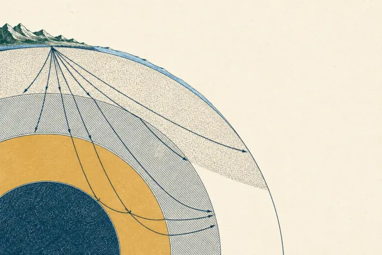
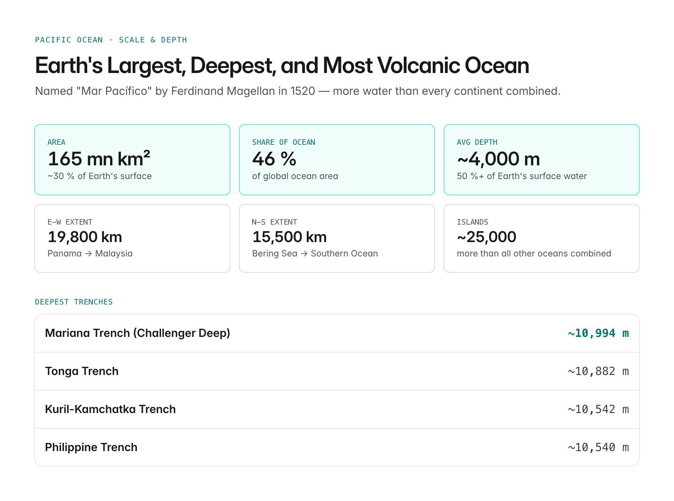
The Pacific Ocean is the largest and deepest ocean on Earth, covering about 165 million sq km — more than all land surface combined — and reaching a maximum depth of ~11,000 m at the Mariana Trench. Bordered by Asia, Australia, and the Americas, it stretches from the Arctic to the Southern Ocean. The Pacific hosts over half the world's free water, shapes global climate through phenomena like El Niño, and is the theatre of the Indo-Pacific strategic construct central to modern geopolitics. This guide covers the Pacific's physical geography, currents, resources, and strategic significance for UPSC Geography and International Relations.
Name, Extent, and Basic Facts
- Named Mar Pacífico ("peaceful sea") by Ferdinand Magellan in 1520.
- Covers about 30% of Earth's surface and 46% of the world's ocean area.
- East–west extent from Panama to Malaysia: about 19,800 km.
- North–south extent from Bering Sea to Southern Ocean: about 15,500 km.
- Average depth: approximately 4,000 m.
- Holds more than 50% of the total water on Earth's surface.
The International Hydrographic Organization divides the Pacific into the North Pacific and South Pacific along the Equator.
Bathymetry and the Ring of Fire
The Pacific is ringed by the "Pacific Ring of Fire", the world's most active seismic and volcanic zone.
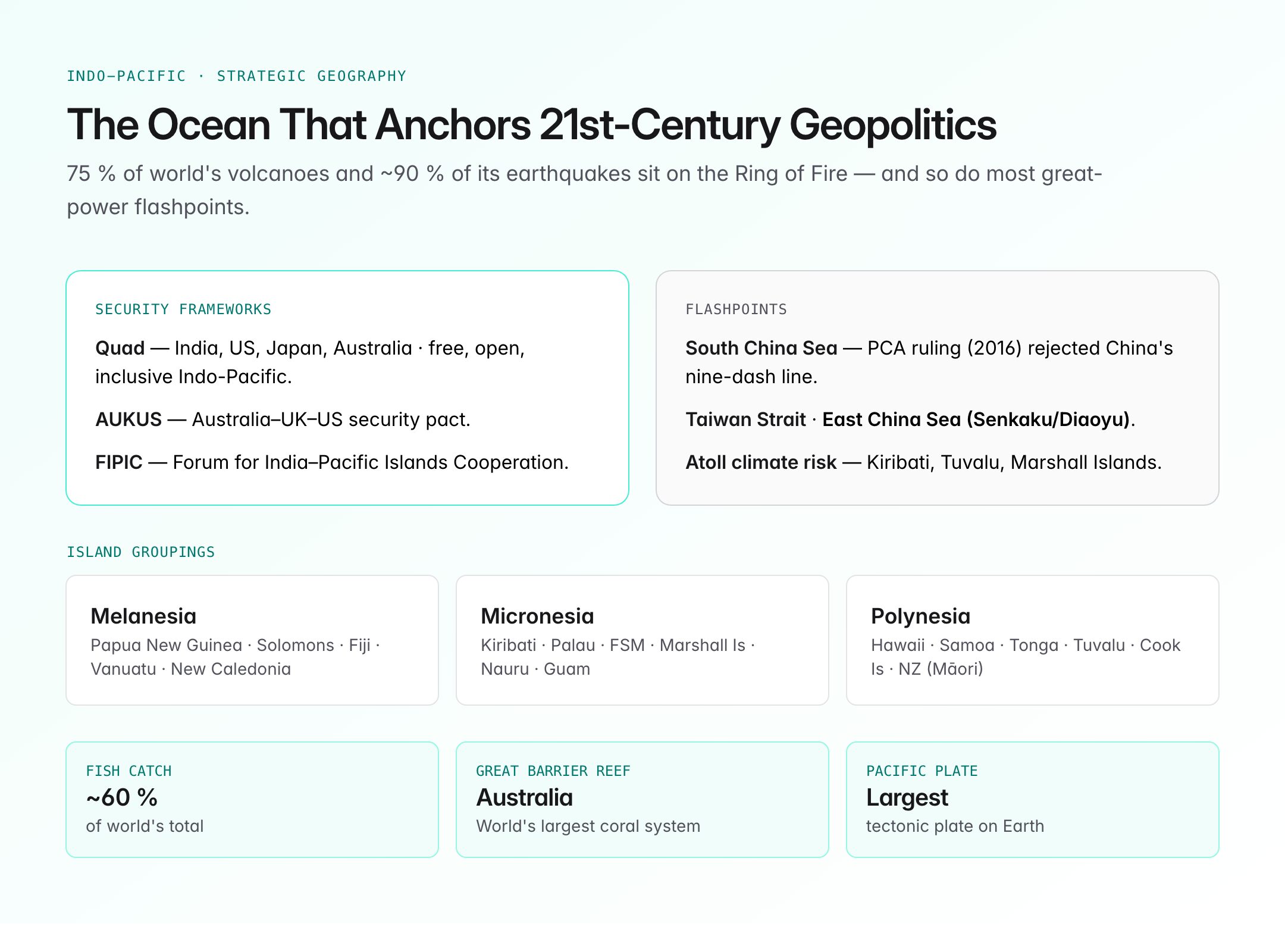
- About 75% of the world's volcanoes and ~90% of earthquakes occur along this horseshoe-shaped belt.
- The Pacific Plate is the largest tectonic plate on Earth.
- Subduction zones along the edges create deep oceanic trenches such as:
| Trench | Maximum Depth |
|---|---|
| Mariana Trench (Challenger Deep) | ~10,994 m |
| Tonga Trench | ~10,882 m |
| Philippine Trench | ~10,540 m |
| Kuril-Kamchatka Trench | ~10,542 m |
- The East Pacific Rise is a mid-ocean ridge system where new oceanic crust is created.
Major Islands and Island Groups
The Pacific has an estimated 25,000 islands, more than in all other oceans combined. They are culturally and geographically grouped as:
- Melanesia: Papua New Guinea, Solomon Islands, Fiji, Vanuatu, New Caledonia.
- Micronesia: Kiribati, Palau, Federated States of Micronesia, Marshall Islands, Nauru, Guam.
- Polynesia: Hawaii, Samoa, Tonga, Tuvalu, Cook Islands, French Polynesia, New Zealand (Māori Polynesia).
Islands include continental fragments (New Zealand), volcanic high islands (Hawaii), and coral atolls (Kiribati, Marshall Islands).
Marginal Seas and Gulfs
Important marginal seas include the Bering Sea, Sea of Okhotsk, Sea of Japan (East Sea), Yellow Sea, East China Sea, South China Sea, Philippine Sea, Coral Sea, and Tasman Sea. The Gulf of Alaska and Gulf of California are significant northern embayments.
Ocean Currents
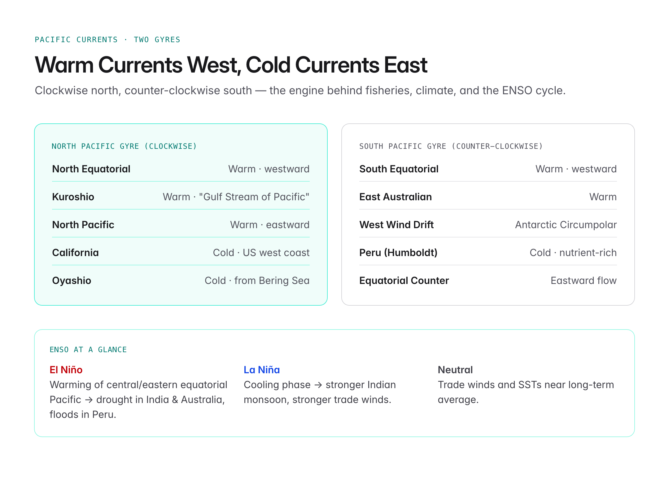
Pacific currents form two major gyres — clockwise in the Northern Hemisphere, counter-clockwise in the Southern.
North Pacific Gyre:
- North Equatorial Current (westward)
- Kuroshio Current – warm current off Japan, often called the "Gulf Stream of the Pacific"
- North Pacific Current (eastward)
- California Current – cold current along the US West Coast
- Oyashio Current – cold current from the Bering Sea
South Pacific Gyre:
- South Equatorial Current (westward)
- East Australian Current – warm current
- West Wind Drift / Antarctic Circumpolar Current
- Peru (Humboldt) Current – cold, rich in nutrients, supports major fisheries
The Equatorial Counter Current flows eastward between the two westward-flowing equatorial currents.
El Niño, La Niña, and ENSO
The El Niño–Southern Oscillation (ENSO) is the Pacific's most influential climate phenomenon.
- El Niño: warming of central and eastern equatorial Pacific, weakening trade winds, linked to droughts in India and Australia, floods in Peru.
- La Niña: opposite cooling phase, often linked to stronger Indian monsoon and stronger trade winds.
- Neutral phase between extremes.
- ENSO has global impacts on agriculture, fisheries, cyclone tracks, and temperature records.
Marine Resources
- Fisheries: The Pacific yields around 60% of the world's fish catch. Major species include tuna, salmon, anchovy, and pollock. The Peruvian anchovy fishery (Humboldt Current) is one of the largest in the world.
- Mineral resources: polymetallic manganese nodules in the Clarion-Clipperton Zone, offshore oil and gas (South China Sea, Gulf of Alaska).
- Coral reefs: The Great Barrier Reef (Australia) is the world's largest coral reef system and a UNESCO site.
- Deep-sea biodiversity: hydrothermal vent ecosystems along the East Pacific Rise.
Strategic Significance: The Indo-Pacific
The term Indo-Pacific reflects the strategic linkage between the Indian and Pacific Oceans, articulated since the 2000s and adopted by India, the US, Japan, Australia, ASEAN, and the EU.
- Quad (Quadrilateral Security Dialogue): India, US, Japan, Australia — focused on a free, open, and inclusive Indo-Pacific.
- AUKUS: Australia–UK–US security pact.
- South China Sea disputes: China's nine-dash line claims contested by Philippines, Vietnam, Malaysia, Brunei, Taiwan; PCA ruling (2016) rejected China's historic claims.
- Taiwan Strait and East China Sea (Senkaku/Diaoyu) are flashpoints.
- Pacific Island Countries are increasingly strategic; the Forum for India-Pacific Islands Cooperation (FIPIC) is India's engagement framework.
Climate Change and the Pacific
- Coral bleaching on the Great Barrier Reef.
- Ocean acidification from CO2 absorption.
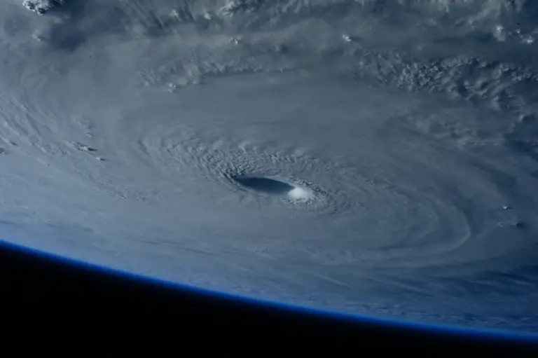
- Intensifying typhoons in the western Pacific.
- The Pacific Islands Forum advocates aggressive climate action globally.
Exploration and History
- Ferdinand Magellan crossed the Pacific (1520–21).
- James Cook charted extensive areas in the 18th century.
- The Challenger Expedition (1872–76) laid foundations of modern oceanography and first sounded the Challenger Deep.
- Thor Heyerdahl's Kon-Tiki expedition (1947) tested Polynesian migration theories.
UPSC Relevance
Prelims focus:
- Largest and deepest ocean; ~165 million sq km.
- Mariana Trench (Challenger Deep) – deepest point, ~11,000 m.
- Ring of Fire – earthquakes and volcanoes.
- Major currents: Kuroshio, California, Peru (Humboldt), East Australian.
- El Niño/La Niña/ENSO and impact on Indian monsoon.
- Island groups: Melanesia, Micronesia, Polynesia.
- Named by Magellan, 1520.
Mains GS angle (GS Paper I – Geography; GS Paper II – International Relations):
- Role of Pacific Ocean currents and ENSO in global climate and Indian monsoon.
- Indo-Pacific as a strategic construct and India's role in Quad.
- South China Sea disputes and implications for freedom of navigation.
- Climate-induced vulnerability of Pacific Island countries.
Sample PYQ angle: UPSC has asked on the Ring of Fire, El Niño impacts, and Indo-Pacific geopolitics. Expect questions linking currents to fisheries, ENSO to monsoon, and Quad to maritime security.
Tell Google you want more of this.
Add Anantam IAS as a preferred sourceOne tap, and this site shows up more often in your own Top Stories, AI Overviews and AI Mode. Remove it any time.