

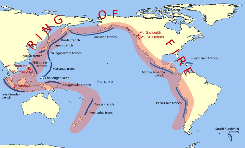
The Ring of Fire is a roughly horseshoe-shaped, 40,000-km-long belt that loops around the rim of the Pacific Ocean and concentrates the planet’s most active volcanoes and largest earthquakes. About 75% of the world’s active and dormant volcanoes — over 450 of them — and nearly 90% of global earthquakes, including most of the great megathrust events, occur in this belt. For UPSC physical geography (GS-I) and disaster management (GS-III), the Ring of Fire is the master example of how plate tectonics shapes hazard geography. India lies outside the Ring of Fire strictly defined, but its Andaman–Nicobar–Sumatra arc on the eastern flank shares the same subduction architecture.
What is the Ring of Fire?
The Ring of Fire — also called the circum-Pacific belt — is the chain of convergent and transform plate boundaries that encircle the Pacific Plate. It is not a single fault but a system of subduction zones and strike-slip margins where the Pacific, Nazca, Cocos, Juan de Fuca, Philippine and several smaller plates dive beneath or slide past adjacent continental and oceanic plates. The full geodynamic framework is set out in the plate tectonics theory.
Geographical extent
Starting from New Zealand and tracing the belt counter-clockwise, the Ring of Fire passes through:
- New Zealand’s North Island (Taupo Volcanic Zone)
- Tonga–Kermadec arc
- Mariana arc and trench
- Japan archipelago (Honshu, Hokkaido)
- Kamchatka Peninsula and the Kuril arc
- Aleutian Islands and Alaska
- Cascade Range of British Columbia, Washington and Oregon
- Sierra Madre and Trans-Mexican Volcanic Belt
- Central American arc (Guatemala to Panama)
- Andes mountain chain along South America
- Tierra del Fuego and the Scotia arc
- Looping back along Antarctica’s South Shetland Islands
A southwestern branch through the Philippines, Indonesia and the Andaman–Sumatra arc is usually included, even though some texts limit the Ring strictly to the Pacific rim.
Why the Ring of Fire Exists
The Ring of Fire is the surface signature of subduction. Most of the Pacific basin floor is oceanic lithosphere, denser and colder than adjacent continental crust. Where it meets surrounding plates, it bends and sinks back into the mantle along a subduction zone, generating two telltale signatures.
Volcanism
As the descending slab reaches a depth of about 100 km, water released from hydrated minerals lowers the melting temperature of the overlying mantle wedge. The resulting magma rises, often differentiating into silica-rich andesite and rhyolite, and erupts violently to form a chain of stratovolcanoes parallel to the trench. The full causal chain of seismic and volcanic energy release is covered in our note on earthquake causes and types.
Earthquakes
The slab itself slides downward in stick-slip motion against the overlying plate, generating large megathrust earthquakes on the shallow interface and a wedge of deeper events along the Wadati–Benioff zone. These are the engines of the great Pacific tsunamis covered in our tsunami causes and formation explainer.
Major Plates Involved
The Ring of Fire is built around interactions of the following plates:
- Pacific Plate — largest plate on Earth, subducting on its western and northern margins beneath the Philippine, Eurasian, North American and Aleutian arcs.
- Nazca Plate — subducting eastward beneath the South American Plate to form the Andes and the Peru–Chile trench.
- Cocos Plate — diving beneath Central America to produce the volcanoes of Guatemala, El Salvador, Nicaragua and Costa Rica.
- Juan de Fuca Plate — a small relic subducting beneath North America, generating the Cascade volcanoes.
- Philippine Sea Plate — subducting along the Mariana, Izu–Bonin and Ryukyu trenches.
- Australian Plate — colliding with the Pacific Plate to push up New Zealand’s Southern Alps.
Major Volcanoes Along the Ring of Fire
The belt has more than 450 volcanoes; the famous ones illustrate its diversity.
Japan
- Mount Fuji (3,776 m): the iconic stratovolcano of Honshu, last eruption 1707 (Hoei eruption).
- Sakurajima, Kyushu: one of the most active volcanoes in the world.
- Mount Aso: large caldera, frequent activity.
Indonesia and Philippines
- Krakatoa: 1883 eruption caused a tsunami that killed 36,000. Read about the wider tsunami context in our tsunami causes and formation note.
- Mount Tambora: 1815 VEI-7 eruption, the largest of recorded history, caused the “Year Without a Summer” (1816).
- Mount Merapi, Java: frequently active.
- Mayon Volcano, Philippines: near-perfect cone, almost continuously active.
- Mount Pinatubo: 1991 eruption cooled global climate by ~0.5°C for two years.
- Taal Volcano, Philippines: caldera lake with multiple recent eruptions.
Pacific North America
- Mount St Helens, Washington: 18 May 1980 lateral blast killed 57 and ejected 2.5 km³ of material.
- Mount Rainier and Mount Hood: stratovolcanoes of the Cascade Range.
- Mount Redoubt and Novarupta, Alaska: violent 20th-century activity. Novarupta’s 1912 eruption was the largest of the 20th century.
Central and South America
- Popocatépetl and Iztaccíhuatl, Mexico.
- Volcán de Fuego, Guatemala — devastating pyroclastic flow in 2018.
- Cotopaxi, Ecuador: world’s highest active volcano with permanent ice cap.
- Villarrica and Llaima, Chile.
- Nevado del Ruiz, Colombia: 1985 lahar destroyed Armero town, killing 25,000.
South Pacific
- Mount Ruapehu and Tongariro, New Zealand.
- Yasur, Vanuatu: continuously erupting for centuries.
Major Earthquakes Along the Ring of Fire
The Ring has produced almost every great earthquake of modern times:
- Valdivia, Chile (1960): M 9.5 — largest instrumentally recorded earthquake; Pacific-wide tsunami.
- Alaska (1964): M 9.2 — second-largest; Anchorage devastation.
- Sumatra–Andaman (2004): M 9.1–9.3 — triggered the Indian Ocean tsunami 2004 that killed ~227,898.
- Tohoku, Japan (2011): M 9.1 — caused the Fukushima Daiichi nuclear accident.
- Kamchatka (1952): M 9.0.
- Maule, Chile (2010): M 8.8.
- San Francisco (1906): M 7.9 — on the San Andreas transform fault.
Trenches of the Ring of Fire
Deep-sea trenches mark where one plate dives under another:
- Mariana Trench — deepest at 10,994 m (Challenger Deep).
- Tonga Trench — 10,882 m.
- Kuril–Kamchatka Trench — 10,542 m.
- Philippine Trench — 10,540 m.
- Japan Trench — 8,412 m.
- Aleutian Trench — 7,679 m.
- Peru–Chile (Atacama) Trench — 8,065 m.
- Middle America Trench — 6,669 m.
Each is paired with a parallel volcanic arc, illustrating the symmetry of subduction geography.
India and the Ring of Fire
Peninsular India and the Indo-Gangetic plain lie outside the Ring of Fire. India’s seismicity is dominated by the Alpine–Himalayan belt to the north, where the Indo-Australian Plate collides with Eurasia. There are no active volcanoes on mainland India.
However, India’s island territories sit at the gateway of the Ring of Fire’s south-western arm.
Andaman and Nicobar arc
The Andaman–Sumatra subduction zone, where the Indo-Australian Plate dives beneath the Burmese and Sunda micro-plates, is a continuation of the same architecture that produces the Ring of Fire’s classic volcanism and tsunamigenic earthquakes.
- Barren Island: India’s only confirmed active volcano, in the Andaman Sea. It has erupted repeatedly since 1991.
- Narcondam Island: dormant volcano of the same arc.
- The arc generated the catastrophic 2004 megathrust earthquake and tsunami.
The Andaman–Sumatra arc thus links India operationally to the Ring of Fire through tsunami hazard, even though the mainland is geographically separate.
Significance for UPSC
The Ring of Fire is repeatedly tested for the following reasons:
- It illustrates plate tectonics at work — convergence, subduction, volcanic arc formation, deep-sea trenches.
- It explains the global distribution of earthquakes, volcanoes and tsunamis — the three coupled hazards.
- It provides ready case studies for disaster management under NDMA’s hazard framework.
- It shapes trade and economy through earthquake risk to Japan, the US west coast and ASEAN supply chains.
- It links to climate science through volcanic forcing — Pinatubo 1991 and Tambora 1815 caused measurable global cooling.
Frequently Asked Questions
What is the Ring of Fire?
The Ring of Fire is a roughly 40,000-km-long horseshoe belt of subduction zones, volcanoes and earthquake epicentres around the Pacific Ocean’s rim. It hosts about 75% of the world’s volcanoes and 90% of its earthquakes.
Why is it called the Ring of Fire?
The name comes from the chain of active volcanoes — the u0022fireu0022 — that traces an almost continuous ring along the Pacific margin from New Zealand, through Japan and Alaska, down the Americas to southern Chile.
Which plates form the Ring of Fire?
The belt is built by interactions of the Pacific Plate with the Australian, Philippine, Eurasian, North American, Juan de Fuca, Cocos and Nazca plates, mostly along convergent (subduction) and transform boundaries.
Why does the Ring of Fire have so many volcanoes?
Wherever oceanic lithosphere subducts to ~100 km depth, water released from the slab lowers the melting point of the overlying mantle. The magma rises to form chains of stratovolcanoes parallel to the trenches — almost the entire Pacific rim has this configuration.
Is India part of the Ring of Fire?
Mainland India lies outside the Ring of Fire. Its seismicity belongs to the Alpine–Himalayan belt. But the Andaman & Nicobar Islands sit on the south-western arm of the belt, and Barren Island in the Andaman Sea is India’s only active volcano.
What is the most active volcano in the Ring of Fire?
Indonesia’s Mount Merapi, Italy is not in the Ring, but Japan’s Sakurajima, Mexico’s Popocatépetl, Guatemala’s Fuego and Hawaii’s Kilauea (hotspot, technically not subduction) are among the most continuously active volcanoes within or near the belt.
How is the Ring of Fire linked to tsunamis?
Most major tsunamis are generated by megathrust earthquakes along the Ring of Fire’s subduction zones — Chile 1960, Alaska 1964, Sumatra 2004 and Japan 2011 are all Ring of Fire events.
What is the difference between the Ring of Fire and the Alpine–Himalayan belt?
The Ring of Fire is the circum-Pacific belt of subduction-driven volcanism and seismicity. The Alpine–Himalayan belt runs from the Mediterranean through Iran and the Himalayas to Indonesia, dominated by continental collision (the Himalayas) and far fewer active volcanoes. Together they account for almost all global seismicity.
Tell Google you want more of this.
Add Anantam IAS as a preferred sourceOne tap, and this site shows up more often in your own Top Stories, AI Overviews and AI Mode. Remove it any time.






