Disclosure: this guide contains Amazon affiliate links. As an Amazon Associate, Anantam IAS earns from qualifying purchases — at no extra cost to you.
The Brahmaputra is one of the world's great rivers — a trans-boundary river that flows through Tibet (China), India, and Bangladesh before emptying into the Bay of Bengal. Known by different names in each region it traverses, the Brahmaputra is unique among major Indian rivers for being a male river in Indian tradition (most Indian rivers are considered female). With a total length of approximately 2,900 km, a drainage basin of over 580,000 sq km, and an average discharge that ranks it among the top ten rivers globally, the Brahmaputra shapes the geography, economy, and geopolitics of the entire eastern Himalayan region.
For UPSC, the Brahmaputra is critical in Geography (GS1) for river systems, flood management, and trans-boundary water disputes, and in International Relations (GS2) for India-China water diplomacy.
The River's Many Names
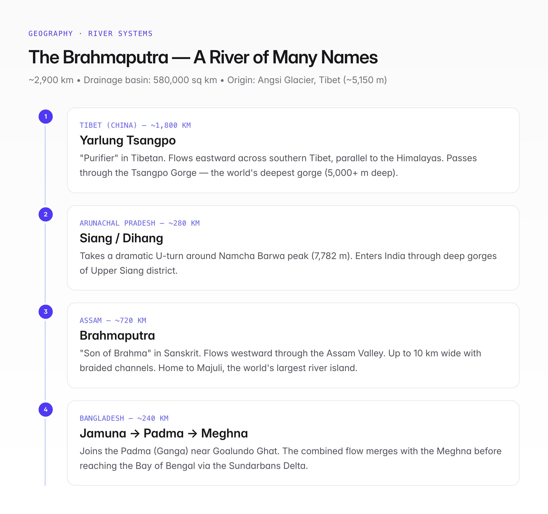
One of the most distinctive features of the Brahmaputra is that it changes its name as it crosses political and geographic boundaries:
| Region | Name | Meaning/Origin |
|---|---|---|
| Tibet (China) | Yarlung Tsangpo | "Purifier" in Tibetan |
| Arunachal Pradesh (entry into India) | Siang or Dihang | Local Adi tribal name |
| Assam (main course in India) | Brahmaputra | "Son of Brahma" in Sanskrit |
| Bangladesh | Jamuna | Not to be confused with the Yamuna in North India |
| After joining Padma (Ganga) | Padma, then Meghna | Before reaching the Bay of Bengal |
Course of the Brahmaputra

Oxford Student Atlas for India — 7th Edition
- 160 pages, Oxford University Press, the current edition
- India-focused thematic maps: physical, political, rivers, climate, soils, vegetation, plus world maps
- Made for UPSC and state PSC map work; slim enough to stay open beside the textbook
Origin and Tibet Section (~1,800 km)
- Origin: Angsi Glacier near Chemayungdung in the Kailash Range of southern Tibet, at an elevation of about 5,150 metres
- Flows eastward across the entire length of southern Tibet as the Yarlung Tsangpo, running parallel to the Himalayas
- Passes through the Tsangpo Gorge (also called Yarlung Tsangpo Grand Canyon) — the deepest gorge in the world (over 5,000 m deep), deeper than the Grand Canyon
- Takes a dramatic U-turn around Namcha Barwa peak (7,782 m) before entering India
Arunachal Pradesh Section (~280 km)
- Enters India in the Upper Siang district of Arunachal Pradesh as the Siang (also called Dihang)
- Flows through deep gorges and forested valleys
- Receives the Dibang and Lohit rivers near Sadiya in eastern Assam
- After this confluence, the river becomes the Brahmaputra
Assam Section (~720 km)
- Flows westward through the Assam Valley (one of the few major rivers in the world that flows westward for a significant stretch)
- The valley is bounded by the Himalayas and Meghalaya Plateau to the north and south
- Braided river system: The Brahmaputra in Assam is extremely wide (up to 10 km in places) with multiple channels, sandbars, and river islands
- Home to Majuli, the world's largest river island
- Receives numerous tributaries from both north (Himalayan) and south (Meghalaya Plateau) banks
Bangladesh Section (~240 km)
- Enters Bangladesh near Kurigram and is renamed the Jamuna
- Joins the Padma (Ganga) near Goalundo Ghat
- The combined flow (Padma) then merges with the Meghna before reaching the Bay of Bengal
- Forms part of the Sundarbans Delta — the world's largest delta
Major Tributaries
North Bank (Himalayan) Tributaries
| Tributary | Origin | Key Feature |
|---|---|---|
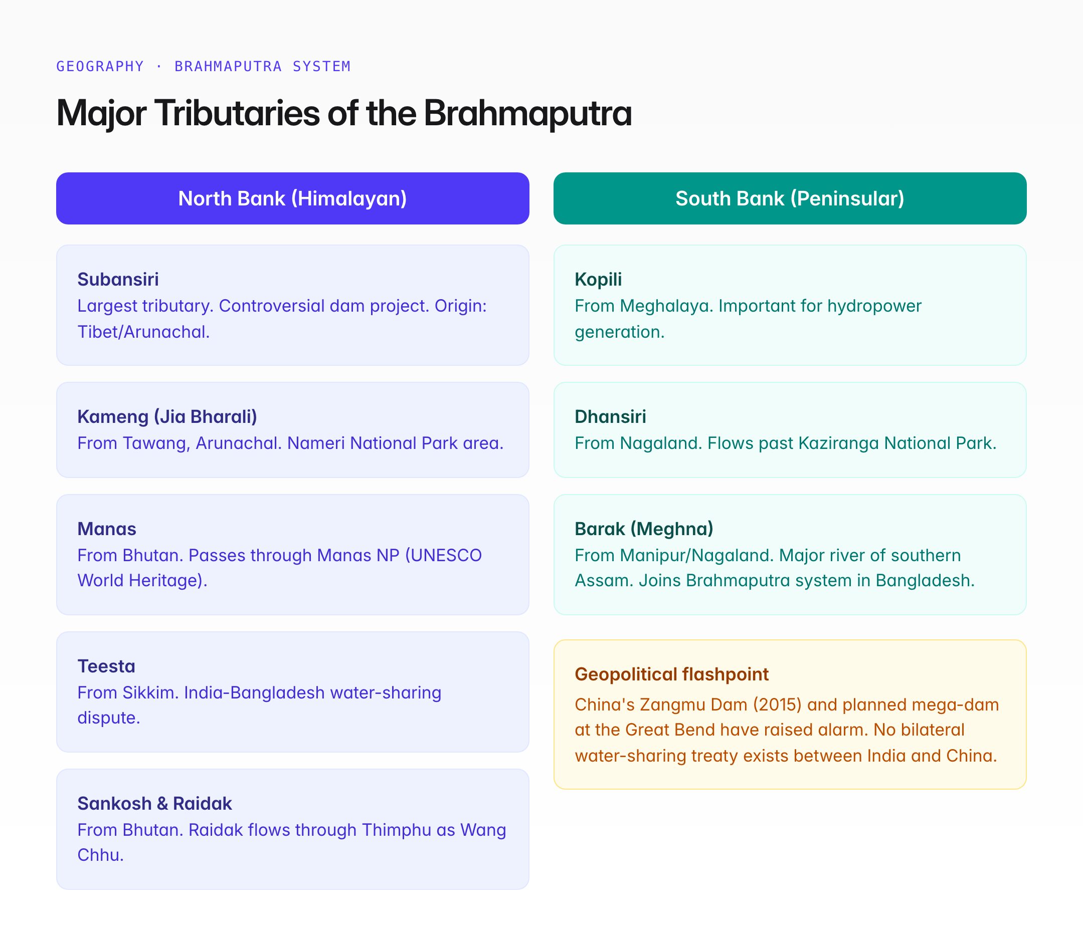
| Subansiri | Tibet/Arunachal | Largest tributary of the Brahmaputra; site of a controversial dam project |
| Kameng (Jia Bharali) | Arunachal (Tawang) | Important for Nameri National Park area |
| Manas | Bhutan/Assam | Passes through Manas National Park (UNESCO World Heritage Site) |
| Sankosh | Bhutan | Forms part of the Assam-West Bengal border |
| Teesta | Sikkim | Joins the Brahmaputra in Bangladesh; subject of India-Bangladesh water-sharing dispute |
| Raidak (Wang Chhu) | Bhutan | Flows through Bhutan's capital Thimphu before entering India |
South Bank (Peninsular/Meghalaya Plateau) Tributaries
| Tributary | Origin | Key Feature |
|---|---|---|
| Kopili | Meghalaya | Important for hydropower |
| Dhansiri | Nagaland | Flows past Kaziranga National Park |
| Barak (Meghna) | Manipur/Nagaland | Major river of southern Assam; joins Brahmaputra system in Bangladesh |
Majuli — The World's Largest River Island
Majuli is a river island in the Brahmaputra in Jorhat district, Assam, and holds special significance:
- Area: ~352 sq km (though shrinking due to erosion; was ~880 sq km in 1901)
- Declared a district in 2016 — India's first island district
- Home to Vaishnavite Satras (monasteries) established by Srimanta Sankardeva in the 15th-16th century
- Cultural centre of Assamese Neo-Vaishnavism
- Nominated for UNESCO World Heritage Site status
- Faces severe threat from riverbank erosion — losing an estimated 2-3 sq km per year
Floods — The Brahmaputra's Destructive Power
The Brahmaputra is one of the most flood-prone rivers in the world:
- Annual flooding in Assam displaces millions of people and destroys crops, infrastructure, and wildlife
- Causes: Heavy monsoon rainfall, snowmelt from Himalayas, steep gradient of tributaries, deforestation, high sediment load, braided channel pattern
- Sediment load: Among the highest of any river globally (~735 million tonnes/year), causing the river to constantly shift course
- Kaziranga National Park experiences annual floods that are both destructive and ecologically essential (floods maintain the park's grassland ecosystem)
- The Brahmaputra Board (established 1980) is tasked with flood management and river valley planning
China's Dam Concerns
The fact that the Brahmaputra originates in Chinese-controlled Tibet creates significant geopolitical tensions:
- China has built the Zangmu Dam (2015) and several other hydropower projects on the Yarlung Tsangpo
- India fears that Chinese dams could alter water flows, reduce downstream availability, or be used as a strategic tool during conflicts
- China's plan for a mega-dam at the Great Bend of the Tsangpo (near the Namcha Barwa turn) — potentially the world's largest hydropower project — has raised alarm in India and Bangladesh
- There is no bilateral water-sharing treaty between India and China on the Brahmaputra; only a hydrological data-sharing agreement exists
- India has accelerated its own dam-building on tributaries (e.g., Subansiri Lower Dam, Upper Siang Multipurpose Project) partly as a counter-strategy
UPSC Relevance
GS Paper I: Geography — River systems of India, drainage patterns, flood management, river islands, trans-boundary rivers.
GS Paper II: International Relations — India-China water diplomacy, India-Bangladesh water sharing (Teesta), trans-boundary river governance.
GS Paper III: Disaster management — Floods in Assam, climate change impact on Himalayan river systems.
Key Points for Prelims
- The Brahmaputra is known as Yarlung Tsangpo in Tibet, Siang/Dihang in Arunachal Pradesh, Brahmaputra in Assam, and Jamuna in Bangladesh
- Originates near the Angsi Glacier in Tibet at ~5,150 m elevation
- Flows through the Tsangpo Gorge — the world's deepest gorge
- Flows eastward in Tibet, then takes a U-turn around Namcha Barwa before entering India
- In Assam, it flows westward — unusual for a major Himalayan river
- Majuli is the world's largest river island (Jorhat, Assam)
- Subansiri is the largest tributary of the Brahmaputra
- Teesta is a tributary subject to India-Bangladesh water-sharing disputes
- China's Zangmu Dam on the Tsangpo is a key geopolitical concern
- Total length: ~2,900 km; drainage basin: ~580,000 sq km
Tell Google you want more of this.
Add Anantam IAS as a preferred sourceOne tap, and this site shows up more often in your own Top Stories, AI Overviews and AI Mode. Remove it any time.