

A cloudburst is one of those weather events that arrives without warning and leaves a long trail of destruction. In a few minutes, a small high-altitude cloud cell can dump tens of millimetres of rain over a square kilometre, triggering flash floods, landslides, and debris flows that surge down narrow Himalayan valleys faster than any siren can sound. India’s experience with cloudbursts has been concentrated in the Himalayan and Western Ghats catchments, but the climate signature is intensifying, and the impact zones are widening.
The 2025 inauguration of C-FLOOD, the Unified Inundation Forecasting System, by the Union Minister of Jal Shakti, marks a major institutional response. C-FLOOD aims to provide two-day advance flood inundation forecasts at the village level for Indian river basins, integrating outputs from the Central Water Commission, C-DAC, and the Department of Water Resources, River Development and Ganga Rejuvenation. It is built under the National Supercomputing Mission and uses two-dimensional hydrodynamic modelling that goes beyond simple river-stage forecasts to map the actual spread of floodwaters across floodplains.
For UPSC, cloudbursts and flood forecasting are core GS-III topics. They tie together meteorology, climate change, disaster management, river-basin governance, and infrastructure resilience. This guide walks through what cloudbursts are, why they happen, what C-FLOOD does, why it matters for early warning, and how India can prepare better for the next decade of intensifying flood risk.
Quick Facts
- C-FLOOD launched: 2025 by the Union Minister of Jal Shakti
- Lead agency: Central Water Commission (CWC)
- Co-developer: Centre for Development of Advanced Computing (C-DAC)
- Parent ministry: Ministry of Jal Shakti, Department of Water Resources, RD and GR
- Scientific framework: National Supercomputing Mission
- Forecasting capability: Two-day advance inundation forecasts up to village level
- Modelling approach: Two-dimensional hydrodynamic simulation
- Initial river basins covered: Godavari, Mahanadi, Tapi
- IMD definition of cloudburst: Rainfall greater than 100 mm in one hour over an area of about 20-30 square kilometres
- Most affected regions: Himalayan states (Himachal Pradesh, Uttarakhand, Jammu and Kashmir, Sikkim, Arunachal Pradesh), Western Ghats
- Common physical mechanism: Orographic uplift of moisture-laden air against steep terrain
- Notable recent events: Kedarnath 2013, Leh 2010, Amarnath 2022, Wayanad 2024, multiple Himachal events 2023-25
- National flood forecast nodes: CWC operates 332 flood-forecast stations across India
What Is a Cloudburst
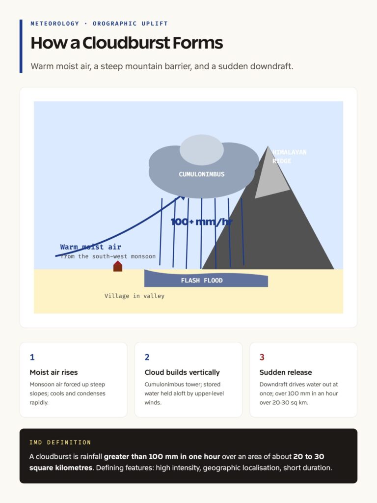
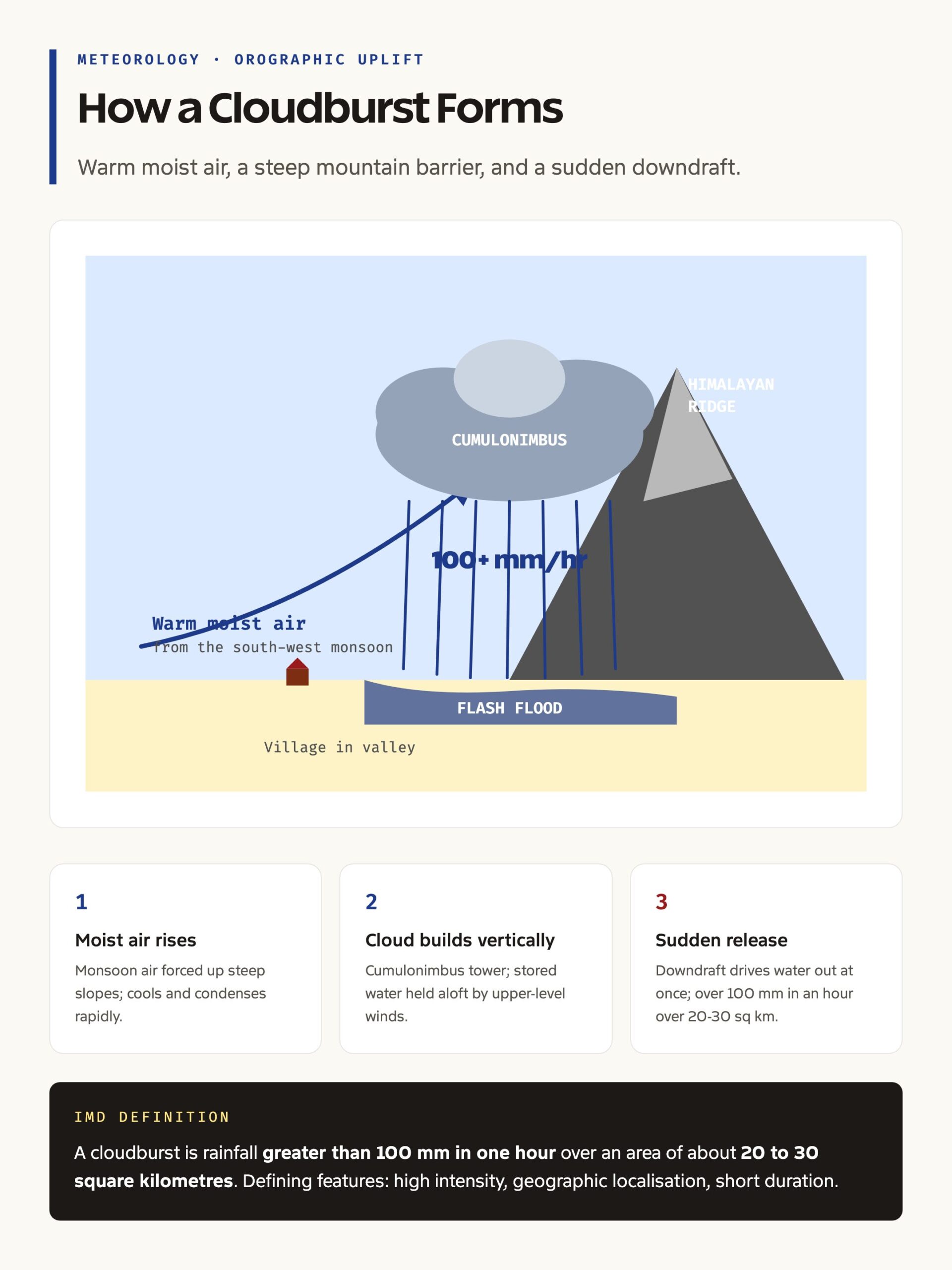
A cloudburst is an extreme rainfall event in which a small geographical area receives an exceptionally large volume of rain over a very short time. The Indian Meteorological Department defines it operationally as rainfall greater than 100 mm per hour over a roughly 20 to 30 square kilometre area. The defining features are intensity, localisation, and brevity. A cloudburst is not a long monsoon spell. It is a sudden, localised, high-intensity downpour.
The physical mechanism behind most Indian cloudbursts is straightforward. Warm, moisture-laden air rises rapidly when forced over a mountain barrier, a process known as orographic uplift. As the air ascends, it cools, the moisture condenses, and a cumulonimbus cloud builds vertically. If the rising air remains trapped beneath strong upper-level winds or if a downdraft of dry air drives the cloud’s stored water out at once, the result is a sudden release of an enormous volume of rain. In Himalayan valleys, the steep terrain channels the runoff into narrow streams, multiplying the destructive potential.
The hydrological consequence is a flash flood. Soil cannot absorb the rain at the rate of fall. Streams and small rivers swell within minutes. Slopes saturate and slip. Debris, boulders, trees, and structures move downstream as a slurry that has the kinetic energy of a slow landslide combined with the speed of a torrent. Lives, livestock, vehicles, and infrastructure in the path of this surge have very little time to escape.
Background and Historical Context
Cloudbursts are not a new phenomenon in the Indian Himalayas. Mountain communities have lived with sudden rainfall events for centuries, building stone retaining walls, terrace farming, and settlement patterns that account for periodic flash floods. What has changed in recent decades is the frequency and intensity of these events, the scale of human exposure, and the institutional capacity to forecast them.
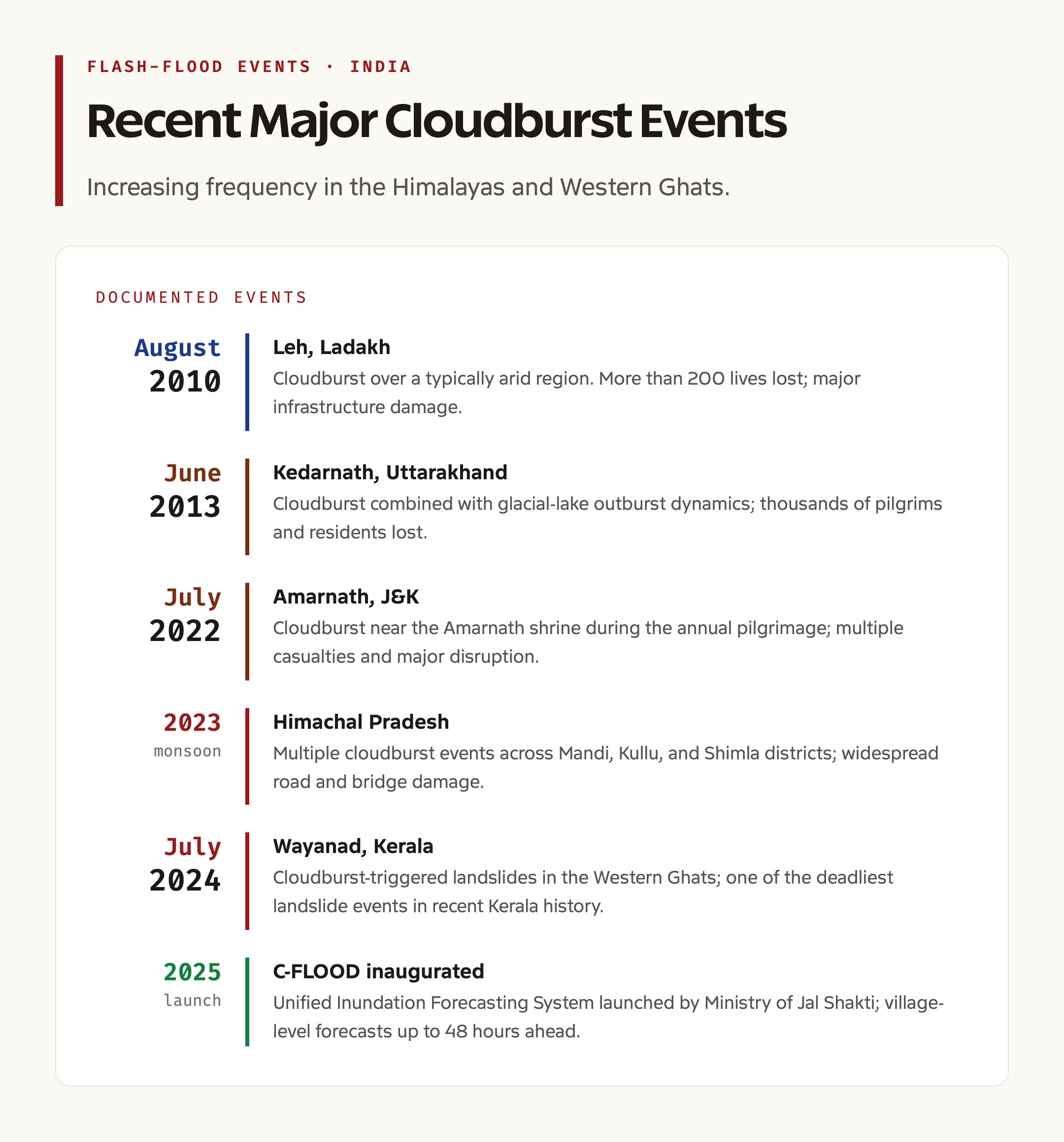
The Leh cloudburst of August 2010 was a turning point. A high-intensity rainfall event over Ladakh’s typically dry terrain killed more than 200 people and damaged infrastructure across Leh town. The Kedarnath disaster of June 2013 was even more devastating, with cloudburst-triggered flooding combined with glacial-lake outburst dynamics killing thousands of pilgrims and residents. The Amarnath cloudburst of 2022, the Himachal floods of 2023, and the Wayanad landslides of 2024 have continued the pattern.
The institutional response evolved through this period. The India Meteorological Department upgraded its Doppler radar network and improved short-range forecasting. The Central Water Commission expanded flood-forecast stations from a few dozen in the 1990s to more than 330 by 2024. The National Disaster Management Authority developed mountain-specific flood and landslide protocols. Despite these advances, the lead time on cloudburst forecasts remained short, often only minutes to hours, making evacuation difficult.
C-FLOOD represents the next institutional leap. By integrating high-resolution rainfall forecasts, basin hydrology, and two-dimensional inundation modelling at village scale, it aims to convert short lead-time information into actionable two-day forecasts. The supercomputing platform allows the simulation of inundation patterns that earlier one-dimensional models could not produce.
Key Provisions of the C-FLOOD System
Two-day advance inundation forecast
C-FLOOD generates flood inundation forecasts up to 48 hours in advance. The two-day window is significant because it crosses the threshold required for meaningful evacuation, supply pre-positioning, and infrastructure protection actions.
Village-level resolution
Unlike traditional flood forecasts that report water levels at gauging stations, C-FLOOD produces inundation maps that show which villages, agricultural blocks, and roads will be submerged. This resolution is essential for last-mile decision-making.
Two-dimensional hydrodynamic modelling
The core science is 2-D hydrodynamic simulation. The model solves the shallow water equations across a digital elevation grid, capturing how water spreads laterally on floodplains rather than only how it moves down the channel. This is far more realistic for flat alluvial geographies and for backwater effects in tributaries.
Unified national platform
C-FLOOD integrates flood-modelling outputs from CWC, IIT institutions, state water resources departments, and other agencies into a single web-based platform. The integration reduces information fragmentation and avoids the situation where different agencies issue conflicting forecasts.
Initial coverage
The first phase covers the Godavari, Mahanadi, and Tapi river basins. These represent peninsular alluvial systems with significant flood-prone agricultural and urban populations. Future phases are expected to extend to the Brahmaputra, Ganga, and other major basins.
National Supercomputing Mission backbone
C-FLOOD runs on supercomputing infrastructure built under the National Supercomputing Mission, a joint initiative of the Department of Science and Technology and MeitY. The computational requirements of high-resolution 2-D modelling are met through this national platform.
Why It Matters
Cloudburst flooding matters because it is one of the most lethal forms of disaster in India per unit of warning time. Earthquakes and cyclones often allow at least a few hours of preparation. Cloudbursts can compress that to minutes. Improved forecast lead time, even if only to two days at basin scale, transforms the response options available to district administrations.
The 2025 launch of C-FLOOD signals India’s commitment to integrated flood-risk management. Rather than relying solely on river-stage gauges, the country is moving to floodplain-scale inundation forecasting that supports village-level decisions. This is in line with World Meteorological Organization recommendations and with practice in flood-prone European, North American, and East Asian basins.
The climate change angle adds urgency. The Indian Himalayan region is warming faster than the global average. Atmospheric moisture content is rising. Cloudburst frequency in some Himalayan basins has increased measurably over the past two decades, as documented in IMD reports and peer-reviewed analyses. The risk envelope is expanding both up the elevation gradient (events at higher altitudes than before) and across new geographies (cloudburst-style events in non-traditional zones).
The economic stake is substantial. Tourism, hydropower, agriculture, and road infrastructure in mountain states depend on predictable hydrological behaviour. Flash floods damage hydropower intakes, disrupt highway networks like the Mandi-Manali corridor, and erode floodplain agriculture. Insurance penetration is low, so most losses are absorbed directly by households and the state budget.
Detailed Analysis
A closer technical look reveals both the strengths and the limits of the C-FLOOD framework. The 2-D hydrodynamic core is internationally proven. Software such as MIKE 21, HEC-RAS 2D, and TUFLOW have been used for decades in the United States, Europe, and Australia for floodplain mapping. Adapting the approach to Indian basins requires accurate digital elevation models, calibrated channel geometries, validated rainfall-runoff relationships, and reliable observational data for model verification.
India’s data foundation has improved but remains uneven. The CWC operates 332 flood-forecast stations and 700-plus level stations. ISRO’s CartoDEM and Bhuvan platforms provide digital elevation data at 30-metre resolution, with higher-resolution data for select areas. IMD’s Doppler radar network now spans much of the country, though Himalayan terrain still has coverage gaps.
The forecast chain works as follows. IMD’s numerical weather prediction models generate quantitative precipitation forecasts. These feed into rainfall-runoff hydrological models that calculate basin discharge. Discharge feeds into the 2-D hydrodynamic model, which maps inundation. The output is communicated to state disaster management authorities and district administrations through dedicated platforms.
Limits remain. Cloudbursts are sub-grid events for most NWP models. Even 12-kilometre resolution models smooth out the localised intensity of a true cloudburst. Specialised convective-scale models with kilometre-scale resolution are needed, and these are computationally expensive. Two-day lead time is therefore meaningful for monsoon-fed flooding but may still be limited for the most intense localised cloudburst events.
The institutional layer is also critical. A perfect forecast is useless if district administrations cannot act on it. Standard operating procedures, evacuation routes, communication chains, and pre-positioned relief materials must work in tandem with the forecast system. The Disaster Management Act framework in India provides the legal architecture, but local-level capacity varies widely.
Comparative Perspective
International comparison helps situate C-FLOOD. The European Flood Awareness System runs at continent scale with member-state integration. The United States National Water Model produces high-resolution streamflow forecasts integrated with the National Weather Service warning system. Japan’s River Bureau operates highly automated flood-monitoring networks for typhoon-driven events. China’s national flood-forecast system manages the Yangtze and Yellow basins through real-time data assimilation.
C-FLOOD shares the design DNA of these systems but starts with the constraint of greater hydrological diversity, denser populations on floodplains, and a more compressed budget for sensors and computation. The early peninsular focus on Godavari, Mahanadi, and Tapi is sensible because these basins have established gauging networks and large flood-prone agricultural populations.
The challenge for India will be extending the model to Himalayan basins where cloudbursts are most lethal. Mountain terrain demands finer DEM resolution, denser rain gauges, and convective-scale weather prediction. The Brahmaputra basin adds the complication of trans-boundary flow from China.
Challenges
Three sets of challenges face India’s flood-forecast modernisation. First, the data and computation gap remains real for cloudburst forecasting at meaningful lead times. Two-day basin-scale forecasts are useful, but minute-scale localised cloudburst alerts require Doppler radar saturation and kilometre-scale convective models that are still being deployed.
Second, the institutional translation gap is the difference between a forecast and an action. State disaster management authorities, district administrations, panchayats, and last-mile communication networks must translate forecast probabilities into concrete protective actions. Capacity for this translation is uneven across states.
Third, infrastructure compounds risk. Unplanned construction on Himalayan slopes, river-channel encroachment, hydropower-project siting, road construction debris, and quarrying all reduce the resilience of mountain catchments. A perfect forecast cannot offset systematic risk amplification through poor land-use planning.
Prelims Pointers
- C-FLOOD was inaugurated in 2025 by the Union Minister of Jal Shakti
- It is a Unified Inundation Forecasting System
- Lead agency is the Central Water Commission (CWC)
- Co-developed with C-DAC and DoWR, RD and GR
- Built under the National Supercomputing Mission
- Uses two-dimensional hydrodynamic modelling
- Initial coverage: Godavari, Mahanadi, and Tapi basins
- Provides two-day advance inundation forecasts at village level
- IMD defines a cloudburst as rainfall greater than 100 mm per hour over a 20-30 square kilometre area
- Cloudbursts are most common in Himalayan states and the Western Ghats
- Common physical cause is orographic uplift
- Floods can deposit nutrient-rich alluvium and increase soil fertility
- Floods can also disperse invasive plants such as water hyacinth, increase turbidity, and cause eutrophication
Mains Practice Questions
- Discuss the meteorological causes of cloudbursts in the Indian Himalayas. Examine the institutional response through C-FLOOD and other mechanisms, and suggest measures for reducing flash-flood risk.
- Critically evaluate the C-FLOOD system as a model for unified flood forecasting. What are its strengths, its limits, and the steps needed to extend it to Himalayan and Northeast basins?
- The ecological impact of floods is a mixed picture. Discuss with examples how floods can both rejuvenate ecosystems and degrade them, drawing on Indian river systems.
- India’s exposure to climate-driven extreme rainfall is rising. Connecting the topic to broader cyclones and flood patterns in India, suggest a national framework for compound hydrological risk management.
Way Forward
Several priorities emerge for the next phase of cloudburst and flood resilience. First, extend C-FLOOD coverage rapidly to Himalayan and Northeast basins. Brahmaputra, Indus tributaries, Sutlej, Beas, Ravi, Teesta, Subansiri, and Lohit are all priorities. The technical challenge is denser rain-gauge networks, finer DEMs, and convective-scale weather models tuned to mountain meteorology.
Second, integrate flood forecasting with state-level disaster management standard operating procedures. Forecast information must reach panchayats, schools, hospitals, hydropower operators, and tourist hubs in formats they can act on within minutes.
Third, link land-use planning to flood-risk maps. C-FLOOD outputs should feed into building approvals, road alignment decisions, hydropower-project clearances, and tourism-infrastructure permits. Development on demonstrated inundation zones should be restricted.
Fourth, scale community-level preparedness. Mock drills, evacuation route signage, multilingual mobile alerts, and trained local volunteers reduce loss of life when forecasts have short lead times. The NDMA framework provides the templates.
Fifth, invest in scientific capacity. Convective-scale numerical weather prediction, Doppler radar gap-filling in mountain terrain, snowmelt-runoff modelling, and glacial-lake monitoring are all critical investments. Partnerships with IIT institutions, ISRO, IISc, and international agencies should be expanded.
For UPSC aspirants, the broader lesson is that flood forecasting is not just hydrology. It is meteorology plus hydrology plus computational modelling plus governance plus communication. C-FLOOD ties these together for the first time at national scale.
Frequently Asked Questions
What is a cloudburst as defined by IMD?
The India Meteorological Department defines a cloudburst as rainfall greater than 100 millimetres per hour over a roughly 20 to 30 square kilometre area. The defining features are high intensity, geographic localisation, and short duration.
What is the C-FLOOD system?
C-FLOOD is the Unified Inundation Forecasting System launched in 2025 by the Ministry of Jal Shakti. It is led by the Central Water Commission, co-developed with C-DAC, and runs under the National Supercomputing Mission. The system provides two-day advance flood-inundation forecasts at village level using two-dimensional hydrodynamic modelling.
Which river basins does C-FLOOD initially cover?
The initial phase covers the Godavari, Mahanadi, and Tapi basins. Future phases are expected to extend to the Brahmaputra, Ganga, Indus tributaries, and other major systems.
What is two-dimensional hydrodynamic modelling?
2-D hydrodynamic modelling solves the shallow water equations across a digital elevation grid to simulate how floodwater spreads laterally across floodplains. It captures backwater effects, urban inundation patterns, and floodplain dynamics that traditional one-dimensional channel models miss.
Why are Himalayan states most affected by cloudbursts?
Himalayan states have steep terrain that forces orographic uplift of monsoon air, narrow valleys that channel runoff, fragile slopes that produce landslides, and dense settlement patterns along streams. The combination amplifies the impact of any localised intense rainfall.
Are cloudbursts becoming more frequent in India?
IMD records and peer-reviewed analyses indicate that the frequency and intensity of cloudburst-style extreme rainfall events have increased in parts of the Himalayas and Western Ghats over the past two decades. The trend is consistent with climate-driven increases in atmospheric moisture content.
What is the difference between a flood and a flash flood?
A flood is a general inundation event that can develop over hours, days, or weeks as river basins fill. A flash flood is a sudden, short-duration flood with very rapid onset, usually caused by intense localised rainfall such as a cloudburst, a dam-break event, or a glacial-lake outburst.
How does the IMD warning system work for heavy rain?
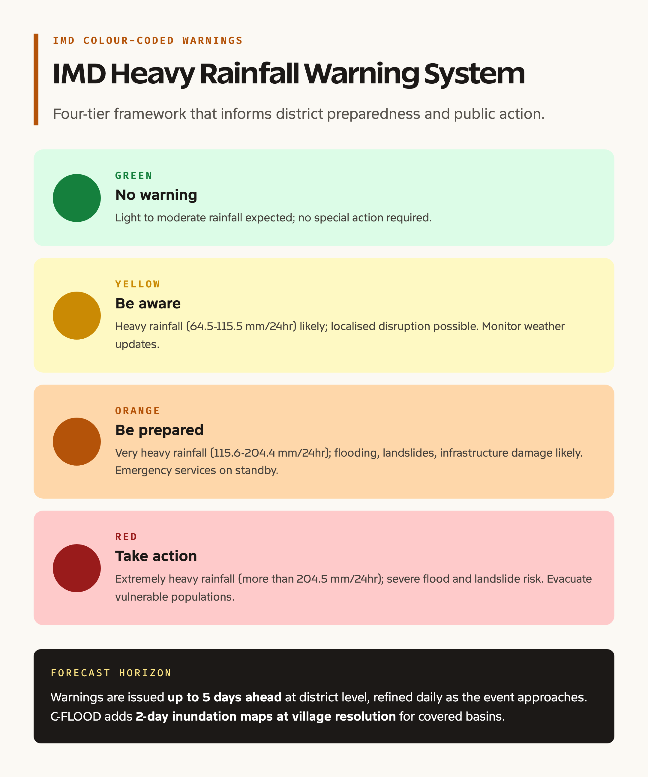
IMD uses a colour-coded warning framework: green (no action), yellow (be aware), orange (be prepared), and red (take action). Warnings are issued at the district level for forecasts up to five days, with more frequent updates as the event approaches.
Do floods have any positive ecological effects?
Yes. Floods deposit nutrient-rich alluvium that enhances soil fertility, recharge floodplain aquifers, disperse seeds of native species, and flush out invasive plants such as water hyacinth in some cases. The agricultural productivity of Indo-Gangetic floodplains depends partly on this annual rejuvenation.
What are the negative ecological effects of large floods?
Excessive turbidity reduces photosynthesis in aquatic plants, eutrophication occurs from washed-off fertilisers and pesticides, bioaccumulation of pollutants moves up food chains, saline intrusion damages freshwater bodies and soils, and physical destruction can reset ecosystems for years.
Tell Google you want more of this.
Add Anantam IAS as a preferred sourceOne tap, and this site shows up more often in your own Top Stories, AI Overviews and AI Mode. Remove it any time.






