Why in News?
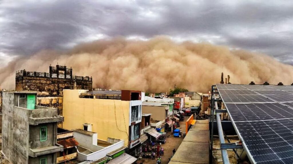
A massive dust storm swept through Churu, Hanumangarh, Sri Ganganagar, Bikaner, Nagaur, Alwar, and Sikar in Rajasthan, generating viral imagery of an “apocalyptic” wall of sand.
Meteorologists flagged the event as evidence of the Aravalli range’s declining capacity to intercept and filter dust-laden winds from the Thar Desert before they reach the densely populated Indo-Gangetic plains. The trend has been worsening for decades due to unchecked mining and deforestation across the range’s 700-km extent.
| UPSC Relevance: GS-3 Environment and Biodiversity: Conservation Prelims & Mains: Aravalli Range: Importance, Degradation and Govt. Policies |
The Aravallis are among the oldest fold mountain systems in the world, formed approximately 1.5-2 billion years ago through repeated tectonic plate collisions. They extend approximately 692-700 km in a northeast-southwest orientation from Delhi through Haryana and Rajasthan to Gujarat, reaching a maximum height of 1,722 m at Guru Shikhar, Mount Abu.
Why are the Aravallis Important?
1. Natural Barrier against Desertification:
- The Aravallis act as a geographical wall that slows down hot westerly winds carrying sand from the Thar Desert. When these winds encounter the hills:
- Wind velocity decreases.
- Sand particles settle on the slopes.
- Dust transport towards northern India is reduced.
- Large deposits of obstacle dunes on western slopes provide physical evidence of this role. Without the Aravallis, desertification could advance eastward towards Delhi NCR, Haryana, Western Uttar Pradesh and Punjab.
- Vegetation on these dunes creates a further natural scrubbing effect, dispersing wind energy and trapping fine particles before they can cross into the plains.
2. Air Quality Regulation:
- The hills and associated vegetation perform a natural scrubbing function, dispersing wind energy and trapping fine particles before they can cross into the plains. This function is especially important for Delhi-NCR, which already faces severe PM2.5 and PM10 pollution.
3. Hydrological lifeline:
- The Aravalli Range acts as a major continental watershed. The Chambal and Banas rivers originate on their eastern slopes and eventually drain into the Yamuna-Ganga system. The Luni and Sabarmati originate on their western slopes and drain into the Arabian Sea
- The fractured quartzites and ridges act as a giant subterranean sponge that facilitates rapid rainwater percolation. The Aravallis remain the primary ecological buffer and natural groundwater recharger for the National Capital Region (NCR).
4. Influence Local Precipitation:
- The Aravallis act as an effective physical barrier for the Bay of Bengal branch of the monsoon. They force those winds to rise, causing precipitation on the eastern side of the range and throughout the wider northwestern plains (including Delhi and Haryana).
5. Biodiversity and Wildlife:
- The Aravallis host 22 protected areas, including Ranthambore, Sariska, and Ramgarh Vishdhari Tiger Reserves (Rajasthan) and Asola Bhatti Wildlife Sanctuary (Delhi).
- The range supports 359 recorded bird species, multiple leopard populations, and represents one of India’s oldest centres of biological endemism.
Why do Dust Storms Occur?
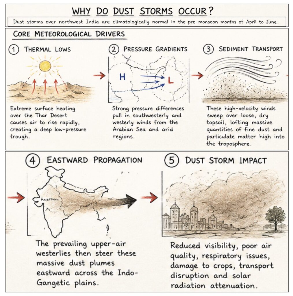
Dust storms over northwest India are climatologically normal in the pre-monsoon months of April to June.
- Core Meteorological Drivers:
- Thermal Lows: Extreme surface heating over the Thar Desert causes air to rise rapidly, creating a deep low-pressure trough.
- Pressure Gradients: Strong pressure differences pull in southwesterly and westerly winds from the Arabian Sea and arid regions.
- Sediment Transport: These high-velocity winds sweep over loose, dry topsoil, lofting massive quantities of fine dust and particulate matter high into the troposphere.
- Eastward Propagation: The prevailing upper-air westerlies then steer these massive dust plumes eastward across the Indo-Gangetic plains.
- Sources: Dust originates from two primary sources, the Thar Desert (western Rajasthan and adjoining Pakistan) and Arid West Asia and the Arabian Peninsula, whose dust plumes travel intercontinentally during the pre-monsoon season.
Changing Threshold: Signature of Barrier Degradation
- Meteorologists have noted a significant lowering of the dust-transport threshold. Nowadays, whenever the wind speed reaches 35-40 kmph, dust from Rajasthan is carried into the northern plains, which was not the case earlier.
- Previously, only intense storm events crossed the Aravalli barrier; now even moderate winds do. This is the direct signature of barrier degradation.
Consequences of the Dust Storms:
- Air quality: Fine particulate matter (PM2.5) from Thar dust compounds Delhi’s already severe winter pollution, contributing to respiratory disease, reduced visibility, and aviation disruption.
- Solar radiation: Dust aerosols scatter incoming sunlight, temporarily depressing surface temperatures (a phenomenon known as aerosol radiative forcing). While locally cooling, this disrupts the surface energy balance that drives pre-monsoon weather patterns, potentially affecting the timing and intensity of monsoon onset.
- Agriculture: Heavy dust deposition on crops reduces photosynthesis, damages leaf surfaces, and can carry fungal spores that affect crop health across Haryana, western UP, and Delhi-NCR.
Why Is the Aravalli Shield Weakening?
- Mining: The Aravallis contain commercially valuable red silica, granite, marble, quartzite, and minor minerals.
- A 2025 judicial committee found 2,339 sq km of mines in the Rajasthan portion alone (vastly exceeding the government’s officially licensed 278 sq km figure), indicating the scale of illegal extraction alongside legal mining.
- A 2018 FSI assessment found that 31 of 128 Aravalli hills in Rajasthan had already disappeared entirely, with hill loss concentrated in the 200-600 m elevation band in Naraina, Kalwar, Kotputli, Jhalana, and Sariska.
- In Haryana, the range has effectively disappeared in Charkhi Dadri and Bhiwani districts; in Mahendergarh, groundwater levels have dropped to 1,000-2,000 feet as a direct consequence of mining-driven aquifer disruption.
- Structural gaps in Aravallis: Wildlife Institute of India (2009) identified 12 gaps in the Aravalli range caused by forest degradation, inadequate vegetation cover, and topographic discontinuities. These gaps have expanded significantly and now function as wind corridors through which Thar dust bypasses the barrier entirely, advancing toward Delhi, Punjab, and western Uttar Pradesh.
- Deforestation and vegetation loss: The natural scrub-forest and thorn woodland that once covered Aravalli hillsides has been dramatically reduced by fuelwood collection, charcoal production, and livestock overgrazing. Without vegetation, hillsides lose the friction that slows wind and the root systems that bind soil, accelerating erosion and reducing the obstacle-dune trapping function.
- Invasive species: The spread of Vilayati Kikar (Prosopis juliflora), a thorny, drought-tolerant exotic shrub introduced during the colonial period, has replaced biodiverse native vegetation across large tracts of the range. Prosopis juliflora forms impenetrable thickets, outcompetes native species, reduces biodiversity, lowers groundwater tables through excessive transpiration, and provides little ecological value for wildlife or dust interception.
- Urbanisation and encroachment: Rapid expansion of Delhi-NCR, Gurugram, Faridabad, Alwar, and Jaipur has pushed construction onto Aravalli hillocks and ridge land. The MoEFCC Aravalli Restoration Framework flagged urbanisation, construction activities, land-use change, and encroachments as co-drivers of degradation alongside mining.
The Thar Desert is already advancing eastward through the Aravalli gaps. If we do not protect the Aravalli, the northern Gangetic plains would become a desert. The Indo-Gangetic plain produces approximately 40-50% of India’s food grain output.
Government Initiatives:
- Aravalli Green Wall Project (2023): Launched by MoEFCC as part of India’s commitment to combating desertification and land degradation (aligned with the UN Convention to Combat Desertification / UNCCD). Aims to restore degraded land and create a contiguous green corridor across a 5-km buffer zone flanking the Aravalli range through all four states, Delhi, Haryana, Rajasthan, and Gujarat.
- Supreme Court mining bans: The Supreme Court has issued progressive judicial orders restricting Aravalli mining since 2002, including bans in specific Haryana districts.
- In 2025, MoEFCC issued a complete ban on new mining leases across the entire Aravalli landscape, covering all four states uniformly.
- ICFRE Sustainable Mining Management Plan: The Indian Council of Forestry Research and Education has been directed by the Supreme Court to conduct an in-depth district-by-district survey and prepare a comprehensive management plan before any future mining activity is permitted.
- Eco-Sensitive Zone (ESZ) notifications: MoEFCC has notified Eco-Sensitive Zones around multiple Aravalli-based protected areas, creating buffer zones where development and extractive activity is restricted or prohibited.
- National Action Programme to Combat Desertification (NAPCD): India’s NAPCD, prepared under UNCCD obligations, identifies the Aravalli region as a priority zone for land restoration and anti-desertification investment, providing a national-level policy framework for conservation.
- ISRO Remote Sensing Monitoring: ISRO’s National Remote Sensing Centre (NRSC) conducts periodic vegetation and land-use mapping of the Aravalli landscape using satellite data, providing an evidence base for identifying encroachments, illegal mining scars, and forest-cover changes for enforcement purposes.
Despite these initiatives, enforcement remains the critical weakness. The Aravalli Green Wall Project lacks a statutory enforcement mechanism, relying on state government cooperation that has historically been inconsistent, given the economic and political power of mining lobbies.
Way Forward:
- Science-based legal definition: The Supreme Court must adopt a slope-based and geological continuity definition rather than a blunt elevation threshold. Any definition must recognise that ecologically critical low hillocks (under 100 m) perform the same barrier functions as higher ridges, and that protecting the range’s continuity matters more than protecting individual peaks.
- Real-time satellite enforcement: ISRO’s remote sensing capabilities should be deployed for continuous, automated monitoring of mining activity, canopy loss, and encroachment across the Aravalli landscape.
- Close the 12 WII gaps: The twelve structural gaps identified by WII in 2009 must be treated as a priority ecological restoration target. This requires active revegetation with native species, removal of encroachments, and legal protection equivalent to that of the ridge itself.
- Inter-State Conservation Authority: Aravallis span four states with divergent political economies and mining interests. A permanent Inter-State Aravalli Conservation Authority with statutory powers over cross-boundary land use, mining approvals, and forest governance is essential to end the state-level fragmentation.
- Community-based governance: Restoration programmes under the Aravalli Green Wall Project must involve local communities and Gram Sabhas, particularly in tribal and pastoral districts. Top-down afforestation without community buy-in has historically resulted in poor survival rates and renewed encroachment.