Join Anantam IAS Channel on Telegram

Daily Digest · Friday

29 May 2026 Current Affairs for UPSC

7 current affairs published on Friday, 29 May 2026

29 May 2026 Current Affairs for UPSC — every Why-in-News article AnantamIAS published on Friday, 29 May 2026, broken down with Why in News?, the exact GS paper it feeds, sub-topic mapping, MCQ-ready facts and a UPSC-style practice question. 7 articles in total, covering Polity, Economy, Environment, S&T, IR, Geography, History, Society and Internal Security — the same Why-in-News + GS-paper-mapping + practice-question format the Compass uses across every daily digest on the site.

Daily current affairs for UPSC is where new material enters your prep stream. Read this 29 May 2026 digest end-to-end in 25–35 minutes, attempt the practice question at the foot of each article (it's MCQ for some, 10/15-marker for others), then bookmark the entries that fall inside your active revision window. Everything stays cross-linked: tap any subject pill to jump to that subject's hub, or use the table of contents above to skip straight to a specific story.

Use this page three ways. Read sequentially for a one-sitting scan of everything that mattered on 29 May 2026. Download the 29 May 2026 PDF below for offline study or print revision. Or use the May 2026 Current Affairs compilation to see this day in the month's full context. For the previous day's reading, see 28 May 2026 Current Affairs; the next day's is 30 May 2026 Current Affairs.

Why we publish daily current affairs separately from the monthly compilation: daily is learning, monthly is revision. Use the daily page to add fresh material to your notes the day it breaks; come back to the May 2026 compilation 60 days before Prelims when the noise has settled and only the lasting takeaway is worth re-reading.

What are the Abraham Accords, and why is Trump linking them with a potential Iran deal?

Open article →Download PDF

Trump pushes Muslim leaders to join Abraham Accords after war with Iran ends
Why in News?

Donald Trump recently urged several Arab and Muslim-majority countries to normalise relations with Israel and join the Abraham Accords if a negotiated settlement to the ongoing Iran conflict is achieved.

The issue has revived debates regarding regional realignment in West Asia, the Palestinian question, Iran’s strategic role, and the future of U.S.-led diplomatic architecture in the region.

UPSC Relevance

Prelims: Abraham Accords, West Asia, Strait of Hormuz, Gulf Cooperation Council, two-state solution, Iran-Israel tensions.

Mains:
GS II – India’s relations with West Asia, geopolitical developments, international groupings, regional security; GS III – Energy security, global trade disruptions.

Background/Context

The Abraham Accords were introduced during Donald Trump’s first presidential term in 2020 as a diplomatic framework for normalisation of relations between Israel and several Arab states.

The accords represented a major geopolitical shift because many Arab nations had historically refused to formally recognise Israel after its establishment in 1948, primarily due to the unresolved Palestinian issue.

Recent attempts by the United States to expand the accords have emerged in the backdrop of:

  • escalating tensions involving Iran,
  • Israel’s continuing military operations in Gaza,
  • instability across Lebanon and Syria,
  • and growing concerns over regional security architecture.

What are the Abraham Accords?

Abraham Accords are a series of diplomatic normalisation agreements between Israel and certain Muslim-majority countries brokered by the United States.

The agreements are named after Abraham, a patriarch revered in Islam, Christianity and Judaism.

Objectives of the Accords

The accords aimed to:

  • establish diplomatic relations between Israel and Arab states,
  • promote economic and technological cooperation,
  • strengthen regional security partnerships,
  • and deepen U.S.-backed strategic alignment in West Asia.

Countries that joined the Accords

Countries that formally normalised relations with Israel include:

  • United Arab Emirates
  • Bahrain
  • Morocco

Subsequently, additional countries such as Somaliland and Kazakhstan were also reported to have joined related frameworks.

Why is Saudi Arabia Important?

Saudi Arabia remains the most significant regional power yet to formally join the Abraham Accords.

Saudi Arabia has maintained that normalisation with Israel depends upon:

  • ending the Gaza conflict,
  • and establishing a credible pathway toward an independent Palestinian state under the two-state solution framework.

Thus, Saudi Arabia’s position has become central to any future regional diplomatic settlement.

Why is Trump Linking the Iran Conflict with the Abraham Accords?

Diplomatic consolidation strategy

The United States seeks to create a broader regional coalition integrating Israel more deeply into West Asia while counterbalancing Iranian influence.

Expanding the accords after a potential Iran settlement would strengthen this regional bloc.

Projection of diplomatic success

The Abraham Accords are widely viewed as one of Trump’s major foreign policy achievements during his first term. Reviving and expanding them allows him to project an image of strategic control and diplomatic success.

Managing domestic political pressures

The Iran conflict has generated domestic political concerns within the United States because of:

  • rising fuel prices,
  • inflationary pressures,
  • fears of prolonged military involvement,
  • and declining public approval ratings.

A diplomatic breakthrough through regional normalisation could politically offset these concerns.

Iran’s Central Role in West Asian Geopolitics

Iran plays a major strategic role in West Asia due to:

  • its opposition to Israel,
  • influence over regional non-state actors,
  • energy geography,
  • and its position near the Strait of Hormuz.

The Strait of Hormuz is critical because a substantial share of global oil and gas trade passes through it. Any disruption affects global energy prices and economic stability.

Palestinian Question and Criticism of the Accords

Bypassing Palestinian statehood

One of the major criticisms of the Abraham Accords is that they largely normalised relations with Israel without resolving the Palestinian issue.

Critics argue that this weakens the long-standing Arab consensus supporting Palestinian statehood before recognition of Israel.

Public anger in the Arab world

Israel’s military operations in Gaza, Lebanon and Syria have intensified public resentment across several Arab and Muslim-majority societies.

This makes overt normalisation politically difficult for many governments despite strategic ties with the United States.

Pakistan’s position

Pakistan rejected joining the accords, arguing that recognition of Israel without an independent Palestinian state conflicts with its stated foreign policy principles.

What are the Strategic Implications of Expanding the Accords?

Greater regional integration of Israel

Expansion of the accords would deepen Israel’s diplomatic, economic and security integration within West Asia.

Containment of Iranian influence

The framework effectively creates a strategic alignment among U.S.-allied countries aimed at balancing Iran’s regional influence.

Security and defence cooperation

The accords may facilitate:

  • intelligence sharing, defence cooperation, technological partnerships and maritime security coordination.

Impact on regional power balance

If countries such as Saudi Arabia or Turkey eventually join, it could significantly reshape the geopolitical architecture of West Asia.

What are the Implications for India?

Energy security concerns

India depends heavily on energy imports from West Asia. Instability involving Iran or disruptions near the Strait of Hormuz directly affect India’s energy security and inflation levels.

Balancing regional partnerships

India maintains strong ties simultaneously with:

  • Israel, Gulf countries, and Iran.

Therefore, India must carefully balance its diplomatic engagements amid evolving regional alignments.

Connectivity and trade implications

Regional stability influences:

  • maritime trade routes, investment flows, and projects such as the India-Middle East-Europe Economic Corridor (IMEC).

Challenges to Expansion of the Abraham Accords

Palestinian issue remains unresolved

The absence of meaningful progress toward Palestinian statehood continues to limit wider regional acceptance.

Domestic political pressures in Arab countries

Public opinion in many Arab societies remains strongly sympathetic toward the Palestinian cause.

Regional instability

Conflicts in Gaza, Lebanon, Syria and tensions with Iran complicate diplomatic normalisation efforts.

Divergent strategic priorities

Countries in West Asia have differing security concerns and geopolitical calculations, making uniform alignment difficult.

Way Forward

Revive two-state negotiations

Long-term regional peace requires credible progress toward a viable Palestinian state alongside Israel.

Promote inclusive regional diplomacy

Security frameworks should incorporate broader regional interests rather than purely bloc-based alignments.

Reduce militarisation

Diplomatic engagement and de-escalation mechanisms are essential to prevent prolonged instability in West Asia.

Strengthen multilateral dialogue

Regional organisations and international actors must facilitate sustained negotiations involving all stakeholders.

Conclusion

The renewed push to expand the Abraham Accords reflects the rapidly evolving geopolitical landscape of West Asia where diplomacy, security and strategic alignments are becoming deeply interconnected. While the accords have strengthened Israel’s integration into parts of the Arab world, unresolved issues surrounding Palestine, Iran and regional security continue to limit broader acceptance. The future trajectory of the accords will significantly influence regional stability, global energy markets and the geopolitical balance of West Asia.

Practice Questions

Prelims Question 1 (Inference-based)

Consider the following statements with reference to the Abraham Accords:

I. The Abraham Accords seek to normalise diplomatic and strategic relations between Israel and certain Muslim-majority countries.
II. Expansion of the Abraham Accords is viewed by the United States as a means to strengthen a regional alignment involving Israel and U.S.-allied countries.
III. Continued instability surrounding the Palestinian issue complicates broader acceptance of the accords across West Asia.

Which of the following relationships among the above statements is/are correct?

  1. Statement II extends the geopolitical implications of Statement I by linking normalisation with regional strategic realignment.
  2. Statement III highlights a limitation affecting the broader implementation of the objectives reflected in Statement I.
  3. Statement I contradicts Statement III because diplomatic normalisation automatically resolves the Palestinian issue.

(a) 1 only
(b) 1 and 2
(c) 2 and 3
(d) 3 only

Answer: (b)

Explanation: Statement II expands upon the strategic implications of diplomatic normalisation mentioned in Statement I. Statement III identifies the unresolved Palestinian issue as a challenge to wider regional acceptance. Statement 3 is incorrect because normalisation has not automatically resolved Palestinian concerns.

Prelims Question 2 (Pairs-based)

Consider the following pairs:

EntitySignificance
1. Strait of HormuzStrategic maritime route for global oil trade
2. Abraham AccordsAgreements aimed at normalisation between Israel and Arab states
3. Two-state solutionProposal for merger of Israel and Palestine into a single federal state

Which of the pairs given above are correctly matched?

(a) 1 and 2 only
(b) 2 and 3 only
(c) 1 and 3 only
(d) 1, 2 and 3

Answer: (a)

Explanation: Pair 3 is incorrect because the two-state solution refers to the creation of an independent Palestinian state alongside Israel, not a single merged federal state.

Mains Questions

  1. Discuss the challenges faced in expanding the Abraham Accords in the context of the Palestinian issue and regional instability.
  2. Examine the geopolitical significance of the Abraham Accords in reshaping power dynamics in West Asia.
India, China hold talks on Border Delimitation 

Open article →Download PDF

Why in News?

The 35th meeting of the Working Mechanism for Consultation and Coordination on India-China Border Affairs (WMCC) was held in Beijing, China. Both sides described discussions as “constructive and forward-looking” and agreed to maintain regular diplomatic and military-level exchanges. 

India stressed the need for an early meeting of the Expert Level Mechanism on Trans-Border Rivers. Both sides agreed to prepare for the next round of Special Representatives (SR) Talks, to be held in China.

UPSC Relevance: GS-2 International Relations: Bilateral Relations 

Mains: India – China bilateral relations: Significance and Challenges 

The India-China Border:

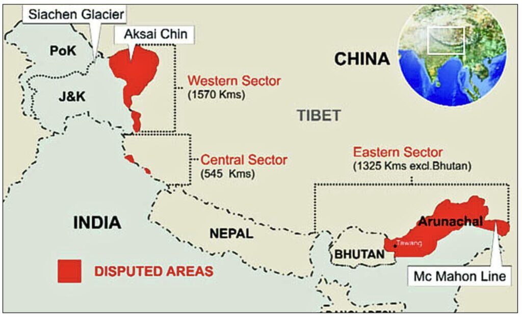
  • The India-China border remains un-demarcated and is referred to as the Line of Actual Control (LAC). 
  • India’s official position places its length at approximately 3,488 km, while China claims it to be roughly 2,000 km. This fundamental disagreement over the very length of the boundary is itself a driver of disputes.

The border is conventionally divided into three sectors: 

  • The Western Sector (Ladakh, ~1,597 km) is the most disputed, involving Aksai Chin (~38,000 sq. km) under Chinese occupation and the Shaksgam Valley (~5,800 sq. km) ceded by Pakistan to China under the 1963 Sino-Pakistan Boundary Agreement. 
  • The Middle Sector (Himachal Pradesh and Uttarakhand, ~545 km) is the least contentious, though differences persist near the Barahoti plains. 
  • The Eastern Sector (Arunachal Pradesh and Sikkim, ~1,346 km) is where China claims approximately 90,000 sq. km of Arunachal Pradesh as “South Tibet” and disputes the McMahon Line.

Historical Trajectory of the Dispute: 

The modern boundary dispute has colonial-era roots. 

  • The 1914 Simla Convention drew the McMahon Line between British India and Tibet. China rejected the line, arguing that Tibet lacked the legal authority to negotiate a bilateral boundary.
  • China’s incorporation of Tibet in 1950, and its covert construction of a road through Aksai Chin in the 1950s (which India discovered only in 1957), set the stage for the 1962 Sino-Indian War. The war ended with a Chinese unilateral ceasefire; China retained Aksai Chin but withdrew from its advances in Arunachal Pradesh, leaving the boundary unresolved and relations severely damaged.
  • Prime Minister Rajiv Gandhi’s 1988 visit to Beijing (the first by an Indian PM in 34 years) formally reopened dialogue. The subsequent period saw the structured institutionalisation of border management beginning with six rounds of the Joint Working Group (JWG) between 1988 and 1993, and the first direct military-level contact meetings at Bum La (Eastern Sector) and Chushul/Moldo (Western Sector) in 1992. Border trade (suspended for over 30 years) also resumed in 1992, and consulates were reopened in Mumbai and Shanghai in December 1992.
  • Border Peace and Tranquillity Agreement (BPTA), 1993 formally introduced the concept of the Line of Actual Control into official bilateral documents for the first time, committed both sides not to use or threaten force, and required each to withdraw forces to their side of the LAC if intrusions occurred. Crucially, it froze the military situation in place rather than resolving the underlying territorial dispute.
  • The 1996 Agreement on Confidence-Building Measures added specificity to the BPTA by capping or banning certain categories of weaponry (tanks, artillery, missiles) in border zones, restricting large-scale military exercises near the LAC, and committing both sides to exchange maps for LAC clarification. 
  • In 2000, maps of the relatively uncontested Central Sector were exchanged. However, a 2002 attempt to exchange Western Sector maps failed immediately, as both sides presented maximalist interpretations. By 2005, efforts to achieve a common understanding of the LAC were abandoned entirely, leaving Depsang, Pangong Tso, Demchok, and Chumar as future flashpoints.
  • The 2020 Galwan Crisis: In March-April 2020, the PLA undertook a large-scale forward deployment across multiple friction points in eastern Ladakh (Galwan Valley, Pangong Tso (north and south banks), Gogra, Hot Springs, Depsang, and Demchok). The situation escalated catastrophically in June 2020, when hand-to-hand combat in the Galwan Valley resulted in the deaths of 20 Indian soldiers and an unconfirmed number of Chinese casualties. It was the most serious military confrontation between the two sides since 1967.
  • Disengagement was achieved in phases. By 2022, four of the six friction points (Gogra, Hot Springs, and both banks of Pangong Tso) had been de-escalated through a combination of WMCC meetings, Corps Commander-level talks, and diplomatic back-channels. Depsang and Demchok remained deadlocked.
  • In 2024, India’s Foreign Secretary announced a patrolling agreement for Depsang and Demchok, restoring pre-April 2020 patrol arrangements.

The Institutional Architecture: WMCC and SR Talks

India and China maintain a layered diplomatic and military architecture for border management. 

  • At the military level, Corps Commander-level talks are held at Chushul/Moldo (Western Sector), with local Brigade/Division commander meetings for on-ground coordination. 
  • At the diplomatic level, the WMCC (established in 2012) serves as the primary coordination body for border affairs, meeting roughly quarterly. 
  • At the strategic level, the Special Representatives mechanism is the highest-level dedicated boundary dialogue, empowered to explore the political framework for a final settlement.

The 35th WMCC meeting specifically discussed: (i) boundary delimitation; (ii) border management; (iii) mechanism building; and (iv) cross-border cooperation. 

India’s push for an early meeting of the Expert Level Mechanism on Trans-Border Rivers is particularly significant given concerns about China’s dam construction on the Yarlung Tsangpo (upper Brahmaputra) and the withholding of hydrological data during flood seasons.

Strategic Significance of India-China Stability:

  • Economic Interdependence: China is India’s largest trading partner by bilateral trade volume and its third-largest export destination.
    • The Indian pharmaceutical sector depends on China for approximately two-thirds of its Active Pharmaceutical Ingredients (APIs). 
    • Solar modules, rare-earth metals, and tunnel boring machines critical to infrastructure projects are predominantly sourced from China. 
    • China controls roughly 90% of global rare-earth production, an enormous strategic leverage point over India’s clean-energy and defence-technology ambitions.
  • Transboundary River Security: China’s construction of the world’s largest hydroelectric dam on the Yarlung Tsangpo (announced in 2024 and under development) raises serious concerns about India’s downstream water security on the Brahmaputra, and about the potential weaponisation of water flows during a conflict. The Expert Level Mechanism on Trans-Border Rivers, whose early convening India stressed at the 35th WMCC, is the only bilateral platform for sharing hydrological and flood-warning data.
  • Energy Geopolitics: As the world’s two largest Asian oil importers, India-China cooperation could substantially improve their collective bargaining position against the so-called “Asian Premium”, the price differential that Asian importers pay over Western buyers for the same crude.
  • Multilateral Leverage: China’s support remains consequential for India’s pursuit of permanent UNSC membership and full membership in the Nuclear Suppliers Group (NSG), both of which China has historically blocked or complicated. A stable bilateral relationship also enhances India’s credibility in multilateral forums such as the G20, BRICS, and the Shanghai Cooperation Organisation (SCO), where both are major actors. 

Border stability between India and China would prevent future clashes & allow resources to be diverted to developmental priorities. 

Persistent Challenges: 

  • The China-Pakistan Axis: China’s strategic partnership with Pakistan remains the most visceral complication in India-China normalisation. During India’s Operation Sindoor (2025), the China-Pakistan security nexus became acutely visible. Pakistan deployed Chinese-supplied J-10C fighter jets and PL-15 air-to-air missiles. The conflict and China’s role in enabling Pakistan’s capabilities has significantly deepened Indian strategic mistrust of Beijing.
  • Taiwan and the One-China Policy: A diplomatic controversy arose when the Chinese readout suggested the Indian EAM had acknowledged Taiwan as part of China. India officially clarified that its long-standing “One China Policy” remained unchanged, and that relations with Taiwan remain economic, cultural, and technological in nature, without formal diplomatic recognition. The gap between Indian and Chinese narratives on this issue illustrates how each side frames diplomatic interactions through domestic political lenses.
  • China’s Export Restrictions: India is increasingly alarmed by China’s selective export restrictions on rare-earth materials, tunnel boring machines, and certain fertiliser precursors. Given India’s critical dependence on Chinese rare earths for EV battery production, renewable energy deployment, and advanced electronics, any expansion of such restrictions carries serious supply-chain implications.
  • The Brahmaputra Dam: China’s decision to proceed with a mega-dam project on the Yarlung Tsangpo without consulting India or Bhutan raises concerns under international norms of equitable water use for transboundary rivers. The absence of a legally binding water-sharing treaty between India and China means India has no formal legal recourse beyond diplomatic negotiation. 

Structural Trust Deficit: Despite the October 2024 disengagement and subsequent diplomatic momentum, India’s strategic community remains cautious. The fundamental question: whether China’s current cooperative posture reflects a genuine strategic recalculation or a tactical pause driven by external pressures (trade friction with the US, post-Operation Sindoor scrutiny of its weapons), is yet to be answered. 

Way Forward: 

Resolving the India-China boundary question is a generational project requiring simultaneous action across diplomatic, military, legal, and domestic institutional tracks.

  • Diplomatic: Pursue the next SR Talks in China with a specific agenda on delimitation in the Western Sector. Use the WMCC format to institutionalise a Trans-Border Rivers agreement before the next monsoon season.
  • Military CBMs: Revive the 1996 commitment to exchange and jointly verify LAC maps — starting with the less contentious Middle Sector. Establish a joint incident-prevention hotline at the Corps Commander level.
  • Strategic Autonomy: Reduce dependence on Chinese rare earths through the Critical Minerals Mission, acceleration of the India Semiconductor Mission, and deeper engagement with Quad partners on supply-chain resilience.
  • Border Infrastructure: Continue investment in the Border Roads Organisation’s target of connecting all villages in Arunachal Pradesh with all-weather roads. Expand forward air bases and ammunition pre-positioning in Ladakh.
  • Multilateral Leverage: Use India’s Quad, G20, and SCO platforms to establish a multilateral context that incentivises Chinese restraint, including support for international norms on transboundary rivers, AI in warfare, and export restrictions.

While diplomatic engagement has helped restore stability, the fundamental challenge remains the absence of a mutually accepted boundary. Sustainable peace will require not merely managing incidents along the LAC but addressing the underlying issue of boundary delimitation. 

UPSC PYQ 2017:

Q. China is using its economic relations and positive trade surplus as tools to develop potential military power status in Asia. In the light of this statement, discuss its impact on India as her neighbour.

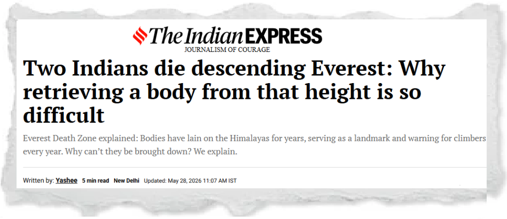
Two Indians die descending Everest: Why retrieving a body from that height is so difficult

Open article →Download PDF

Why in News?

Two Indian climbers died while descending Mount Everest during the 2026 climbing season. While the body of one climber could be recovered, another climber who died close to the summit could not be retrieved because of the extreme conditions prevailing in the “Death Zone”.

The incident has once again highlighted the dangers of high-altitude mountaineering, the immense logistical challenges involved in rescue operations above 8,000 metres, and growing concerns regarding overcrowding and environmental degradation on Everest.

UPSC Relevance

Prelims: Mount Everest, Death Zone, High-Altitude Cerebral Oedema (HACE), High-Altitude Pulmonary Oedema (HAPO), Sherpas, Himalayan ecology.

Mains:
GS I – Physical geography of the Himalayas;
GS III – Disaster management, environmental sustainability, tourism management and mountain ecology.

Background/Context

Mount Everest, located on the Nepal-China border in the Himalayas, stands at 8,848 metres and is the highest mountain peak in the world. Every year, hundreds of climbers attempt to scale the mountain despite extreme weather conditions and severe physiological risks.

However, Everest is also associated with recurring fatalities caused by oxygen deprivation, exhaustion, avalanches, frostbite and overcrowding near the summit route. Bodies of climbers often remain on the mountain for years because recovery operations in the upper reaches are technically difficult, financially expensive and highly dangerous.

Several climbers who died on Everest have become grim landmarks for mountaineers. One of the most famous examples is “Green Boots”, believed to be the body of Indian climber Tsewang Paljor, whose remains remained visible along a summit route for decades. Another well-known case is that of American climber Francys Arsentiev, often referred to as “Sleeping Beauty”.

What is the “Death Zone”?

The region above 8,000 metres on Mount Everest is known as the “Death Zone”. At this altitude, atmospheric pressure falls drastically and oxygen availability declines to nearly one-third of sea-level concentration.

Even acclimatised climbers cannot survive there for prolonged periods because the human body gradually begins to deteriorate under conditions of severe oxygen scarcity and extreme cold.

Physiological Challenges in the Death Zone

Climbers in the Death Zone often experience severe physical and mental stress. Reduced oxygen levels impair judgement, weaken muscular coordination and increase fatigue.

One of the major medical risks is High-Altitude Cerebral Oedema (HACE), a condition in which fluid accumulates in the brain due to oxygen deprivation. It may lead to confusion, hallucinations, loss of coordination and unconsciousness.

Another serious condition is High-Altitude Pulmonary Oedema (HAPO), where fluid accumulates in the lungs, causing severe breathlessness and respiratory distress. Both conditions can become fatal if immediate descent is not possible.

Combined with freezing temperatures, high wind speeds and frostbite risks, these factors make survival in the Death Zone extremely difficult.

Why is Retrieving Bodies from Everest So Difficult?

Extreme altitude and oxygen scarcity

Rescuers themselves face life-threatening risks in the Death Zone because prolonged exposure to low oxygen levels can impair both physical and mental functioning.

Harsh terrain and weather conditions

The upper reaches of Everest contain steep ice walls, slippery rock faces, narrow ridges and deep crevasses, making coordinated rescue operations extremely difficult. In several sections, only one climber can move at a time.

The freezing temperatures further worsen conditions, while sudden storms and poor visibility make descent operations highly risky.

Bodies freeze rapidly at high altitude

At such extreme altitudes, bodies freeze quickly and often become embedded in snow and ice. Rescue teams may need to dig bodies out under hostile weather conditions where even handling tools becomes difficult.

Bodies also become extremely heavy during recovery because they are frozen stiff, making transportation through narrow mountain passages extremely challenging.

Limited rescue infrastructure

Helicopters struggle to operate effectively at such high altitudes because thin air reduces lift generation. As a result, recovery missions largely depend on manual efforts by Sherpas and rescue teams.

According to mountaineering experts, retrieving a body from near the summit may require 8–10 trained Sherpas, specialised ropes, oxygen cylinders and multiple expedition days. Consequently, the cost of such an operation can reach nearly ₹1 crore.

The Role of Sherpas in Everest Expeditions

Sherpas play a central role in Himalayan mountaineering expeditions. They assist climbers in route fixing, carrying supplies, setting up camps, rescue operations and body recovery missions.

Despite their expertise, Sherpas face disproportionate risks because they repeatedly move through hazardous sections of the mountain while supporting commercial expeditions.

What is the 2 PM Rule on Everest?

To reduce fatalities during summit attempts, the Nepal government and expedition agencies increasingly enforce the “2 PM Rule”. Under this rule, climbers are expected to begin descending by 2 PM irrespective of whether they have reached the summit.

The rationale behind the rule is that weather conditions on Everest can deteriorate rapidly during the afternoon. Storms may develop suddenly, temperatures may fall sharply and darkness can reduce visibility, making the already dangerous descent even riskier.

Studies and rescue data suggest that more deaths occur during descent than ascent because climbers are physically exhausted after summit attempts and often continue climbing despite deteriorating health conditions.

Environmental and Governance Concerns on Everest

The increasing commercialisation of Everest expeditions has raised serious environmental and governance concerns. Overcrowding near summit routes frequently creates traffic bottlenecks, increasing climbers’ exposure time in the Death Zone.

The mountain has also witnessed growing accumulation of discarded oxygen cylinders, plastic waste, abandoned tents and human remains, threatening the fragile Himalayan ecosystem.

In response, Nepal has launched several clean-up campaigns aimed at removing waste and recovering bodies from Everest and nearby peaks. However, many climbers are still believed to be missing in the Himalayan region.

Broader Lessons from Everest Fatalities

The recurring fatalities on Everest underline the severe physiological limitations humans face in extreme environmental conditions. They also highlight the tensions between adventure tourism, commercial mountaineering and ecological sustainability.

The rising number of climbers attempting Everest every year has intensified debates regarding stricter safety regulations, better rescue infrastructure and limits on overcrowding.

At a broader level, these incidents demonstrate the importance of balancing tourism revenue with environmental conservation and human safety in fragile mountain ecosystems.

Way Forward

Strengthening safety regulations

Authorities should enforce stricter acclimatisation protocols, oxygen requirements and turnaround-time rules to reduce preventable deaths.

Improving rescue capabilities

Investment in specialised high-altitude rescue training, weather forecasting systems and emergency infrastructure can improve survival outcomes.

Regulating overcrowding

Limiting permits during peak climbing seasons may help reduce congestion near summit routes and minimise exposure in the Death Zone.

Promoting sustainable mountain tourism

Environmentally responsible expedition practices, effective waste-management systems and stronger ecological conservation measures are essential for protecting the Himalayan ecosystem.

Conclusion

The deaths of climbers on Mount Everest once again reveal the immense dangers associated with high-altitude mountaineering. The “Death Zone” represents one of the harshest environments faced by humans, where oxygen scarcity, freezing temperatures and difficult terrain make survival itself uncertain.

Beyond individual tragedies, the issue raises broader concerns regarding sustainable tourism, environmental protection and governance of the Himalayan ecosystem. As commercial mountaineering continues to expand, balancing adventure tourism with ecological sustainability and human safety will become increasingly important.

Practice Questions

Prelims Question 1 (Inference-based)

Consider the following statements with reference to the “Death Zone” on Mount Everest:

I. The Death Zone refers to altitudes above 8,000 metres where oxygen availability becomes critically low for human survival.
II. Rescue and body retrieval operations in the Death Zone are highly risky because extreme altitude and terrain severely constrain human functioning and logistics.
III. Safety regulations such as the “2 PM Rule” aim to reduce fatalities associated with high-altitude climbing.

Which of the following relationships among the above statements is/are correct?

  1. Statement II explains the operational challenges arising from the environmental conditions mentioned in Statement I.
  2. Statement III represents an administrative response intended to mitigate risks associated with the conditions described in Statements I and II.
  3. Statement I contradicts Statement III because climbers above 8,000 metres cannot be subjected to safety regulations.

(a) 1 only
(b) 1 and 2
(c) 2 and 3
(d) 3 only

Answer: (b)

Explanation: Statement II logically explains why rescue operations become extremely difficult in the Death Zone. Statement III further shows how administrative measures seek to reduce the risks associated with extreme-altitude climbing. Statement 3 is incorrect.

Prelims Question 2

Consider the following pairs:

TermDescription
1. High-Altitude Cerebral Oedema (HACE)Fluid accumulation affecting the brain at high altitude
2. High-Altitude Pulmonary Oedema (HAPO)Fluid accumulation in lungs due to altitude-related oxygen deficiency
3. SherpasIndigenous Arctic rescue community specialised in polar expeditions

Which of the pairs given above are correctly matched?

(a) 1 and 2 only
(b) 2 and 3 only
(c) 1 and 3 only
(d) 1, 2 and 3

Answer: (a)

Explanation: Pair 3 is incorrect because Sherpas are a Himalayan ethnic community associated with mountaineering expeditions in Nepal and surrounding Himalayan regions.

Mains Questions

  1. Discuss the environmental and governance challenges associated with increasing commercialisation of Mount Everest expeditions.
  2. Examine the physiological and logistical challenges involved in high-altitude rescue operations in the Himalayas.

Brinkmanship in the age of growing conflict 

Open article →Download PDF

Why in News?

The ongoing tensions involving Iran’s temporary closure of the Strait of Hormuz, the United States’ economic blockade measures, the Russia-Ukraine conflict, and rising tensions in the Indo-Pacific have once again brought the concept of “brinkmanship” into focus.

The increasing use of coercive diplomacy, proxy conflicts, economic pressure, maritime blockades and nuclear signalling indicates a shift in global geopolitics where countries are increasingly relying on escalation tactics instead of traditional diplomacy.

UPSC Relevance

Prelims: Strait of Hormuz, brinkmanship, proxy wars, NATO, South China Sea, Cuban Missile Crisis, Cold War.

Mains:
GS II – International relations, global geopolitics, role of international institutions;
GS III – Security challenges, terrorism, nuclear deterrence, maritime security.

What is Brinkmanship?

Brinkmanship refers to a strategy in international relations where a country deliberately pushes a conflict or crisis situation to the edge of war or severe escalation in order to force the adversary to retreat, negotiate or concede.

The term became prominent during the Cold War era, particularly while analysing events such as the Berlin Blockade (1948–49) and the Cuban Missile Crisis (1962), where rival powers escalated tensions dangerously close to direct military confrontation.

Brinkmanship operates on the logic that controlled escalation and the threat of catastrophic consequences can compel opponents to alter their behaviour without actual full-scale war taking place.

However, the strategy is inherently risky because miscalculation, misunderstanding or accidental escalation can trigger uncontrollable conflict.

Historical Evolution of Brinkmanship

Cold War origins

During the Cold War, brinkmanship was primarily associated with nuclear deterrence between the United States and the Soviet Union. Both powers repeatedly demonstrated military capability and strategic resolve while avoiding direct confrontation.

The Cuban Missile Crisis is often regarded as the most dangerous example of brinkmanship, where the world came close to nuclear war before diplomatic negotiations helped de-escalate the crisis.

Post-Cold War transformation

After the Cold War, the nature of brinkmanship expanded beyond conventional military threats. New dimensions such as terrorism, proxy warfare, cyber conflict, maritime coercion and economic sanctions became important tools of strategic pressure.

Unlike the bipolar Cold War system, the present global order involves multiple actors, including regional powers and non-state groups, making conflict management far more complex.

Contemporary Forms of Brinkmanship

Terrorism as a Tool of Brinkmanship

In the modern era, terrorism has emerged as a major instrument of brinkmanship. Non-state actors often provoke stronger states into disproportionate military responses to gain international attention, strengthen recruitment or deepen political polarisation.

Groups such as al-Qaeda and the Islamic State attempted to use spectacular acts of violence to provoke large-scale geopolitical reactions. However, most globally designated terrorist organisations have largely failed to achieve their long-term strategic objectives.

At the same time, some historical insurgent movements such as the Irish Republican Army (IRA) or Algeria’s National Liberation Front (FLN) managed to extract political concessions through prolonged asymmetric conflict.

Proxy Brinkmanship

Another major feature of contemporary geopolitics is proxy brinkmanship, where states indirectly challenge stronger powers through non-state armed groups, militias or ideological proxies.

Countries use proxies because direct confrontation with militarily superior powers may be too costly or risky. Such strategies aim to gradually weaken the adversary’s political will, economic capacity or regional influence.

The Hamas attack on Israel in October 2023 and the subsequent escalation in Gaza reflected the dangers associated with proxy conflicts and retaliatory escalation.

Similarly, Iran’s regional proxy networks and Pakistan’s historical use of cross-border militant groups illustrate how asymmetric tactics are employed to pursue strategic objectives without direct conventional war.

Economic and Maritime Brinkmanship

Economic sanctions, blockades and control over strategic maritime chokepoints have increasingly become instruments of geopolitical pressure.

Strait of Hormuz and global energy security

The Strait of Hormuz is one of the world’s most important maritime chokepoints through which a substantial portion of global oil and gas supplies passes.

Any disruption in this region has immediate consequences for global energy markets, inflation and international trade.

Iran’s threats regarding the Strait of Hormuz represent a form of asymmetric brinkmanship aimed at leveraging geography against stronger military powers.

Sanctions and economic coercion

The United States has frequently relied on sanctions, financial restrictions and trade controls to pressure adversaries such as Iran, Russia and North Korea.

Economic coercion allows countries to exert pressure without direct military confrontation. However, prolonged sanctions may also intensify geopolitical tensions and encourage counter-alignment among rival powers.

Russia and Nuclear Brinkmanship

Russia’s conflict with Ukraine has revived concerns regarding nuclear signalling and escalation management.

Since the beginning of the Russia-Ukraine war in 2022, Russian leadership has repeatedly invoked nuclear rhetoric and showcased strategic military capabilities to deter Western intervention.

The continued use of hypersonic missiles, long-range strikes and threats regarding NATO expansion demonstrate how brinkmanship is used both militarily and psychologically.

The conflict also reveals how prolonged wars can generate continuous escalation cycles that become increasingly difficult to control diplomatically.

China’s Strategy of Controlled Brinkmanship

China has increasingly adopted calibrated coercive strategies in the South China Sea and East China Sea.

Its island-building activities, maritime militia operations and territorial claims are often designed to gradually alter the status quo without triggering full-scale war.

This strategy is sometimes described as “salami slicing”, where incremental actions collectively produce major strategic gains over time.

Countries such as Vietnam, the Philippines and Malaysia have faced sustained pressure in the South China Sea, while Japan has resisted Chinese coercion regarding the Senkaku Islands.

Taiwan remains one of the most sensitive flashpoints in contemporary geopolitics because any escalation there could potentially trigger a major international conflict.

North Korea and Nuclear Deterrence

North Korea represents one of the clearest examples of brinkmanship in the 21st century.

Despite limited economic capabilities, North Korea has used missile testing, nuclear development and strategic unpredictability to deter external intervention and strengthen regime survival.

Its actions repeatedly generate regional tensions involving South Korea, Japan and the United States, while simultaneously forcing global powers to negotiate under conditions of uncertainty.

Why is Brinkmanship Becoming More Common?

Several structural factors are contributing to the increasing use of brinkmanship in global politics.

Weakening of multilateral institutions

Institutions such as the United Nations have struggled to effectively manage major geopolitical crises due to divisions among powerful countries.

As confidence in collective security mechanisms weakens, countries increasingly resort to unilateral pressure tactics.

Rise of multipolarity

The contemporary global order is becoming more multipolar, with powers such as China, Russia, India, the European Union and regional actors asserting greater strategic autonomy.

This diffusion of power has increased geopolitical competition and reduced the predictability associated with the earlier bipolar order.

Technological transformation of warfare

Modern technologies such as cyber warfare, drones, hypersonic missiles, artificial intelligence and space capabilities have expanded the spectrum of conflict below the threshold of conventional war.

These tools allow states to escalate pressure while maintaining ambiguity and deniability.

Decline of traditional diplomacy

Many countries increasingly prefer coercive diplomacy, sanctions and military signalling over prolonged negotiations.

As geopolitical rivalries intensify, diplomacy is often viewed as slower and less effective compared to strategic coercion.

India’s Approach Towards Brinkmanship

India has traditionally followed a strategic culture based on restraint, calibrated response and responsible use of force.

Even during severe provocations, India has generally avoided uncontrolled escalation while simultaneously demonstrating military and diplomatic resolve.

India’s approach combines deterrence with strategic autonomy and diplomatic engagement. This has been visible in India’s handling of border tensions, counter-terror operations and regional diplomacy.

At the same time, India continues to emphasise the importance of multilateralism, peaceful dispute resolution and respect for international law.

What are the Challenges Posed by Growing Brinkmanship?

Risk of accidental escalation

As multiple powers engage in aggressive signalling and military posturing, the possibility of unintended conflict increases significantly.

A miscalculation or communication failure can rapidly escalate regional crises into broader confrontations.

Threat to global economy

Maritime disruptions, sanctions and conflicts around strategic chokepoints directly affect global trade, energy prices and supply chains.

This creates inflationary pressures and economic instability worldwide.

Erosion of international norms

Frequent resort to coercion weakens international law, sovereignty principles and institutional dispute-resolution mechanisms.

Humanitarian consequences

Proxy wars and prolonged conflicts often produce severe civilian suffering, displacement, food insecurity and destruction of infrastructure.

Way Forward

Revitalising diplomacy

Countries must prioritise sustained diplomatic engagement, confidence-building measures and crisis communication channels to prevent escalation.

Strengthening multilateral institutions

Reforms in institutions such as the United Nations are necessary to improve global conflict-management mechanisms.

Enhancing strategic restraint

Major powers must avoid excessive military signalling and maintain transparency in strategic communication.

Regulating emerging technologies

International norms regarding cyber warfare, artificial intelligence and hypersonic weapons are essential to reduce instability.

Promoting regional cooperation

Regional dialogue mechanisms can help address disputes before they escalate into larger confrontations.

Conclusion

The return of brinkmanship reflects the growing instability and fragmentation of the contemporary geopolitical order. Unlike the Cold War period, today’s conflicts involve multiple actors, proxy networks, technological complexities and economic interdependence, making escalation management far more difficult.

As diplomacy increasingly gives way to coercion and strategic signalling, the risks of miscalculation and prolonged conflict continue to rise. In such a scenario, strengthening international cooperation, strategic restraint and peaceful conflict resolution mechanisms becomes essential for maintaining global stability.

Practice Questions

Prelims Question 1 (Inference-based)

Consider the following statements with reference to brinkmanship in international relations:

I. Brinkmanship involves pushing a conflict situation close to escalation in order to compel the adversary to alter its behaviour.
II. Contemporary brinkmanship increasingly includes economic coercion, proxy conflicts and maritime pressure tactics alongside conventional military threats.
III. Weakening multilateral institutions and rising geopolitical competition have contributed to the growing use of brinkmanship in global politics.

Which of the following relationships among the above statements is/are correct?

  1. Statement II expands the traditional Cold War understanding of brinkmanship referred to in Statement I.
  2. Statement III explains some of the structural conditions encouraging the trends mentioned in Statement II.
  3. Statement I contradicts Statement III because brinkmanship can occur only in a bipolar world order.

(a) 1 only
(b) 1 and 2
(c) 2 and 3
(d) 1, 2 and 3

Answer: (b)

Explanation: Statement II broadens the traditional understanding of brinkmanship beyond military confrontation. Statement III explains the systemic geopolitical conditions encouraging such practices. Statement 3 is incorrect because brinkmanship can occur in both bipolar and multipolar systems.

Prelims Question 2

Assertion (A): The Strait of Hormuz is considered strategically significant in global geopolitics.

Reason (R): A substantial portion of global oil and gas trade passes through the Strait of Hormuz.

(a) Both A and R are true, and R is the correct explanation of A.
(b) Both A and R are true, but R is not the correct explanation of A.
(c) A is true, but R is false.
(d) A is false, but R is true.

Answer: (a)

Explanation: The Strait of Hormuz is a critical maritime chokepoint through which a major share of global energy supplies passes, making it strategically significant in global geopolitics.

Mains Questions

  1. “The nature of brinkmanship has transformed significantly in the post-Cold War era.” Discuss with suitable examples.
  2. Examine the implications of proxy conflicts and economic coercion on global peace and stability in the contemporary world order.

Govt. plans security protocol for fishing harbours under CISF oversight

Open article →Download PDF

Why in News?

The Union Home Ministry is planning to bring around 1,200 fishing harbours and fish landing centres under a security oversight framework guided by the Central Industrial Security Force (CISF).

The move is aimed at strengthening India’s coastal security architecture, plugging surveillance gaps, and creating a more uniform security mechanism across fishing hubs and maritime infrastructure, particularly in the aftermath of vulnerabilities exposed during the 26/11 Mumbai terror attacks.

UPSC Relevance

Prelims: CISF, coastal security, Bureau of Port Security (BoPS), Indian Coast Guard, maritime security, 26/11 attacks.

Mains:
GS II – Governance, Centre-State coordination, internal security;
GS III – Coastal security, border management, maritime infrastructure, terrorism.

Background: Why Coastal Security is Important

India has a coastline of approximately 7,516 km spread across 13 coastal States and Union Territories. Along this coastline are major ports, fishing harbours, fish landing centres, naval facilities, coastal settlements, and busy shipping routes that are crucial for India’s economy and security.

The significance of coastal security became especially evident after the 26/11 Mumbai terror attacks in 2008, when terrorists entered India through the sea route after hijacking an Indian fishing vessel near the coast. The incident exposed serious weaknesses in maritime surveillance, harbour security, identity verification systems, and coordination among multiple agencies.

Since then, India has gradually strengthened its maritime security architecture through institutional reforms, coastal radar systems, and greater coordination between the Navy, Coast Guard and marine police.

What is the Government’s New Proposal?

The Ministry of Home Affairs proposes to bring fishing harbours and landing sites under an overall security framework supervised by the CISF. However, CISF personnel are unlikely to be physically deployed at every harbour because of the large number of sites spread across the coastline.

Instead, the CISF is expected to function as a central security regulator and advisory institution that will help local administrations design standardised security mechanisms. The force will assist in developing uniform operational procedures, surveillance systems, and risk-management protocols across fishing harbours.

The objective is to remove the present fragmentation in coastal security arrangements and establish a more coordinated national framework.

Proposed Security Measures

Technology-driven monitoring systems

The government plans to regulate the movement of fisherfolk through biometric attendance systems and smart identification cards. This would help authorities identify genuine fishermen, prevent unauthorised access to sensitive coastal zones, and improve real-time monitoring of harbour activities.

The use of digital systems is also expected to strengthen database integration and assist security agencies in identifying suspicious movements more efficiently.

Standardised harbour security framework

At present, different coastal regions follow varying security practices depending on local administrative arrangements. The CISF is expected to create a common security template covering areas such as entry and exit regulation, CCTV surveillance, vessel monitoring, digital registration systems, security audits, and emergency response mechanisms.

Such standardisation would improve coordination among agencies and reduce gaps in surveillance and enforcement.

Community participation in security

Fishing communities are often the first observers of unusual maritime activity. The proposed framework also seeks to sensitise local populations regarding coastal security threats and encourage cooperation between fisherfolk and security agencies.

This reflects the broader understanding that coastal security cannot rely only on armed forces and surveillance technology, but also requires active community participation.

Existing Coastal Security Architecture in India

India’s coastal security system currently involves several agencies operating at different levels.

State police and marine police are responsible for near-shore patrolling and local intelligence gathering. The Indian Coast Guard conducts maritime surveillance, anti-smuggling operations, and search-and-rescue missions, while the Indian Navy handles deeper maritime defence and strategic security responsibilities.

The CISF currently provides security to all 13 major ports in the country and has increasingly emerged as the central agency responsible for port-security regulation. The government has also designated the CISF as the security regulator for over 250 seaports, including private cargo ports.

However, because multiple agencies operate simultaneously, concerns have often been raised regarding coordination gaps and the absence of a uniform security framework.

Bureau of Port Security (BoPS)

In December 2025, the Union Home Minister proposed the establishment of the Bureau of Port Security (BoPS). The proposed body is expected to function on the lines of the Bureau of Civil Aviation Security (BCAS), which regulates airport security in India.

The BoPS is intended to create national standards for port and maritime security, coordinate among different agencies, conduct inspections and audits, and ensure compliance with security protocols across ports and coastal infrastructure.

The proposed institution reflects the government’s attempt to move towards a more integrated and centralised maritime security architecture.

Why Fishing Harbours are Strategically Sensitive

Fishing harbours and landing centres involve constant movement of people and vessels, informal economic activities, and large stretches of relatively less-monitored coastal areas. Small fishing boats can sometimes escape surveillance due to weak registration and tracking systems.

This creates vulnerabilities related to smuggling, illegal fishing, infiltration, and even possible terrorist movement through maritime routes. Strengthening security in these areas is therefore important not only for counter-terrorism but also for improving maritime domain awareness and protecting coastal economic infrastructure.

Challenges in Implementing the Framework

Large-scale implementation difficulties

India has more than 1,500 notified fishing harbours and landing centres distributed across mainland and island territories. Ensuring uniform implementation of security systems across such a vast and geographically dispersed network will be administratively challenging.

Centre-State coordination issues

Fishing harbours are managed by both State governments and Central agencies. Effective coordination among multiple authorities, each with different administrative structures and priorities, remains a major challenge.

Financial and technological limitations

Installing surveillance infrastructure, biometric systems, vessel-tracking mechanisms, and digital databases across remote coastal areas will require significant financial investment and technological capacity.

Balancing security with livelihoods

Fishing communities depend on flexible and continuous access to coastal areas for their livelihoods. Excessive regulation or cumbersome verification procedures may create inconvenience and resistance among local populations if not implemented sensitively.

Importance of Maritime Security for India

India’s strategic location in the Indian Ocean Region makes maritime security a critical component of national security. Nearly 95% of India’s trade by volume and a major share of its energy imports move through sea routes.

As a result, secure ports, fishing zones and coastal infrastructure are vital for economic stability, uninterrupted energy supplies, national defence preparedness, and counter-terrorism efforts. With increasing geopolitical competition in the Indo-Pacific region, maritime security has also become central to India’s broader strategic ambitions.

Way Forward

Integrated coastal surveillance

India should further strengthen integrated coastal radar networks, satellite monitoring systems, and vessel-tracking mechanisms to improve maritime domain awareness.

Community-based coastal security

Fishing communities should be treated as important stakeholders in coastal security through awareness programmes, community intelligence networks, and regular engagement with security agencies.

Better inter-agency coordination

Greater institutional coordination among the Navy, Coast Guard, CISF, marine police, intelligence agencies and local administrations is essential for seamless coastal management.

Technological modernisation

The use of artificial intelligence, drones, digital harbour management systems, and data integration platforms can significantly improve surveillance and response efficiency.

Institutional strengthening

The proposed Bureau of Port Security should be operationalised quickly with clearly defined powers, accountability mechanisms, and coordination responsibilities.

Conclusion

The proposal to bring fishing harbours under a CISF-guided security framework represents another important step in strengthening India’s maritime security architecture. The move reflects lessons learned from past security failures, particularly the 26/11 Mumbai terror attacks, and recognises the growing strategic importance of coastal infrastructure in an increasingly interconnected world.

As India expands its maritime ambitions and economic engagement in the Indo-Pacific region, securing fishing harbours, ports and coastal communities will become essential not only for national security but also for economic resilience and regional stability.

Practice Questions

Prelims Question 1 (Inference-based)

Consider the following statements with reference to India’s proposed CISF-led security framework for fishing harbours:

I. The proposed framework seeks to create a more standardised coastal security mechanism across fishing harbours and landing centres.
II. The initiative reflects concerns that fragmented institutional responsibilities can weaken maritime security management.
III. The increasing emphasis on biometric monitoring and digital identification indicates a shift towards technology-driven coastal governance.

Which of the following relationships among the above statements is/are correct?

  1. Statement II explains the administrative rationale behind the objective mentioned in Statement I.
  2. Statement III represents one of the methods through which the goals mentioned in Statement I may be implemented.
  3. Statement I contradicts Statement III because technology-driven systems reduce the role of institutional coordination.

(a) 1 and 2 only
(b) 2 and 3 only
(c) 1 only
(d) 1, 2 and 3

Answer: (a)

Explanation: Statement II explains why a standardised framework is necessary, while Statement III shows how technological tools may help achieve those objectives. Statement 3 is incorrect because technological systems complement rather than contradict institutional coordination.

Prelims Question 2

Assertion (A): The Government of India proposes to involve the CISF in designing security protocols for fishing harbours and landing centres.

Reason (R): Fishing harbours and coastal landing centres are strategically sensitive locations that can potentially be exploited for infiltration, smuggling and maritime security threats.

(a) Both A and R are correct, and R is the correct explanation of A
(b) Both A and R are correct, but R is not the correct explanation of A
(c) A is correct, but R is incorrect
(d) A is incorrect, but R is correct

Answer: (a)

Explanation: Fishing harbours are strategically sensitive because of continuous vessel movement and limited monitoring infrastructure in some regions. The government’s decision to involve the CISF is intended to strengthen security and surveillance in these vulnerable areas.

Mains Questions

  1. Discuss the importance of coastal security in India’s internal security architecture. Examine the challenges associated with securing fishing harbours and landing centres.
  2. Analyse the role of institutional coordination and technological surveillance in strengthening India’s maritime security framework.

River Interlinking: Resolve Water Disputes through Cooperation

Open article →Download PDF

Why in News?

Chairing the 51st PRAGATI meeting, the Prime Minister of India has asked States to resolve inter-State water disputes through cooperation, timely clearances and technology-based monitoring, and said the Ken-Betwa project should serve as a model for the same.

He emphasised that delays in implementing public projects not only lead to cost escalation but also deprive citizens of timely access to essential facilities.

UPSC Relevance: GS-1 Geography: Water resources, Drainage systems; GS-2 Polity and Governance: Cooperative federalism

Prelims: e-governance via PRAGATI, Ken-Betwa Link Project  Mains: River Interlinking in India: Merits and Challenges 

India’s Water Paradox:

  • India accounts for roughly 18% of the world’s population but possesses only about 4% of its freshwater resources
  • The country receives an average annual rainfall of 1170 mm, yet this precipitation is distributed in a profoundly uneven manner.
    • Approximately 80% of the annual rainfall falls within the 70-90 day monsoon window (June-September), generating massive runoff that causes devastating floods in the Ganga-Brahmaputra basin while leaving the Deccan plateau, Rajasthan, and the peninsular interior chronically water-stressed.
  • A NITI Aayog report (2023) estimated that nearly 600 million Indians face high-to-extreme water stress, and that water demand will exceed available supply by a factor of two by 2030, if current trajectories continue. 

India loses approximately $10 billion annually to flood and drought damage combined. This asymmetry is the foundational rationale for the river-interlinking idea.

Evolution of River Interlinking Concept: 

  • Sir Arthur Cotton, a British irrigation engineer who designed works on the Godavari and Krishna rivers in the 19th century, first proposed a national water grid approximately 130 years ago. 
  • Sir M. Visvesvaraya, legendary engineer and Dewan of Mysore, further developed the concept.
  • K.L. Rao and Captain Dinshaw J. Dastur subsequently expanded the scope of this concept in 1970 and 1980.
  • The modern policy framework originated with the National Perspective Plan (NPP) prepared by the then Ministry of Irrigation in August 1980, which envisioned inter-basin water transfer as a systematic strategy for water redistribution. 
  • The National Water Development Agency (NWDA) was established in 1982 under the Ministry of Jal Shakti (then Ministry of Water Resources) to conduct surveys, investigations, and feasibility studies for the 30 links identified under the NPP.

The National Perspective Plan: Current Status

  • The NPP identifies 30 river link projects divided into two components: the Himalayan Component with 14 links and the Peninsular Component with 16 links. 

Ken-Betwa Link Project: India’s First ILR in Action

  • The Ken-Betwa Link Project (KBLP) is a tripartite initiative between the Central Government, Madhya Pradesh, and Uttar Pradesh. 
  • It involves transferring surplus water from the Ken River (a Yamuna tributary) that passes through Panna district of Madhya Pradesh, to the Betwa River, which flows through both states before joining the Yamuna near Hamirpur in Uttar Pradesh. 

Merits of River Interlinking: 

  • Water Equity and Food Security: Transfer from flood-prone surplus basins (Brahmaputra, Ganga) to chronically water-deficient regions (Bundelkhand, Rajasthan, coastal Andhra) would reduce regional inequalities in agricultural productivity. 
  • Flood and Drought Mitigation: River-interlinking projects can simultaneously reduce peak flood discharge in surplus rivers by diverting excess monsoon runoff, while recharging reservoirs in deficit areas before and after the monsoon.
  • Hydropower and Renewable Energy: The dam infrastructure required for river-interlinking projects also creates significant hydropower potential. The NPP projects a total hydropower generation of approximately 34,000 MW from the complete programme, especially significant for states in the Himalayan component. 
  • Inland Navigation and Connectivity: The 14,900-km network of canals envisaged under the NPP could substantially expand India’s inland waterway network, reducing the burden on overburdened road and railway infrastructure for bulk commodity transport- particularly coal, fertilisers, and agricultural produce.
  • Revival of Seasonal Rivers: Transfers can augment lean-season flows in seasonal rivers, improving groundwater recharge in adjoining aquifers, sustaining riparian ecosystems, and supporting municipal water supply for towns dependent on these rivers in non-monsoon months.

Associated Challenges: 

  • Environmental Disruption: River interlinking fundamentally alters the hydraulic geometry of natural systems. Reduced freshwater discharge to estuaries and coastal deltas increases salinity intrusion, harms mangrove ecosystems, and impairs the livelihoods of fishing communities. E.g., the Indus Delta became degraded after upstream barrage construction. The Ken-Betwa Link Project alone will submerge approximately 98 sq km of the Panna Tiger Reserve, including critical tiger habitat.
  • Questionable Surplus Assumption: The foundational assumption that certain rivers have “surplus” water is contested by hydrologists. Surplus calculations are typically based on long-term averages; they do not account for climate change-driven variability, the ecological minimum flow required to sustain the donor river’s own ecosystem, or the fact that most basins enter deficit within weeks of the monsoon’s conclusion. 
  • Inter-State Disputes: Water is a State subject under Schedule VII of the Constitution, and inter-state water disputes are adjudicated under the Inter-State River Water Disputes Act, 1956. Historically, sharing agreements have taken decades to achieve: the Cauvery dispute took over a century of litigation; the Sutlej-Yamuna Link canal remains incomplete after 40+ years. River linking projects require multiple states to agree on water allocation, submergence compensation, and benefit sharing.
  • Displacement and Tribal Rights: Large dam projects are marked by inadequate rehabilitation of displaced communities, particularly scheduled tribes.
  • Climate Change and Hydrological Uncertainty: IPCC projections for South Asia anticipate increased intensity but decreased predictability of monsoon rainfall, with glacial melt on Himalayan rivers shifting their seasonal flow regimes in ways that standard hydrology does not capture. Infrastructure designed on historical flow data may be significantly over- or under-dimensioned for mid-century conditions.
  • Transboundary Complications: The Himalayan component of the river-interlinking programme involves rivers shared with Nepal, Bhutan, Bangladesh, and China. E.g., Saptakosi-Sun Kosi Link, for instance, requires Nepal’s consent for impoundment in its territory. Absence of comprehensive transboundary water agreements means these projects cannot proceed unilaterally. 

Way Forward: 

The framework must draw on the expert recommendations, including the Mihir Shah Committee Report on Water Governance.

  • Ecological Safeguards: All ILR projects must guarantee a minimum ecological flow (e-flow) in donor rivers throughout the year. Cumulative impact assessments must cover the entire project, not individual components.
  • Sequenced Implementation: Begin with politically uncontroversial projects with the fewest interstate objections. KBLP is the right starting point. Before expanding, independently evaluate the KBLP’s actual hydrology, displacement outcomes, and reservoir performance.
  • Rehabilitation and resettlement must be completed before any project construction begins, as mandated by the Land Acquisition, Rehabilitation and Resettlement Act, 2013 (LARR Act). Genuine gram sabha consent under PESA and FRA must be enforced.
  • Water Governance Reform: As the Mihir Shah Committee recommended, India must prioritise participatory water governance, efficient water use in agriculture (drip/sprinkler expansion, crop-water matching), aquifer mapping, and reforms to groundwater law before investing in costly supply-side infrastructure.
  • Climate-Proof Design: ILR feasibility reports must incorporate IPCC’s latest South Asia hydrological projections. Projects designed on 30-year historical averages are already potentially obsolete. Dynamic flow modelling that accounts for glacial retreat, shifting monsoon patterns, and extreme events is essential.
  • Strengthen the Inter-State River Water Disputes Act mechanism to include ADR (alternative dispute resolution) pathways. Use the PRAGATI platform’s cooperative federalism design to create incentive structures (including sharing of hydropower revenues) that make interstate agreement financially rational. 

A responsible river interlinking programme must navigate between the legitimate development needs of water-deficient regions and the irreversible ecological and social costs that large-scale geoengineering can impose.  

Chandrayaan-2 detects possible Subsurface Ice near South Pole of Moon

Open article →Download PDF

Why in News?

Scientists at the ISRO’s Physical Research Laboratory have found signs of possible subsurface water-ice beneath four permanently shadowed craters near the Moon’s south pole using data from Chandrayaan-2’s DFSAR instrument.

The latest findings indicate that the Moon’s polar regions may contain substantial reserves of water ice beneath the surface. 

UPSC Relevance: GS-3 Science and Technology: Space Technology

Prelims & Mains:
Chandrayaan series of missions and their findings. 

About Chandrayaan-2: 

  • The second moon mission was launched in 2019 using the launch vehicle LVM-3.
  • The spacecraft consisted of an orbiter, a lander, and a rover. 
  • The orbiter circled the Moon in a polar orbit at a height of 100 km, and has a planned mission lifetime of seven and a half years. 
  • Vikram Lander planned to demonstrate a soft landing on the moon; however, it crashed due to a software error. Despite it, 90-95% of the mission objectives have been accomplished.

The mission has enriched our understanding of the Moon’s evolution and mapped minerals and water molecules in the Polar Regions. 

Possible Subsurface Ice near the South Pole of the Moon: 

India’s Chandrayaan-2 orbiter continues to yield significant scientific returns. 

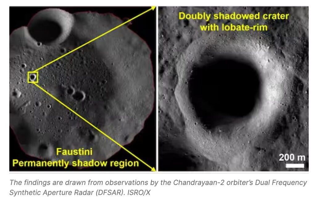
  • Researchers examined nine doubly shadowed craters (craters within permanently shadowed regions) near the lunar south pole using the orbiter’s radar payload.
    • Doubly shadowed craters are shielded from both direct sunlight and reflected thermal radiation from surrounding terrain. 
    • Their temperatures drop to approximately 25 Kelvin (−248°C), among the coldest known environments in the entire solar system. 
    • These conditions make them natural “cold traps” capable of preserving ancient water-ice over geological timescales spanning billions of years.
  • Using advanced radar polarimetric analysis (DFSAR), the team found evidence of subsurface ice beneath the floors of four out of the nine craters studied, located within the Faustini, Haworth, and Shoemaker crater regions. The strongest evidence was found in a small crater, approximately 1.1 km wide, nested inside the larger Faustini crater.

Key Instrument: Dual Frequency Synthetic Aperture Radar (DFSAR)

  • ISRO describes DFSAR as the first fully polarimetric SAR instrument designed to study the Moon, operating in both L-band and S-band frequencies, giving it the ability to probe beneath the surface at different depths.
  • The DFSAR is a microwave imaging instrument aboard the Chandrayaan-2 orbiter.
    • Rather than capturing photographs, it fires microwave signals at the lunar surface and analyses how they scatter back. 
    • Water-ice produces a distinctive backscatter pattern (called circular polarisation enhancement) that rock and regolith dust do not replicate. 

Significance: 

  • The findings could prove crucial for future lunar exploration missions, particularly those aimed at supporting a sustained human presence on the Moon.
    • Water ice is considered one of the most valuable potential resources on the lunar surface, as it could be transformed into drinking water, breathable oxygen, and even rocket fuel for future deep-space missions.
  • Enhances the utility of the region (near the South Pole of the Moon) for future lunar bases due to the possibility of accessible ice reserves within permanently shadowed craters. At the same time, nearby peaks receive almost continuous sunlight, making them well-suited for power generation.

Chandrayaan-2’s discovery of water on the Moon could prove to be a major achievement, as it may help power humanity’s next phase of space exploration.

Following the success of Chandrayaan-3, India has unveiled plans for Chandrayaan-4, a sample-return mission that could further explore resources near the lunar poles. The government has also outlined an ambitious plan to send an Indian astronaut to the Moon by 2040.