
Why in News?
ISRO has confirmed that NVS-03, launched aboard GSLV-F18 on 30 October 2026, is healthy after completing orbit-raising manoeuvres. The manoeuvres placed the satellite in a near-circular, inclined geosynchronous orbit.
However, in-orbit testing of its navigation payload remains necessary before operational readiness can be established.
| UPSC Relevance: GS-3 Science and Technology: Space Technology Prelims & Mains: Indigenous Satellite Navigation Technology; NaVIC |
About NVS-03:
- Third next-generation satellite: Part of the NVS series intended to maintain and strengthen services provided by the earlier Indian Regional Navigation Satellite System (IRNSS).
- Launch vehicle: GSLV-F18 placed it in a Geosynchronous Transfer Orbit (GTO) from Sriharikota.
- Navigation signals: Carries L1, L5 and S-band signals. L1 supports wider compatibility with civilian navigation receivers.
- Atomic clocks: Carries an indigenous atomic clock alongside procured clocks, strengthening domestic capability in precision navigation.
- NVS-03 has been designed for an operational life of around 12 years.
What is NavIC?
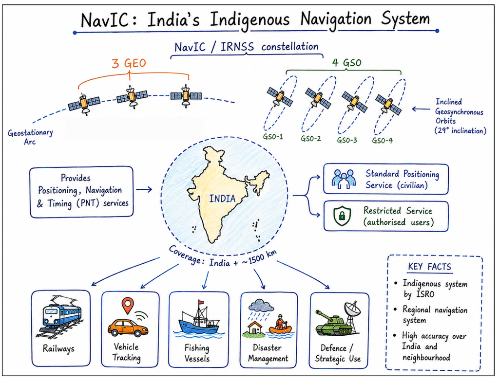
Navigation with Indian Constellation (NavIC) is India’s independent regional satellite navigation system, formerly called IRNSS.
- Coverage: India and approximately 1,500 km beyond its boundary.
- Services: Standard Positioning Service (SPS) for civilian users and Restricted Service (RS) for authorised strategic users.
- Original constellation design: Seven satellites (three geostationary and four inclined geosynchronous) supported by ground stations.
- Applications: Land, air and marine navigation; location-based services; surveying; and precise timing and synchronisation.
How does Satellite Navigation Work?
Navigation satellites broadcast their position and precise transmission time. A receiver uses signal travel times to estimate its distance from multiple satellites and calculate its location.
- Why atomic clocks matter: Even tiny timing errors translate into positioning errors.
- Why multiple satellites are needed: Normally, signals from at least four satellites allow a receiver to determine three-dimensional position and correct its clock error.
Why Is NVS-03 Significant?
- Strategic autonomy: Strengthens India’s ability to provide navigation and timing services independently of foreign systems.
- Service continuity: Supports replenishment and modernisation of the NavIC constellation.
- Civilian adoption: L1 signals can facilitate integration into compatible smartphones, vehicles and other receivers; actual use also requires supporting hardware and software.
- Critical infrastructure: Reliable timing supports telecommunications, power networks and other synchronised digital systems.
- Technological self-reliance: Indigenous atomic clocks reduce dependence on imported precision components.
NVS-03 advances India’s navigation capability, but its practical value will depend on successful payload testing, sustained constellation maintenance and widespread receiver adoption.
Prelims Practice MCQ:
Q. With reference to NavIC, consider the following statements:
- It is a regional satellite navigation system.
- Every geosynchronous satellite is also geostationary.
- NVS-03 carries L1 signals alongside L5 and S-band signals.
Which of the statements given above are correct?
(a) 1 and 2 only
(b) 1 and 3 only
(c) 2 and 3 only
(d) 1, 2 and 3
Answer: (b) A geostationary satellite must additionally have a circular, equatorial orbit.
Mains Practice Question
Q. An indigenous satellite navigation system strengthens India’s strategic autonomy and civilian infrastructure. Discuss.
Tell Google you want more of this.
Add Anantam IAS as a preferred sourceOne tap, and this site shows up more often in your own Top Stories, AI Overviews and AI Mode. Remove it any time.