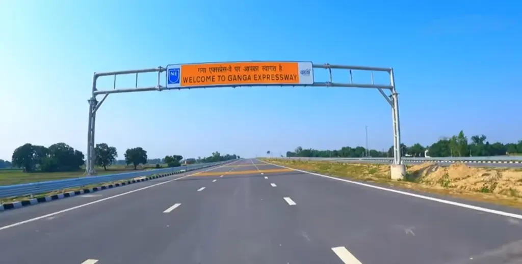
The Ganga Expressway is a 594 km, six-lane, access-controlled greenfield road in Uttar Pradesh that runs from Bijauli village near Meerut in the west to Judapur Dandu village near Prayagraj in the east. Prime Minister Narendra Modi opened it on 29 April 2026 in Hardoi district. It’s the longest expressway in the state, it passes through 12 districts, and it was built by the Uttar Pradesh Expressways Industrial Development Authority (UPEIDA) at a cost of about Rs 36,230 crore.
Two assumptions travel with it. Many readers think it’s a national highway built by the NHAI, and many think one company built the whole road. Neither is right. It’s a state project, and it was split into four contracts awarded on a toll-based public-private partnership. This note settles the route, the contract model and what the road is meant to do.
What Is the Ganga Expressway?
It’s a new road on land that had no highway before, which is what “greenfield” means. A brownfield project widens or upgrades an existing road; a greenfield one starts from fields.
| Fact | Detail |
|---|---|
| Length | 594 km (593.947 km in UPEIDA’s bid documents) |
| Ends | Near Bijauli village, Meerut, to near Judapur Dandu village, Prayagraj |
| Districts | 12: Meerut, Hapur, Bulandshahr, Amroha, Sambhal, Budaun, Shahjahanpur, Hardoi, Unnao, Rae Bareli, Pratapgarh, Prayagraj |
| Lanes | Six, expandable to eight |
| Developer | UPEIDA, Government of Uttar Pradesh |
| Model | DBFOT (toll) PPP, four groups |
| Cost | About Rs 36,230 crore (2026); over Rs 36,200 crore at the 2021 launch |
| Foundation stone | 18 December 2021, Shahjahanpur |
| Opened | 29 April 2026, Hardoi |
| Special feature | 3.5 km Emergency Landing Facility for Air Force aircraft in Shahjahanpur |
The headline benefit is time. The Prime Minister’s Office put the Meerut-Prayagraj drive at 10 to 12 hours before the road and about 6 hours after it. That roughly halves a journey between the two ends of India’s most populous state.
Where Does the Ganga Expressway Run?
It runs diagonally across Uttar Pradesh, from the western plains near Delhi to the confluence city of Prayagraj, roughly following the course of the Ganga at a distance. The 12 districts fall into three groups, and grouping them makes the route easy to recall:
- West: Meerut, Hapur and Bulandshahr, the industrial belt next to the National Capital Region.
- Middle: Amroha, Sambhal, Budaun, Shahjahanpur and Hardoi, largely agricultural districts of Rohilkhand and central Uttar Pradesh.
- East: Unnao, Rae Bareli, Pratapgarh and Prayagraj, toward the Ganga-Yamuna confluence.
Why the name? The road roughly follows the river, and the Prime Minister noted at the opening that the state government chose to name it after the Ganga. Its distance from the river isn’t an accident either. An older version of the project hugged the river and lost its environmental clearance, which the history below explains.
The expressway is also meant to be a spine for other roads. The PMO named link corridors that tie into it, either working or planned:
- the Agra-Lucknow Expressway;
- the Jewar Link Expressway, toward the Noida International Airport;
- the Farrukhabad Link Expressway;
- a proposed extension from Meerut to Haridwar.
That’s the real design idea. Uttar Pradesh is building a grid, and the Purvanchal Expressway to the east and the Ganga Expressway across the middle are its two longest pieces.
How Was the Ganga Expressway Financed?
The Ganga Expressway was built on a DBFOT (toll) model, a form of public-private partnership. The letters stand for design, build, finance, operate and transfer, and here’s how that works in practice:
- A private company designs the road and builds it.
- It raises much of the money itself, through equity and loans.
- It runs and maintains the road for a fixed concession period and collects the tolls.
- At the end of the period, the road passes back to the government.
There’s a catch. Toll income alone may not cover the cost of a long road through farmland, so bidders ask the state for a grant, a one-time support payment. Under UPEIDA’s tender the bidder quoting the lowest grant won each group. That’s the logic of competitive viability support: the less public money a company needs, the better its bid.
UPEIDA split the road into four groups and approved the selected bidders by a government order of 16 December 2021:
| Group | Selected bidder | Grant quoted |
|---|---|---|
| Group I | IRB Infrastructure Developers Ltd. | Rs 1,746 crore |
| Group II | Adani Enterprises Ltd. | Rs 1,720 crore |
| Group III | Adani Enterprises Ltd. | Rs 2,177 crore |
| Group IV | Adani Enterprises Ltd. | Rs 2,099 crore |
| Total | Rs 7,742 crore |
So the state committed about Rs 7,742 crore in grants against a stated project cost of about Rs 36,230 crore, roughly a fifth. Treat that as a rough ratio only: the official documents give the two totals, not a full breakdown of who paid for what, land included.
Compare this with the other PPP models in infrastructure. Under EPC the government pays the full construction cost and keeps the toll. Under the hybrid annuity model the government pays 40% during construction and the rest as annuities, so the private side carries no traffic risk. Under DBFOT (toll) the private side carries the traffic risk: if fewer vehicles use the road than forecast, it earns less. That risk transfer is the model’s strength and also its weak point, a trade-off the note on the analysis of PPP discusses in detail.
Why Did the First Ganga Expressway Fail?
The road that opened in 2026 is the second attempt. The first was announced in 2007 as a 1,047 km, eight-lane expressway from Greater Noida to Ballia along the river. A foundation stone was laid in January 2008, but the Allahabad High Court quashed the project’s environmental clearance in 2009 after petitions from environmental groups, and the project stalled for a decade.
The scheme was revived in January 2019 with a new Meerut-Prayagraj alignment. Reports at the time said the line was moved well away from the river channel to make compliance easier. That history is the best answer to anyone who asks why the “Ganga” Expressway doesn’t run beside the Ganga. A road on the floodplain risks embankment-like blocking of floodwater and damage to the river’s wetlands; a road a few kilometres away avoids most of that.
The lesson is about sequencing. The first project tried to build fast and clear the paperwork later. The second cleared the alignment question first, and the courts never stopped it.
What Are the Concerns Around the Ganga Expressway?
The concerns are about who pays and who benefits, more than about the road itself. A long greenfield road through farmland raises a predictable set of questions, and a balanced answer names them without dismissing the project.
- Land. A new 594 km alignment needs a continuous strip of farmland across 12 districts. Each acquisition is a family losing a field, and compensation disputes are the usual source of delay on such projects.
- Severance. An access-controlled road with fencing can split a village from its own fields. Underpasses and service roads fix this only where they’re placed well, and farmers notice every one that’s missing.
- Traffic risk. Under DBFOT the concessionaire earns from tolls. If traffic stays thin in the middle districts, the pressure falls on toll rates or on renegotiation, which is a known weak point of toll PPPs in India.
- Toll burden. A fast road helps those who can pay to use it. Trucks and buses gain most; a smallholder with a tractor gains little unless local markets grow near the exits.
- Ecology. Moving the alignment away from the river solved the biggest problem of the 2007 plan, but a raised road across the plains still changes drainage. Culverts and bridges have to let monsoon water pass, or fields upstream of the embankment stay waterlogged.
Why name these at all, if the road is already open? Because the same questions will decide the next expressways the state builds. The Meerut-Haridwar extension and the link roads will face each of them again, and an answer that weighs them shows judgment rather than cheerleading.
The state’s earlier roads give a useful baseline. Uttar Pradesh opened the Agra-Lucknow Expressway (302 km) in 2016, the Purvanchal Expressway (about 341 km) in 2021 and the Bundelkhand Expressway (296 km) in 2022. The Ganga Expressway is longer than any of them, and because its contracts depend on tolls, its traffic in the first few years will show whether the toll PPP route can carry the state’s next expressways.
Ganga Expressway Today
The Ganga Expressway has been open since 29 April 2026. At the inauguration in Hardoi the Prime Minister said the road had been completed in less than five years from its December 2021 foundation stone.
Three features decide how useful it becomes:
- The airstrip. A 3.5 km Emergency Landing Facility in Shahjahanpur district lets Indian Air Force aircraft land and take off on the expressway. The Purvanchal Expressway has a 3.2 km strip near Sultanpur; such stretches give the Air Force alternate runways in a crisis.
- The industrial nodes. The state plans Integrated Manufacturing and Logistic Corridors over about 2,635 hectares across the 12 districts. Without them, an expressway moves traffic past villages rather than bringing work to them.
- The links. The Jewar link to the Noida airport and the Farrukhabad link decide whether the road becomes part of a network or stays a single line.
The industrial piece is the one to watch. Uttar Pradesh’s defence corridor shows both the promise and the lag: land can be acquired quickly, but factories take years. The expressway’s value to a farmer in Budaun or Hardoi will depend less on the fast road itself than on whether a cold store, a mandi or a factory appears near an interchange.
For Prayagraj, the timing has a practical edge. The city hosts the Kumbh Mela, and a six-hour road from western Uttar Pradesh changes how pilgrims and supplies reach it for future gatherings.
How to Study the Ganga Expressway for Exams
The Ganga Expressway sits in General Studies Paper III under infrastructure, investment models and regional development. It also helps in Paper I answers on regional disparity within Uttar Pradesh, and in Prelims as a fact question about routes, districts and models.
Revision facts to keep:
- 594 km, Meerut (Bijauli) to Prayagraj (Judapur Dandu), 12 districts.
- Built by UPEIDA, a state body, not the NHAI.
- DBFOT (toll) PPP in four groups; IRB won Group I, Adani Enterprises Groups II to IV; total grant Rs 7,742 crore.
- Foundation stone 18 December 2021 at Shahjahanpur; opened 29 April 2026 at Hardoi.
- Cost about Rs 36,230 crore; six lanes, expandable to eight.
- 3.5 km Emergency Landing Facility in Shahjahanpur.
Keep three pairs apart. The Ganga Expressway is a state road; the Delhi-Dehradun Expressway, which gets its own note in this series, is an NHAI road under Bharatmala. The Ganga Expressway’s airstrip is in Shahjahanpur; Purvanchal’s is near Sultanpur. And the 2026 road is not the 2007 Greater Noida-Ballia plan, which died in court.
| Expressway | Length | Developer | Opened | Ends |
|---|---|---|---|---|
| Ganga | 594 km | UPEIDA | 29 April 2026 | Meerut to Prayagraj |
| Purvanchal | About 341 km | UPEIDA | 16 November 2021 | Lucknow to Ghazipur |
| Delhi-Dehradun | About 210-213 km | NHAI | 14 April 2026 | Delhi to Dehradun |
For the national picture, the national highway system note explains how state expressways and Union highways fit together.
How is it tested? Mains rarely names one road; it asks about investment models and growth. Mains 2013 GS Paper III asked: “Adoption of PPP model for infrastructure development of the country has not been free of criticism. Critically discuss pros and cons of the model.” The Ganga Expressway’s grant-based DBFOT contracts are a ready example for that question. Prelims draws on economy most of all: 256 of the 1,403 questions in the Prelims bank from 2013 to 2026 are on the Indian economy.
The judgment for your preparation: learn the Ganga Expressway for its contract, not its length. Anyone can write “594 km, 12 districts”. An answer that explains why the state chose DBFOT, what the Rs 7,742 crore grant bought and why the 2007 version failed shows that you understand how India actually builds roads.
Frequently Asked Questions
What is the route of the Ganga Expressway?
It starts near Bijauli village in Meerut and ends near Judapur Dandu village in Prayagraj. On the way it passes through Hapur, Bulandshahr, Amroha, Sambhal, Budaun, Shahjahanpur, Hardoi, Unnao, Rae Bareli and Pratapgarh, making 12 districts in all.
When was the Ganga Expressway inaugurated?
Prime Minister Narendra Modi inaugurated it on 29 April 2026 in Hardoi district of Uttar Pradesh. He had laid the foundation stone on 18 December 2021 at Shahjahanpur.
How long is the Ganga Expressway?
It’s 594 km long; UPEIDA’s bid documents give the exact figure as 593.947 km. That makes it the longest expressway in Uttar Pradesh.
Who built the Ganga Expressway?
UPEIDA, a body of the Uttar Pradesh government, developed it. The construction was split into four groups awarded on a toll-based PPP: IRB Infrastructure Developers won Group I and Adani Enterprises won Groups II, III and IV.
What is the DBFOT model used for the Ganga Expressway?
DBFOT stands for design, build, finance, operate and transfer. The private company builds the road with its own money, collects tolls for a fixed period and then hands it back to the state. UPEIDA also paid a one-time grant, and the bidder asking for the lowest grant won each group.
Is there an airstrip on the Ganga Expressway?
Yes. A 3.5 km Emergency Landing Facility in Shahjahanpur district allows Indian Air Force aircraft to land and take off on the expressway in an emergency.
How much time does the Ganga Expressway save?
The Prime Minister’s Office put the Meerut-Prayagraj journey at 10 to 12 hours before the expressway and about 6 hours on it. That roughly halves the trip between the two ends of the route.
Practice Questions
Prelims
1. Consider the following statements about the Ganga Expressway: 1. It was developed by the National Highways Authority of India under Bharatmala Pariyojana. 2. It was awarded in four groups on a DBFOT (toll) public-private partnership basis. Which of the statements given above is/are correct?
- (a) 1 only
- (b) 2 only
- (c) Both 1 and 2
- (d) Neither 1 nor 2
Answer: (b) UPEIDA, a state body, developed it in four DBFOT (toll) groups.
2. The Emergency Landing Facility on the Ganga Expressway is located in which district?
- (a) Sultanpur
- (b) Hardoi
- (c) Shahjahanpur
- (d) Unnao
Answer: (c) The 3.5 km airstrip is in Shahjahanpur; the Purvanchal Expressway’s strip is near Sultanpur.
3. Consider the following statements: 1. The Ganga Expressway runs from Meerut to Prayagraj. 2. It passes through Agra and Lucknow districts. Which of the statements given above is/are correct?
- (a) 1 only
- (b) 2 only
- (c) Both 1 and 2
- (d) Neither 1 nor 2
Answer: (a) Its 12 districts don’t include Agra or Lucknow; the Agra-Lucknow Expressway is a separate link corridor.
4. In a DBFOT (toll) project, who normally bears the risk that traffic will be lower than forecast?
- (a) The government, through annuity payments
- (b) The private concessionaire
- (c) The road users
- (d) The lending banks alone
Answer: (b) The concessionaire’s income depends on tolls, so it carries the traffic risk.
5. The original Ganga Expressway proposal of 2007 was planned between which two places?
- (a) Greater Noida and Ballia
- (b) Meerut and Prayagraj
- (c) Agra and Lucknow
- (d) Lucknow and Ghazipur
Answer: (a) The 1,047 km Greater Noida-Ballia plan stalled after the Allahabad High Court quashed its environmental clearance in 2009.
Mains
- ‘Investment in infrastructure is essential for more rapid and inclusive economic growth.’ Discuss in the light of India’s experience. (15 marks, 250 words) Previous year: Mains 2021, GS Paper III.
- Compare the DBFOT (toll), hybrid annuity and EPC models of road development. Which one suits long greenfield expressways in agrarian states, and why? (15 marks, 250 words)
- Expressways do not automatically become economic corridors. Examine with reference to the Ganga Expressway in Uttar Pradesh. (10 marks, 150 words)
- Discuss the strategic significance of emergency landing facilities on Indian expressways. (10 marks, 150 words)
- What lessons does the failure of the original Ganga Expressway proposal offer for environmental appraisal of large infrastructure projects near rivers? (15 marks, 250 words)
Tell Google you want more of this.
Add Anantam IAS as a preferred sourceOne tap, and this site shows up more often in your own Top Stories, AI Overviews and AI Mode. Remove it any time.