

Highest Peak in India: Mountains & Ranges Complete Guide
Kangchenjunga is the highest peak in India at 8,586 metres above sea level. It sits on the border of Sikkim and Nepal. It’s also the third highest mountain in the world after Mount Everest (8,849m, Nepal-Tibet) and K2 (8,611m, Pakistan-China border).
Don’t confuse this. K2 is the second highest mountain in the world and lies in the Karakoram range in Pakistan-administered Kashmir. India administers parts of Ladakh near K2’s broader region, but K2 itself is not on Indian-administered territory.
States of India: Complete List with Capitals & Map
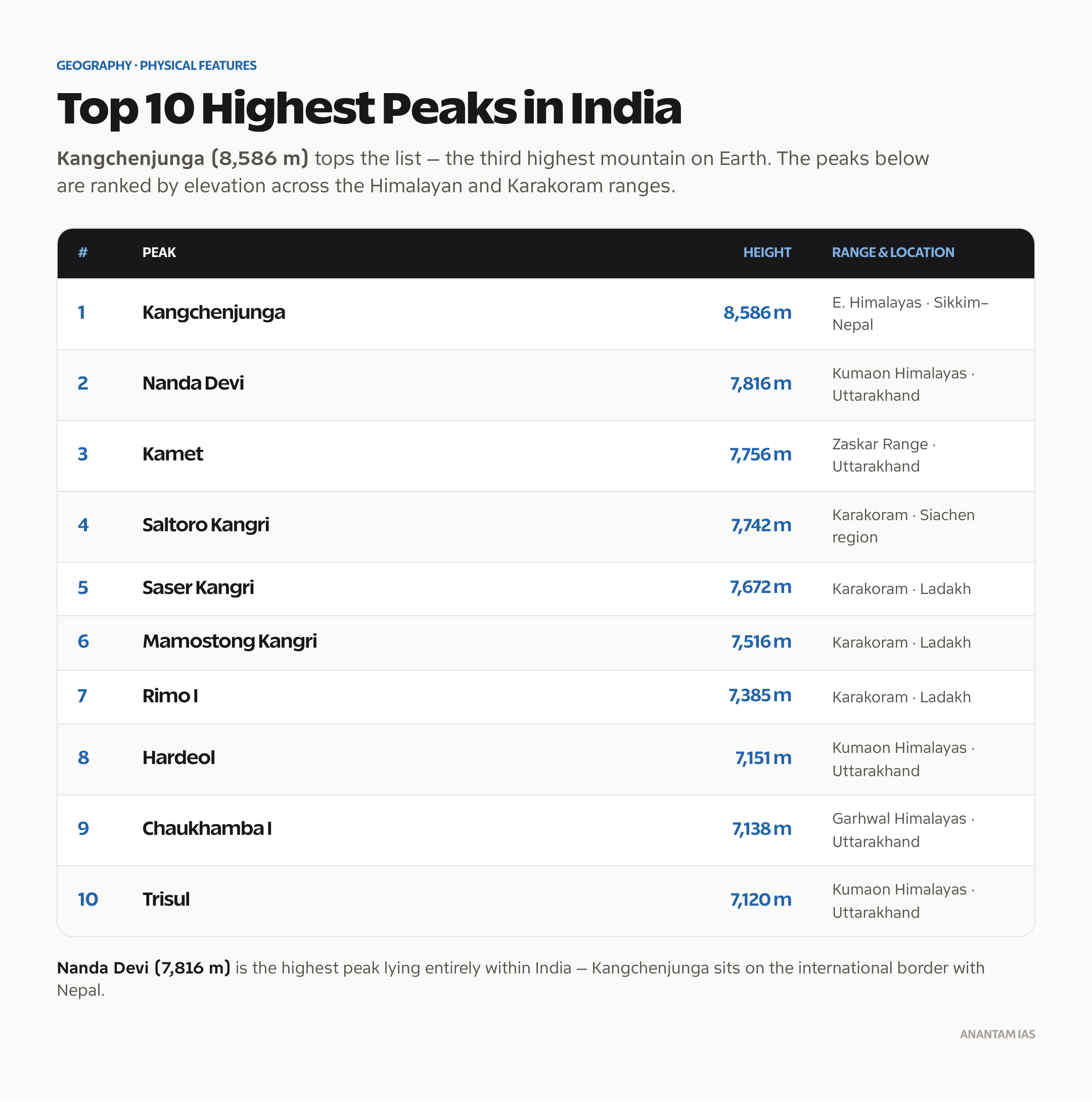
Top 10 Highest Peaks in India
| Rank | Peak | Height (m) | Range | Location |
|---|---|---|---|---|
| 1 | Kangchenjunga | 8,586 | Himalayas (Eastern) | Sikkim-Nepal border |
| 2 | Nanda Devi | 7,816 | Kumaon Himalayas | Uttarakhand |
| 3 | Kamet | 7,756 | Zaskar Range | Uttarakhand |
| 4 | Saltoro Kangri | 7,742 | Karakoram | J&K / Siachen |
| 5 | Saser Kangri | 7,672 | Karakoram | Ladakh |
| 6 | Mamostong Kangri | 7,516 | Karakoram | Ladakh |
| 7 | Rimo I | 7,385 | Karakoram | Ladakh |
| 8 | Hardeol | 7,151 | Kumaon Himalayas | Uttarakhand |
| 9 | Chaukhamba I | 7,138 | Garhwal Himalayas | Uttarakhand |
| 10 | Trisul | 7,120 | Kumaon Himalayas | Uttarakhand |
Key point: Nanda Devi is the highest peak entirely within India (7,816m). Kangchenjunga lies on the international border with Nepal.
Kangchenjunga: Everything You Need to Know
Kangchenjunga means “Five Treasures of Snow” in Tibetan — referring to its five peaks. The name comes from the five summits, which represent five repositories of God: gold, silver, gems, grain, and holy scripture.
Location: Eastern Himalayas, on the Sikkim-Nepal border. Coordinates: approximately 27.7°N, 88.1°E.
Height: 8,586 metres (28,169 feet)
World rank: Third highest mountain globally
First ascent: May 25, 1955, by George Band and Norman Hardie of a British expedition. Per a request by the Chogyal (king) of Sikkim, the climbers stopped a few metres short of the summit out of respect for the sacredness of the peak.
India’s relationship with it: The Sikkim-Nepal border runs through the massif. India claims it as its highest peak.
Biosphere Reserve: Kangchenjunga Biosphere Reserve in Sikkim is a UNESCO World Heritage Site (inscribed 2016). It’s a critical habitat for snow leopards, red pandas, and Himalayan black bears.
Nanda Devi: Highest Peak Entirely in India
Nanda Devi at 7,816 metres is the highest mountain that sits entirely within Indian territory. It’s located in the Chamoli district of Uttarakhand.
Nanda Devi National Park was established in 1982 and is a UNESCO World Heritage Site. The mountain has been closed to climbers since 1983 due to environmental concerns and a classified CIA/IB operation in the 1960s that reportedly placed a nuclear-powered monitoring device on it.
The inner sanctuary of Nanda Devi is surrounded by a ring of peaks forming one of the most spectacular natural fortresses in the Himalayas. Rivers from this sanctuary feed the Rishi Ganga.
Himalayan Ranges: The Three Parallel Zones
The Himalayas aren’t a single mountain range. They’re a series of parallel ranges running northwest to southeast. UPSC asks about these consistently.
Greater Himalayas (Himadri)
This is the northernmost and highest range. Average height exceeds 6,000 metres. It contains:
- All peaks above 8,000 metres (Eight-thousanders)
- Perpetual snow cover year-round
- The main Himalayan watershed
Key peaks in the Greater Himalayas: Kangchenjunga, Everest (shared Nepal side), Nanda Devi, Kamet.
The Greater Himalayas are asymmetrical — the northern slope is gentle (towards Tibet), while the southern slope is steep.
Lesser Himalayas (Himachal)
Lies south of the Greater Himalayas. Average height: 3,700 to 4,500 metres.
Contains:
- Mussoorie, Shimla, Nainital, Darjeeling, Ranikhet — all major hill stations sit in this range
- Pir Panjal range — runs through J&K, forming the southern wall of the Kashmir Valley
- Dhauladhar range — in Himachal Pradesh
- Mahabharat range — in Nepal portion
The Lesser Himalayas are the most densely populated part of the Himalayan zone.
Shivalik Hills (Outer Himalayas)
The southernmost and lowest range. Height: 900 to 1,200 metres. Also called Sub-Himalayas.
Key features:
- Dun valleys: Elongated valleys between Shivalik and Lesser Himalayas — Dehradun, Patlidun, Kotlidun
- Made of unconsolidated sedimentary material (clay, sand, gravel)
- Prone to erosion
- Terai zone lies at the foot of the Shivaliks
Trans-Himalayan Ranges (Beyond the Main Himalayas)
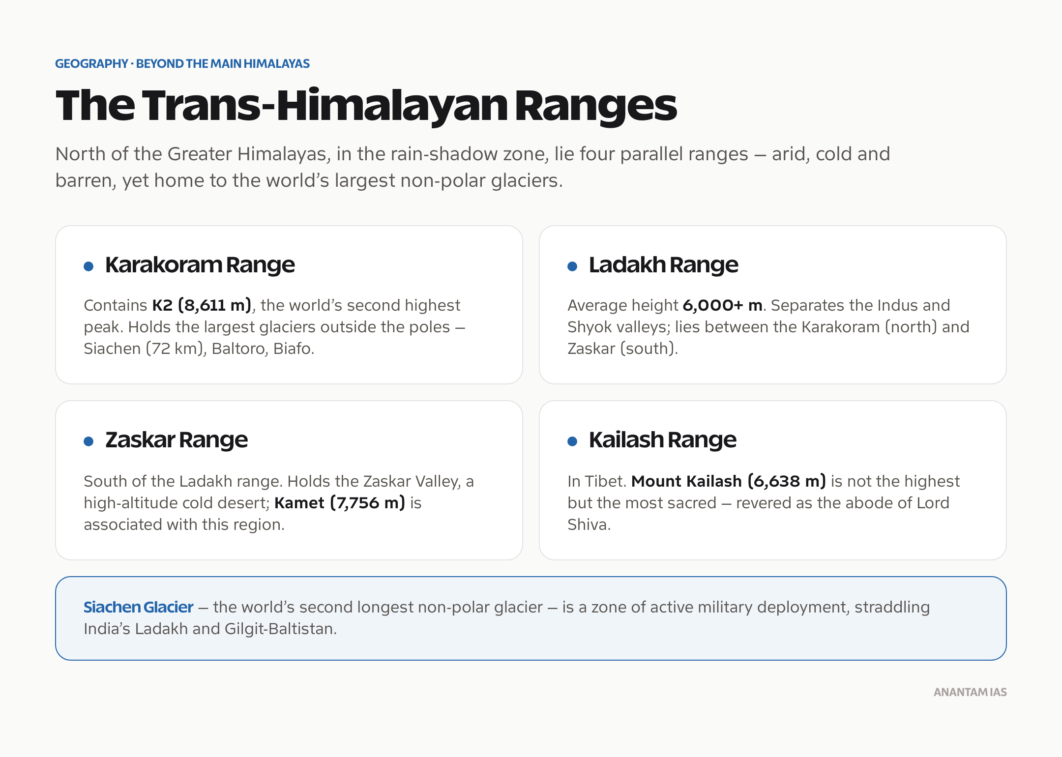
These ranges lie north of the Greater Himalayas, in the rain shadow zone. They include:
Karakoram Range
- Contains K2 (8,611m) — world’s second highest
- Largest glaciers outside the polar regions: Siachen Glacier (72km), Baltoro Glacier, Biafo Glacier
- Siachen Glacier is the world’s second longest non-polar glacier and a zone of active military deployment (India vs Pakistan)
- Straddles India’s Ladakh and Pakistan-occupied Gilgit-Baltistan
Ladakh Range
- Average height: 6,000+ metres
- Separates the Indus and Shyok valleys
- Lies between Karakoram (north) and Zaskar (south)
Zaskar Range
- South of the Ladakh range
- Contains the Zaskar Valley, a high-altitude cold desert
- Peaks like Kamet (7,756m) are associated with this region
Kailash Range
- In Tibet, but revered by Hindus as the abode of Lord Shiva
- Mount Kailash (6,638m) is not the highest but is the most sacred
Himalayan Ranges in India: State-wise
| State/UT | Ranges Present | Key Peaks |
|---|---|---|
| Sikkim | Eastern Himalayas | Kangchenjunga |
| West Bengal | Darjeeling Himalayas | Sandakphu (3,636m) — highest point in WB |
| Arunachal Pradesh | Eastern Himalayas | Kangto (6,859m), Nyegi Kangsang |
| Uttarakhand | Garhwal and Kumaon Himalayas | Nanda Devi, Kamet, Trisul |
| Himachal Pradesh | Western Himalayas | Reo Purgyil (6,816m) |
| J&K | Pir Panjal, Zaskar, Karakoram | Saltoro Kangri |
| Ladakh (UT) | Karakoram, Zaskar, Ladakh | Saser Kangri, Mamostong |
Eastern Ghats and Western Ghats: Not the Himalayas
Many students confuse these with mountain “peaks” in the Himalayan sense. The Ghats are different in origin and character.
Western Ghats
- Run parallel to the western coast, from Gujarat to Kerala (~1,600 km)
- A continuous escarpment, not a fold mountain range
- UNESCO World Heritage Site (2012)
- Highest point: Anamudi (2,695m) in Kerala — also the highest peak in peninsular India
- Key passes: Palakkad Gap, Thal Ghat, Bhor Ghat
- Origin of rivers: Godavari, Krishna, Kaveri, Periyar
- Biodiversity: One of the world’s eight “hottest hotspots” for biological diversity
Eastern Ghats
- Discontinuous range parallel to the eastern coast
- Much lower and broken than Western Ghats
- Highest point: Arma Konda (1,680m) in Andhra Pradesh (in Vishakhapatnam district)
- Also: Jindhagada Peak in Eastern Ghats is sometimes listed as 1,690m — check current exam sources
- Intersected by east-flowing rivers: Mahanadi, Godavari, Krishna, Kaveri
Comparison Table: Western vs Eastern Ghats
| Feature | Western Ghats | Eastern Ghats |
|---|---|---|
| Continuity | Continuous | Discontinuous |
| Average Height | 1,000–1,500m | 600m |
| Highest Peak | Anamudi (2,695m) | Arma Konda (~1,680m) |
| Parallel to | West coast | East coast |
| Rainfall | High (windward side) | Moderate |
| River origin | Several peninsular rivers | Receives rivers from W Ghats |
| UNESCO Status | World Heritage Site (2012) | Not listed |
Peninsular India’s Highest Peaks
| Peak | Height (m) | Location |
|---|---|---|
| Anamudi | 2,695 | Kerala (Western Ghats) |
| Doddabetta | 2,637 | Nilgiri Hills, Tamil Nadu |
| Makurti Peak | 2,554 | Nilgiri Hills, Tamil Nadu |
| Vellangiri | 1,844 | Coimbatore, Tamil Nadu |
| Kalsubai | 1,646 | Maharashtra (Sahyadri) |
| Arma Konda | ~1,680 | Andhra Pradesh (Eastern Ghats) |
Nilgiri Hills are the meeting point of the Western and Eastern Ghats in Tamil Nadu. Ooty (Udhagamandalam) is situated here. The Nilgiris Biosphere Reserve is India’s first biosphere reserve (designated 1986).
Key Mountain Passes in India
Mountain passes are critical for connectivity and military strategy. UPSC asks about these often.
| Pass | Mountain Range | State/UT | Connects |
|---|---|---|---|
| Zoji La | Greater Himalayas | J&K | Srinagar to Leh |
| Baralacha La | Zaskar | Himachal Pradesh | Manali to Leh |
| Chang La | Ladakh Range | Ladakh | Leh to Pangong |
| Khardung La | Ladakh Range | Ladakh | Leh to Siachen (claimed world’s highest motorable) |
| Rohtang Pass | Pir Panjal | Himachal Pradesh | Manali to Lahaul-Spiti |
| Shipki La | Greater Himalayas | Himachal Pradesh | India-China border (Sutlej enters India) |
| Nathu La | Himalayas | Sikkim | India-China border, reopened 2006 |
| Bomdi La | Himalayas | Arunachal Pradesh | India-China border |
| Palakkad Gap | Western Ghats | Kerala-Tamil Nadu | Natural gap, important for monsoon |
Frequently Asked Questions
Q: What is the highest peak in India?
Kangchenjunga is the highest peak in India at 8,586 metres. It sits on the Sikkim-Nepal border in the Eastern Himalayas and is the third highest mountain in the world. Nanda Devi (7,816m) in Uttarakhand is the highest peak located entirely within India’s territory.
Q: Is K2 in India?
K2 at 8,611 metres is the world’s second highest peak. It lies in the Karakoram range in Pakistan-administered Gilgit-Baltistan (near Pakistan-occupied Kashmir). It’s not in Indian-administered territory, though India claims the entire J&K including PoK.
Q: What is the highest peak in South India?
Anamudi (2,695m) in Kerala’s Western Ghats is the highest peak in peninsular India and South India. It’s located in the Eravikulam National Park in Kerala.
Q: What is the difference between Greater Himalayas and Lesser Himalayas?
The Greater Himalayas (Himadri) form the northernmost, highest, and most continuous range with peaks above 6,000m and permanent snow. The Lesser Himalayas (Himachal) lie south of the Greater Himalayas with heights of 3,700–4,500m and contain major hill stations like Shimla, Mussoorie, and Darjeeling.
Q: Which is the highest peak in Northeast India?
Kangchenjunga (8,586m) on Sikkim’s border is the highest. Within Arunachal Pradesh, Kangto (6,859m) is among the highest peaks.
Tell Google you want more of this.
Add Anantam IAS as a preferred sourceOne tap, and this site shows up more often in your own Top Stories, AI Overviews and AI Mode. Remove it any time.






